334
APPLICATION OF HGML-BASED FIRE DATA
MANAGEMENT IN FIRE COMMAND SYSTEM
LEI CAO,FANG MIAO*, WENHUI YANG
Chengdu University of Technology, Key Lab of Earth Exploration and Information Techniques of Ministry of Education Chengdu China 610059
* corresponding author: FANG MIAO
ABSTRACT
In recent years, many experts and technicians have done extensive research in many respects such as the computer software for fire, experimental simulation, material thermal physical measurement, which put forward the Fire prediction theory, and these theoretical results were data-centric, existing in the form of multi-source heterogeneous. The existing fire service system can't make vast amounts of multi-source heterogeneous fusion effectively, and it can't timely organize and analyze the data, for it is lacking the comprehensive analysis function. This paper, based on the hyper geographical markup language HGML and Fire spreading algorithm model, designed a kind of fire data management, which can be applied to rescue command simulation systems. The system can make the geographic coordinates of the scene of fire and the multi-source heterogeneous data fusion effectively. And it can comprehensively analyze the date and use 3D simulation of the scene to put forward the aided decision and rescue plan. The HGML-based rescue command simulation system can command the firefighting effectively, which played an important role for the fire service.
Keywords: HGML, Space-time Deduction, 3D Simulation, Fire Protection System
1. INTRODUCTION
The frequently occurring fire disasters around the world not only causes great damage to people's life and property, but also affects the national economic construction and stability. Due to geographical circumstances, meteorological conditions and the building structure, the rescue team can’t control the scene of the fire timely and accurately. So the fire emergency plan can’t be carried out quickly and effectively, which is hard to adapt to the modern fire-fighting battle command and dispatch needs. In order to solve these problems effectively, the construction of the fire department must realize informationization, emergency, and standardization. Thus, here is an urgent need to emergency response mechanism for the city fire-fighting, in order to achieve the purpose of early prevention, early treatment, and the precautionary measures. Still, emergency response capabilities of fire and accidents should be enhanced, to protect the nation and people's lives and property.
With the advent of the information age, the fire protection system started to use the information technology such as Web technologies, and 3S technology (GIS, GPS, and RS), which presented that the fire protection system had made great strides. However, due to the inconsistencies of the
development standards and development mode, there were some problems such as the lack of information, lack of analysis function, weak compatibility, lack of real-time, and so on.
335 bandwidth were reduced, leading to a good balance between the load on the server and client. It had important influence on the fire-fighting supporting decision, life insurance, and so on.
2. BASIC THEORY
2.1 Hyper Geographic Markup Language (HGML)
HGML ( Hyper Geographic Markup
Language)is the new data exchange standards which based on the new space information network access mode---G/S, It is based on XML, GML and KML class,Combined with the advantages of the three.geneous space of mass data,which can transparent access space heterogeneous data of distributed environment, And can be unified management and efficient scheduling in mass of heterogeneous data which stored in distributed spatial data server such as space basic data and industry application data. The function and structure in the mode of HGML in G/S as below:
The Commanding Platform for Fire-fighting System G
The Data’s Calling, Exchanging and Displaying Based on HGML
Internet/Intranet(HTTP)
The Data’s Organizing, Storing and Managing Based on HGML
The Service Cloud of Spatial Information S
The Basic Data of Spatial Geography
The Basic Data of Spatial Geography
The Industry Data of Fire-fighting System
The Industry Data of Fire-fighting System
Figure 1: G/S Mode Function Structure
To geonomy browser G,HGML mainly realize the heterogeneous spatial data scheduling, exchange and display. It provide means to share data and interoperate on the G/S mode for user. which provide for foundation support for 2D and 3D application. For space information server group S, HGML realize the space heterogeneous data organization, storage and management functions .In the G/S mode structure,So in data management need to format conversion。HGML has been most GIS software vendors and third party software manufacturer support ,So it will not have the information loss when using HGML realize space heterogeneous data format conversion, And it has three characteristics :flexible operation, extensible, cross-platform-ability.
2.2 Fire Spreading Algorithm Model
At present ,in the field of fire spread research limited to the flames and smoke flow characteristics within a single building when a fire. To analysis the specific conditions of the city with classic flame spread speed model, ,will simplify the influence of factors of fire spread,item by item ,in consideration. The model for the constitutive equation:
0
v H Q
ρ ∆ = (1) In the equation (1), ρ stand for the density of combustible;v0 stand for fire spread speed;ΔH As the unit of quality from the initial temperature rising fuel to the flame temperature prearcing equivalent enthalpy increment of Ti ;Q stand for flame heat transfer speed。After derivation , Can deduce that under the conditions of no wind and no slope ,the fire spread for velocity formula .
(
)(
)
0 0 1 1i vT T R
ρ =
− −
(2)
In the equation (2),R stand for Fuel in the process of hot heat loss.
Part of the building of wood structure, the woodiness furniture within the building Is the main combustible to the fire spread. Building of minerals such as cement the burning material and the water containing combustible affecting reaction rate also are important factors. Buildings, the furniture and so on are generally long-term placed in the natural environment . So T0 is equivalent to spring, summer, autumn, winter 4 season’s average temperature of the natural environment . Therefore, in the wind and gradient conditions for the biggest spread velocity formula is
(
)
(
)
0 1 w s 0 1 ws
v=v + Ψ + Ψ =v + Ψ (3)
In the equation (3) Ψs, Ψw stand for respectively wind and speed correction coefficient; Ψsw stand for comprehensive correction coefficient .
can be calculated as follows:
2 2
2 cos
ws w s w s
Ψ = Ψ + Ψ + Ψ Ψ ∂ (4)
In the equation (3),αstand for wind direction and the direction of the uphill Angle. The biggest fire spread speed direction θ Can be obtained by the following formula
sin arcsin w
sw
θ = Ψ ∂
336 The whole process of development of fire can be generalized by fire spreading model and indoor smoke movement model the two typical child model . The spread of fire , a process of chemical reactions, is heat and mass transfer, which is the main factor of the development of indoor fire. Indoor fire process is a turbulent combustion process . Due to the complicated composition of volatile combustible material , by different composition and oxygen burning chemical reaction to differentiate,the fire development process is comprehensive results of burning reaction.
3. THE METHODS
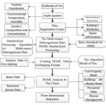
[image:3.612.90.293.280.481.2]3.1 Research Methods
Figure 1 Research Methods Figure
When fire breaks out , in a fire alarm system of buildings obtain the various parameters of the fire,include fire occurred terrain 、environment temperature 、humidity and from found the fire To the current time all stages of the smoke ingredients and concentration, etc . After alarm system obtained data, Through the sensor network will these messages send to HGML server to generate HGML inquires, HGML inquires according to coordinates of fire,access each database for data (For larger terrain data is back in the server URL links).As from the weather bureau for the weather conditions, wind speed, wind direction and other meteorological information when fire occurred, From space information database access fire place terrain data, traffic and other information. After server obtain these more source heterogeneous space the data, according to the data storage space mapping relationship model and the multiple source
data analytical algorithm , multi-source data space can be analysised, and then, make standardized treatment according to the basic standards HGML and heterogeneous space data standardization processing algorithm, formation HGML files output, generation HGML exchange format. After the client sends the server request. According to the definition of the fire spreading model algorithm ,the server conduct mathematical operations, And then transfer to the client, The client analysis out address from HGML file by the HGML parser ,and then download documents to the local machine(Or by the server to download a computational model , analysis data, and results back to the local by HGML). Shunting or stratifying the data, forming map data、fuilding model data、fuel attributes list、building attributes list static data, etc, The fire occurred of temperature, humidity, the fire and spread, gas composition and its concentration on the dynamic data real-time sensor ,and fire industry data. After client store these hierarchical data, according to the data ,we can conduct the fire accident 3D simulation demonstration,including emergency plan analysis, regional risk assessment, diffuse pollution simulation, scheduling and so on,to help for fire service
3.2 Data Registration Center
There are a lot of structured, semi-structured and unstructured data in the fire-fighting and rescue command system. And there exists a logical connection between the different types of data. It provides data services for the outside world in the form of fire industry application data set. The managers need to maintain a large number of database systems, distributed file systems and application servers. Because of the complexity of the heterogeneous environment and the dynamic changes of the information, the server is difficult to sharing and integrating all the data resources directly, so it can only through the data registration center make different data source and metadata information centralized, to achieve the purpose of sharing spatial information resources through unified management and maintenance of metadata.
337 also has a lot of pressure in data storage.
This paper makes metadata storage and index phase strip, and they are respectively associated to the library of metadata repository and the library of metadata indexing. With the strategy of distributed management adopted in the two libraries, a large number of metadata contents are stored. Actually, the metadata data storage library is composed of multiple database with the same function, and the metadata indexing library stores all repository metadata index.
The metadata repository uses a distributed architecture, which is deployed in various business management department, and each repository is in charge of the relevant subset of all registered metadata. It takes autonomy principle in data management. The subset of metadata can be divided by organization, data types or geographical factors.
[image:4.612.123.277.471.712.2]3.3 The Standardized Processing of HGML Fire service system is built on the basis of HGML , through the exchange of data ,each database about geographical information can be associated which formed in the urban design and build process , forming a comprehensive data analysis platform. Using the intelligence suggests fire control system, effective maintenance and management will come true in the current stage. The standardized processing procedure of multi-source heterogeneous data HGML in Fire command is shown in Figure 3:
Figure 2 HGML Encapsulation Schemes
338 3.4 The Generation Of The Format For The
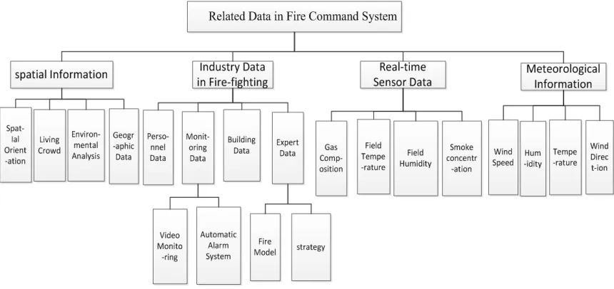
[image:5.612.91.521.168.371.2]HGML Data Exchanging
Figure 3 Fire Control 3d Deduction System Related Data
[image:5.612.306.509.433.552.2]HGML elements class tree have defined all elements, specific shown below: The HGML upper is a more detailed analysis and expansion relative to lower, For example, fire industry data including the personnel data, monitoring data, building data, experts data, etc. Part of the class stated below:
Table 1:HGML Class Function Table
Class name Function
Space
deduction Deduce fire occurred time and space
Time span Describe the Lag between the fire Occurrence time and current time
Time mark Describe the situation for each time period
fire
Geographic
coordinates The fire occurred geographical position
Map information
The fire occurred on the map shows the surrounding environment such as
transportation, water, etc
strategy
With the relevant data, conduct the shortest path selection, buffer analysis, rescue
management, etc
Fire model
With the relevant data analysis fire building properties, environmental temperature, humidity and wind speed,
wind direction affects the fire spread.
Table 2 : HGML Data Identification Table
Data identification Data type
string String data type
int Int data type
uint Uint data type
short Short data type
ushort Ushort data type
float Float data type
double Double data type
bool Bool data type(0 or 1)
< deduction> <Time >
< equation > float </ equation > <Sign>string</ Sign >
</ Time > < Space > < Coordinate > <lon>float</lon> <lat>float</lat> </ Coordinate > < MapInformation >
< Information >… </ Information > </ MapInformatio >
[image:5.612.86.285.524.709.2]339 <Strategy>
< Information >… </ Information > </ Strategy >
<Fire model>
< Information >… </ Information > </Fire model>
</ deduction > Explanation:
Time and space deduction is an important function in fire control system. It use of Time and Space class define the time and space information, equation means time span,Sign means time mark, Coordinate means geographic coordinates, lon define longitude, lat define latitude, Map Information means map information, Strategy means strategy, Fire model means fire model, Among them Map Information, Strategy and Fire
model have information class calling relational database data to show.
3.5 The HGML Client Resolver:
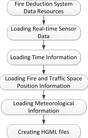
[image:6.612.93.532.321.514.2]After HGML define format,effective data and information should be applied if we want to use it, and finally using the form of visual to display. HGMLL mainly adopts the SAX analytical technology. SAX can read data and analysis it at the same time, and it will stop analysis when reach a set conditions, with a higher rate analysis in dealing with large documents. On a visit to the XML document SAX use is event model, the user in the client can through component to operate the requested HGML data,all of the operation were made by the client data processing components to complete, system response quickly, so HGML mainly USES the SAX system strategy, the specific analytical process is shown as below:
Figure 5 HGML Analytical
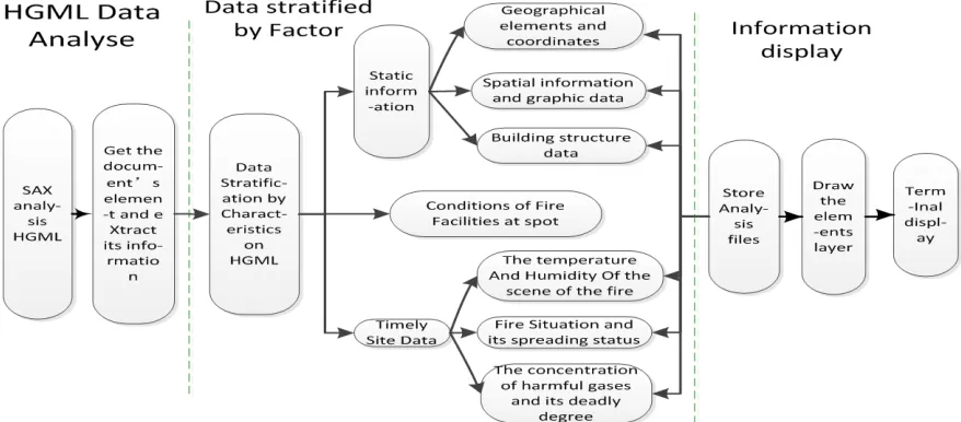
Because HGML data analytical extract multi-source heterogeneous space information multi-source, including weather information, spatial data, fire industry data and real-time sensor data, etc, information is not only large and complex, it affects the visualization directly, and reduce operating efficiency. In order to increase the visualization and the operation efficiency of deduction, it will need to convert mutilsource heterogeneous data into HGML data file, and then to reverse analytical for the gotten document object model. HGML analytical data of three step to achieve:firstly, use SAX analysis HGML documentation, HGML documents are loaded by SAX parser, SAX
340 geographical spatial information and coordinate, graphic data, building structure data; Finally, the data layered by elements store into information, descript it and display into easy-to-read information in each terminal ,convenient to make auxiliary command decisions.
4. EXPERIMENTS DESIGN
Miniature fire experiment mainly have these hardware configuration:Material heating device, the data acquisition device, detection equipment, auxiliary sensor, the combustion chamber and measure the room; software configuration, which is based on the HGML 3 d intelligent deduction system,alarm system.
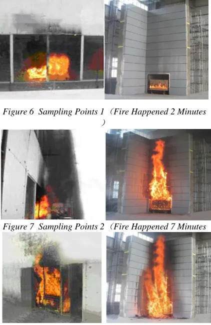
In the 3D simulation setting and in the miniature fire experiments scene, select three sampling points in time benchmark, for respectively 2 minutes, 7 and 11 minutes after fire happened, The following is a three sampling point simulation scene and experimental scene contrast graph. (the left for the simulation scene, the right for the experimental scene.
Figure 6 Sampling Points 1(Fire Happened 2 Minutes
)
[image:7.612.316.521.96.197.2]Figure 7 Sampling Points 2(Fire Happened 7 Minutes
Figure 8 Sampling Points 3(Fire Happened 11 Minutes
)
Table 3: Laboratory Data Obtained In The List Below:
Building
materials tempera
ture Humi
dity Wind
speed
Wind
direct
ion Ter
rain Sprea
d
speed Spread
directio
n
wood 20℃ 43% 1. 385m/s 60° 8° 1.753 NE 19°
coating 22℃ 34% 1. 37 m/s 60° 8° 0.721 NE 18°
Polymer 23℃ 28% 1. 38 m/s 60° 8° 1.103 NE 18°
Terrain: the Angle with horizontal plane
Experiments results show that different materials in different circumstances, the fire spread speed and direction are different, the data of simulation and the data of experiment remain consistent in the allowable error scope , confirm fire spreading model can reflect the typical indoor the flame of fire spread, which is of significance for fire service.
5. ERROR ANALYSIS
The 3D simulation is based on the scene of the proportion of the normal building data analysis, through the same fire actual spread show the process of fire spread intuitively, which is convenient to reseachers to understand. Contemporary architecture with wood, steel, high polymer materials building materials, indoor furniture or office supplies is made of wood products, paper products and more polymer materials, these can affect fire spread to a certain extent. It can’t ignore that external environment might influence fire spread, such as: in the still conditions, fire spread in the surface of the wood mainly controlled by radiation and heat transfer; and in a downwind condition, the convection heat and mass plays a main role in fire spread.
The laboratory is miniature environment, influenced by wind speed, wind direction, volume limitations, record is slightly lower than the actual environment, when the wind is the east north by 19
[image:7.612.90.301.386.711.2]341
Figure 9 With Different Volume Temperature Changes Trend Chart
In different volume,the test point temperature changes basically in common,that is in the building volume size range , the impact in temperature variation is not big。
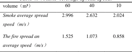
Table 4: Volume- Average Spread Speed:
volume(m³) 60 40 10
Smoke average spread
speed(m/s)
2.996 2.632 2.024
The fire spread an
average speed(m/s)
1.525 1.073 0.858
When volume narrowed, the ventilated condition become weak ( Ventilated condition also influenced by open direction, the surrounding environment, terrain, the wind Angle projection), the wind speed decreases within buildings, and when the wind speed increases in a certain range, the rate of fire fuel surface increases. volume change within scope affects temperature is not big, this won't cause temperature impact on the spread speed. So the fire spread speed in simulation slightly higher than the range of miniature burning LABS is normal.
6. CONCLUSION
Fire-fighting is an important part of urban emergency, which has a great impact on the property, security and social stability. This paper proposes a fire data management based on HGML, which is applied to the fire rescue command simulation system. G/S mode as the platform, HGML as the standard of data organization and management, the system synthetically use GIS, GPS, MIS, VR and other modern technology to hierarchically manage and comprehensively analyse the multi-source heterogeneous data distributed in various departments, through organic organization
and management of the building attribute data, spatial data, fire field sensing data. Combining fire spread model for mathematical calculations and getting a deduction resulting data, the system can perform the whole process of fire command through 3 d simulation. Based on the status quo, the industry data dispersed autonomous managed, this paper uses HGML as the data exchange standard, which can maximize the efficiency in data organization and management. The system has an important demonstration significance in the city emergency, which deserves further research and popularized.
ACKNOWLEDGEMENTS
This work was supported in part by National Natural Science Foundation of China.
Nos. 61071121.
REFERENCES:
[1] Le Chung Tran , “Space-Time-Frequency Code implementation in MB-OFDM UWB communications: Design criteria and performance”, IEEE Transactions on Wireless Communications, Vol. 8, No. 2, 2010, pp. 701-713.
[2] Songjie Li, Shujing Wang, Xinghua Li, “The Development of Jingdezhen in the View of Cultural Innovation”, Studies in Sociology of Science, Vol. 3, No. 4, 2012, pp. 45-49.
[3] Jing Yuan, Maria Elektorowicz, Tadeusz Dabros, “3D Field-Scale Environmental Multimedia System Validation of the Dispersion of Benzene for Trail Road Landfill Site and Its Risk Assessment”, Journal of Environmental Protection, Vol. 3, No. 1, 2012, pp. 41-48.
[4] Fajri Vidian, Hery Prabowo, Yulianto, “Simulasi dan Eksperimental Isothermal Aliran Eksternal Resirkulasi pada Up-Draft Gasifier”, Jurnal Teknik Mesin, Vol. 13, No. 1, 2011, pp. 7-12. [5] Xin Bai, Dana Fusco, “Interdisciplinary
Collaboration through Designing 3D Simulation Case Studies”, International Journal of Multimedia & Its Applications, Vol. 3, No. 1, 2011, pp. 101-109.
[image:8.612.88.301.322.407.2]342 [7] Thanyawat Pothisiri, Nattawut Hemathulin, “Test
Data on Intumescent Fire Protection for Structural Steel Sections in Thailand”,
Engineering Journal, Vol. 16, No. 2, 2012, pp. 85-92.
[8] Laura LIIBERT, Andreas TREU, Pille MEIER, “The Fixation of New Alternative Wood Protection Systems by Means of Oil Treatment”, Materials Science, Vol. 17, No. 4, 2011, pp. 402-406.
[9] Dayse Duarte, “An Overview about the Fire Risk Management Culture in the Brazilian Utilities”, Management Science and Engineering, Vol. 5, No. 2, 2011, pp. 76-84. [10] Poonam Tanwar, B.S. Tanwar, “Boiler Furnace
Pressure Excursion and Set Points”,