NATURAL RESOURCES
LAND MANAGEMENT
technical information to personnel concerned with the protection and management of Natural Resources at Department of Defense installations:
Forest Management-TM 5-631, AFM 126-3, and NAVFAC MO-100.2 Fish and Wildlife Management-TM 5-633, AFM 126-4, and NAVFAC MO-100.3
Outdoor Recreation and Cultural Values-TM 5-635, AFM 126-5, and NAVFAC MO-100.4 Advice concerning any procedure within this manual may be obtained from:
a. Department of the Army-Office of the Chief of Engineers (DAEN-MPO-B) b. Department of the Air Force-Directorate of Engineering and Services AFILEEV c. Department of the Navy-Naval Facilities Engineering Command (2042), or its Geographic Engineering Field Division (243).
TECHNICAL MANUAL DEPARTMENT OF THE ARMY,
No. 5-630 THE AIR FORCE, AND THE NAVY.
AIR FORCE MANUAL WASHINGTON, DC, 1July 1982
NO.126-2
NAVFAC MO-100-1
NATURAL RESOURCES LAND MANAGEMENT
Table of Contents PART I. GENERAL
Paragraph Page
CHAPTER 1. INTRODUCTION
Purpose ... 1-1 1-1 Scope ... 1-2 1-1 Environmental Considerations ... 1-3 1-1 Proponent and User Comments... 1-4 1-1
CHAPTER 2. NATURAL RESOURCES MANAGEMENT PROGRAM
Definition ... 2-1 2-1 Objectives... 2-2 2-1 Responsibilities ... 2-3 2-1 Supervision and Staffing ... 2-4 2-1 Technical Assistance ... 2-5 2-1 Classification of Grounds ... 2-6 2-2 Multiple Use... 2-7 2-3
CHAPTER 3. NATURAL RESOURCES MANAGEMENT PLANS
Long Range Planning... 3-1 3-1 Annual Increments/Work Plans ... 3-2 3-1 Records and Reports ... 3-3 3-1
CHAFTER 4. CLIMATE
Factors Affecting Plants ... 4-1 4-1 Climatic Regions ... 4-2 4-2 Precipitation Effect on Land Management ... 4-3 4-5 Temperature Effect on Land Management ... 4-4 4-6
CHAPTER 5. SOILS
Evaluation of Soil... 5-1 5-1 Soil Depth... 5-2 5-1 Texture of Soil ... 5-3 5-2 Fertility of Soil... 5-4 5-2 Soil Surveys and Land Use Capabilities... 5-5 5-4
CHAPTER 6. DRAINAGE
Importance and Factors of Drainage... 6-1 6-1 Watershed Improvement ... 6-2 6-1 Drainage Systems ... 6-3 6-1 Design and Construction ... 6-4 6-2 Maintenance... 6-5 6-2
Paragraph Page
CHAPTER 7. SOIL EROSION
Water Erosion Control ... 7-1 7-1 Wind Erosion and Dust Control ... 7-2 7-1 Shoreline Stabilization... 7-3 7-10 Sand Dune Control... 7-4 7-11 Environmental Protection During Pre-Construction and Construction Actions ... 7-5 7-12 CHAPTER 8. FERTILIZERS AN AMENDMENTS
Nutrient Requirements of Plants ... 8-1 8-1 Fertilizers... 8-2 8-1 Soil Amendments ... 8-3 8-5 CHAPTER 9. INSECTS DISEASE AND ANIMAL PESTS OF VEGETATION
General... 9-1 9-1 Insects ... 9-2 9-1 Diseases... 9-3 9-1 Animal Pests ... 9-4 9-3 CHAPTER 10. FIRE PROTECTION ON MILITARY LANDS
Fire Prevention ... 10-1 1-1 Preparedness or Presuppression Activities ... 10-2 10-1 Fire Suppression ... 10-3 10-21 Fire Reports... 10-4 10-29 CHAPTER 11. VEGETATION CONTROL
Weed Types and Situations ... 11-1 11-1 Cultural Practices ... 11-2 11-2 Herbicides ... 11-3 11-3 Plant Growth Retardants ... 11-4 11-6 CHAPTER 12. EQUIPMENT
Requirements ... 12-1 12-1 Care of Equipment ... 12-2 12-9 CHAPTER 13. POLLUTANTS AFFECTING PLANTS
Definition ... 13-1 13-1 Soil, Water and Foliar Pollutants ... 13-2 13-1 Air Pollutants ... 13-3 13-3 CHAPTER 14. SAFETY
Management and Administration ... 14-1 14-1 Health and Environment... 14-2 14-1 Protective Clothing and Equipment ... 14-3 14-1 Pesticides ... 14-4 14-1 Poisonous Plants... 14-5 14-2 Equipment ... 14-6 14-3
PART II. LAND MANAGEMENT AND GROUNDS MAINTENANCE
CHAPTER 15. ESTABLISHMENT AND MAINTENANCE OF GROUNDS
General Provisions ... 15-1 15-1 Critical Plant and Animal Habitats ... 15-2 15-1 Special Interest Areas ... 15-3 15-1 Preventive Maintenance... 15-4 15-1 Grasses and Legumes ... 15-5 15-2 Trees, Shrubs, Ground Covers and Vines ... 15-6 15-26 Golf Course Maintenance... 15-7 15-45 Airfield Maintenance... 15-8 15-47 Roadside Vegetation ... 15-9 15-47 Maintenance of Antenna Facilities ... 15-10 15-48 Magazines (Earth Covered) Maintenance... 15-11 15-50 Reclamation of Drastically Disturbed Areas ... 15-12 15-51 Mowing ... 15-13 15-56
ii
Introduction ... 16-1 16-1 Water Source Alternatives ... 16-2 16-2 Determination of Irrigation Requirements ... 16-3 16-4 Distribution Selection Alternatives... 16-4 16-5 Distribution Design for Piped Systems ... 16-5 16-6 System Operations... 16-6 16-7 CHAPTER 17. OUTLEASES AND SERVICE CONTRACT AREAS
Agricultural Leases... 17-1 17-1 Maintenance Service Contracts ... 17-2 17-1 APPENDIX A. References ... A-1 APPENDIX B. Natural Resources Management Plan, Outline for Part I-General ... B-1 APPENDIX C. Natural Resources Management Plan, Outline for Part II-Land Management and
Grounds Maintenance ... C-1 Annex I-Landscape Planting Plan ...
Annex II-Annual Work Plan ...
APPENDIX D. Technical Assistance ... D-1 APPENDIX E. Bibliography... E-1 APPENDIX F. Sample Agreement for Fire Suppression Service and Equipment... F-1 APPENDIX G. Example of Cooperative Agreement ... G-1 APPENDIX H. Natural Resources Fire Protection Plan ... H-1 APPENDIX I. Woodland and Grass Fire Report, DA Form 3985 (Sample) ... I-1 APPENDIX J. Hydro-Mulching ... J-1 APPENDIX K. Specification Guidelines for Hydro-Mulching... K-1
INDEX ... Index-1
LIST OF ILLUSTRATIONS
Figure Title Page
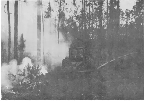
4-1 Climatic Regions of Continental USA... 4-4 4-2 Warm Season Precipitation ... 4-6 4-3 Frost-Free Days ... 4-7 5-1 Soil Auger and Soil Tube ... 5-1 5-2 Classification of Soil ... 5-2 5-3 The pH Scale ... 5-4 7-1 Sediment Basin on a Construction Site... 7-1 7-2 Method of Preserving Trees When Grade is Raised (with dry well) ... 7-18 7-3 Method of Preserving Trees When Grade is Raised (without dry well) ... 7-18 7-4 Method of Preserving Trees When Grade is Lowered... 7-18 10-1 Fir Lookout Tower ... 10-2 10-2 Firefinder ... 10-3 10-3 Fire Protection Grid Map ... 10-4 10-4 Fire Locator Grid ... 10-5 10-5 Locating a Fire at Intersection of Readings... 10-6 10-6 Prescribed Burning in Progress ... 10-7 10-7 Backfire Technique ... 10-9 10-8 Strip-Head Fire Technique ... 10-10
Figure Title Page
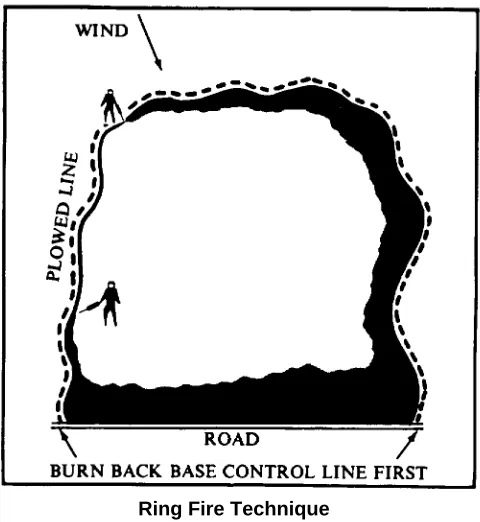
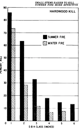
10-9 Ring Fire Technique... 10-11 10-10 Hardwood Kill Comparison (summer vs. winter fire) ... 10-12 10-11 Fire-Line Construction Using Heavy Fir-Line Plow... 10-13 10-12 Vegetated Firebreak with Rock Surfaced Patrol Road ... 10-14 10-13 Loading Light Tractor with Fire Plow Attached... 10-15 10-14 Fire-Fighting Equipment on Transport Tilt Bed Trailer... 10-16 10-15 Hand Tools in General Use for Forest and Grass-Fire Suppression ... 10-18 10-16 Testing Water Bucket of Chinook Helicopter ... 10-20 10-17 The Fire Triangle... 10-21 10-18 Breaking the Fire Triangle... 10-22 10-19 Hillside Fire-Line Construction Designed to Stop Rolling Embers ... 10-22 10-20 Small Fire Tactics ... 10-23 10-21 Tactics When Only One Tractor-Plow Unit is Available ... 10-23 10-22 Tactics When Two Tractor Plow Units are Available ... 10-24 10-23 Alternate Tactics for Use of Two Tractor-Plow Units ... 10-24 10-24 Hand-Tool Tactics ... 10-26 10-25 Good and Bad Backfiring ... 10-28 15-1 Zones of Adaptation for Grasses (1-18)... 15-15 15-2 Planting Zones for Grasses ... 15-26 15-3 Zones for Windbreak and Landscape Plantings ... 15-28 15-4 Removing a Limb ... 15-44 15-5 Bark Tracing of Abrasion on Trunk of Tree ... 15-44 15-6 Sanitary Landfill with Topsoil Replaced and Revegetated as Fill is Completed... 15-51 16-1 A Permanent Irrigation System in Operation... 16-2
List of Tables
Figure Title Page
7-1 Organic Mulches ... 7-3 7-2 Inorganic Mulches ... 7-8 9-1 Effective Fungicides for Disease Control in Landscape Planting... 9-3 10-1 Rates of Drill Sowing on Suitable Sites by Species and Climate... 10-8 10-2 List of Fire Tools/Supplies for Use with Tractor-Plow on Wildland Fires ... 10-19 10-3 List of Fire Tools/Supplies for Use by Handline Crews on Wildland Fires ... 10-19 11-1 Effective Herbicides for Landscape Planting ... 11-3 11-2 Effective Herbicides for Edging and Spot Sterilization... 11-5 12-1 Suggested List of Grounds Maintenance Equipment... 12-1 12-2 Payback Period ... 12-9 12-3 Figuring Mowing Costs... 12-9 12-4 Oil Classifications... 12-12 13-1 Tolerance of Some Plants to Salt and Salt Spray... 13-1 14-1 Some Selected Poisonous Plants ... 14-1 15-1 Seeding Rate Table ... 15-4 15-2 Spacing of Trees and Shrubs ... 15-27 15-3 Ground Cover Plants... 15-35 16-1 Water Holding Capabilities and Infiltration Rates of Various Soil Textures ... 16-4
B-1 Inventory of Land Use ... B-2
PART I. GENERAL CHAPTER 1. INTRODUCTION
1-1. Purpose. This manual provides technical
information for personnel engaged in land management and grounds maintenance on Department of Defense installations. It consolidates and modernizes criteria which were in each of the military service natural resources management and maintenance manuals. Properly applied, the principles and practices prescribed in this manual will supplement ongoing management efforts, conserve the natural resources on Department of Defense lands, maintain and improve the appearance of grounds and promote operational safety and efficiency.
1-2. Scope. This manual deals with frequent problems
regarding the conservation and management of natural resources under Department of Defense jurisdiction, world wide. Installations and facilities outside United States and its possessions will coordinate management and maintenance activities with the host country. The manual also provides soil, climate and cultural information relating to land management and grounds maintenance. It provides plant adaptability lists for the major plant growth regions of continental US. It discusses techniques for natural resources management
under a wide range of conditions, including measures for wind and water erosion control, vegetative insect and disease control, weed control and drainage improvement. Included are: bibliography; relevant references, common and scientific names of plants adaptable to Department of Defense lands; and pertinent tables and figures.
1-3. Environmental Considerations. Applicable
portions of environmental statutes, implementing regulations and Executive Orders as set forth in AR 200-1; AFR 19-2; MCO P11000.8 and OPNAV INST 6240.3E (app. A, No. 1) will be compiled with.
1-4. Proponent and User Comments. The proponent
agency of this manual is the Office of the Chief of Engineers, Department of the Army. Users are invited to send comments and suggested improvements on DA Form 2028 (Recommended Changes to Publications and Blank Forms) to HQDA (DAEN-MPO-B) WASH DC 20314.
CHAPTER 2.
NATURAL RESOURCES MANAGEMENT PROGRAM
2-1. Definition. Natural resources management is the
program for development, improvement, maintenance and conservation of the real property of DOD installations. Application includes control measures for: wind and water erosion and sedimentation; insects and diseases harmful to vegetation; excessive and undesirable vegetation; fire hazards and pollution. Maintenance and improvement practices include: care and development of turf and landscape trees and shrubs; agricultural outlease areas; soil stabilization; irrigation; land drainage; and natural resources management plans.
2-2. Objectives.
2-2.1. Conserve, develop, manage and maintain all land (includes soil, ground cover, and water areas) under DOD jurisdiction in accordance with proven scientific methods, procedures and techniques to facilitate military missions and operations.
2-2.2. Protect land investments from depreciation by adopting land use practices based upon soil capabilities.
2-2.3. Remove or screen unsightly debris or landscape blemishes.
2-2.4. Prevent installations from contributing to pollution through waste disposal or erosional debris.
2-2.5. Improve the appearance of installations and facilities through the preservation of the natural terrain and vegetation and by appropriate new plantings.
2-2.6. Prevent damage or destruction of valuable natural resources through fire or misuse.
2-3. Responsibilities.
2-3.1. Commanders at all levels are responsible for the conservation, improvement and management of all natural resources under their jurisdiction.
2-3.2 Major responsibilities of the military services, major commands and installation commanders are included in applicable directives of each of the military services.
2-4. Supervision and Staffing.
Many problems in the management of natural resources require special knowledge and technical skills. Technical guidance necessary to implement DOD policies for the
management of nature resources is provided by staffing with professional personnel to supervise the various program elements. The number and discipline of installation personnel will be dependent upon the scope of programs. Criteria for supervision and staffing are included in applicable directives of each of the military services.
2-5. Technical Assistance.
2-5.1. A valuable source of assistance is provided by specialists from major command headquarters and support commands. Such guidance involves policies, standards, procedures and periodic on-site advice in resolving technical problems and in establishing goals to implement management plans.
2-5.2. Periodic consultation with specialists in related disciplines is essential to resolve specific problems. The following specialists are most frequently needed:
2-5.2.1. Agronomists (grounds maintenance and
management).
2-5.2.2. Agricultural engineers and hydrologists (topography, drainage and flood control).
2-5.2.3. Soil conservationists (soil interpretation and conservation measures for wind and water erosion control).
2-5.2.4. State and country extension specialists (pasture and agricultural crop recommendations). Note: Several of the following specialists are employed by the agricultural extension service.
2-5.25. Land appraisers (agricultural outleases).
2-5.2.6. Turf specialists (lawns, athletic fields and golf course maintenance).
2-5.2.7 Golf course architects (design and installation).
2-5.2.8. Landscape architects (design and planting plans).
2-5.2.9. Horticulturists (selection, culture and manage-ment of ornamanage-mental plants).
2-52.10. Foresters (forest management).
2-5.2.11. Tree surgeons (pruning and repair of injuries).
2-5.2.12. Biologists (plant, fish and wildlife manage-ment).
2-5.2.13. Entomologists (insect identification and control).
2-5.2.14. Plant pathologists (identification and control of diseases).
2-5.2.15. Herbicide specialists (control of weeds).
2-5.2.16. Equipment specialists (selection and operation).
2-5.2.17. Community planners and site planners (overall planning)
2-5.3. Supplementary assistance is generally available from appropriate natural resources management agencies (Federal, State, or County). This assistance is commonly available through memoranda of understanding at the DOD level and cooperative agreements at the installation level. Criteria for memoranda of understanding and cooperative agreements are included in applicable directives of each of the military services. Specific areas of major assistance available are as follows:
2-5.3.1. Federal Agencies
2-5.3.1.1 US Department of Agriculture. The 27 March, 1963 Memorandum of Understanding between DOD and USDA provides for the development of cooperative agreements between military installations and the Soil Conservation Service, Forest Service, or Agricultural Research Service of the USDA. The objective is to promote effective planning and application of a practical soil, water, forest and plant conservation program on DOD lands. Cooperative agreements can be developed with the Soil Conservation Service through the State Soil Conservationist for; soil surveys, land use capability classifications, range surveys, and on-site assistance in developing soil and water conservation plans. Agreements developed with the Forest Service through their regional foresters can provide assistance in forest management and windbreak plantings. The Agricultural Research Service can be called on to inaugurate research studies on unsolved problems and may assist in testing the research findings at the military installation involved.
2-5.3.1.2. US Department of the Interior. Assistance can be obtained from specific divisions of this department:
2-5.3.1.2.1. Fish and Wildlife Service-guidance in management of fish and wildlife, including animal damage control, bird strike hazards and protection of critical habitat for threatened and endangered species of
flora and fauna.
2-5.3.1.2.2. National Park Service-park and recreational planning and scenic enhancement.
2-5.3.1.2.3. Bureau of Land Management-irrigation criteria, land economics, grazing land data, alkaline-saline soils management.
2-5.3.1.2.4. Heritage Conservation and Recreation Service--management and maintenance of outdoor recreation resources and historic and other unique sites.
2-5.3.1.3. The National Weather Service and US Geologic Survey have pertinent data for each military installation.
2-5.3.2. State Agencies. Technical assistance is available from a number of state agencies. The principle ones involving land management considerations are Agricultural Experiment Stations, Extension Service, Land Grant Colleges, and Departments of Conservation and Natural Resources. The technical specialists employed by these agencies include: plant disease and insect specialists, authorities on crop varieties and culture, seed analysts, soil scientists, fertilizer technologists, and drainage and irrigation engineers. Many bulletins and other published material are obtainable through these agencies. On-site technical assistance can often be obtained from them too.
2-5.3.3. Private Industry. Private industry has developed valuable information on the products they produce and sell. Their publications describe their products and prescribe their best use and limitations. Some companies provide free consultation to their users. Commercial consulting firms can be hired to do specific jobs such as golf course design, irrigation design, soil stabilization and drainage, forest timber cruising and stand improvement, reforestation, aerial fertilization, seeding and weed control.
2-6. Classification of Grounds. Grounds consist of all
annually as fixed requirements. Included are areas within the built up section of an installation which contain lawns and landscape plants; parade grounds; drill fields; athletic facilities; cemeteries; golf courses (excluding roughs); and similar areas. Maintenance operations include mowing, irrigating, fertilizing, cultivating, aerifying, seeding, sodding, spraying, pruning, trimming, weed control, vegetative insect and disease control, planting for landscape effect, wind and sound abatement and other intensive practices.
2-6.2. Semi-improved Grounds. This category includes areas on which periodic recurring maintenance is performed but to a lesser degree than on improved grounds. Included are small arms ranges, antenna facilities, picnic areas, mowed road shoulders, golf course roughs, ammunition storage areas, airfield shoulders and clear zones, drop zones, firebreaks, and similar areas. Practices normally include such cyclic variables as soil sterilization, weed and brush control, erosion and dust control, drainage maintenance, and mowing for fire protection.
2-6.3. Unimproved Grounds. This category includes all other acreage not classified as improved or semi-improved. Included are bombing and gunnery areas; impact areas, training and maneuver areas; forest areas; agricultural and grazing lands, lakes, ponds and swamps; beach and similar areas requiring limited or no maintenance. Practices and intervals of attention are generally unpredictable such as might evolve from the military mission; soil, water and wildlife conservation, floods, fires, and insect or disease epidemics. There are often the most extensive land areas under military control and generally afford the greatest potential for the development of a natural resources management
program.
2-7. Multiple Use. Department of Defense has an
obligation to the American people to act responsibly and effectively in the use of natural resources under military control. Multiple land use will be applied to the extent compatible with the military mission; to that end, the implementation of a natural resources program and the military mission need not and shall not be mutually exclusive. Use requirements for military land will be established in coordination with the installation master plan and as supported by the approved installation natural resources management. plan. The designated use of the installation land dictates the intensity of management and the applicable principles and practices for environmental protection, natural resource conserva-tion, pollution abatement and waste disposal, controlled public access for recreational uses, and for visual enhancement. The military mission determines the primary land use. Examples of multiple land use are:
2-7.1. Grazing ammunition storage areas which provides fire protection while reducing maintenance costs.
2-7.2. Erosion control plantings on slopes exposed to military personnel, or the public, utilizing plants which improve the appearance of the installation.
2-7.3. Impoundments for water supply, or flood control, and stocked with fish to provide recreational benefits.
2-7.4. Forest lands which provide maneuver areas and wildlife food and cover while producing timber products.
2-7.5. Agricultural outlease of buffer areas which provide income and benefits to the Government while providing safety zones.
CHAPTER 3. NATURAL RESOURCES
MANAGEMENT PLANS
3-1. Long Range Planning
3-1.1. A prerequisite to the management and mainte-nance program is the development and implementation of a natural resources management plan.
3-1.2. The natural resources management plan will include the following parts, as applicable: Part I-General, and Part II-Land Management and Grounds Maintenance, including an annex for the Landscape Planting Plan; Part III, Forest Management; Part IV, Fish and Wildlife Management; and Part V, Outdoor Recreation and Cultural Values. See appendixes B and C for outlines for Parts I and II. Outlines for Parts III, IV, and V are contained in publications at appendix A, no. 3, no. 4, and no. 5, respectively. The plan is organized around the military mission requirements for land and an inventory classification of the installation land area (Improved, semi-improved and unimproved grounds*). Grounds classification may be refined to address management alternatives and objectives for implementing a natural resources program. The resources include intensively used grounds; areas available for agricultural or grazing purposes; economically productive forest land; fish and wildlife management areas; and outdoor recreation and cultural resources. The plan will include an environmental assessment.
3-2. Annual Increments/Work Plans. Segments of the
natural resources management plan are to be scheduled for implementation each year. Projects to be undertaken
are set forth in annual work plans. This work involves special projects and high priority items outlined in the long range plan, all major recurring work and revisions necessitated by operational changes of the installation, required repairs caused by unpredictable weather, fire or other factors. The annual work plans must be prepared in advance of the fiscal year in which the work. is scheduled to assure adequate supplies, materials, equipment, manpower and funds. The annual work plans will be coordinated with the installation master plan for land utilization; with the installation conservation and beautification committee; and with cooperative agreements formalized with Federal, State and local natural resources conservation agencies. The annual work plans will be prepared utilizing guidelines contained in applicable directives of each of the military services. (See annex II to app. C for annual work plan format).
3-3. Records and Reports. Specific requirements for
record keeping will be governed by directives issued by each of the military services. Annual plans and accomplishments (ref para 3-2 above) are prime sources of records and data for essential reports. Accomplishments include projects completed, supplies and materials used, costs, monetary benefits from forest product sales and from outleased lands, and personnel training and safety programs specific to natural resources management.
* Forest land areas are included with unimproved grounds.
CHAPTER 4. CLIMATE
4-1. Factors Affecting Plants. Climate is a major factor
in determining the species of plants that can be grown. The plant kingdom has become adapted to a wide range of temperatures, precipitation, light exposure, day length and wind. Each of these climatic factors is extremely important in selecting plants to tolerate particular local situations.
4-1.1. Temperature. Temperature influences every chemical and physical process connected with plants and limits to a considerable extent the distribution of plants. Many plants can survive great extremes of temperature by entering resting stages. The temperature range within which growth takes place is much more limited.
4-1.1.1. Temperatures that cause the highest growth rate are not necessarily the most favorable for the general welfare of the plant. Too rapid growth may cause plants to be structurally weak, irregularly shaped, susceptible to disease or insect attack and subject to damage by wind, hail or other adverse climatic influences.
4-1.1.2. Low temperature not only slows growth but when the temperature drops below freezing, plants are in danger of frost injury. Plants survive in cold regions in a number of ways. Annuals survive by completing their life cycle and producing seed during the frost free period. Herbaceous perennials die back to the ground but maintain life in underground organs such as bulbs, tubers, fleshy roots and underground stems called rhizomes. New shoots arise each spring to form new tops. Cold susceptible plants can be benefited by mulching with poruous material.
4-1.1.3. Hardy plants tolerate cold by going dormant. The degree of cold tolerance varies with different species and varieties.
4-1.1.4. High temperatures may adversely affect plant growth. High temperatures are usually accompanied by high light intensity and rapid transpiration. When temperatures are above optimum for a species, growth slows and the plant becomes dwarfed. Excessively high temperatures may cause injury and death to areas on leaves, and cause discoloration and imperfections in flowers of ornamentals. General effects of excessive heat are leaf loss, premature dropping of fruits, and in extreme cases, death of the plant.
4-1.2. Water. Water is a necessity for growth of any
plant. Plants fall into three groups on the basis of the moisture condition to which they are adapted. These groups are: Hydrophytes-water dependent plants; Mesophytes-plants adapted to medium moisture conditions; and Xerophytes-plants which survive only under conditions of extreme moisture shortage.
4-1.2.1. Hydrophytes may grow in or under water. They can survive with the minimum of oxygen, but require an abundance of water at all times. Examples are cattails and water lilies.
4-1.2.2. The mesophytes require moderate soil moisture and a good supply of oxygen in the soil for normal development. They have moderately large root systems in proportion to the tops. Structurally they are fairly well protected against water loss through the tissues, therefore are able to make good use of the water which is available to them. Examples are oak trees, roses and bluegrass.
4-1.2.3. Xerophytes are plants highly resistant to drought conditions, having structures which reduce water loss to a minimum. Their leaves are small, with surface coverings which are thick and covered with waxy material. Such plants usually have large root systems in relation to the tops. Slow growing, they survive long periods of drought. Such plants are commonly found in the arid regions (deserts) where there is very limited rainfall at infrequent intervals. Plants in this group produce some feed for livestock and wildlife and are important in reducing soil erosion. Examples are cacti and sagebrush.
4-1.3. Light. Light has a significant effect on plant growth through most of a plants life cycle. The presence of light decreases and the absence of light increases the rate of stem elongation. If the light intensity is high the stems are short and sturdy, if low, the stems are often long and thin. Shade tolerant species respond less to low light intensities so retain their compactness far better than sun-loving species. Light is required in the manufacture of food by the plant for growth, flowering, and fruiting.
Insufficient light limits food production and storage.
4-1.3.1. Plants vary in their response to day length as well as to the light intensity. Plants which grow vegetatively during the long days of summer, and flower or go dormant in the short days, are called short-day plants. Others, just the opposite, are called long-day plants. Some are not sensitive to the lengths of day and night. Sensitivity to the relative length of day often varies among several varieties of the same kind of plant. An example is the chrysanthemum in which different varieties have different day length requirements.
4-1.3.2. Plants are sensitive to the quality and intensity of the light received while they are growing. Most plants grow best when in sunlight or partial sunlight where they may have the complete solar spectrum rather than a portion of it. Thus light intensity under natural conditions affects principally the type of growth and the amount of food the plant is able to produce for its use or for storage. Light intensity can be regulated to some degree by the location of the plant, such as the north or south exposure, or under partial shade. Select plants best suited for the amount and intensity of light to which they will be exposed.
4-1.4. Wind. Wind increases the water requirement of plants and reduces the effectiveness of rainfall. High winds can ruin crops, uproot trees, cause severe breakage, and may carry salt spray far inland causing defoliation and often death. High winds can expose root systems and redeposit the soil onto other plants. Winds are important in pollination, however, and carry fresh air to and through dense vegetation and reduce the amount of disease.
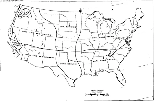
4-2. Climatic Regions. Discussion of management and
maintenance practices in this manual will relate to 10 of the climatic regions in the Northern Hemisphere: Cool humid; warm humid; cool subhumid; warm subhumid; cool arid and semiarid; warm arid and semiarid; dry summer; rain forest; arctic and subartic; and savanna. Distribution of the first seven regions in the continental United States is shown in figure 4-1. Relation of the regions to climatic adaptations of plants is not always definite, for some plants can be grown far beyond the normal regional limit adaptation because of a tolerance to variations in temperature, moisture, and soil. Temperature and moisture are the major climatic factors in soil and plant relationships in all regions. Since in many instances natural rainfall can be supplemented by irrigation, temperature may be considered of greater importance in connection with improved grounds treatment. The following characteri-zations of climatic
regions are limited to temperature, precipitation, and a few general remarks on vegetation.
4-2.1. Regions within Continental United States.
4-2.1.1. Cool humid. The northeast region of Continental United States has frequent rains during the warm season, sufficient for vigorous growth of grasses and grains. Annual precipitation for most of the area is in excess of 30 inches, with 15 to 25 inches falling from April to September, inclusive. The region in the Pacific Northwest is also cool and humid but precipitation occurs principally during the winter. The summer is relatively dry. Winter temperatures are mild so grass grows during the humid portions of the year. The frost-free period varies from less than 120 days on the northern border to about 200 days in the southern sector.
4-2.1.2. Warm humid. This region occupies the
southeastern portion of Continental United States and has an annual rainfall of 35 to 60 inches. The moisture supply is generally adequate for growth of plants in all seasons and growth is controlled primarily by the length of the warm season suitable for southern plants. The frost-free period ranges form 180 days on the northern side of the region to more than 300 days on the Gulf Coast.
4-2.1.3. Cool subhumid This region includes the northern plains region from Kansas and Colorado to Canada, and the Palouse areas of eastern Washington, Oregon, and adjoining section of Idaho. Annual rainfall of the region ranges from 15 to 25 inches. More than half of this rainfall occurs during the growing season. The frost-free period varies from 100 to 180 days. In the Palouse area rains usually occur in winter and early spring and perennial grasses grow during the warm season on moisture accumulated in the soil during the rainy season. Since the dependability of average rainfall is much lower than in the humid regions, plants must be chosen that are capable of surving extended periods of dry weather. Under irrigation all of the grasses suited to the cool humid region flourish in the subhumid areas since temperature ranges are similar in both areas.
higher average temperatures and greater losses of moisture by evaporation. Annual rainfall varies from 15 to 30 inches and 50 percent or more of this occurs from April to September, inclusive. The length of the growing season varies from 180 to 200 days. Periodic droughts occur more frequently than in other areas to the north and east; hence, more careful planning and accurate timing of operations are required in establishing perennial plantings.
4-2.1.5. Cool arid and semiarid. The cooler section of the arid and semi-arid region of Continental United States averages 5 to 20 inches of precipitation yearly. In much of this area, at least half of this moisture falls during the cool months of the year and on permeable soils it may be absorbed and retained for utilization by growing plants. Although the atmosphere is prevailing dry, evaporation rates are much lower than in southern regions with similar rainfall.
4-2.1.6. Warm arid and semiarid. Annual precipitation in this region ranges from 5 to 20 inches, but high evaporation rates reduce the effectiveness of that portion of the rainfall occurring during the warm months. Thus, winter precipitation is the principal source of moisture for growth of native species, and vegatation becomes dormant after soil moisture is exhausted in spring and summer.
4-2.1.7. Dry summer. This climate occurs in the coastal area of southern California. It is distinguished from the climate of the warm arid and semiarid region by the concentration of all rainfall in winter and early spring and by the comparatively high humidity of the air at all seasons, particularly the warm season. The climate of this area is similar to that of the Mediterranean and Near
East regions of the world.
4-2.2. Special Climatic Regions Outside Continental United States.
4-2.2.1. Superhumid. This is a tropical climate characterized by ample rainfall at all seasons and continuously warm temperatures never falling below 50 degrees Fahrenheit. The relative humidity is high and loss of moisture to the air from plants and soil is low. These continuously warm, moist conditions permit a vigorous growth of trees, climbing plants, and herbaceous plants which results in a dense ground cover.
4-2.2.2. Arctic and subarctic. The state of Alaska may be divided into three areas showing the variety of conditions encountered in this climatic region.
4-2.22.1. The interior valley of Alaska includes most of the southeastern Yukon Valley and its tributaries. The taiga forest of this area extends southward into Canada, but northward the density and size of trees decreases to a zone of scattered stunted trees intermixed with treeless tundra. The interior valley has 7 to 15 inches of precipitation fairly well distributed throughout the year. Since very little moisture is lost by evaporation, this limited precipitation supports plant growth to the extent that species are able to grow at the low prevailing temperatures. The frost-free period in the Yukon Valley is very short (60 to 90 days), although the temperature sometimes reaches 90 to 100 degrees. Winters are long and cold with temperatures averaging 10 to 20 degrees below zero.
Figure 4-1. Climatic regions of continental USA
4-2.22.2. The Alaskan Peninsula and the Aleutian Islands have an annual precipitation of 30 to 70 inches well distributed throughout the year, but somewhat lighter in the summer months. The frost-free period is variable, but may be as much as 150 days on some islands. Temperatures on the peninsula rarely rise to 70 degrees in summer or go below zero in winter. On the island chain the climate is more uniform, rarely going below 20 degrees in winter or higher than 50 degrees in summer. The predominant vegetation is tundra, composed of mosses, lichens, and sedges intermixed with low-growing grasses.
4-2.2.2.3. The knik and and muskeg areas occupy Kodiak Island and the alluvial plain extending along the eastern and northern sides of Cook inlet, including the beaches and flats along the western side of Kenai Peninsula, in the valleys of the Matanuska and Susitna rivers. Annual precipitation varies from 15 to 30 inches. Summers are short, with about 110 days of frost-free weather at Anchorage. The winters are long and cold.
Native cover consists of the true knik and muskeg areas, in which sphagnum moss alternates with open spaces occupied by grasses, and forests of spruce, hemlock, birch and aspen.
4-3. Precipitation Effect on Land Management
4-3.1. Seasonal Distribution. Total annual precipitation and gross seasonal distribution have been mentioned for each climatic region. Regional differences can be shown by comparing two stations with approximately the same total annual precipitation. Of the 15 inches at station A, 4 1/2 inches fall during the period October to April when growth is dormant. From May to September 10 1/2 inches occur when growth is active. At station B, the reverse occurs with 13 1/2 inches of precipitation during the fall and winter months and only 3 inches during the May to September period. Both stations need drought tolerant plants, but station B would have to plan for yearly irrigation.
4-3.1.1. Areas with cool summers and uniform rainfall distribution favor cool season grasses. With the same amount of rainfall but higher summer air and soil temperatures, the cool season grasses become dormant, opening the turf to invasion by weeds.
4-3.1.2. An entire season’s bloom on spring flowering shrubs may be lost if there is a shortage of moisture during flower bud formation the previous fall. Light showers along with high temperatures and wind (common in early fall) are completely ineffective in supplying moisture to plants.
4-3.1.3. Precipitation in the form of snow may require removal from plants to avoid excess breakage as it settles. Selection of plants that shed or bend with snow should be given serious consideration in the snow belts. Placement beyond the zone where snow slides from roof tops is another point to bear in mind. The above indicates a few examples of the effect of time and kind of precipitation on the land management program.
4-3.2. Duration and Intensity. Both duration and intensity of a storm affect vegetation and soils. Should it drizzle for a week most of the rain will soak into the soil. A five inch rain lasting an hour will cause run-off within a few minutes due to lack of absorptive capacity of the soil. Should it continue to rain at the 5-inch per hour rate, flooding will probably occur, making it necessary to plan for storm run-off. Intensity influences effectiveness of rainfall. Unless the rain can enter the ground it is not available for plant use. Many slopes become dry even when the amount of rain has been adequate for flat land, since the run-off from slopes materially reduces that which is available.
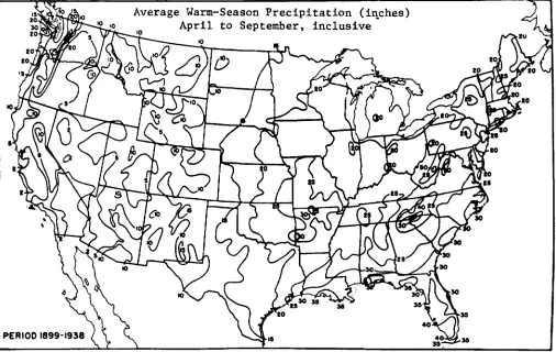
4-3.3. Seasons. There are seasons when planting should be avoided. Each installation must establish opening and closing dates for planting and seeding contracts. Rainfall pattern as well as temperature may enter into these determinations. Questions to be resolved might well be:
Is the soil moisture adequate to permit germination? Is the rainfall pattern at this time of year favorable for germination and establishment?
Is there enough soil moisture to carry new transplants through the winter months or will the plantings have to be irrigated?
Which season is the best for any given species? Figure 4-2 gives the warm season precipitation for the Continental United States. The U. S. Department of Agriculture Year Book for 1941 (CLIMATE AND MAN) has maps for each state. These are only guide lines and should be augmented with local data as available.
Figure 4-2.
4-4. Temperature Effect on Land Management
4-4.1. Winter Kill and Ice. Woody plants may have terminals killed back when the plants are not allowed to harden off properly. It often occurs when fertilizer is applied late in the growing season causing succulent growth to succumb to winter injury. Cold induced injury to tissues or internal structures of woody stems is common and is generally recognizable by discoloration of the affected part. "Black heart" is an extreme case of such injury in which pith and often one or more annual rings of wood will be dark colored, but not the cambium which produces new wood. Killing of the bark on trees and ornamental plants may occur at crotches, at the base of the trunk, and in patches variously located on branches and trunk. Frost cracks and splitting and loosening of bark are mechanical injuries to woody plants resulting from severe freezing.
4-4.1.1. Late spring frosts may damage or kill young tender plants. Flowers, shoots and leaves of orna-mentals may be damaged such that their esthetic value is largely lost for the season.
4-4.1.2. Sun-scald is a cold injury occuring on the south and west sides of tree trunks and branches. In cold
weather, sunlight falling directly on the bark may create temperatures several degrees higher than shaded parts. At sunset the temperature drops suddenly and killing of the bark results. Shading or wrapping the trunk to reduce absorption of heat from the winter sun reduces the sun-scald type of injury.
4-4.1.3. Some indirect effects of low winter temperatures on plants are heaving of soil, resulting in breakage or exposure of roots; the smothering effect of ice sheets; and breaking of trees and shrubs by snow and sleet.
4-4.2.1. In some species seed does not germinate unless soil temperatures are cool. To attempt summer seeding of these species is to invite failure. Some species require a warm soil temperature for maximum germination. Other species function best when there is fluctuating cool and warm, which is common in the spring and fall. The grounds manager should know the characteristics of his plants and their specific reactions.
4-4.2.2. Native plants have proven their adaptability to a given location. Exotics must be proven over a period of years. Too often a warm cycle of a few years encourages the planting of non-adapted species which die when normal weather is resumed.
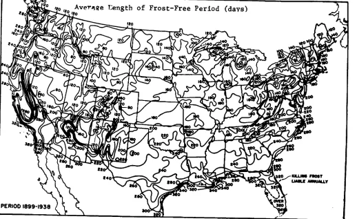
4-4.3. Growing Seasons. Growing season is usually defined as the number of days between the last killing frost in spring and the first killing frost in fall. In Hawaii there is no distinct growing season except at higher elevations. Growth is cyclic-new growth, a slow down when new buds are developed and increased activity when the new leaves emerge. On the dry sides of the islands, growth correlates to periods of rainfall. On the Pacific coast the winter growing season is also controlled by rainfall, not temperature. The number of frost-free days for Continental United States is shown in figure 4-3. More detail, by States, can be found in the 1941 Year Book of Agriculture (CLIMATE AND MAN).
Figure 4-3. FROST MAP
CHAPTER 5. SOILS
5-1. Evaluation of Soil.
5-1.1. Understanding Soil A thorough understanding of soil characteristics and conditions is important to a successful planting program. Certain qualities of soils determine their ability to support plant growth. The texture of soil determines how well it can resist erosion and how much water can be stored for plant use. The physical and chemical composition of the soil determines how well plants will grow. Requirements for soil improvement depend upon the kinds and amounts of plant nutrients available in the soil.
5-1.2. Soil Analysis. Soil characteristics are determined by soil analysis. Obtain soil surveys from the United States Department of Agriculture, where they are available. Where extensive plantings are to be made, analyze and evaluate soils for the following:
Depth of permeable soil and penetration of grass roots.
Mechanical characteristics of surface soil and subsoil.
Chemical characteristics of surface soil. Special characteristics, where applicable:
Toxic salts. Organic matter. Rate of water intake.
5-1.3. Made Land. This land type consists of areas where soil materials have been disturbed by fill or excavation. It is found in most housing and other construction areas and can be quite extensive at many military installations. Such land can no longer be identified by soil series, or as a single named soil and generally requires special treatment to establish and maintain vegetative cover.
5-2. Soil Depth.
The depth of soil is important in predicting the capability of soil to support plant growth. A minimum of two feet is desirable for plantings.
5-2.1. Determination of Soil Depth. The depth of soil may be observed in road cuts and embankments, or it may be obtained with a soil auger (fig. 5-1). Also, the penetration of grass roots indicates effective soil depth and gives the number of inches (or feet) in which water from rain or irrigation may be stored. Depth of roots should be observed at excavations recently made through typical grass areas. Deep roots indicate favorable soil structure (drainage, aeration, and texture).
5-2.2. Soil Profile. Well-developed, mature soils that have not been altered by construction or grading usually have well-defined layers called horizons which differ in color, texture, and structure. From the surface
downward, the series of horizons (A, B, and C) is called the soil profile. Some soil profiles show four feet or more of uniform dark color and texture without well-marked horizons. These soils are usually highly productive, but they may be subject to severe damage by erosion and must be protected from storm runoff. Other soils, such as those that cover impenetrable rock, shale, caliche, gravel, or hardpan, may be so shallow that they have no typical soil profile. Also, a high permanent water table or underlying coarse sand may prevent formation of a typical soil profile. On thousands of acres, soil and/or water erosion have removed all the A horizon and at
Figure 5-1. Soil auger and soil tube used to obtain samples for analysis, to locate soil layers, and to
least part of the B horizon. Grounds maintenance supervisors often have to deal with B and C horizons only.
5-2.2.1. A Horizon. Typically, the A horizon consists of the upper 6 to 12 inches of weathered soil which contains most of the organic matter. It is more subject to change than the other horizons, for the soil-forming processes are most active in the surface layer.
5-2.2.2. B Horizon. The next layer, with less weathering and less root activity, is the B horizon. It may have a less granular (more block-like) structure. The B horizon receives materials from the A horizon as a result of the downward movement of water. In humid regions it may be darker in color and more closely compacted owing to greater content of clay, iron, and aluminum compounds. In subhumid to arid regions, it usually contains more alkaline materials and salt accumulations.
5-2.2.3. C Horizon. The C horizon has only minor evidence of weathering and root residue. If the C horizon consists of impervious materials, internal drainage of the A and B horizons is seriously impeded. The principal value of the C horizon is water storage. Although plant roots are not abundant in the C horizon, the water held there can support the plant through periods of drought.
5-3. Texture of Soil.
Soil consists of fragments varying in size from coarse particles (gravel and sand), to fine particles (silt), and very fine particles (clay). Classification of soil texture is based on the relative percentages of sand, silt, and clay, which are determined by mechanical analysis. In many localities accurate estimates of sand, silt, and clay in a sample can be made by soil technicians from the U.S. Soil Conservation Service. Excessive sand may prevent soils from retaining moisture and applied fertilizers. More than 50 percent of sand or sand and gravel may cause failure of cool-season grasses, especially in the southern parts of their adapted range or where the subsoils also have excessive sand or gravel. Clay loams retain three to six times as much water for plant use as sandy soils do. Soil with high clay content may be excessively plastic and unsuitable for physical training areas without some modification. Excessive silt (40 percent or more) causes poor interior drainage and shallow root penetration.
5-3.1. Particle Sizes. Diameters in millimeters of soil and gravel particles for various sizes according to the U.S. Department of Agriculture
scheme--Gravel... 75 to 2. Very coarse sand ... 2 to 1.0. Coarse sand... 1.0 to 0.5. Medium sand... 0.5 to 0.25. Fine sand ... 0.25 to 0.10. Very fine sand ... 0.10 to 0.05.
Silt ... 0.05 to 0.002. Clay... Below 0.002.
5-3.2. Mechanical Analysis. Percentages of sand, silt, and clay are determined by mechanical analyses of soils, either by sieve tests or laboratory tests. Separate analyses may be necessary for surface soil and subsoil (A and B horizons), especially if the two horizons differ appreciably. When topsoil is to be used as a soil amendment it should be analyzed separately when texture data is required. Inquiry should be made, prior to obtaining soil samples for analysis, regarding procedure for taking samples and the preparation of samples for delivery to the laboratory.
5-3.3. Classification of Textures. Soil textures are classified and identified according to the percentage of sand, silt, and clay. As indicated in figure 5-2 a Sandy Clay Loam contains not less than 52 percent sand, not less than 20 percent clay, and not more than 28 percent silt; whereas, a Sandy Clay contains not less than 45 percent sand, not less than 35 percent clay, and not more than 20 percent silt.
Figure 5-2. Classification of soil by percentages of sand, silt, and clay.
5-4. Fertility of Soil.
acidity or alkalinty. The growth nutrients most likely to be deficient are nitrogen, phosphorus, and potash. Soil is sometimes deficient in magnesium, calcium, and iron. (See chap 8 Fertilizers and Amendments).
5-4.2. Tests for Soil Deficiences. Soils are tested to determine the substances present and the conditions which affect plant growth. Most state agricultural experiment stations will make laboratory tests upon request. These tests serve primarily as guides. The USDA Agricultural Extension Service at the county level generally provides instructions on taking and submitting soil samples to the State Agricultural Experiment Station Soil Laboratory. Containers for the soil samples are often provided. Where fees are charged for soil testing, they are nominal; particularly when considering the reports made and recommendations provided for corrective action. Testing soils at the installation, by the use of field kits, is generally not recommended. Field (plot) tests at the installation, to determine fertilizer needs for turf grasses, are generally not recommended either when such determination can be made at the soil laboratory, above cited. Plot tests involving experimental fertilizers and soil amendments, to determine adaptability to local conditions, are encouraged where professional, or spedifically trained personnel are available at the installation and when coordinated with the product manufacturer.
5-4.2.1. Tests for nitrogen. Due to the high solubility of nitrogen bearing material in the soil, laboratory tests for nitrogen are recommended only in geographic areas where tha annual preciptation is under 20 inches per year. Consult the USDA Agricultural Extension Service at the county level, for nitrogen application recommendations based upon State Agricultural experiment station test results.
5-4.2.2. Tests for phosphorus and potash. Most laboratory reports give phosphoric acid and potash in pounds per acre. The amounts of soluable rather than available nutrients are shown, as each kind of plant has a different potential for using these nutrients. Some
laboratories report soluble nutrients as low, medium, and high for phosphoric acid and potash. Reports may also be in terms of the elements, phosphorus and potassium rather than as phosphoric acid and potash. The National Soil and Fertilizer Research Committee has coordinated these ratings in pounds per acre as follows:
Substance Low Medium High Phosphoric acid 0-100 100-150 Above 150.
(P2O5).
Phosphorus (P) 0-44 44-65 Above 65. Potash K2O) 50-150 150-250 Above 250. Potassium (K) 42-124 124-208 Above 208. Several laboratories report on the basis of parts per million (ppm), which may be converted into pounds per acre by multiplying by two (for example, 40 ppm is 80 pounds per acre). Others report in terms of percentages, which may be converted into pounds by adding two decimal places and multiplying by two million (for example, 0.0025 percent is 0.000025, and this figure multiplied by 2,000,000 gives 50 pounds per acre).
5-4.2.3. Tests for magnesium and calcium. Deficiencies of both elements are very likely to occur on strongly acid soils and are generally corrected by application of dolomitic limestone for magnesium and of ground limestone for calcium.
5-4.2.4. Tests for iron. Deficiency of iron in soil may be detected by the yellowed (chlorotic) appearance of vegetation. Deficiency often occurs in sandy soils, soils that are highly calcareous (high in lime content) and soils lacking in organic matter.
5-4.2.5. Tests for alkalinity and acidity. Highly alkaline soils tend to lack structure-the soil particles merge, resist penetration of air and water, and prevent normal root development. Alkalinity and acidity of soil are expressed in terms of pH (the logarithm of the reciprocal of the hydrogen ion concentration) and are registered upward (alkaline) and downward (acid) on a numerical scale from pH 7, which indicates neutrality. (See fig 5-3).
Figure 5-3. The pH scale.
5-4.2.6. Tests for toxic salts.
5-4.2.6.1. Soils that have a pH value greater than 8.5 may have objectionable amounts of alkaline salts. Incrustation of salt on a dry soil surface and failure of plants to respond to applications of fertilizer indicate the need for a laboratory test. Laboratory tests for salt are based upon the percentage of exchangeable sodium; more than 15 percent of the exchange complex occupied by sodium is harmful to most cultivated plants. Consult the Soil Salinity Laboratory Manual (U.S. Department of Agriculture Handbook No. 60) for detailed information on this subject. In arid sections, the salt content of water used for irrigation is also important. A laboratory test of water supplies may be necessary. Difficulty in the maintenance of plant growth may be expected if soluable salts in the water exceed 1,200 parts per million.
5-4.2.6.2. Installations having toxic salt problems, in establishing or maintaining vegetative cover, should consult the USDA Agricultural Extension Service at the county or state level. Information should include recommended treatments pertaining to soil cultural practices and advice on locally adapted plants that are tolerant to the toxic conditions.
5-4.2.7. Tests for organic matter. Tests for organic
matter in soil are made by laboratory methods and the findings are expressed in percentages of dry weight. Most well-drained soils contain 5 percent or less of organic matter. Southern and desert soils tend to have lower percentages than northern or temperate-zone soils, while peat may contain more than 50 percent of organic matter. The percentage of organic matter reported by soil laboratories should not be confused with "percent organic matter" commonly reported in the construction of golf courses, which may refer to volume rather than do dryweight.
5-5. Soil Surveys and Land Use Capabilities. Soil
surveys provide for classifying, naming soil types and delineating each kind of soil. They include predictions of soil behavior under specific management. Soil surveys are made and published for designated areas such as counties, special projects, or soil conservation districts. The soils are mapped and classified without regard for existing or expected land ownership boundaries or present use. Each kind of soil has its peculiar set of characteristics and qualities which are described in terms that can be observed. These ihclude soil texture; structure; drainage factor; depth; soil horizons; organic matter content; acidity and slope; all effecting soil management.
5-5.1. Maps. Aerial photo maps are used to record the location, area and slope of each soil. The mapping is done at different degrees of intensity depending upon the uses made of the soils information. The information is assembled and published as a soil survey report. The report includes a set of soil survey maps usually on a scale of four inches to the mile and a detailed description of each soil. Results from soil laboratory analysis aid interpretation.
on limitations of soils, the risk of damage when they are used and the way they respond to treatment. The eight capability classes in the broadest grouping are designated by Roman numerals I through VIII. In class I are soils that have few limitations, the widest range of use, and the least risk of damage. The soils in the other classes have progressing greater natural limitations. Class VIII are those soils and land forms so rough, shallow or otherwise limited that they do not produce worthwhile yields of crops, forage or wood products.
5-5.3. Land Use Capability Interpretation. Land used within its capability is easily and economically maintained. Used beyond its capability it fails, requiring complete renovation. For example; some class II wet land can, after installation of a tile system, be used intensively for parade grounds or athletic fields while other wet land, in spite of tiling, will compact, puddle at the surface and severely retard infiltration of rainfall. Airfields built on soils with an impervious layer without adequate drainage become floating runways when the soil is completely saturated. Excessively drained soils, even in areas of high rainfall, will show drought damage to its vegetation unless organic matter is added, drought tolerant species planted, or irrigation provided. Land use capability classes and interpretations are very useful when preparing plans for improved grounds and agricultural outleased lands. A thorough understanding of soil capabilities and limitations are basic to sound land
use decisions and maintenance programs. Modern published soil surveys contain valuable qualitative information for engineers and earth moving contractors. The following engineering information is generally found in modern soil surveys:
5-5.3.1. General suitability for: Source of topsoil, sand and gravel; subgrade; and foundation material. 5-5.3.2. Soil-water relations: Drainage class; seasonal high water table; erosion hazard and permeability.
5-5.3.3. Special Problems: Flood hazard, wind erosion, shallow bedrock, cemented or compacted layers, stability of slopes and seepage in cuts. Standard soil surveys such as those conducted by the Soil Conservation Service (S.C.S.) U.S. Department of Agriculture, in cooperation with the state agricultural experiment stations, when accompanied by appropriate interpretations can be adapted to meet the basic soils data needs of comprehensive planning at DOD installations. The S.C.S. maintains a complete list of all soil surveys which are completed and published as well as those which are still in the process of completion. Information on the availability of soil survey data may may be obtained by writing to the State Soil Conservationist, Soil Conservation Service, in your state, or to the US Department of Agriculture, Soil Conservation Service, Soil Survey Publications Staff, Washington DC 20250.
CHAPTER 6. DRAINAGE
6-1. Importance and Factors of Drainage. Drainage is
the flow of excess water from an area by external or internal routes to a specific discharge point. Drainage is also the process of draining and the means used to dispose of excess water. Good drainage is necessary for the prevention of storm damage, landslides and flooding, for maintenance of desired vegetation, for operational safety and efficiency, and for preventing breeding places which harbor disease-transmitting insects. Principal factors involved in drainage are soil permeability, grade, and vegetative covering. Vegetative covering helps increase the rate of infiltration, decreases the runoff rate, and reduces the drainage load on disposal facilities. Reduction of runoff rate is important in the control of soil erosion. Watershed areas which contribute to storm and flood runoff may be improved by proper use of vegetative cover, construction of terraces, diversion channels, debris basins, flood gates, and the like. Maintenance of storm drainage systems includes the removal of accumulated silt, gravel and other debris along the channel flow line and at drainage structures; and the control of willow, cattail and similar vegetation which inhibit channel flow. Redesign of existing channels and the construction of new channels may be required to accommodate increased runoff from new development areas (e.g., new buildings and surfaced areas). For drainage improvements on land where soil series can be identified, land managers should utilize soil survey information prepared by the Soil Conservation Service. (See para. 5-1 and 5-5.) This soil information provides guidelines on type of drainage (surface or subsurface) suitable for a particular soil and terrain situation.
6-2. Watershed Improvement. Any consideration of a
draimage system immediately involves the watershed and its contribution to total storm runoff.
6-2.1. Objective. Watersheds can generally be improved by reducing the rate of runoff and increasing the rate of water infiltration into the soil.
6-2.2. Procedures for Watershed Improvement.
6-2.2.1. Soil conservation practices. If a watershed is unimproved grounds under military jurisdiction, use standard agricultural practices for soil conservation. Standard practices include: vegetating sparse or denuded areas to plants, including forest and wildlife
seedlings, adaptable to the soil capabilities; and constructing diversion terraces and outlet channels as appropriate. If the area is in an agricultural outlease program, specify rate of grazing and contour strip cropping where practicable. Standard practices also include fertilization and soil amendments as required.
6-2.2.2. Local cooperation. If a watershed is not under military jurisdiction, request local agencies to cooperate in introducing acceptable soil-conserving measures.
6-2.2.3. Forest lands. Where the watershed is forested and managed as such, apply practices prescribed for forests in the forest management plan.
6-2.2.4. Improved grounds. Where the watershed is improved grounds, use maximum permissible height of cut for mowed areas to decrease runoff. Vegetation cut at 3 inches will prevent rapid runoff more effectively than lower cuts. Develop effective vegetative cover by planting and fertilizing all denuded slopes, ball fields, and areas where troops concentrate. Control foot and vehicular traffic in built-up areas.
6-3. Drainage Systems. The two types of drainage
systems are surface and subsurface. Classification depends on whether water is on or below ground surface when first collected for disposal. Both systems should be closely coordinated with requirements for health and sanitation.
6-3.1. Surface Drainage. Surface drainage provides for the collection and disposal of water from the surfaces of land as well as runoff from buildings, pavements, taxiways, runways, and hardstands. Surface facilities may include existing streams, open ditches, diversion channels, terraces, and levees.
6-3.2. Subsurface Drainage. Subsurface drainage provides for the collection and removal of excess water in the subgrade. This type of drainage is also used to prevent the water table from rising to a point where it affects the stability of surfaces adjoining runways, taxiways, and hardstands. Subsurface structures include
storm sewers, catch basins, manholes, outfalls, french drains, subsurface field drains, and so forth.
6-4. Design and Construction. Land managers at
military installations are involved primarily in the maintenance of existing systems. When repair or alteration of existing systems is involved, or when new systems are required, the design and plans should be prepared by personnel trained in such work. See AFM 88-5, Chapter 4/NAVFAC DM-5/and TM 5-820-4, (app. A, no. 6). for information specific to surface and subsurface design, construction and installation.
6-5. Maintenance. Frequent inspections of the system
are required to prevent costly repairs and breakdowns at key points. The following are examples of maintenance procedures required;
6-5.1. Maintenance of Terraces. Preventive maintenance includes periodic checking of all terraced areas and outlet channels, especially after heavy rains. Repair breaks in terraces by filling, fertilizing, and planting erosion-preventive vegetation. Construct additional terraces in areas that have been inadequately terraced. Repair structures, drainage outlets, and diversion ditches when necessary, and correct conditions that have caused the failures.
6-5.2. Field Tile Maintenance. Maintain a chart showing location of lines and outlets of installed title. Use soil augers and probes to locate lines for which records are not available. Repair sections of those lines and outlets, which have failed, structurally or from corrosion, to prevent damage to other parts of the system. Indications
of failures are poor drainage after rains in some sections of the tiled area and cave-ins over the lines. Install flap covers at outlets to keep rodents out. Pay special attention to all outlets to assure that they are open and that adequate headwalls and manholes are constructed. Expose plugged lines and repair them; or, where necessary, replace by larger tile and correct the tile grade. Clean out tile lines filled with tree roots. If the trees and shrubs causing the difficulty cannot be killed or removed, replace the section with sewer tile installed with carefully mortared joints. Install relief wells in lines that tend to blow out because of higher pressure. Relief wells consist of a T-connection in the line with vertical sections of sewer pipe to the soil surface. Locate relief wells where they cannot be damaged by mowing equipment and will not interfere with athletic activities on ball fields. Protect well tops with gratings.
6-5.3. Channel Maintenance. Inspect channels after each storm. Repair and redesign overalls, chutes, drop inlets, and other structures as necessary. Provide new structures, as necessary, to carry the discharge. Enlarge channels at key points, especially where they pass under roads or railroads. Maintain channel and channel banks in vegetative cover where grades are not steep enough to require structures. Prevent woody vegetation, cattails, and similar tall growing water loving plants from becoming established. Grazing on open channel banks is permissible, except on sections that tend to erode. Avoid overgrazing.
CHAPTER 7. SOIL EROSION
7-1. Water Erosion Control. The primary object in the
control of erosion is to retard all rainfall at the point of impact so that it either soaks into the soil or is directed to well protected waterways where it flows at nonerosive speeds. Prevention and correction of soil erosion is accomplished by improving the vegetative cover and installing supporting engineering measures including vegetated diversion terrances and outlet channels.
7-1.1. Vegetative Cover. Vegetation provides an effective control of erosion for most sites. Even in most deserts and on steep slopes, vegetation is used effectively where combined with other appropriate control methods. Maintenance of areas established to vegetation includes mowing and fertilizing where necessary to develop a dense turf; use of herbicides to eliminate brush and weeds that may destroy plantings; repair of bare areas that have lost their effective cover; and construction of flumes, terraces, retaining walls or other facilities where vegetation is found to be inadequate for resisting erosion caused by storm runoff.
7-1.2. Engineering Measures. Most of the factors used in the design of engineering measures are included in chapter 6, Drainage, since soil erosion control and storm runoff control on military installations are so closely allied. (See para. 7-5 for measures relating to pre-construction and pre-construction operations. See also para. 15-12 for erosion control in drastically disturbed areas). Contact the U.S. Soil Conservation Service, local or state office, for recommendations on soil erosion control structures (e.g. diversion terraces and outlet channels).
7-2. Wind Erosion and Dust Control. Major wind
erosion problem areas are the Great Plains, the Columbia River Plains, parts of the Pacific Southwest, the Colorado Basin, the muck and sandy areas in the Great Lakes region, and the sands of the Gulf and Atlantic seaboards. The fine silt and clay particles along with light weight organic materials are picked up and blown away in dust storms. The heavier sand particles do not become air born but bounce along the soil surface in a movement called "saltation". Soil blowing adversely affects the health, safety, and morale of personnel as well as damaging facility improvements and equipment. Housing areas, airfields, firing ranges, hangars, hospitals, athletic fields, lawns, and parking lots are all
subject to damage by blowing soil and drifting sand. Sand and dust damage to technical equipment, aircraft, flight instruments and other engines results in unnecessary maintenance costs, frequent replacement of engines and parts and an increase in accidents. Dust and sand passing through a jet engine cause loss of thrust and increased fuel consumption. Airfields with thin vegetation alongside of the runways add to dust damage with every plane that takes off. Preventive rather than corrective measures are called for, especially in areas where wind erosion is known to be common. Most active sources of dust are on the installation itself. If important sources are located outside the installation, coordinate and cooperate with adjacent land owners, community groups, and state and federal agencies concerned with soil conservation.
7-2.1. Control Measures. These must encompass all wind erosion and dust problems at the installation since partial measures can lead to loss of existing treatments and create additional problems. Timely inspections, strict foot and vehicular traffic control, and compliance with a scheduled vegetation maintenance program can substantially reduce wind erosion and dust problems. Where water supply for irrigation is limited, priority of water use should be given to potential dust producing areas such as athletic fields. Training should not be permitted on areas planted for wind erosion and dust control. Pedestrian, vehicle and aircraft traffic should be controlled to prevent formation of dust producing areas. Control measures include rough tilling, vegetating, mulching, treatment with chemicals or special oils, and erecting snow fence or other mechanical barriers. See tables 7-1 and 7-2 for some appropriate products and materials. Also, dust palliative methods and materials are discussed in TM 5-830-3/AFM 88-17, Chapter 3.
7-2.1.1. Mechanical measures.
7-2.1.1.1. Rough tillage. Rough tillage is an effective temporary means of dust control. Tillage operations should be performed at right angles to the prevailing winds. The resulting rough, cloddy conditions will provide
an obstacle to the force and speed of the wind and will retard the movement of surface water following periods of intense rainfall. Rough tillage may be especially helpful at construction projects prior to establishment of vegetation. Tillage by plowing or disking is accomplished over an entire area or at regularly spaced intervals.
7-2.1.1.2. Aggregates.
7-2.1.1.2.1. Materials. In areas where rainfall is so limited that vegetation is sparse, effective dust control can be achieved by use of gravel blankets. The material should be relatively free of sand or fines. In administrative and
industrial-type areas, rock or stone, one to two inches in diameter are capable of withstanding limited foot-traffic, but vehicular traffic should be prohibited. Gravel blankets should not be used on areas subjected to propeller blast since there is danger of blowing gravel into nearby aircraft. On these and other areas of high wind velocities, well-stabilized angular stone, two inches in diameter or larger may be used. Gravel or crushed stone is not used adjacent to runways or taxiways utilized by jet aircraft or on areas subjected to blast from jet aircraft.