Thesis submitted in candidature for the degree of Doctor of Philosophy
University of Salford
by
C.B.IIERMAN EDYANTO
DEPARTMENT OF GEOGRAPHY SALFORD UNIVERSITY
1
TABLE OF CONTENTS
LISTOF FIGURES ...
vi
LISTOF TABLES ...
ACKNOWLEDGEMENTS...
xiv
ABSTRACT
xv
THE CONTENT OF THE STUDY
0.1.Objectives.
1
O.2.Data required ...
1
O.3.Techniques ...
2
O.4.Procedures...
3
0.5.Assumptions ...
3
CHAPTER I INTRODUCTION.
I.1.The coastal zone...
9
I.2.Rural areas ...
10
I.3.Definition of problem...
13
I.4.Data base...
17
I.5.Field survey...
19
I.6.The 'Kecamatan' (sub—district) in
developmentprogrammes...
20
I.7.Organizational structure: The Government
Systemin Indonesia...
24
I.8.Structure of the study...
27
CHAPTER II RURAL DEVELOPMENT STRATEGIES :
THEORETICAL FRAMEWORK.
II.1.The Growth Pole strategy...
31
II.2.The Agropolitan strategy...
37
II.3.The Spatial Integration strategy...
43
II.4.Central Place Theory...
47
II.5.Key Settlements concept...
51
II.5.1.Central ity...
55
IT.6.Indonesian rural development...
58
II.7.Conclusion.
64
CHAPTER III THE INDONESIAN GOVERNMENT'S POLICIES FOR
REGIONAL DEVELOPMENT
III.1.The Strategy for development in
Indonesia.
67
III.2.The Strategy and regionalization of
development in Central Java...
68
III.3.Policies and actions for rural
development...
77
III.4.Regional Planning Policies in Central
Java...
79
11
CHAPTER IV. THE STUDY AREA: GENERAL BACKGROUND.
IV.1.CentraI Java Province. 85
IV.2.The Importance of Coastal Rural
Development... 90
IV.3.Background to the study area 92 IV.3.1.Environmental aspects: ... 92
IV.3.1.1.Landforms. 92 IV.3.1.2.Drainage. 95 IV..3.1.3.Sedimentation... 97
IV.3.1.4.Vegetation... 98
IV.3.1.5.Geology... 99
IV.3.1.6.Rainfall ... 99
IV.3.1.7.Land use... 100
IV.3.2.Social Aspects... 102
IV.3.2.l.Demograpic: 102 IV.3.2.1.1.Population distri-bution, size, and age composition ... 103
IV.3.2.1.2.Labour force and occupations... 107
IV.3.2.2.Education... 110
IV.3.2.3.Rural Health Facilities... 115
IV.3.3.Economic aspects...118
IV.3.3.1.Agricultural activities. 118 IV.3.3.2.Transportation facilities 131 IV.3.3.3.Coastal rural industry...136
IV.3.3.4.Markets...140
CHAPTER V.BASIC CONSIDERATIONS FOR THE ASSESSMENT OF POTENTIAL FACTORS. V.1.Natural resources as factors in development... 143
V.2.Trade and markets as factors in development... 147
V.3.Human Resources as factors in development... 149
V.4.Social facilities as factors in development... 151
V.5.Transportation as a factor in development... 153
V..6.Agriculture as a factor in development... 154
V.7.Rural industry as a factor in development... 157
CHAPTER VI.ASSESSMENT OF THE SIGNIFICANCE OF THESE FACTORS FOR DEVELOPMENT IN COASTAL KECAMATANS. VI.1.Factor Analysis as a method for data processing... 161
VI.2.Criteria used to assess the significance of individual kecamatans for development 162 VI.2.1.I-iuman resource availability... 164
VI.2.2.Potential in the agricultural sector... 173
VI.2.3.Transportation facilities ... 176
111
180
184
218
224
234
236 236
246 VI.2.4.Availability of social and economic
facilities...
VI.3.Application of the model. ...
VI.4.The criteria used to assess the relative
significance of environmental factor...
VI.5.Application of the model ...
CHAPTER VIJ.EXAMINATION BY THE GUTTMAN SCALE METHOD.
VII.1.The Guttman Scale Method... VII.1.1.Application of the Guttrnan Scale
Method... VII.1.2.Variables used for Method ...
VII.2.Comparison of the results from the two
methodsof analysis ...
CHAPTER VIII.TFIE PRIORITY OF KECAMATANS AND PROPOSED PROGRAMMES FOR DEVELOPMENT
VIII.1.Priority for development based on
socio—economic,and environmental factors ...
VIII.2.Proposed programmes for individual groups
ofkecamatans...
VIII.3.The role of the market place as a physical manifestation of the commercial sector...
CHAPTER IX.IMPLEMENTATION OF DEVELOPMENT PROGRAMMES FOR SELECTED KECAMATANS
IX. 1.Option of strategies for coastal rural
development...
IX. 2.The relevance of Key Settlement policies
indeveloping countries...
IX. 3.Relationship between the Key Settlement Concept and significant factors and its relevance for development in the
kecama-tans...
IX. 4.The functions of Key Settlements : a
proposal...
IX. 5.The application of the Key Settlements
Concept...
IX. 6.The proposed settlements hierarchy...
IX. 7.Functional hierarchy of settlements, and thresholds for service units
IX. 8.Proposed population size of each level
249
262
266
269
274
277
279
283
286
iv
of Key Settlement . 293
IX. 9.Proposed distribution of facilities 296
CHAPTER X KECAMATAN WELERI AS A CASE STUDY
X.1. Background to the area... 300
X.1.1.Population distribution... 300
X.1.2.The settlement unit... 306
X.1.3.Size of households... 308
X. 2.The functional settlement system in KecamatanWeleri ... 309
X.2.1.Settlement Centrality... 313
X. 3.Criteria for the selection of Key Settlements. 313 X. 4.lJnits to which the criteria are applied... 319
X. 5.Scoring technique and proposed KeyVillages ... 319
X. 6.Planning for commercial facilities in KecamatanWeleri: ... 327
X.6.1.The need for facilities... 327
X.6.2.The circle method... 330
X.6.2.1.Modification of the new market locations ... 335
X.6.3.The Location—Allocation Programme to determine the optimum location ofmarkets ... 337
X. 7.Level of inadequacy of facilities... 350
X. 8.The need for other facilities... 352
X. 9.Planning for other facilities... 353
X.10.Distribution of new facilities ... 355
X.11.Modification of proposed Key Settlements inKecamatan Weleri ... 357
X.12.Implementation at the Regency scale 360 CHAPTER XI.PROBLEMS IN THE KECAMATANS SELECTED FOR DEVELOPMENT XI.1.Programrne implementation: 365 XI.l.l.The organization of coastal rural development... 367
V
XI.1.3.The organization of development...372
XI.2.The impacts of development on the coastal
environment...373
CHAPTERXII CONCLUSION ...387
APPENDICES...393
GLOSSARY
...418
LIST OF FIGURES
4a
22
Fig. 1. 0.
Fig. 1. 1.
Fig. 1. 2.
Fig. 1. 3.
Fig. 2. 1.
Fig. 2. 2.
Fig. 4. 1.
Fig. 4. 2.
Fig. 4. 3.
Fig. 4. 4.
Fig. 4. 5.
Fig. 4. 6.
Fig. 4. 7.
Fig. 4. 8.
Fig. 4. 9.
Fig. 4.10.
Fig. 4.11.
Fig. 4.12.
Fig. 4.13.
Fig. 4.14.
Fig. 4.15.
Fig. 4.16.
Framework of Study
Location of Central Java
Administration Map of Keca-matans in Central Java
Study Area
The Priority of Regions for Devel opment
Distribution of Potential
Regions for Development
Regencies in the study area
Topography and the roads in Central Java
Slope and the Study Area Boundaries
Drainage System in the Study Area
Population Density in 1984
Diagram of Age and Sex Compo-sition of the Population in the Study Area in 1984
Working Age (15-50 years) Dis-tn buti on
The Percentage of Rural Edu-cated People
Public Health Facilities
The Production of Paddy
The Production of Cassava
The Production of Maize
The Production of Little Green Pea
The Production of Soybean
The Production of Sweetpota-toes
Network of Roads in Central
[image:7.595.106.479.80.780.2]Fig. 4.17.
Fig. 4.18.
Fig. 6. 1.
Fig. 6. 2.
Fig. 6. 3.
Fig. 6. 4.
Fig. 6. 5.
Fig. 6. 6.
Fig. 6. 7.
Fig. 6. 8.
Fig. 6. 9.
Fig. 6.10.
Fig. 6.11.
Fig. 6.12.
Fig. 6.13.
Fig. 6.14.
Fig. 6.15.
Fig. 6.16.
Fig. 6.17.
vii
132 Java
Daily Traffic Flow in Cen-tral Java in 1974
Flow of Goods and Services in the Study. area
The Pattern of Factor I
The Significant Kecamatans for Development Based on Fac-tor 1
The Pattern of Factor II
The Significant Kecamatans for Development Based on Fac-tor 2
The Pattern of Factor III
The Significant Kecamatans for Development Based on Fac-tor 3
The Pattern of Factor IV
The Significant Kecamatans for Development Based on Fac-tor 4
The Pattern of Sector V
The Significant Kecamatans for Development Based on Fac-tor 5
The Pattern of Factor VI
The Significant Kecamatans for Development Based on Fac-tor 6
The Pattern of Factor VII
The Significant Kecamatans for Development Based on Fac-tor7
The Pattern of Factor VIII
The Significant Kecamatans for Development Based on Fac-tor 8
Scattered Diagram of the Relationship Between Factor
Fig. 6.18.
Fig. 6.19.
Fig. 6.19a.
Fig. 6.20.
Fig. 6.21.
Fig. 8. 1.
Fig. 9. 1.
Fig. 9. 2.
Fig. 9. 3.
Fig. 10. 1.
Fig. 10. 2.
Fig. 10. 3.
Fig. 10. 4.
Fig. 10. 5.
Fig. 10. 6.
Fig. 10. 7.
Fig. 10. 8.
215 1 and Factor 2
Priority Kecamatans for De-velopment Based on Socio-Economic Factors
The Pattern of Factor I
The Significance Kecamatans for Development Based on Fac-tor I
Scattered Diagram of the Relationship Between Factor 1 and Factor 2
Priority of Kecamatans for Development Based on Physi-cal Development Factor
Groups of Significant Keca-matans Based on the Poten-tial of Socio—Economic and Environmental Aspects for Development
A Hierarchy of Key Settle-ments
Hierarchy of Settlements at Kecamatan Level
Relationship Between the Type of Centres and
Provi-sion of Facilities
Kendal Regency
Administration Map of Keca-matan Weleri
Population Density in Keca-matan Weleri in 1984
The Array of Centrality
Rati Os
Proposed Key Settlements in Kecamatan Weleri
Distribution of Market Place Locations in Kecamatan Weleri
Service Areas of Market
Places in Kecamatan Weleri
Proposed New Market Places Locations by Using Circle
ix
Method 333
Fig. 10. 9. Coordinates of Market Place
Locations by Using Grid 334
Fig. 10.10. Proposed Modification of
Market Place Locations Using
Circle Method 336
Fig. 10.11. The Multi—Facility Location
Problem on the Plane 339
Fig. 10.12. Illustration of Fixed and
Variable Facility Locations
in Kecamatan Weleri 345
Fig. 10.13. Old Centres Coordinates
(after test 2) 346
Fig. 10.14. First Iteration 347
Fig. 10.15. Second Iteration 348
Fig. 10.16. Third Iteration 349
Fig. 10.17. Proposed New Facilities
Loca-tions in Kecamatan Weleri 356
Fig. 10.18. Proposed Modification of Key
Settlements in Kecamatan
Wel en 359
Fig. 10.19. Regional Planning of Kendal
Regency 362
Fig. 11. 1. The System of Coordination
Suggested for Commercial
Development Programmes in
Kecamatans 370
Fig. 11. 2. Model of the Reclamation of
Mangrove Forest for Fishpond
Table 1. 1.
Table 1. 2.
Table 2. 1.
Table 4. 1.
Table 4. 2.
Table 4. 3.
Table 4. 4.
Table 4. 5.
Tabel 4. 6.
Table 4. 7.
Table 4. 8.
Table 4. 9.
Table 4.10.
Table 4.11.
Table 4.12.
LIST OF TABLES
Actual Government Development Expenditure of Indonesia
Organizational Structure of Governmental System For Rural Development in Indonesia
The Summary of the Concepts For Rural Development
Percentage of Employed by Industry in Central Java in 1982
Number of Fishpondculture Householders and Distribution of Cultivation Areas in Indo-in 1983
Main Rivers in Northern Cen-tral Java
Land Use in the Study Area in 1984
Population Density in the Study Area
Population, Area, and Popula-tion Density in the Study Area, 9 Regencies and Central Java Province
Age and Sex Composition of the Population in the Study Area in 1984
Employment of Population in the Study Area in 1984
Number of Schools in the Study Area
Area and Irrigation Systems of Wet Field Paddy in the Study Area, 9 Regencies and Central Java Province
Harvested Area and Production of Second Crops in the Study Area, 9 Regencies and Central Java in 1984
Sea Fish Production in Cen-tral Java Classified by Pro-ducing Area from 1980-1984
xi
Table 4.13.
Table 4.14.
Table 4.15.
Table 6. 1.
Table 6. 2.
Table 6. 3.
Table 6. 4.
Table 6. 5.
Table 6. 6.
Table 6. 7.
Table 6. 8.
Table 6. 9.
Table 6.10.
Table 6.11.
Table 6.12.
Table 7. 1.
Table 7. 2.
Table 7. 3.
Livestock Population in the Study Area, 9 Regencies and Central Java 1983 to 1984
Modes of Transport in the Study Area (in percentages)
Rural Industries in the Study Area
The Criteria and Variables Used in Factor Analysis Method
Distribution of Population
Based on the Education Level
Livestock Population in 1984 in the study area
Variable Matrix of the Coastal Rural Development
Factor Analysis Results :
Factors, Eigen Value,and Per-centage Variance
Varimax Rotated Factor Matrix
Factor Score of Socio—Economic Variables
The Ranking of Kecamatans for Development Based on the Socio-Economic Aspects
Matrix Data of Environmental Factor
Varimax Rotated Factor Matrix of Envi ronmental Factor
Factor Score of Envi ronmental Variables
The Ranking of Kecamatans for Development Based on the Environmental Aspect
Some Variables which are Used for Guttman Scale Method
Variables, Weight and Cutting Point for Varables Used in the Individual Computation by the Guttman Scale Method
Cutting Point Scores of
Table 7. 4.
Table 7. 5.
Table 7. 6.
Table 7. 7.
Table 8. 1.
Table 8. 2.
Table 8. 3.
Table 8. 4.
Table 8. 5.
Table 9. 1.
Table 9. 2.
Table 9. 3.
Table 9. 4.
Table 9. 5.
242 243 244 245 247 251 255 257 258 265 271 284 287 294 296
Table 9. 6.
Variables
The Priority of Kecamatans for Development by Running the Guttman Scale Programme
The Order of Kecamatans Based on Guttman Scale Programme
Priority for Kecamatans Deve-lopment Based on Guttman Scale Method
Comparison Between the Prio-rity of Kecamatans Using Fac-tor Analysis and Guttman Scale Methods
Scoring Technique for Socio-Economic and Environmental Aspects Assessment
Groups of Kecamatans Based on the Total Scores of Socio-Economic and Environmental Characteristics
Summary of the Scoring Tech-nique for Socio—Economic and Environmental Factors
Priority of Groups of Kecama-tans for Development Based on Socio—Economic and Environmen-tal Aspects
Proposed Programmes for Groups of Kecamatans Based on the Priority for Development
Qualitative Assessment for
Various Concepts
Levels in the Central Place Hi era rchy
The Hierarchy of Centres in a Region
Types of Centre and Their Population Sizes
Types of Status of Centre for Planning in Rural Areas and Main Characteristics
Table 10. 1.
Table 10. 2.
Table 10. 3.
Table 10. 4.
Table 10. 5.
Table 10. 6.
Table 10. 7.
Table 10. 8.
Table 10. 9.
Table 10.10. Table 10.11. Table 10.12. Table 10.13. Table 10.14. Table 10.15. Table 10.16. xiii
of Population Threshold
Age and Sex Distribution of Population in Kecarnatan Weleri in 1984
Per capita Income of the People in Kecamatan Weleri 1979 - 1983
Population Distribution and Density in Kecarnatan Weleri in 1984
Family Size of Kecamatan
Wel en
Functional Outlets
Centrality Indices of Func-tional Outlets in Kecamatan Wel en
Scores of Accesibility Van-abi e
Scores of Population Served Variable
Scores of Distance to Urban Centre Variables
Socio-Economic Facilities Va-riables
Total Scores of All Variables
Results of Running Programmes Using Data from Test 1,2,3 and 4
Percentage Levels of Inadequ-acy By Functional Units
Population Threshold and Pro-posed Facilities In Kecamatan Wel en
Superimposing Between the P0-tential of Location for Pro-posed Facilities Distribution and the Proposed Order of Key Settl ements
Relationship Between Order
Centres and the Characteristics of the Proposed Industries
Table 11. 1. The Impacts of Proposed
Programmes Implementation to the Socio—Economic and Physical
xv
ACKNOWLEDGEMENT
Some people have , been involved during the course of preparation
of this research. Without their helping it would have been
impossible to finish this work. I would therefore like to
express my profound gratitude to all of them.
Firstly, I am deeply indebted to the Government of Indonesia
who provided the financial assistance thus making this 'study
possible.
In particular I would like to express my gratitude to my
super-visor, Prof.R.P.Moss and also my advisor Prof.M.B.Gleave for
their courage, guidance, helping, advice and valuable tutorial
-help without which the study might not have been completed.
Thanks also to Dr.M.L.Senior, Dr.A.Duddle, and Dr.E.Lee for
their assistance in computing and statistical analysis.
My special thanks also go to Mr.Leyton (Special Studies) for
helping me in English and also to my brothers Nurcahyo and Budi
Sunaryo whose help during field work proved extremely valuable.
To my parents and brothers Eddyarso and Eddyjatmiko, for their
support during my study in UK.
My deepest appreciation goes to my wife Sri and children Rian
and Fiona for their patience in accompanying me until this
struggle came to fruition. To them I dedicate this work.
Above all, I am very thankful to Christ our Lord, for enabling
me to complete this research.
RURAL DEVELOPMENT IN NORTH CENTRAL JAVA INDONESIA
ABSTRACT
This study is concerned with the development of coastal rural areas in Northern Central Java-Indonesia. It examines some aspects of rural development processes, including physical and socio-economic factors. The main objectives are
1.to determine the factors significant in coastal rural development; and
2.to specify the kecamatans (sub-districts) most suitable for development purposes based on the evaluation of those fac-tors.
Rich in natural resources, coastal rural areas have a high potential for development but this needs to be properly managed for development. The significant factors for this were
identified using factor analysis
Regional development in Central Java needs to be broken down into more detail programmes, especially if rural development is the object of the study. As in many rural areas in Indonesia, agriculture is the basic predominant activity in the coastal rural area together with fisheries. Therefore, rural develop-ment is often concerned with agricultural developdevelop-ment. Discus-sion of the main problems in the specific area is important. This may include consideration of physical, social and economic and cultural problems. Several problems have, therefore, been recognized, namely: the unsatisfactory nature of agriculture development programmes in accelerating rural development, the 5carcity of capital, and the lack of explicit programmes of coastal rural development. Identification of some potential sectors for development, however,can help the planners to over-come such problems. Thus, physical, social and economic sec-tors should be examined. This leads to the definition of the significant factors for coastal rural development.
THE CONTENT OF THE STUDY
01 .Objectives
With particular reference to the northern coastal region of
Central Java, this thesis has the following major aims :
a.To present an analytical description of the kecamatans of
northern Central Java from the available published material,
both environmental and socio—economic.
b.To identify the significant factors affecting potential
development in selected kecamatans, representative of the
classes identified by no
a
above.c.To evaluate the potential development of these kecamatans
with that implied by Government policy for their development,
and to select those kecamatans which are most likely to
respond to the current development policy.
d.To identify the possible impact of the implementation of
current development policies on the coastal zone of northern
Central Java; and to make suggestions concerning
environmental management.
02.Data required
These aims will be pursued by :
2.1.Reviewing and assessing the available data and literature
relating to the coastal zone of northern Central Java :
a.environmental information, relating to geology, soils,
topography, and climate;
2
density, and employment, educational and social facilities;
c.economic data referring to the agricultural sector, to
trade, transportation, and the marketing system; and to
rural industry and the service sector;
2.2.Examining :
a.Western strategies for rural development;
b.Central Government policies for rural development in
Indonesia; and
c.local Government policies concerned with development.
03.Techni ques
3.1.The techniques used in this analysis are ;
a.Quantitative evaluation of statistical data relating to the
study area in the base year (1984).
b.Qualitative evaluation of social factors relating to
certain sectors of the study area.
c.Qualitative evaluation of economic statistics relating to
the study areas.
d.Qualitative evaluation of cultural aspects of coastal rural
areas.
e.Comparative study of some strategies of rural development
proposed by Western scientists.
programmes for rural development.
04.Procedures
1.Discussing current development theories in their application
to Indonesia, and in particular Central and Northern Central
Java, and a describing current development policies in relation
to these areas.
2.From the data in 2.1. After analysis of the data, to
sel ect of their physical, social and economic factors which
are most significant in relation to development policies.
3.Evaluating the requirements of the policies, with the
significant elements produced by point 3 above, and thus to
select the sectors and areas where development policies are
most likely to work. This will be done using the following
techniques:
a.Analysis of certain coastal rural sectors in the study area
which are indicated as significant for development.
b.Reduction of the number of variables in order to facilitate
analysis and to select significant elements by the
fac-torial analysis method. This analysis will be made by
com-puter.
c.Selection of certain strategies for rural 4evelopment and
application of the appropriate strategy to the significant
elements as a result of the computer processing.
4a
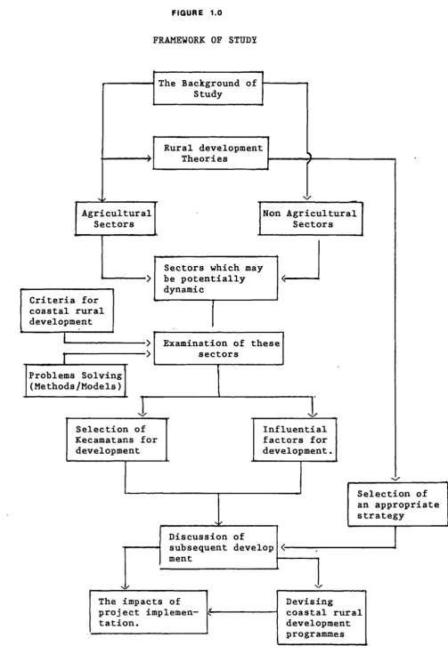
FIGURE 1.0
FRANEWORK OF STUDY
The Background of Study
Rural development Theories
Agricultural
Sectors
' >
Efor coastal rural Idevelopment
_1 >
IProblems soiving
(Methods/Models)J
-Selection of Kecamatans for development
Non Agricultural Sectors
Sectors which may be potentially dynamic
Examination of these sectors
Influential factors for development.
Selection of an appropriate strategy
Discussion of subsequent develop ment
The impacts of Devising
project implemen- coastal rural
tation. development
To achieve this purposes and objectives, certain initial
assum-ption are made:
1.that selected kecamatans are able to effect a successful
level of investment in certain sectors.
2.that successful development of selected kecamatans can be
achieved with the limited development funds available.
3.It is necessary to establish priority of kecamatans for
development in coastal rural area on which the promotion of
selected kecamatans may be based.
4.that coastal rural areas can stem or reverse rural emigration
by creating areas of opportunity within each kecamatan, based
on their individual advantageous elements for development.
5.that guided development of selected kecamatans can accelerate
CHAPTER 1
INTRODUCTION
Countries in Southeast Asia face common problems in developing
coastal rural areas and their associated resources. The
principal problems arise from the twin effects of a rapidly
increasing population and limited natural resources.
Increas-ing population densities lead to acceleratIncreas-ing rates of
exploitation of traditional resources, such as fisheries,
coral. The limitatlons in natural resources relate to both
renewable and non— renewable resources, in the agricultural and
in the nonagricultural sectors of the economy, inevitably
affecting the economic viability of the region as a whole in
the long term. The combination of the above trends results in
a progressive decline in available natural resources,
particularly near population centres. People have to travel
further and expend more energy in order to obtain the same
return and eventually the harvest even of renewable resources
ceases to be economically viable. At the same time, people
living in these areas have legitimate expectations, going
beyond the fulfillment of basic needs.
Population growth alters the socio—economic and physical
character of the region. Attention must therefore be directed
towards solving the inherent problems of inadequate
opportunities, facilities, services, and infrastructure in
these areas. Such changes may be expected in coastal rural
areas in many developing countries, and the problems they cause
are severe enough to require the adoption of a well thought—out
6
and economic opportunities available to the local population.
The government of Indonesia recognizes the importance of
developing coastal rural areas as a potentially dynamic sector
of the national economy. This recognition is reflected in the
Government's objectives for rural development, which include
paying increased attention to remote rural areas: to
develop-ing their economic infrastructure, and to creatdevelop-ing self-reliant
bases for rural development (Third Five Year Development Plan
of Central Java Province 1979/1980-1983/1984, Central Java
Province Government, 1979,Book 3,p27). The second and the
third of these objectives each imply the development of rural
resources, including agriculture, human resources, and the
nonagricultural activities. However, development programmes
intended to achieve these objectives have not been formulated
clearly enough by the various levels of government- central,
state and local- in preparing specific plans. There is
therefore a need for a more detailed analysis of the problems
in order to set out an appropriate development strategy, and to
identify the significant factors affecting the choice of a
development policy.
This study is concerned with analyzing some of the major
problems facing coastal rural areas in northern Central Java.
The discussion will also examine the unsatisfactory elements of
previous policies, namely agricultural development programmes.
It is not intended to underestimate the role of the agriculture
sector in terms of sustaining rural development, however, but
it is also intended to examine the importance of other sectors
involved in the rural development process. It is also
rela-tion to developing coastal rural development strategy for
hand-ling these problems. The main principle on which this whole
analysis was based is an attempt to select significant factors
for the potential development of coastal rural areas. It is
therefore important to define what coastal rural development is
and why it is necessary. The following questions will be
considered :1.what are the environmental problems of coastal
areas?; 2.what are their roles and functions in development?.
These questions are tackled in Chapter I and II of the study.
This chapter gives an introduction to the major objectives of
the study by presenting alternative strategies, which are
discussed in Chapter II. It is also important to understand
the background of the study in both its regional and local
contexts, and Chapter III deals with this. Chapter V attempts
to assess particular potential factors for rural development,
and this examination serves as the basis of Chapter VI. The
link between theory and practice is discussed in Chapter IX in
the context of rural development policy and its effects. It
will be argued that the strategy most likely to be successful
would be to develop a number of selected centres, thus ensuring
efficient implementation of the overall coastal rural
develop-ment programme.
In any event to provide the same level of development for all
villages at once is impossible; but on the other hand, simply
subsidizing each village with a relatively small grant will do
little to encourage the rational development of rural areas.
It is therefore necessary to find a strategy which will
8
accelerate the rate of rural development, ensure the effective
implementation of development programmes, and be appropriate to
the particular conditions in the study areas. Although several
different programmes have been implemented already by the
Indonesia Government, satisfactory results have not yet been
achieved. Specific problems have been encountered with several
programmes in northern Central Java precisely because there was
no overall strategy to guide these activities. The development
plans for rural areas which has been approved by Central
Gover-nment do not take into account the resource potential of each
village especially villages in coastal rural areas, and
therefore cannot ensure coordinated development of the region
as a whole. The rural development programme in Indonesia is in
fact to be a top-down programme, and the bottom-up approach has
been neglected.
Since only some of the centres can be developed because of
restricted funds it is necessary to select those areas which
have the greatest potential for development. In the various
sectors of development a selective strategy may be more
effec-tive as an alternaeffec-tive to general and indiscriminate coastal
rural development.
It is therefore important to develop suitable detailed
strategies for rural development, to identify the dynamic
sec-tors, and to specify the basic principles underlying these
I.l.The Coastal Zone
The coastal zone is made up of a complex web of interrelated
resources, natural and man—made, renewable and non—renewable.
It forms the interface between land and sea, and between marine
salt water and terrestrial fresh water. It is not easy to
place precise boundaries on the zone and definitions abound in
the literature. Individual authors tend to define the area
with reference to the purpose of their study. Ketchum (1972),
for example, considers the combination of demographic,
func-tional, and geographical aspects on his definition:
'The coastal zone is a broad band of dry land (shoreland) and adjacent ocean space ( water and submerged land in which land ecology Wand use directly affect ocean space ecology, and vice versa). Functionally, it is a broad inter —face between land and water where production, consumption and exchange processes occur at high rates of intensity. Ecologically, it is
an area of dynamic biochemical activity but
with a somewhat limited capacity for supporting various types of human use. Marine influence
(salt water) penetrates into estuarine areas to various extents, and the effects of ocean tides may extend even further upstream than salt penetration....
Other authors define it by emphasizing the physical aspects and
-one of the most straightforward of these definitions is given
by the United States Commission on Marine Science, Engineering
and Resources (1969):
The coastal zone is a region of transition
between two environments,the land and the sea
It has been defined as that part of the land
affected by its proximity to the sea and that
part of the ocean affected by its proximity
10
Since the former stresses the socio-economic and environmental
aspects as well as physical aspect, it is more appropriate for
this study. For this reason, the study interprets the coastal
rural area simply as 'a region of transition between two
environments, the land and the sea, where production,
consump-tion and exchange processes occur at high or low rates of
intensity'.
I.2.Rural Areas
The term 'rural' is applied to a wide variety of areas, and can
be defined by a number of criteria (Mason,p25). This variety
leads Clout to conclude that no definition has widespread
applicability (Clout,1972). However, the terms'rural' is most
generally understood as the antithesis of the term 'urban'.
So, everything that is not 'urban' is 'rural'. The term
'urban' is usually characterized by population concentration,
occupying a cluster of built-up areas in a compact space by the
dominance of non-agricultural occupations, and by the existence
of 'incorporated' local government, in varying combinations.
The term 'rural area' might also be defined simply as one in
which agriculture and forestry are the predominant form of
productive economic activity (Whitby, et al, p 7). Thus,
'rural development' pertains to the development of
agricul-tural, mineral, water, fishery and forestry resources for the
prosperity and well-being of the rural population and the
advancement of the rural economy. In a physical context, a
coastal area is an area which is adjacent to the sea, and where
these coastal resources. Economically, fishing is usually an
important predominant form of productive economic activity.
The term 'development' may be seen broadly as an improvement in
the quality of life of the population, including social,
cul-tural and political welfare as well as economic opportunities.
Courtenay (1985,p.2) , argues that development implies
improvements in opportunities for education, participation in
cultural and sporting activities, provision of adequate health
care and a pleasant living environment, freedom from servitude
to other people or institutions, as well as the chance to be
properly fed, clothed and sheltered. Myrdal defined
develop-ment as the upward movedevelop-ment of the whole social system
(Myr-dal,1968). The International Conference of Population (1983)
described the term 'development' as an integrated process of
interrelated economic, social and political changes, the
ultimate aim of which is the constant improvement of the
well-being of the entire population. Easterlin defines
'develop-ment' as a rapid and sustained rise in real output per head and
attendant shifts in the technological, economic and demographic
characteristics of society' (Easterlin, 1968). Mabogunje
categorizes the term 'development' under 4 major headings,
1.Development as economic growth 2.Development as modernisation
3.Development as distributive justice
4.Development as socio-economic transformation
He discusses each of these separately in order to support his
definition (Mabogunje, 1980,pp 35-50). The World Bank
(Harris,1982, p 15) defines rural development as 'a strategy
designed to improve the economic and social lives of a specific
12
rural development by empahisizing socio-economic aspects.
Thus:
Rural development is concerned with the improvement of the living standards of the low-income population living in rural areas on a self sustaining basis, through transforming the socio-spatial structures of their productive activities (Mabogunje, p.94)
Taylor gives a similar definition of rural development
'... a series of qualitative and quantitative changes occurring among a given rural population and whose encouraging effects indicate in time a rise in the standard of living and favourable changes in the way of live'. (Taylor, 1975).
Another author,Kulp, defines rural development as
'the set of economic and social development activities peculiar to the process of transforming the traditional as a whole'(Kulp, 1970,p 14).
All these provide different perspectives and emphases in
development. On the basis of these definitions, however,
coastal rural development may be defined as a strategy designed
to improve or to change the economic and social life of people
living in coastal areas, so as to achieve a rise in the
stan-dard of living through transformation of the socio-spatial
structures of their productive activities.
It is necessary to point out that some authors imply that
social and economic life in rural areas should be changed
through a 'modernisation' process. Einstad points out that
'historically, modernisation is the process of change toward
those types of social, economic, and political systems that
have developed in Western Europe and North America from the
seventeenth century to the nineteenth century and have then
spread' (Einstad, 1966, p 1). Modernisation 1 may be seen as
Mabogunje argues that : 'development is nothing if it is not
the effective diffusion of innovations (Mabogunje,p 114).
Therefore, in this study coastal rural development is seen
primarily as a process of change in which economic advancement
is the basic factor.
I.3.Definition of problem
Specific rural development policies have been in force in
Indonesia since 1950, and hav. focused on the need to provide
sufficient food for the country's large population
(Hard-jono,1983). The prime aim has been agricultural development
and this has affected the overall rural development strategy;
since agricultural development has been the principal policy of
Central Government, it is reflected in the development plans of
the Local Government agencies in the rural areas, which have
concentrated on making each village, self—sufficient in food
supplies. The implementation of this strategy has not yet been
compi eted.
The failure of the 1956-1960 Development Plan to achieve its
targets in the agricultural sector, and the failure of Land
Reform Programme in 1960 (which was inspired by the ideology of
the Communist Party) showed the ineffectiveness of these for
rural development strategies. There was a slow progress of
rural development during the period 1950-1965. After 1965, the
agricultural sector was still given priority, iii order to
achieve self—sufficiency in rice production through intensified
cultivation. Several programmes have since been launched by
Central Government, such as 'Bimas' (Mass Guidance) which is
14
Intensification) which attempts to extend to farmers such
ser-vices as the provision of high—yield seed and guidance by
extension workers and 'Insus' (Special Intensification), which
selects the land for intensification. All these programmes are
manifestations of the fundamental Government strategy of
developing the agricultural sector and to intensifying food
production. They indicate that rural development policy in
Indonesia is as yet not directed towards a broad spectrum of
development because it is still concentrated on the
encouragement of plantation crops and is of more benefit to the
villages which have an orientation towards large—scale rice
cultivation rather than coastal villages with a different
resource base. The implementation of rural development
programmes also seems to neglect other resources which can be
identified as having potential for development, and in
particular some nonagricultural aspects. Though rural
develop-ment in Indonesia is often identifiable with agricultural
development, it also acknowledges that social and cultural
fac-tors have a significant influence in determining development,
but the results of the implementation of such programme do not
satisfy rural people as a whole. Taylor argues that rural
development is a much wider concept than simply agricultural
development, although the agricultural production base must
usually be a vital component of any rural development programme
(Taylor, 1975). In essence, both natural and human resources
must be recognized as the basic to any rural development. Both
involve a number of variable elements. Some of these are
related to the heterogeneous nature of coastal rural regions,
significant to development in these areas. The heterogeneity
of coastal rural regions is reflected in the natural resource
base, in available facilities, and the potential interest in
the human resource. Unfortunately, they are rarely perceived
the significant elements for development either by Central or
by Local Government.
In most developing countries, like Indonesia, capital is
scarce, and any capital needed for coastal rural development
must compete with other demands for financial support. The
policy for rural development is also different from country to
country. In Indonesia, the Government has provided rural areas
with development subsidy and certain rural development
program-mes such as Family Planning Programme and Family Welfare
Educa-tion (PKK) . However this subsidy does not correspond to the
demands for financial support in all rural areas. It is true
that around 80 per cent of the Indonesian people are living in
rural areas, but Government policy for allocating development
subsidies to villages is deficient compared with the subsidies
available to regencies or to provinces. In 1984, for example,
the total development subsidy for 67534 villages was only 0.9
per cent of total actual Government development expenditure
(Table 1.1), and 17 per cent of the total development subsidy
of the administrative areas.
Table 1.1
Actual Government Development Expenditure of Indonesia (x Rp 1000,000,000)
Type of expenditure 79/80 80/81 81/82 82/83 83/84
1. Department-Institutions 1480.3 2533.3 2724.6 3260.9 3219.6 2. Development subsidy to
16
3. Development subsidy to
regencies 87.1 119.4 162.7 193.9 194.1
4. Development subsidy to
provinces 100.7 166.7 215.0 253.0 253.0
5. Investment through the
banking system 252.8 476.5 480.9 336.6 591.7
6. Fertilizer subsidy 125.0 283.6 371.4 420.2 324.2
7. Construction of primary
school 155.8 249.8 374.5 267.4 549.3
8. Regional Development
Contribution 71.4 87.2 94.5 105.2 132.4
9. Sanitary Facilities!
Public Health Centre 30.0 50.4 78.8 80.3 87.3
10.Construction and
rehabilitation of market 12.4 2.5 6.0 4.5 10.6
11.Replanting and
Afforestation 40.8 48.6 70.4 49.4 59.4
12.Timor Timur Province 6.6 6.4 6.8 5.8 5.2
13.Road Facilities 13.0 25.9 54.8 42.4 64.6
14.Others 291.0 385.5 565.3 326.7 448.7
15.Projects aids 1316.3 1429.7 1663.9 1924.9 3867.5
1 o t a 1 4014.2 5916.1 6940.1 7359.6 9899.2
[image:36.595.71.549.66.381.2]Source : Statistical Year Book Central Bureau of Statistic of Inclonesi a
Table 1, shows that regional areas are still the focus for
development by Central Government. First priority was given to
development at the province level; the second, to the regency
level; and last to the rural areas. To implement rural
development programmes, the Government has decided to subsidize
each village with only Rp.1,000,000 per year (i.e. a total of
$1575 in 1981). This policy was carried out as a response to a
desire for the equitable distribution of development subsidies.
However, this subsidy was not enough to finance significant
development in rural areas, and with such a limited subsidy,
development in all sectors in rural areas is difficult to
achieve.
Another dimension of these problems is regional planning by
Central Government. Regional planning is at present expressed
Java Province. In this plan there is, however, as yet no
explicit programme of coastal rural development and coastal
rural development has been very slow because there is no
guidance provided for it. An appropriate strategy is needed
for this purpose. The development of both the natural and the
human resources is an important issue for the development of
these heterogeneous areas. It is the purpose of -this thesis to
identify the various elements in development, and to select the
most significant factors. Thus, in order to suggest how
coastal rural areas might be developed, several strategies for
rural development will be discussed, an appropriate strategy
will be formulated , and its application to the development of
coastal rural areas will be examined.
I .4.Database
Such a study of coastal rural development in northern Central
Java thus requires the collection of a variety of data sets
concerning the coastal rural environment, including the
facilities and activities in these areas, current development
policies, and also the role of the particular study areas in a
regional context.
The information required may be categorized thus :
1 .Economi C;
2. Social; 3.Physical; 4.Demographic; 5.Environmental.
Such a varied data base requires the use of several sources,
and different techniques need to be used. Integral to the
collec-18
ted at district level, both general information concerning the
study areas and specific information for more detailed
exami nation.
The general information relates to population, rural facilities
and rural transportation , and is taken from published
materials. Specific information, local area problems or
farmers incomes, for example, has been obtained by a
question-naire survey of Regional Planning and Development Office of
Central Java Province.
With regard to the kecamatans selected for study, information
was collected from the following sources
1.Documents published by Central or Local Government, such as
report, books, maps and plans.
2.Information and results surveys of local Government or
institution.
Published documents includes maps, reports and statistical year
books. Other published materials have been examined such as :
1.The Third Five—Year Development Plan of Central Java Province
1979/80 —1983/84
2.Central Java Statistical Year Book 1984.
3.Statistical Year Books of 9 Regencies : Pati, Rembang,
Demak, Jepara, Kendal, Pekalongan, Batang, Brebes and
Pemalang (database:1984).
Other information was obtained from Government offices, in
Provincial Planning Offices, the Directorate of Geology and
other Government institutions. This information is relevant to
the activities of these Ministries or to Local Government in
the study area.
I.5.Field Survey
Field survey is a means of investigating special problems
relevant to the aims of the present study. Questionnaire
sur-vey are usually executed to establish the nature of the
problems experienced by rural people in the villages such as
their day—to—day activities, and their economic circumstances.
The field surveys were a means of investigating special
problems relevant to the aims of the present study. Sampling
techniques are usually used by some researchers in the study
areas where hundreds or thousands of respondents might be
interviewed. Ideally, the sample size should be at least five
percent of the total population (Leven,1982). However, a
questionnaire survey may not always be necessary provided that
1.some information relevant to the objectives of the study is
available in Local Government offices;
2.surveys with the same object have been executed by other
researchers or institutions, so that their results may be
utilized by others.
This study considers the important of questionnaire, but
because of time and resource constraint, a traditional sample
20
Groups of people of stature within the village were
inter-viewed. The survey of all sub-districts in the study areas,
however, were undertaken by Public Works Ministry and
Provincial Planning and Development Office. The author
believed that this added to the reliability of the data.
The present study thus utilizes field survey data obtained by
both Provincial Planning and Development Offices and also field
survey data from the Public Works Ministry. Questionnaires in
the Public Works Ministry attempt to establish the social and
economic aspects of life in rural areas, and the local problems
experienced by coastal people. These results are of use in the
present study, in that almost all the data provided can be
utilized for analysis and assessment relevant to its aims.
Without a substantial budget it is not easy for an individual
researcher to plan and implement such a survey in a large
region of variable accessibility, so that information from the
work of others is essential to the achieving of the objectives
of present study.
I.6.The 'kecamatan' (sub-district) in development programmes
Development programme regions may be viewed at 3 different
scales, regional, urban, and rural regions. This categorization
is essential if effective policy decisions are to be made as
part of a development plan. A programme region is an area for
which particular decisions are made on an economic, a social or
a physical basis. Since the implementation of a rural
develop-ment policy requires the power to act, and this power rests
more with Government than with private agencies, such regions
jurisdiction at a defined level. In this study,the 'kecamatan'
has been acceptedas the representative unit in coastal rural
areas because it is a sub—district administrative area and also
constitutes the smallest unit of the organizational structure
of Government in Indonesia. Furthermore, the study of rural
development requires comparative statistical data and these are
normally collected on a kecamatan basis. Thus it is
unavoidable that existing programming units are used as a basis
for study. The optimal planning unit will also vary according
to the problem under investigation. For example, a question
such as the selection of coastal villages for selective
development in an area containing several villages with
different potential for development must be dealt with at the
sub—district level, whereas other questions affecting a wide
area can be handled only on a regional basis. The kecamatans
chosen for this study are :
Regency : Rembang B em a k Pekal ongan
1.Tirto
2.Wi radesa
3.Sragi Kecaniatan : 1.Sarang
2.Kragan
3.Sluke
4.Lasem
5.Rembang
6.Kaliori
1.Wedung
2.Bonang
3. Karangtengah
4.Sayung
Regency : Pati Kendal Pemal ang
E
0 0 0
I-Z+:
01
4 > 4 -,
-J 4 I.
-,-
z • Ui - C.) • U_
•! z
t0 I.. 4 0 0 -J
j 7 C?
22
4
lU
4
U)
z 4 I-z
4
•\ \ :
.1 •.
;• I, $ '— _.
% c'' ,' -\ I %_\
;c, Pyii
_-.j
t-- I—' -- --
I _f'I
- • -1
2
>
r)
U
—4 <
I-LU
0
I
24
2 .Juwana
3 .Wedari jaksa
4.Margoyoso
5.Tayu
6.Dukuhseti
2. Brang song
3.Kendal
4. Pat ebon
5.Cepiring
6.Kendal
2. Petarukan
3.Taman
4.Pemalang
Regency : Jepara Batang Brebes
1.Kel ing
2.Bangsri
3.Mlonggo
4. Je par a
5.Kedung
1.Gringsing
2.Limpung
3.Subah
4.Tulis
5 .Batang
1.Brebes
2.Wanasari
3. Bul akamba
4.Tanjung
5. Losari
(See figure 1.3)
Before proceeding further, it is important to define the
func-tion of the kecamatan within the overall Government system.
I.7.Organizational Structure: The Government Systems in
Indonesia
The Government organization in Indonesia is based on the
centralisation principle as laid down in the Constitution of
1945, this provides for the direct control of every aspect of
development in the provinces to be recognised and validated by
Central Government. The strength of the Central Government is
expressed in the system for the implementation of programmes,
by a hierarchy of officials through to the sub-district level
develop-+
0
I 4
(I)
4 S
0 • .5
- -4
l•
p-Ii,
_4 S
UI U)
1
2
-4
1h
-I-4-44--id E43U)
•
fi
• rr)l
Jflj
4)Q..l..4.4IlN U)
• ._x
id •:
L . ?
•
ii
ru -O'O-1N I
-4-4-4..'
-.5 Cs
.5
.5
Ii .
-.2
2
26
ment plan is undertaken and controlled by the Ministry of Home
Affairs through the Governor of the Provi nce. The governors,
in turn, delegate this responsibility to 'bupatis' (regents),
then ,to the 'camats' or sub—district heads, who are
responsible to the bupatis. Thus, a kecamatan, controlled by a
'camat', is the smallest unit in the organizational structure
of the system. The camat, however, is in charge of several
desas (villages) which are headed by 'lurahs' or village—
headmen, and in performing his role an individual camat will be
assisted by the 'lurahs' under his jurisdiction.. Table 1.2
Table 1.2
Organizational Structure of System of Government in Indonesia, in Relation to Rural Development
! Ministry of Home Affair
! Directorate of Rural
I Development
'I,
Province-Head
Governor I
1
Regency-Head I
Regent !
.1
Kecamatan-Head 1
I Camat I
I Village-Head
I
lurah I
I.8.Structure of the Study
The study is divided into three sections. The first section
(Chapter I-IV) is an Introduction and Literature Review. These
chapters consider the background of the study of northern
coastal rural Central Java, and examine particular theoretical
concepts relating to development strategies. These chapters
also provide background information concerning the physical,
social, economic and environmental features of the area of
28
The second section (Chapter V,VI, VII, and IX) examines some of
the factors affecting development and the priority of
kecamatans and also the proposed programmes for individual
groups of kecamatans for development, implementation of
development programmes in a kecamatan selected.
The third section (chapter X and XI) discusses the
implementa-tion of development programmes in a kecamatan selected, and
likely the impact of development to the social, economic and
environmental aspects.
The 'Content of the Study' section sets out the objectives,
techniques, data and procedure and assumption of the study on
which it is based.
Chapter I contains some definitions and formulations and a data
base.
Chapter II is a review of literature relating to rural
develop-ment strategies These concepts have been taken from Western
theories, and the objectives, the targets and the description
of the development process are discussed. It also discusses
the current regional and rural development strategy in Central
Java.
Chapter III discusses the Government Policies at national and
local scales in relation to rural development.
Chapter IV provides background information about the study
area, a geographical description of the region and a summary of
its basic social and economic conditions.
programme implementation examines some factors in development
and justifies the selection of particular kecamatans, in
rela-tion to •the criteria used and the method of applying them in
the selection process.
Chapter VIII sets up the priority of kecamatans for development
based on the potential factors analysis and the proposed
programmes of individual groups of kecamatans.
Chapter IX discusses the implementation programme in the
kecamatans selected.
Chapter X attempts to apply the alternative concept for
selec-ted kecamatan development.
Chapter XI discusses the effects of this policy on the
environment, and also consider the problems which might be
experienced in the kecamatans not selected.
Chapter XII sets out several conclusion from the study as
IIA\IPIII IDI
CHAPTER II
RURAL DEVELOPMENT STRATEGIES : THEORETICAL FRAMEWORK.
Indonesia, like other Third World Countries, is faced with many
problems in choosing suitable rural development strategies.
Many theories have been posited by Western scholars as the
basis for developing a strategy for rural or regional
develop-ment. Several countries, for example India, Iran, Korea and
Malaysia have attempted to apply Western development concepts.
( Lo,Fu Chen & Salih,Kamal,1976) India applied the Growth Pole
concept in devising its rural growth center programme.
Malaysia adopted it in order to develop its industrial sector,
whereas Korea applied Growth Pole theory in devising its
industrial city development policy for the southern coast of
Korea, in the context of a decentralisation plan. Iran adopted
it as the basis of its industrial policy (ibid). Of course,
there is justification for the application of Western concepts
in attempting to tackle the problems of rural, regional, and in
some cases, national development. The concepts must, however,
be understood and evaluated accurately before they are adopted
as a strategy for development in any developing country.
Ron-dinelli and Ruddle (1978) consider that theories and principles
of spatial planning are in many cases elusive, abstract, and
inconclusive. They further conclude that, as in other fields
of development administration, many prescriptions for spatial
planning have been derived from the experience 'of Western
industrialized countries. Some prescriptions are simply not
transferable and others have to be carefully adapted to unique
local needs and constraints.(Rondinelli,Ruddle,1978, p.14) It
31
concepts ,it is necessary to clearly identify key factors in
local situation. A discussion of these development strategies,
including the Growth Pole, Spatial Integration, Small City
Development and Agropolitan Development concepts, is clearly
necessary. The aim of this discussion is to analyze and
com-pare these different strategies in order to select one
appropriate to coastal rural development.
II.l.The Growth Pole Strategy
The Growth Pole concept was originated by the French economist,
Perroux, whose work focused on the development of 'growth
poles' in economic space. This theory offers an ideal solution
to the planning problems encountered in remote and pressured
rural areas (Cloke,1979,p.28) The Growth Pole approach
identifies two opposing forces governing the movement of
economic prosperity, namely
1.the 'backwash effect' (Myrdal, 1957,p.28) or the
'polariza-tion effect' (Hirschmann,1958,p.p 100-117). This is the
ten-dency of central nodes to attract factors of production such
as entrepreneurial skills, labour, raw materials and
invest-ment from their surrounding areas; and
2.the 'spread effect' (Myrdal,1957) or 'trickling down effect'
(Hirschmann, 1957).These are forces causing the spread of
development and prosperity from a centre to its' periphery.
The Growth Pole concept is based on the belief that growth
does not appear everywhere at the same time; it occurs at
points or poles of growth, with variable terminal effects on
Perroux defines 'Growth Poles' only and specifically in
rela-tion to abstract economic space and not in relarela-tion to
geographic space, which he dismisses in 1950 as 'banal'
(Dar-went,D.F.1975,p.540) Boudeville, another writer on the Growth
Pole theory, extended Perroux's original work to take account
of the geographical dimension ,identifying what he termed
'Growth Centres'. The 'Growth Centre' is a somewhat wider
concept than the 'Growth Pole', and is not closely related to
Perroux's initial 'Growth Pole' notion (Darwent, p 548). Thus
Glasson suggests, to keep the distinctions clear and in
per-spective, the term 'Growth Pole' should be used to refer to the
original concept of Perroux without any specific geographical
dimension, while the term Growth Centre or growth point should
refer to a spatial location (Glasson, 1974,p.146). The Growth
Pole and Growth Centre theories are the most frequently used
bases for planning the concentration of investment in selected
areas. The key elements of Perroux's ideas are : the leading
industry concept, the polarisation concept and the spread
effect concept. Glasson explains these concepts as follows.
The concept of leading industries and propulsive firms
recognises that at the centre of each Growth Pole is a large
company belonging to a leading industry, which dominates other
economic units. Rapid growth of the leading industry induces
the polarisation of other economic units into the pole of
growth. Implicit in this process of polarisation are the
various agglomeration economies (internal and external
economies of scale). The concept of spread effects recognise
that in time the dynamic propulsive qualities of the growth
(Glas-33
son,1979, p 147). In fact,this trickling—down or spread effect
is a useful analogue model with which to view coastal rural
development. The effect has an ability to stimulate rural
activities in some sectors, by creating opportunities for
employment, and stemming urbanization in rural areas. On this
basis Growth Pole Theory appears to justify the concentration
of development at certain points in coastal rural areas, so
taking advantage of these trickling—down effects. However, the
Growth Pole Model has evolved through investigation at regional
and national levels, and the operational valued the model in a
microcosm is very much dependent on the diluting effects of
scale (Cloke, 1979.p.28). The relative importance of the
spatial dimension has also been sustained by Kuklinski and
Taylor (1972). Kuklinski claims that Growth Poles are of
national significance, in as much as their development affects
not only the structure of the regions in which they are located
but also inter—regional correlations, and therefore the country
as a whole, thus Growth Centres are basically intra—regional in
character (Kuklinski,Antoni (ed)., 1972,p.126). These
differences in functions are closely related to differences of
scale. Taylor also identifies the importance of differences of
scale and argues that growth centres can be divided according
to scale into national ,regional and local centres
(Taylor,1975,p.308). Thus, the Growth Centre concept can be
seen to have detached itself, at least in part, from the theory
which gave its birth, and this has led to Growth Centres being
defined in different ways with the various definitions placing
more or less emphasis on the question of scale (Cloke,1979).
local scale is of critical importance and that developmental
efforts should be concentrated first at the local level (
Cloke,1979 in Taylor,1975 p.309)
Some authors in defining Growth Centres give emphasis to
different components of the concept. Allen and Hermansen
emphasize service provision :
'...a centre at a regional level in addition to its main function as a regional service centre, also provides a prosperous and reasonably diversified industrial structure The centre should be growing or show poten-tials for growth of economic activity,employ ment, population and income. Such a centre
should be above certain population levels , or if it is to enjoy self sustaining growth be planned for such a level.
(Hermansen, T.,1969)
Nichols emphasises self-sustaining growth:
'..an urban centre of economic activity which can achieve self- sustaining growth to the point that growth is diffused outwards into the pole region and eventually beyond into less developed regions of the nations.
(Nichol s,V. ,1969.)
Hansen provides a useful working definition by considering
com-munities or places and their activities :
'By a growth centre or centres is meant a complex consisting of one or more communities or places which, taken together, provide or are likely to provide, a range of cultural, social, employment trade and service functions for itself and its associated rural hinterland.
( Hansen , 1972, p. 169)
Hansen's definition may be suitable for use in defining a
growth centre or centres in coastal rural areas, since the
con-ditions mentioned above are reflected in these areas. It
offers a tool for development policy which is suitable in
object, form and composition as well as in goals and objectives