LAN D SCA PE
R E V I E W
A S O U T H E R N H E M I S P H E R E J O U R N A L O F
L A N D S C A P E A R C H I T E C T U R E
T H E M E
Mappings
CONTRIBUTORS
Hannah Lewi, Andrew Saniga, Wally Smith, Immersive and Temporal
Experiences in Historic Landscapes: Designing a Mobile Digital Guide for
the Royal Botanic Gardens Melbourne
Brent Greene and Heike Rahmann, Glitterosophy: The Good, the Bad
and the Ugly
Fiona Johnson and Jillian Walliss, Reconciling History: Inserting an
Indigenous Space into the University of Melbourne Campus
Alison Loveridge, Rebecca Duell, Julie Abbari and Michelle Moffat,
Night Landscapes: A Challenge to World Heritage Protocols
Ian Henderson, Lan Yuan: A Garden of Distant Longing: Book Review
Shannon Davis, Go With Me: 50 Steps to Landscape Thinking: Book Review
Jacky Bowring, Making Landscape Architecture in Australia: Book Review
V O L U M E 1 5 ( 1 )
ISSN 2253–1440 Published August 2014
© Edition: School of Landscape Architecture, Lincoln University. © Text and illustrations: individual contributors, unless otherwise noted.
1
L a n d s c a p e r e v i e w 1 5 ( 1 ) p a g e s 1 – 3
Jacky Bowring is Professor of Landscape Architecture and Head of School, School of Landscape Architecture, Faculty of Environment, Society and Design, PO Box 85084, Lincoln University, Christchurch 7647, Aotearoa New Zealand.
Telephone: +64–3–423–0466 Email: [email protected]
Key words Mapping Composite maps Heritage interpretation Counter-mapping History and design
Mappings
jacky bowring
editoriaL
M
aps are potent analytic and generative tools. while often assumed to beobjective, maps are inherently subjective. the choice of what and how to map is core to a map’s meaning. the mapping process, therefore, embodies power and knowledge and can be harnessed in the imagining of new understandings and new visions. the thread of mapping can be traced through the four papers in this issue of Landscape Review. each paper engages explicitly or implicitly in mapping and enlists maps across a spectrum, from description to subversion.
First, Hannah Lewi, andrew saniga and wally smith present a contemporary version of a map: an ipad app. in their paper, ‘immersive and temporal experiences in Historic Landscapes: designing a Mobile digital guide for the royal Botanic gardens Melbourne’, the authors discuss how Master of Landscape architecture students at the University of Melbourne used this modern mapping approach to interpret the historical landscape of the Botanic gardens. the approach draws on a centuries-old legacy of guiding visitors through designed landscapes using some kind of interpretive tool. in the past, it would have been a guide book or literally a map. But devices were also available that helped amplify and shape a viewer’s perception of the place they were exploring.
in imagining the ipad app developed by Lewi, saniga and smith, another device comes to mind. in an uncanny echo of the ipad, many eighteenth-century
tourists would have travelled holding a flat device about the size of a large
envelope with a shiny black surface. For the eighteenth-century tourist, however, this was about being connected not to the internet and the virtual world of an app but to the highly polished convex black-glass surface that distorted the view so it appeared more like a painting by claude Lorrain. Lorrain was a painter whose work provided a template for the composition of ‘picturesque landscapes’ and, in recognition of this, the curved glass mirror was known as the claude glass. in both cases – the ipad and the claude glass – the hand-held device is interactive, providing both a shared experience in terms of common conventions and one that the individual controls through their own itinerary. this dual use highlights how the process of interpretation negotiates both the collective and the individual relationship with the landscape.
2
j a c k y b o w r i n g
Brent greene and Heike rahmann explicitly use mapping in their paper,
‘Glitterosophy: The Good, the Bad and the Ugly’. In reflecting contemporary
trends towards mapping as a generative design tool, greene and rahmann draw in particular on the composite mapping approach – of mapping several variables at once. they explain that composite maps allow for multiple time periods to be shown and, through this, to reveal latent patterns. this revelation leads towards the generation of the physical form that draws on these historical layers, and engages with the processes that have shaped the landscape. For greene and rahmann it is the place of weeds that is of particular interest, and they explain
how species classified as weeds have important attributes that can help with the
rehabilitation of toxic soils. their design process outlines the possibilities for
enlisting and enabling these species to infiltrate sites and create positive benefits.
this elevation of the other, of that often excluded, presents a further form of mapping as it echoes with the concept of counter-mapping – an approach that
maps against the grain of dominant power differentials. Counter-mapping – the
term was coined by peluso in her work in the forests of indonesia (peluso, 1995) – is a type of critical cartography, where the process of mapping is in itself a form of critique. this perspective presents a potentially useful tool for landscape architects working against the grain, in the way that greene and rahmann are
with their ‘Glitterosophy’ project. Many of the counter-maps produced reflect a
‘grass-roots’ philosophy, where those who otherwise lack a position of power are able to make a point through mapping.
the idea of counter-mapping, or subversion of traditional mapping conventions, also underpins the paper by Fiona Johnson and Jillian walliss, ‘reconciling History: inserting an indigenous space into the University of Melbourne campus’. again working with Master of Landscape architecture students at the university, Johnson and walliss explore how mapping can reveal aspects of suppressed history, in this case of the landscape of the University of Melbourne. through the process of mapping aspects of the campus that had been overlooked or edited out of the understanding of the campus history, students generated ideas for a space that could do more than simply represent aspects of history. the challenge was to create a space that could support reconciliation. through the design process, however, it became clear it could not be achieved by
landscape architecture alone. As well as reflecting on the complexity of creating
such a place, the paper reports on a very tangible outcome. the mappings produced as part of the studio project became the basis for a new guided walking tour of the campus, one that reveals previously invisible landscape elements.
as a form of description, maps can provide the necessary coordinates for understanding the spatial nature of a phenomenon and, subsequently, supporting its protection through legislation. the fourth paper, by alison Loveridge, rebecca
Duell, Julie Abbari and Michelle Moffat, examines the Aoraki Mackenzie Dark Sky Reserve in the South Island’s Mackenzie Basin, and the possible consequences of
3
j a c k y b o w r i n g
in this context, mapping provides vital spatial information about the coalescing uses in the area and the ways in which growth and development can be carefully controlled to avoid destroying the night-sky darkness through light pollution.
the three book reviews in issue 15(1) could also be seen as maps of sorts.
Two of the books reviewed have specific geographic locations, and the other is
more of a guide for a designer’s journey. ian Henderson reviews James Beattie and duncan campbell’s Lan Yuan: A Garden of Distant Longing, which explores the chinese garden in dunedin within a broader cultural context of the chinese in new Zealand. Henderson draws attention to how this book is part of a wider discourse of particularity within landscape architecture, with this point of
departure providing a reflection on the place of imported gardens in New Zealand.
in the second review, shannon davis critiques Go With Me: 50 Steps to Landscape Thinking by thomas oles with Marieke timmermans and Jacques abelman. davis frames her review around the idea of a book of tools and how it can be used as a way of seeing things anew. as oles himself advises, it is a book
to be taken everywhere from half-frozen lakes to canals and deserts; it is perhaps
another kind of mapping device, one that is about both orientation and invention.
And, finally, I review Andrew Saniga’s Making Landscape Architecture in Australia. saniga has produced what is destined to become an important work on the history of the landscape architecture profession in australia and beyond.
The sense of geographic particularity is also significant in this book, which traces relationships between people and their environment within the specific frame of
an emerging profession.
while the theme of mapping interweaves throughout the issue, at the same time it embraces another form of representation, the snapshot. this is a word borrowed from thomas oles’s book, as quoted in the review by shannon davis, where oles is seeking to capture the very nature of ‘landscape’ itself. the idea of landscape as a snapshot of cultural and natural processes resonates in the papers and books reviewed, each of which provides a perspective, a way of seeing and
an outlook. We are offered snapshots of many landscapes, with views into the
royal Botanic gardens Melbourne, into a river edge in Melbourne and a creek
margin in Canberra, the University of Melbourne campus, the Mackenzie Basin’s
dark-sky reserve in the south island, a chinese garden in dunedin and the entire continent of australia.
while embracing the southern hemisphere focus promoted by Landscape Review, these views also reverberate much further afield. The richness of
observation and experimentation in this issue demonstrates the potential of landscape architecture as a profession and a discipline to continue to enhance our understanding and experience of the landscape.
this issue of the journal has been some time in the making, and it represents another important contribution to the growing body of research that Landscape Review has established. the next few issues of the journal are already in formation, with several special themes being explored. we are always interested in receiving submissions for the journal, including proposals for themed issues.
reFerence
4 L a n d s c a p e r e v i e w 1 5 ( 1 ) p a g e s 4 – 2 3
Corresponding author:
Andrew Saniga is Senior Lecturer Landscape Architecture, Planning and Urbanism, Faculty of Architecture Building and Planning,
The University of Melbourne, Victoria 3010, Australia. Telephone: +61–3–8344–7056 Email: [email protected]
Key words
History Interpretation Digital technology Education
immersive and Temporal experiences
in Historic Landscapes: designing a
Mobile digital guide for the royal
Botanic gardens Melbourne
hannah lewi, andrew saniga, wally smith
university of melbourne
reflection To orientate is to hop back and forth between landscape and time, geography and
emotion, knowledge and behaviour (Hall, 2004, p 15).
T
his paper explores what mobile digital technology can bring to guiding ourexperience and appreciation of historic, designed landscapes. It focuses
on the authors’ attempt to design and implement a digital ipad tour to help
landscape architecture students with fieldwork visits to the Royal Botanic Gardens Melbourne (RBGM). We situated this digital design project within a set of larger concerns surrounding landscape interpretation, exploration and history. The aim
of this account is not so much to evaluate the success or otherwise of the mobile
guide, or digital technologies generally,1 but to consider how the project has
reproduced or extended long-standing practices of landscape interpretation and
guiding. The importance of conjuring a speculative approach to the perception of landscape, of delving more deeply into the vernacular and historic environments that surround us, is something that JB Jackson emphasised as ‘learning how to see’ and uncovering the ‘nature’ of landscape (1984, pp x, xi).
The pursuit of informed touring around designed gardens – sometimes
supplemented by maps and images – has a long and continuous history. This
includes formative precedents from the eighteenth century onwards in europe
and was further fuelled by the rise of mass tourism in the twentieth century, when visiting gardens became a popular pastime. However, the inculcation of
both an informed understanding of a garden designer’s intentions over time,
and an appreciation of a garden’s sensory experience in the present, has always been notoriously challenging. Edward Casey, for example, asks why the West
was delayed (in comparison with the east) in developing visual languages for
describing and representing gardens and landscapes as a primary subject rather than a secondary backdrop (2002, p 18). In answering, he points to the perceived difficulties of spatially and visually encapsulating any garden or landscape in terms of broad qualities such as scale, viewpoint and movement. Historic responses to this representational challenge gave rise to experimental panoramic, cartographic
and topographical images as potential ways of communicating expansive and
layered landscapes (Casey, 2002, pp 7–14).
5 h a n n a h l e w i , a n d r e w s a n i g a , w a l l y s m i t h
and ever-more reliable connectivity in outdoor settings. For example, in the United States, the Indianapolis Museum of Art has produced a mobile app for visiting the Virginia B Fairbanks Art and Nature Park: 100 Acres, which gives visitors access to videos, photographs and text for locations in the park.2 in another case, the New York Botanic Gardens has created an app that guides visitors through the recreation of Monet’s garden at Giverny. Here, the gardens can be seen through an ‘Impressionist lens’, and visitors use an iPhone camera to create and share images, while another immersive feature allows paintings and plants to be matched.3 Also in New York, numerous apps are available for self-guided tours of Central Park. These use a more passive curatorial formula involving an image of a ‘stop’ representing some form of curiosity in the park, along with associated historic text or narration.
In a different way, the audio-visual modes revealed in the work of Janet Cardiff and George Bures Miller and their numerous scripted ‘Walks’ seek to combine audio, video and narration, reputedly with great potency and with an ensuing ‘psychological immersion’.4 From our research, however, it seems less common to find the presentation of, or interaction with, topographic, cartographic or archival
(visual) information that might allow for a richer combination of cognitive
processes leading to different forms of immersive landscape experience.
Rather than ‘threatening’ our first-hand experience of gardened places, new digital mobile media, if designed with sensitivity and intelligence, can enhance
the exploration of landscaped sites and provide new modes of engagement rather
than merely simulating or reproducing them. These exciting possibilities for
creating new kinds of touring experiences in landscapes motivated the design of
the iPad guide ‘Landscapes in Time: A walking tour of the Royal Botanic Gardens
Melbourne and the domain’ for use by Master of Landscape architecture
students at the University of Melbourne (Figure 1). In this paper we outline the
6 h a n n a h l e w i , a n d r e w s a n i g a , w a l l y s m i t h
particular challenges in making this guide and situate it within the tradition of
touring and appreciating historically significant landscapes and gardens through in situ experience.
The students involved in the guide’s development were undertaking their
Masters of Landscape Architecture at the University of Melbourne, and the field visit was an important component of a course-work subject called ‘History of Landscape Architecture’. The subject provided a critical examination of the
historical development of landscape architectural design and theory including the
events, social influences and personalities involved. The field visit also pursued these broad aims and was supported by the iPad guide, which was designed and updated between 2011 and 2013 along with an accompanying paper-based workbook to be completed and submitted for assessment.
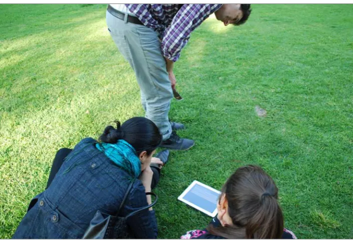
In a pilot study in 2011, 16 students used the mobile guide over a designated two- to three-hour visit in which they were divided into four groups, each having a single iPad to share. They were followed by researchers who observed the usability of the guide. In 2012 and 2013, following improvements to content and navigation, a further 30 students completed the tour but conducted it in their own time. About 10 of these students carried it out alone and the rest worked in groups of two to four people, with the total time spent ranging from three to seven hours. In 2012, the students visited without staff present, but in 2013 two researchers observed them for a limited time. All visits were followed up with a questionnaire and focus-group discussion with students to examine their experience of the field visit and iPad guide. These observations inform the account given in this paper.
As educators, our motivation was to create a functional hand-held digital guide to support the fieldwork of students studying a historical landscape. First,
we wanted to test how the delivery of digital content could extend the ways of
physically guiding students through a site of complex historical significance – whether as a replacement for, or supplement to, a conventional teacher guide. Important to this guidance were the concepts described as ‘directed looking’ and ‘choreographed walking’. Second, we posed the question of how the hand-held
guide might provide resources that informed and augmented a person’s on-site
experience. This is a larger educational issue being pursued by inquiries into ‘mobile-learning’ more generally (Cochrane, 2010; Kinash et al, 2012; Vavoula et al, 2010). Documentary resources particular to the discipline of landscape history and heritage include historical and contemporary maps, archival and contemporary photographs, archival film footage and sound and text narration. A third question, which falls outside the scope of this paper, was how this mode of guided touring might encourage, or discourage, social interaction between students, which is widely understood to foster group learning (Pfeiffer, 2009; Sharples et al, 2005).5 In terms of technological issues, we specifically wanted to explore the possibilities of the iPad format, in contrast to the smaller smart phone,6
as the increased dimensions of a tablet screen supported better map and image
presentation and comprehension, which was clearly important for landscape settings. Other technical possibilities, including the use of global positioning system (GPS) locational information, were incorporated in the design.
7
h a n n a h l e w i , a n d r e w s a n i g a , w a l l y s m i t h
to the historical concerns in this paper, and applicable to all sites of historical design significance, it focused on exploring ways of capturing and experiencing
the changing layers of design intentions and interventions that have shaped
(and sometimes failed to shape) landscapes and gardens. Such design intentions and influences may or may not be extant in the physical fabric of the setting today. An attempt to understand and appreciate these partly visible, partly invisible design intentions involved two possibly contradictory activities. The first was promoting an immersive bodily and sensory experience of the site in a manner sympathetic to its design, and the second was adding to that experience with information and documentation not normally on-hand to the visitor. This
twin agenda – of immersive experience and information – has been analysed
by others through ‘reception theory’ formulated around landscape appreciation (Conan, 2003a, pp 28–31).
in setting the challenge to combine information delivery through the ipad
platform with the promotion of physical and sensory immersion in the site, we were conscious of what Corner has referred to as ‘eidetic operations’ (1999). These ‘operations’ concern the mental imaging of landscape inclusive of not only the visual but also other senses such as the acoustic and tactile. Corner concluded that: ‘the future of landscape as a culturally significant practice is dependent on
the capacity of its inventors to image the world in new ways and to body forth
those images in richly phenomenal and efficacious terms’ (1999, p 167).
Historical design intentions at the royal Botanic
gardens Melbourne
Guided by the contextual focus of fieldwork in the Master of Landscape Architecture subject, our spatial and historical focus was the RBGM and neighbouring sites that form part of the King’s Domain: Alexandra Avenue, Queen Victoria Gardens, the Alexandra Gardens and the Yarra River. The information we chose to present through the mobile guide focused on the intentions and influence of the early gardens’ directors Ferdinand von Mueller (1825–1896) and William Guilfoyle (1840–1912). It was their contribution to design and management that proved so influential to the structure of the contemporary landscape. The inclusion of
part of the King’s domain was as much about being historically accurate in terms of narrating the gardens’ creation as it was about designing a walking route that
negotiated different types of boundaries, including property, visual, physical and the cognitive or even experiential boundaries, we identified as being potentially significant for those experiencing the gardens (Downs & Stea, 1977).7
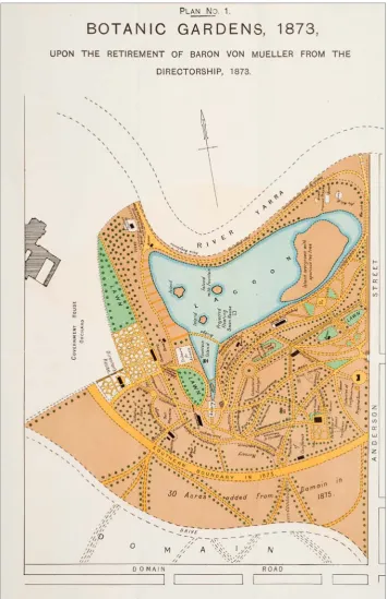
The gardens were founded in 1845, with the site selected by Superintendent (later Lieutenant-Governor) Charles Joseph La Trobe (1801–1875). Ferdinand von Mueller, who was appointed as Government Botanist in 1853, became director of the gardens in 1857 (Aitken & Looker, 2002). His directorship of 16 years marked a significant era in garden policy, which emphasised the scientific arrangement
and display of plants for the purposes of expanding knowledge and for economic
8
h a n n a h l e w i , a n d r e w s a n i g a , w a l l y s m i t h
proceeding in faltering starts, and von Mueller was dismissed in 1873, although he continued to work in the park’s herbarium until his death in 1896. Regardless
of the later radical transformation that would be brought upon the european
sensibility von Mueller had established, it was his influence in clearing the land
and curating a vast collection of plants that set down the crucial vegetative frame
that subsequent directors would build on (Figure 2a).
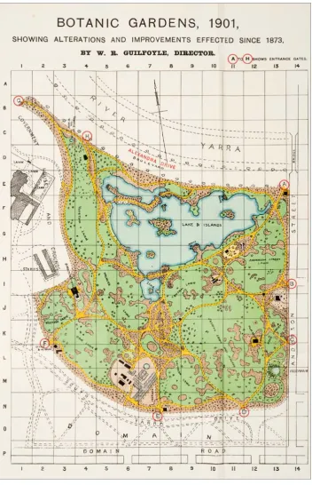
William Guilfoyle was appointed as the next director in 1873. He set about transforming the gardens into a landscape underpinned by a new design approach;
one that appreciated aesthetic (and recreational) values as much as it did the
Figure 2a: Royal Botanic Gardens, Melbourne, plan of alterations and additions under the direction of Ferdinand von Mueller, 1873.
9
h a n n a h l e w i , a n d r e w s a n i g a , w a l l y s m i t h
scientific. The fundamental transformation involved transplanting great numbers of trees of all sizes and creating wide, curvilinear paths with lawns and clusters of plants that replaced the straight, narrow paths lined with trees and spotty planting that had resulted from von Mueller’s years as director (Pescott, 1982).
guilfoyle advanced the propagation and acceptance of australian native
plants (Guilfoyle, 1909) while simultaneously establishing a picturesque quality with the inclusion of rustic ornaments and follies, whose visual qualities arose from Guilfoyle’s broad personal experience of exploring colonial frontiers.8
Finally, as a consequence of an ambitious engineering project to straighten the Yarra River, the major tributary upon which Melbourne was established, Guilfoyle
Figure 2b: Royal Botanic Gardens Melbourne plan of alterations and additions under the direction of William Guilfoyle, 1901. Source:
10
h a n n a h l e w i , a n d r e w s a n i g a , w a l l y s m i t h incorporated the severed portion of the yarra river into an enlarged ornamental
lake that, once beautified, became a focal point for the gardens (Figure 2b). Guilfoyle’s contributions persist to the present day, and the thematics can be explored in plant material, path alignments, structures and the views and vistas created by landform and the centrally located ornamental lake (Watts, 1983, p 62). The scale of these topographic works, combined with the substantial road and earthworks around the river, is reflective of public park-making in the mid-nineteenth century around the world, with places such as Central Park in
new york and parc des Buttes chaumont in paris illustrating how marginal sites
were transformed for public recreational use. Toward the end of the nineteenth century, the RBGM also provided the impetus for sweeping changes in a bid to beautify Melbourne around the time of Australia’s federation. In the early years of the twentieth century, the area between the gardens and river front was
formalised with the laying out of avenues and gardens and construction of several
commemorative imperial statues (Whitehead, 1997, pp 52–62).
The radical nature of changes to the rBgM in the latter half of the nineteenth
century, along with the wealth of archival material on von Mueller and Guilfoyle’s directorships and the Yarra River’s engineering at this stage in history, provided the motivation for interpretation in the context of landscape architectural education.9 pivotal was the need to inculcate sensitivity and inquisitiveness around how to
define ‘landscape’ in all its complexities. As JB Jackson argued, landscape is:
… a space deliberately created to speed up or slow down the process of nature … a composition of man-made or man-modified spaces to serve as infrastructure or background for our collective existence [underscoring] not only our identity and presence, but also our history (1984, p 8).
Thus, by using the guide, students were exposed to the idea that agency in the creation of landscape is not confined to the strictures of professional identities,
and that engineering and related practices and contingencies often carry equal
weight in producing a designed urban landscape. The approach taken in the
guide was to present selective threads of the rBgM’s history through audio
narration, text and a timeline, without attempting to reconcile them into a readily consumable singular narrative. Rather, it was left for the student visitors
to encounter and make sense of the changing landscape and to try to reconcile the disparate forces at play: some were the product of design and others a result
of entropy and evolution of landscape. In this sense, the guide attempted to make change over time visible while moving through the landscape.
choreographed experience
In considering motion as an important element of eidetic experience, we return to the core design challenges of the iPad tour. As identified above, these involved
how to immerse and inform the visitor and how to present design intentions and
discontinuities in the landscape as a historical record. A third challenge was how to
achieve these aims in the context of moving and guiding through large-scale sites
like the RBGM, which usually involve choreographed walking and viewing. This act of moving through a landscape has been identified as formative to creating an
11 h a n n a h l e w i , a n d r e w s a n i g a , w a l l y s m i t h
narratives of meaning embedded in a landscape by its designers (Conan, 2003a). However, although this close association between gardens and motion is taken as a given, Michel Conan, in his book Landscape Design and the Experience of Motion, asks why there is still relative silence regarding the experience of motion in contemporary landscape design writing. He suggests our understandings and descriptions of motion itself are still inadequate or illusive: ‘[T]he motion of the
traveler does not seem to open aesthetic appreciation in picturesque literature’
(Conan, 2003b, p 300).10
John Dixon Hunt (2003) has partially responded to Conan’s provocation in his analysis of movement in gardens over time. Hunt categorises three kinds of
movement that can be found in historical gardens and other designed landscapes:
the procession or ‘ritual’; the ‘stroll’; and the ‘ramble’ (2003, p 188). These informed the conceptualisation and design of navigation in the guide.
a procession implies ritualised movement that follows a preordained path
or purpose. It is prescribed and so it is repeatable and, indeed, is expected to be repeated. The route is encoded in some manner – whether through a formal guide, designated paths, onsite signage or accompanying guides.
The ritual experience of the procession is likely to be undertaken by a group, perhaps with set aims to be accomplished. Within the European tradition, Hunt offers the example of the gardens of Versailles, as narrated by Madeleine de Scudéry in 1669, and later by Louis XIV’s guided tours (2003, p 291). Also, the garden of Stowe in Buckinghamshire, England, is seen as a somewhat ritualistic experience, where visits since the mid-1700s were guided by detailed guidebooks
that helped draw together the many built and natural elements of the garden
into a narrative sequence (Hunt, 2003, p 202). As evidenced by Hunt and other accounts of garden appreciation, the formalised guiding of movement around
designed landscapes and gardens through guidebooks and similarly organised means has a sustained history upon which many recent digital reincarnations
build (Richardson, 2007).
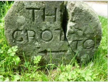
The ‘stroll’ and the ‘ramble’ occur where visitors give themselves over more to the individual sensation of movement. They are, therefore, less purposefully directed than the ritualised procession. Strolls are marked by incidents that ‘punctuate and give rhythm to the movement’ (Hunt, 2003, p 188). As exemplars of historical strolling sites, Hunt offers the ancient strolling gardens in the Chinese tradition, and picturesque gardens in the European tradition. Strolls are also defined by material incentives, but not prescriptions, to move forward in the landscape, as found in the lakeside route famously created by Henry Hoare at the garden of Stourhead in Wiltshire, England. Stourhead set a fascinating precedent in guiding experience through induced movement and looking, as embedded fundamentally in the gardens itself, including the careful placement and sequencing of statues, follies and landscaped elements, and stone signs inscribed with poetic directions to the visitor (Figure 3).
12 h a n n a h l e w i , a n d r e w s a n i g a , w a l l y s m i t h
Categorisations are useful but never tidy. As Hunt acknowledges, many gardens
cater for at least two kinds of movement – the processional guided tour in groups
with allowance for, and indeed promotion of, informal and singular strolling. For example, paintings and drawings of the gardens at Chiswick House in London
commissioned by the owner Lord Burlington show groups of guests experiencing
the gardens through both defined pathways and guided tours. But they also show figures obviously deviating from these prescriptions and undertaking their own exploration; and this was apparently encouraged (Hunt, 2003, p 206).
At Alexander Pope’s garden, designed by William Kent in Twickenham, England, while visitors might have been invited for a formal guided experience
by the owner or designer they were also encouraged to follow personal curiosity
by exploring the gardens over the course of an extended stay. Hunt describes this mixed experience as a ‘middle mode’ (2003, p 207). He also alerts us to the changing status and interpretation of such garden journeys over time, according to shifts in both narratives of design intention and use (2003, p 213). The intention of the self-directed stroll, for example, can become ritualised or more programmed over time, often through conscious heritage and public educational strategies and agendas.
our research included surveying an archival collection of picture postcards (photographic and wood engravings) held within the state Library of victoria that depicted mid-to-late nineteenth and early twentieth century views of people in the
RBGM. Although these scenes are static representations, they provide extensive
illustrations of people strolling along broad gravel paths and vistas framed by
exuberant vegetation, topography and flowing swathes of lawn and water. One immediately notices the finery – the parasols and special attire – and the implied actions of promenading, looking or pointing, clusters of people roaming and observing the cultivated scenes or natural objects. These images show the value
13 h a n n a h l e w i , a n d r e w s a n i g a , w a l l y s m i t h
placed on strolling through a picturesque setting, a tradition clearly inherited from England and the United States and supplanted into the colonial setting, but one that continues to have relevance today.
The tour of the rBgM was conceived as a programmed walk for small groups
of students in a prescribed journey around a carefully edited and selected part of the site. The journey’s content was based on a personalised tour that had been led by Andrew Saniga in the RBGM over several years. So it adhered, in part, to the
tradition of ritualised processional guiding – both as a mode of experience and
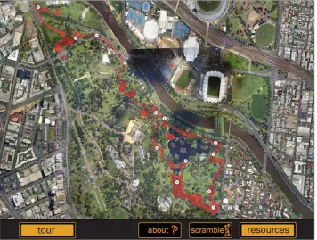
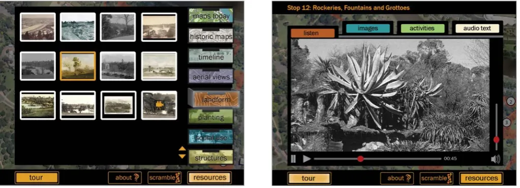
as a digital design metaphor. As a design metaphor for organising the iPad guide, a fairly tight choreographed route was defined, with 13 stops in the RBGM and King’s Domain. However, within this route was a suggestion of loose exploration as depicted by a red ‘lava-like’ flow that links the stops together rather than a sharp line of movement (Figure 4). The use of GPS tracking, in the form of a yellow dot on the guide’s map to indicate current position, was also included to encourage more free exploration with the security to reorient when required.11
Each stop included text narration by Saniga, as the tour guide and subject lecturer, accompanied by images related to the location. The route’s itinerary was scripted with limits on time and stamina in mind, and therefore only locations
that could most directly illuminate particular historical or design themes were
highlighted. No narration or information was given between the 13 stops.
Movement was therefore guided in a somewhat staccato fashion, and perhaps thereby fell into the criticism offered by Stephen Bann that landscaped sites are
generally described throughout history as a series of still points rather than a
constant flow of moving and looking (2003, p 53). However, in addition to this programmed guiding through a set route, the tour aimed to promote a less structured and sequenced experience, reminiscent of Hunt’s ‘middle mode’ that combines the stroll and procession. So while students followed a predefined
14 h a n n a h l e w i , a n d r e w s a n i g a , w a l l y s m i t h
scale procession through the 13 stops, they had freedom to stroll in and around the vicinity of each stop. This movement is embodied both in how the gardens can be physically experienced and moved through, and through the intended virtual navigation of the iPad guide. Aside from the mapped tour with designated stops, a series of thematic resources, gathered and presented in ‘drawers’, allowed users to wander and pursue archival territories of personal interest.
To provide further navigational choice and promote longer use of the guide, either at or away from the park, a ‘Scramble’ function was included that was inspired by the possibility of more radically mixing up the guided experience. A series of sound bites cut from the stop narratives, video and still images was collaged together for playing at leisure. The Scramble function was not intended to didactically guide but to create an ‘ambient’ backdrop for exploring on one’s own, and perhaps even to induce more random-like wanderings that evoke the spatial and material qualities of the park and historical episodes that created it.
Paul Carter has described the mode of collage as a legitimate or ‘normal’ way
of tackling representation of knowledge and place in a post-colonial setting:
‘collage as a compositional technique is … to imitate things as they are and, what’s more, to mirror them without any obvious addition of meaning’ (1992, p 186). The goal of collage in this context is to ‘decompose’ straightforward linear and
direct associations and interpretations and so is apt for the interpretation of a
European-styled park in an Antipodean urban setting.
The scramble option alludes to this messiness of historical interpretation:
of unfinished plans and unrealised ideas that are inherent in the making of any layered place over time. It also mimics familiar digital modes such as the ‘screensaver’. Plus, in the same way that the random appearance of an image or a sound can lead to serendipity and forced connections, it was thought that Scramble may lead to the invention or multiplication of narratives and, ultimately, the possibility of ideation. Put another way, Scramble encouraged
the students to develop their own interpretive framework from a combination
of historic data and varied geographic contexts. This outcome supports Gardner and Harfield’s (2014) claim that the new era of mobile devices can be relational and the ‘personal interpretive framework becomes one that is largely determined by, and contingent on, movement through urban space’ (p 202). Alternatively, and perhaps more pragmatically, Scramble also allowed for a more circumspect use of the iPad tour, one that could exist in the background should a user wish to give their primary attention to the site itself and less to the mediation of the iPad.
demonstrating historical time through images
To return to broader questions on representing historic landscapes, Casey (2002) has described the historical difficulties faced in encapsulating and presenting experience of designed landscapes and gardens that, in turn, gave rise to
interesting and experimental images such as the panoramic and topographical
15 h a n n a h l e w i , a n d r e w s a n i g a , w a l l y s m i t h
the challenges of presenting landscapes through time, Casey (2002) analyses an
eclectic variety of examples including: carleton watkins’s photographs capturing
the sublimity of Yosemite Park in the United States; John Constable’s intimate paintings of the region of Dedham Vale in England; and the tradition of the
vertical and horizontal chinese scrolls showing chinese landscapes from the
Northern Sung period.
The possibilities afforded by digital and mobile technologies offer new twists to this field of landscape presentation, demonstration and explication. Through the digital guide we were interested in testing how easily different types of images and maps could be read and what they would offer or hinder in terms of the immersive and informative experience. At each of the 13 stops, a selection of images and films accompanies the narration and directs users to look at various features and views.
To take a few stops as examples, the first is titled ‘Straightening the River’ and locates the beginning of the tour at the plaque of the RBGM directors. The first contemporary image in each stop serves as a ‘you are here’ indicator.
At Stop 1, users are directed to look at the rock escarpment that rises before them as a relic of what was once the edge of the Yarra River. Frequent flooding prompted mitigation work between 1896 and 1900, and the Yarra River was straightened, thereby creating the causeway of Alexandra Avenue. This sliced-off body of water became an enlarged lake in the botanic gardens, and so transformative was this feat of engineering that, without the supplementary archival photography and maps in the mobile guide, users would almost certainly be unable to detect these topographical changes in the landscape before them. The first image depicts the engineering of the new course for the Yarra River and its excavation in 1898, including a boulevard complete with street tree planting already under way.
subsequent images taken from roughly the same location go back and forward
in time (to circa 1870 and 1917 respectively) allowing direct comparison of the Yarra River’s course and its associated landscape embellishments. Detailed images of the excavation work, and a Department of Lands and Survey plan, indicate the engineering changes. Perceptual processes mix with the cognitive, providing the
potential to see and realise how time has managed to obscure the magnitude of
the historic earthworks. The rock escarpment, once worn into existence by the flow of the Yarra River, is now subject to another equally compelling form of gradual decay in its life as an ornamental garden feature. The escarpment faces
weathering and erosion as it becomes subsumed in cultivated plants and retained
soils and as its geological structure is undermined by their roots.
16 h a n n a h l e w i , a n d r e w s a n i g a , w a l l y s m i t h
Imagine yourself in Central Park one million years ago. You would be standing on a vast ice sheet, a 4,000-mile glacial wall, as much as 2,000 feet thick. Alone on the vast glacier, you would not sense its slow crushing, scraping, ripping movement as it advanced south, leaving great masses of rock debris in its wake. Under the frozen depths, where the carousel now stands, you would not notice the effect on the bedrock as the glacier dragged itself along … Back in the 1850s, Frederick Law olmsted and calvert vaux considered that glacial aftermath along its geological profiles (Smithson, 1973, pp 157–158).
At Stop 3, images of the Separation Tree and rest house in 1909 allow comparison with how the site appears today (figures 5a and 5b). This stop was chosen to
provoke consideration of the clash between colonial history and the indigenous
presence before the gardens were established. The intention was to prompt this through experience and explanation of the ‘Separation Tree’, which is far older than white settlement but was named in 1850 as the site of celebration of the colony of Victoria’s separation from New South Wales.
The narration reminds guide users of the importance of this setting to the
people of the Kulin nations as a food resource and meeting place.13 The user is then
pointed to the rest house nearby as an example of the kinds of timber structures
constructed throughout the gardens. Often, in von Mueller and Guilfoyle’s time as directors, structures and rustic ornaments such as the timber seat within the
rest house were made with timber from indigenous trees and shrubs cleared from
the gardens. Here, physical residues from both colonial and Aboriginal histories are conflated in the construction of a picturesque garden design. The result opens up the possibility for a new reading of this space, in a way partly echoing the
sentiment behind what grant revell describes in collaborative teaching
experiences as ‘the third space’. This is a learning environment where ‘design
students and their respective indigenous collaborators are able to share and
understand these critical histories, and accompanying values’ (Revell, 2001, p 15). It is the act of allowing users to position their body – to sit within a space
that manifests this history – that provides the opportunity to mentally unpack
what they see before them and feel beneath them.
At Stop 5, archival photographs and sketches from Fiji are presented, illustrating Guilfoyle’s design influences for his vision of the garden landforms
Figure 5a (left): The Separation Tree and rest house, postcard, 1909 (State Library of Victoria).
17
h a n n a h l e w i , a n d r e w s a n i g a , w a l l y s m i t h
and plantings. This stop locates the user at ‘Guilfoyle’s volcano’, which includes
a recent reconstruction based on guilfoyle’s original design for a water reservoir
in the form of a crater-like volcano. Guilfoyle’s volcano was intended to be reminiscent of his experiences on plant-collecting expeditions in the South Pacific in the late 1860s (Fox, 2004, pp 135–137) (see Figure 6).
From the available historic photographs, the original design around the time
of construction consisted of a large earthwork much like a volcanic crater with
bare earth walls. The surrounding garden beds and rockery represented the substance of volcanic islands, with lawns occupying the space in between and aiding the illusion of a flow of lava (Pescott, 1982, p 118). In Guilfoyle’s day, when viewing the volcano from the distant Government House, the smoke from the adjacent wood-fired furnaces of the conservatory (now gone) created the sense that this simulated volcano was indeed still active (Fox, 2004, p 137).
Within the palette of Victorian gardening styles, Guilfoyle’s metaphor
represented the special qualities of natural places as discovered through colonial
experience in the nineteenth century. Yet it draws upon European traditions of picturesque follies, kinetic sculptures and the choreographed spaces of grottos. As John Dixon Hunt has extensively shown with examples like the imperial hunting lodge of Laxenburg in Austria, such design interventions could ‘elicit a
full range of responses [including] historical association … melancholy … peaceful
reflections … exotic fancies … or simple satisfaction …’ (2002, pp 173–174). The
recent reconstruction of the volcano was driven by landscape architect andrew
Laidlaw. It consists of dry gardens and expansive cacti planting in a bid to exhibit water-saving landscape design. The coloured bituminous concrete-paving design graphically mimics the patterns of a lava flow. Given the markedly different treatment to what originated in Guilfoyle’s time, the archival materials within the iPad tour allow the contemporary viewer to identify significant changes over time.
Figure 6: Guilfoyle’s design inspiration
was partly drawn from his fieldwork in the South Pacific and this influenced
18
h a n n a h l e w i , a n d r e w s a n i g a , w a l l y s m i t h
In addition to the 13 stops, the iPad tour contains other documents accessible as a series of resource drawers in the taxonomy of: contemporary contour maps; key historic maps; a basic timeline; aerial views over time; and a series of archival images (paintings, photographs, sketches, postcards and films) organised under the themes of landform, planting, and social use and structures (Figure 7). The collections aim to help capture how the park has been used over time. In terms of the presentation of these resources, other considerations came into play such as the technical surface of reproduction, the size and framing and where it is viewed, or what Casey has termed the ‘place-of-exhibition’ and ‘place-of-surface’ (2002, p 120). In the digital mode, the framing and scale of images and film are constrained by the screen size of the iPad, but the format is, without doubt, easier
to reproduce and manipulate in a variety of ways than conventional guidebooks
and printed resources (Figure 8).
conclusions: The challenges of immersive and
informative experience
In designing and evaluating an iPad tour for the RBGM, one motivating question was what, if anything, might be new about this emerging digital form of guided landscape touring? As shown in this paper, on the surface, the digital guide delivers information in a format that differs from the approach of the human guide and the guidebook. Importantly, it provides a virtual environment for
information to be explored and navigated in tandem with the experience of the
physical place. At a deeper level though, as demonstrated in this paper, this new
format is responding to longstanding and familiar issues in the visitor’s encounter
with historic landscapes.
As with other interpretive devices in museum environments, the extent to which the user seeks an open-ended emotive response, and the extent to which the experience tends towards a more prescriptive cognitive one, is always going to be open to debate. The RBGM has earned an international reputation for its aesthetic qualities. Likewise, the emotional or psychological ‘pull’ the site wields
in the geography of Melbourne no doubt interplays with the user’s experience
in ways so complex as to elude quantification. It was certainly not the intention in this research to engage in the field of environmental psychology but rather to
Figure 7 (left): ‘Landscapes in Time’, typical ‘stop’ page (authors, 2011).
19
h a n n a h l e w i , a n d r e w s a n i g a , w a l l y s m i t h
accept such interplay exists in a manner perhaps best described as ‘experiential gestalt’ (Nettleton, 1990). That is, the experience involves a combined set of schema including cognition, perception, emotion and fantasy, all of which the iPad tour seeks to trigger. Ultimately, the iPad tour was made for design students,
and the expectation is that studying the past may inform the development of their
own proficiencies as designers capable of generating new ideas.
on the question of how digital guides may choreograph movement and
experience through designed landscapes, we refer back to Hunt’s (2003) historical schema of movement types. The iPad tour recreated something of a ‘procession’:
the ritualised route inscribed activities to be completed by the students with a
clear goal at the outset.14 At the same time, having never taken this route before, and in the absence of a knowledgeable human guide, the students’ experience was also that of the self-motivated stroll, depending on their will to proceed at each point and punctuated by defined points of interest (Figure 9).
As established in this paper, another issue confronted by the digital tour guide concerns the demonstration of historical time and relates to Casey’s (2002) distinction between presentation and representation. The individual items of content exhibited in our guide drew on various genres – photographic images, maps and films – that depicted garden views at various historic moments. When they are deployed within the iPad tour as the ‘place-of-exhibition’, we suggest that these exhibits align with Casey’s (2002) notion of presentation and demonstration rather than representation, with an emphasis on synchronous comparison and interpretation conducted in situ. Thus, resources that might serve as merely representative copies when viewed elsewhere, here become tools of ‘directed looking’ and interpretation when synchronised with their real counterparts in context. While such juxtaposition is possible with guidebooks and common enough with fixed sign boards, it is the unexpected appearance and
vivid alignment with the physical scene as the visitor moves through the site that
characterises this particular comparative experience.
20
h a n n a h l e w i , a n d r e w s a n i g a , w a l l y s m i t h
In conclusion, many productive precedents are found in modes of touring
and presenting gardens in the past that remain instructive in addressing anew
the challenges of offering both an immersive and personalised experience alongside an informative guide to a designed landscape. For example, to revisit the extraordinary stone signage at the garden of Stourhead in Wiltshire, England, Michael Charlesworth suggests these inscriptions ‘invite the visitor across a crucial
threshold that separates the mythic domain of the garden from real space …’
(2003, p 285). It is this motif of the ‘inscription’ (whether instructive or poetic) as a guiding voice that has persisted in many modes of garden experience and, arguably, makes us feel differently within designed gardens ‘compared to how we feel in other “everyday” spaces’ (2003, p 285). Even within the formal task of university fieldwork, we ultimately wanted students to benefit from the more didactically illustrated experience of ‘historical’ time, as offered by the resources in the iPad guide, but also to retain some semblance of the personal and perhaps even the poetic experience of their own time spent in the gardens (Figure 10).
This paper has described how the creation of a mobile digital guide for a particular designed landscape and its history presented challenges that were
linked to centuries of attempts to guide visitors around designed landscapes. It is also perhaps not much of an exaggeration to state that the attempt to design,
build and implement a mobile digital guide for the rBgM encountered the
same fundamental issues inherent in designing a landscape itself. That is not to conclude that digital mobile guides bring nothing new to historic landscapes, for they introduce increased volumes of content, ready access to rich and vivid images and film collections, connectivity and location-aware functions. These all bring new opportunities. At the same time, the guides continue the lineage of shaping the productive exchange between people and landscapes.
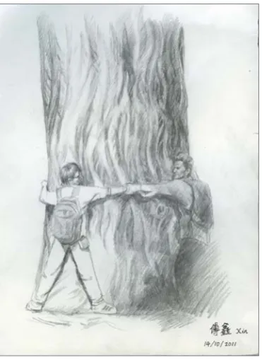
Figure 10: Student and lecturer hugging a tree in the Royal Botanic Gardens Melbourne, a teacher’s ploy to encourage students to engage with their context. Xin Fu, Master of Landscape Architecture student, University of Melbourne, drew the event to illustrate
21 h a n n a h l e w i , a n d r e w s a n i g a , w a l l y s m i t h
acknowledgements
The creation of the ‘Landscapes in Time’ digital guide was funded by the University of Melbourne and the Office for Learning and Teaching Australia.
Material was made available through the archives of the rBgM and the state
Library of Victoria. The digital guide was designed, authored and programmed by the authors and Jacqueline Monie from the University of Melbourne and Daniel Trembath. Thank you to the reviewers of this paper for their comments and suggestions.
noTes
1 Studies of the teaching and learning objectives and findings have been published elsewhere and are covered in the project website. To access, see
http://mobilefieldworklearning.wordpress.com
2 To access, see www.imamuseum.org/blog/2010/06/07/going-mobile
3 To access, see www.nybg.org/exhibitions/2012/monet/index.php
4 John Weber describing the work of Janet Cardiff (‘The Telephone Call’, 2001) at: www.cardiffmiller.com/artworks/walks/telephonecall.html
5 The issues of socialised learning using mobile technology have generated a growing
field of educational technology scholarship. This is engaged with in other accounts
we have written and covers the process of implementing mobile apps for higher
education teaching and learning, but falls outside the historical scope of this paper. 6 For other studies on the iPad format see, for example, Lewi and Smith (2012). 7 The expansiveness of the King’s Domain and its associated topographic richness
mean that one’s sense of orientation, movement and location is correspondingly reliant on landmarks and maps for way-finding. To an extent, our research involved
contemplation of cognitive maps as a record of the experience of landscape and as a
central driver in formulating the route of the walk.
8 For example, Guilfoyle designed a new water reservoir in the shape of a volcano, and the neighbouring rockery, garden beds and lawn were laid out to represent the materiality of volcanic islands and lava flows. He had formed such imagery when he travelled to islands in the South Pacific.
9 Under subsequent directors throughout the twentieth century, the design foundations set in the nineteenth century were largely perpetuated.
10 Adding to this is the complex task of capturing a more nuanced, subjective and
gendered understanding of the experience of the contemporary moving body in a
historic setting such as a public garden.
11 Curiously, though, it was those students who were not given the GPS marker who appeared to interrogate the space more actively and construct their journey. Those with GPS seemed to move more slavishly to the prescribed route.
12 The authors refer here to robert smithson’s important contributions to earthworks
and art practice in the 1960s and that have been generated from Smithson’s writings on this topic (see Smithson and Sky, 1973).
13 When Melbourne became a self-governing city in 1842, new policy was formed that resulted in the progressive exclusion of Indigenous people from white society. This continued to be enacted concurrently with the first park directorship under the scientist Ferdinand von Mueller.
14 As noted above, the inclusion of GPS seemed to strengthen this processional
experience by allowing the group to follow the track with little deviation or inclination
22 h a n n a h l e w i , a n d r e w s a n i g a , w a l l y s m i t h
BiBLiograpHy
Aitken, R and Looker, M (2002) The Oxford Companion to Australian Gardens, Melbourne, Victoria: Oxford University Press.
Bann, S (2003) Sensing the Stones: Bernard Lassus and the Ground of Landscape Design. In
Landscape Design and the Experience of Motion, M Conan (ed), Washington, DC: Dumbarton Oaks. Carter, P (1992) Living in a New Country: History, Travelling and Language, London: Faber & Faber.
Casey, E (2002) Representing Place: Landscape Painting & Maps, Minneapolis: The University of Minnesota Press.
Charlesworth, M (2003) Movement, Intersubjectivity, and Mercantile Morality at Stourhead. In
Landscape Design and the Experience of Motion, M Conan (ed), Washington, DC: Dumbarton Oaks. Cochrane, TD (2010) Exploring Mobile Learning Success Factors ALT-J, Research in Learning Technology, 18(2), pp 133–148.
Conan, M (2003a) Introduction: Garden and Landscape Design, from Emotion to the Construction of Self. In Landscape Design and the Experience of Motion, M Conan (ed), Washington, DC: Dumbarton Oaks.
—— (ed) (2003b) Landscape Metaphors and Metamorphosis of Time, Landscape Design and the Experience of Motion, Washington, DC: Dumbarton Oaks.
Corner, J (ed) (1999) Eidetic Operations and New Landscapes, Recovering Landscape: Essays in Contemporary Landscape Architecture, New York: Princeton Architectural Press.
Downs, RM and Stea, D (1977) Maps in Minds: Reflections on Cognitive Mapping, New York: Harper and Row.
Fox, P (2004) Clearings: Six Colonial Gardeners and their Landscapes, Carlton, Victoria: The Meigunyah Press.
Gardner, N and Harfield, S (2014) Great Expectations: Mobilising Histories and Transforming the City through Mobile Technology Practices. In UHPH_14: Landscapes and Ecologies of Urban and Planning History: Proceedings of the 12th Australasian Urban History Planning History Conference, M Gjerde and E Petrovic (eds), Wellington: Australasian Urban History/Planning History Group and Victoria University of Wellington, pp 195–212.
Guilfoyle, WR (1909) Australian Plants Suitable for Gardens, Parks, Timber Reserves, etc, Melbourne: Whitcombe and Tombs Limited.
Hall, S (2004) I, Mercator. In You are Here: Personal Geographies and Other Maps of the Imagination, K Harmon (ed), New York: Princeton Architectural Press.
Hunt, JD (2002) The Picturesque Garden in Europe, London: Thames and Hudson.
—— (2003) Lordship of the Feet: Toward a Poetics of Movement in the Garden. In Landscape Design and the Experience of Motion, M Conan (ed), Washington, DC: Dumbarton Oaks. Jackson, JB (1984) Discovering the Vernacular Landscape, New Haven and London: Yale University Press.
Kinash, S, Brand, J and Mathew, T (2012) Challenging Mobile Learning Discourse through Research: Student Perceptions of Blackboard Mobile Learn and iPads, Australasian Journal of Educational Technology, 28(4), 639–655.
Lewi, H and Smith, W (2012) Hand-held Histories: Using Digital Archival Documents on Architectural Tours, Architecture Research Quarterly, 15(1): 69–77.
Nettleton, B (1990) Health, Emotions and Nature. Unpublished paper, School of Environmental Planning, University of Melbourne, Melbourne, Victoria.
Pescott, R T M (1982) The Royal Botanic Gardens Melbourne: A History from 1845 to 1970, Melbourne: Oxford University Press.
Pfeiffer, V, Gemballa, S, Jarodzka, H, Scheiter, K and Gerjets, P (2009) Situated Learning in the Mobile Age: Mobile Devices on a Field Trip to the Sea, ALT-J Research in Learning Technology, 17(3), pp 187–199.
23 h a n n a h l e w i , a n d r e w s a n i g a , w a l l y s m i t h
Richardson, T (2007) The Arcadian Friends: Inventing the English Landscape Garden, London: Bantam Press.
Sharples, M, Taylor, J and Vavoula, G (2005) Towards a Theory of Mobile Learning. In Mobile Technology:The Future of Learning in Your Hands, mLearn 2005 Book of Abstracts, 4th World Conference on mLearning, Cape Town, 25–28 October, H van der Merwe and T Brown (eds), Cape Town: mLearn, p 58.
Smithson, R (1973) [c1996] Frederick Law Olmsted and the Dialectical Landscape. In Robert Smithson: Collected Writings, J Flam (ed), Berkeley, CA: University of California Press (originally in Artforum, February 1973).
Smithson, R and Sky, A (1973) [c1996] Entropy Made Visible: Interview with Alison Sky. In Robert Smithson: Collected Writings, J Flam (ed), Berkeley, CA: University of California Press.
Vavoula, G, Pachler, N and Kukulska-Hulme, A (eds) (2010) Researching MOBILE Learning: Frameworks, Tools and Research Designs (2nd edn). Bern, Switzerland: Peter Lang AG, International Academic Publishers.
Watts, P (1983) Historic Gardens of Victoria: A Reconnaissance, Melbourne, Victoria: Oxford University Press.
24 L a n d s c a p e r e v i e w 1 5 ( 1 ) p a g e s 2 4 – 4 6
Brent Greene is a PhD candidate at the University of Melbourne, Faculty of Architecture, Building and Planning, The University of Melbourne, Victoria 3010, Australia.
Email: [email protected]. edu.au
Heike Rahmann is a Lecturer in landscape architecture, RMIT University, School of
Architecture and Design, PO Box 2476, Melbourne, Victoria 3001, Australia. Email: [email protected] Key words Third landscape Landscape infrastructure Urban design Urban ecology Design research
glitterosophy: The good, the Bad
and the Ugly
brent greene and heike rahmann
reflection
Urban renewal projects in australia are increasingly favouring the creation of new, sleek and conform design outcomes. with few exceptions, most projects approach sites as ‘terra nova’: they eliminate pre-existing ecological and cultural conditions and replace unappreciated features with generic but generally appreciated solutions. This paper criticises these developments and argues that the destruction of interstitial qualities purges cities of ecological, architectural and cultural conditions that could be built upon to generate more diverse urban landscapes. recent theories in urban design, art and culture have started to express a growing interest in the concept of the other and the marginalised. Most notable in this discussion is French landscape architect gilles clément’s concept of the ‘third
landscape’, which aims to redefine the aesthetic value of interstitial environments.
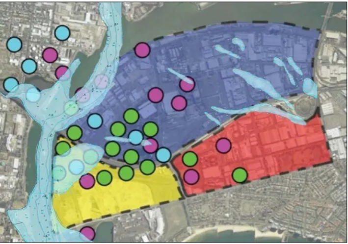
This paper uses clément’s framework as a starting point to explore alternative approaches to issues of contemporary urban renewal and the potential of remnant vegetation as a counterbalance to the increasingly homogenised urban landscape. Through the lens of weeds, issues of aesthetics and otherness are explored across two case study projects: Fishermans Bend in Melbourne and sullivans creek in canberra.
The exploration is based on a design research methodology that includes
composite mapping and testing of a speculative design proposal. The findings
suggest that invasive plant species are imperative constituents of contemporary urban space and have value in their own right. By shifting the design perspective to acknowledge the presence of interstitial ecologies in the built form, a foundation is provided from which a progressive landscape aesthetic supporting diversity over homogeneity can evolve.
a
ustralian landscape architecture’s traditional design language is one of restorative beauty and ornamentation, which evolved from the formative years of the profession and focused on the distinct qualities of the australian landscape (saniga, 2009). although local architecture has endeavoured to shedits fascination with the beautification of structures, landscape architecture
continues to align itself with the ornamentation of public spaces through highly synthetic representations of nature. contemporary design theory challenges this perspective and suggests that human beings, in conjunction with landscape processes, continually rework their environments (solnit, 2007). The resulting issue is that what we perceive as ‘natural’ often stands in opposition to how environments evolve and is based entirely on what a culture determines as beautiful and ugly, worthy and worthless (ibid, p 278).
25 b r e n t g r e e n e a n d h e i k e r a h m a n n
Otherness is used in this paper to describe the following landscape features: pioneer plant species, redundant architecture, infrastructural landscapes and minority cultures. The paper asks if the practice of engaging with otherness through design can provide an opportunity for challenging traditionalist perspectives of landscape aesthetics in the city. The question is based on the studies of French landscape architect gilles clément who explores otherness in
the landscape through a design philosophy that he defines as the ‘third landscape’
(cited in rocca, 2008, p 27):
it includes leftover territory, both rural and urban, and untilled zones: the edges of roads and fields. Of industrial areas and nature reserves. It is the space of indecision, and the living things that occupy it act freely. To see the third landscape as a biological necessity that influences the future of living things modifies our interpretation of territory, attributing value to the places that are normally neglected.
Clément’s philosophy is based on two principles. The first acknowledges the
ecological value of alternative urban space. The second reveals our own cultural perception of these spaces and aims to challenge the status quo of neglect. while other urban landscapes are often defined as ecologically subordinate when
compared with naturally evolved landscape artefacts (Katz, 1993), clément reveals their innate beauty by designing alongside them complex environmental systems. This design move allows the landscape to transcend its visual aesthetic by celebrating interstitial ecologies as one component in a larger dynamic process. Theories on contemporary landscape aesthetics argue it is this dynamic process – and not visual character alone – that should inform our landscape
sensibilities. Saito (2007), for example, suggests that urban spaces of insignificance
should establish a progressive aesthetic value in relation to ecology and culture. Berleant (2005, p 14) continues that experiencing these spaces:
… enables us to grasp the environment as a setting of dynamic forces, a field of forces that engages both the perceiver and perceived in dynamic unity. what is important are not physical traits but perceptual ones, not how things are but how they are experienced.
as such, Berleant (2005) outlines a methodological framework that expands the perception of the other in urban landscapes into a tangible and adaptable form. This may be regarded as a leap forward from traditional landscape aesthetics (carlson, 2010).
These conceptual advances have moved into a range of international landscape design projects that challenge the traditional aesthetics of urban landscapes. new york’s High Line (opened in 2009), for instance, uses existing ‘weedy’ seed stock for development through planting schemes. another example is HuaXin city (developed in 2004) in the shanghai metropolitan region where german ecological engineer specialists Janisch and schulz converted the city’s existing labyrinth-like canal system into a linear wetland. primarily designed as a wastewater management facility, the canals also act as open space and valuable plant and animal habitat.