2017 2nd International Conference on Computer Science and Technology (CST 2017) ISBN: 978-1-60595-461-5
Research on Three-dimensional Modeling Method of High
Speed Flying Object Based on Image
Sen ZHANG, Ting-ting YANG
a*, Yuan-heng ZHANG,
Chao JIN and Long-tao FAN
School of Information Engineering Henan University of Science and Technology, Luoyang, Henan Province, China
*Corresponding author
Keywords: High speed flying object, Open Flight API, OpenCV, Modeling automatically.
Abstract. Aiming at the three-dimensional modeling problem of dynamic objects, a fast modeling method of three-dimensional model of high speed flying object based on image was proposed. Firstly, using high-resolution CCD camera to obtain multiple images of flying object, and the image was processed by OpenCV to obtain the data information of the key point of the flying object. Secondly, create three-dimensional graphics by calling the Open Flight API library function and write the FLT file to generate the three-dimensional contour of the flying object. Finally, the model was refined to realize the three-dimensional reconstruction of the high-speed flying object. Through the comparison of examples, the proposed method can quickly and efficiently realize the reconstruction of three-dimensional model of high-speed flying object.
Introduction
Image-based modeling is a research hotspot in the field of computer graphics and computer vision. It studies how to use a variety of clue information in a single image, image sequence or video to restore a three-dimensional model of an object or scene. The technology has a wide application prospect in the field of intelligent human-computer interaction, digital special effects production, real-time monitoring and so on.
modeling; Reference [6] designed and realized the three-dimensional reconstruction system of striped structured light, using pixel index value as a medium for triangle network processing of the point cloud so as to achieve three-dimensional reconstruction of the model. In the conventional method, the time of computer CPU is too long and cannot meet the current requirements of development. The research on the automatic modeling technology of surface data information based on high speed flying object is still in the theoretical exploration stage.
In the present study, this paper presents an automatic modeling method of high-speed flying object based on image, according to image information extracted by CCD camera, calling the Open Flight API function, completing segmentation and automatic modeling of the image information of the flying object surface, requiring a three-dimensional model of the flying object. The method can reduce the running time of the computer, which provides a engineering reference for automatic modeling technology of surface information of the high speed flying object in the future.
The Model Structure of Open Flight
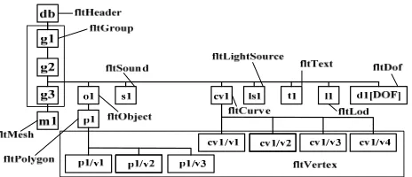
[image:2.612.189.421.359.459.2]Open Flight is a database defined by Multigen Corporation that is used to fully describe the visual simulation model. Open Flight format is a tree-like hierarchical structure, any of the elements in the scene can be quickly and easily edited, modified and controlled, which is suitable for real-time system to achieve a variety of traversal operations. Figure 1 shows the data structure of Open Flight.
Figure 1. The Open Flight hierarchical data structure.
The Open Flight API is a C programming language library that contains header files and link libraries that provide an interface to access the Open Flight database and the Creator model system. API can be used for the conversion of Open Flight model, real-time simulation, automatic modeling, and the expansion of the Creator function in the form of plug-ins.
The Acquisition and Processing of Image The Acquisition of Image
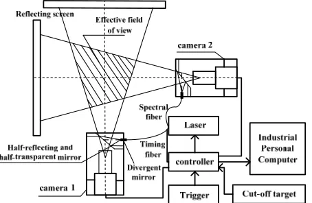
[image:3.612.196.423.192.340.2]The flying speed of the high-speed flying object is very high, the pitch angle, the yaw angle and the centroid is in the unceasing change, in order to carry out the three-dimensional reconstruction of the high-speed flying object, the image information of the object in different angles at the same time is needed. In this paper, two high-resolution CCD camera orthogonal image system is used to collect images, the structure of the system is shown in Figure 2.
Figure 2. The system diagram of two camera orthogonal scheme. Image Processing
Image Graying. The collected images of digital ballistic range shadowgraph system are RGB images, in order to extract the contour to the surface of high speed flying object, image graying is needed firstly, that is R=G=B=Y, there are a variety of
methods to calculate the value of Y, in OpenCV, cvCvtColor() function uses weighted
method to calculate the value of Gray so as to achieve the convert from color image to gray image. The value of the weight coefficient is as follows:
B G
R
Y =0.299 +0.587 +0.114 (1)
Where Y is the gray value, which ranges from 0 to 255. The gray image is shown in
Figure 3.
(a) The image of camera 1 (b) The image of camera 2 Figure 3. The image after graying.
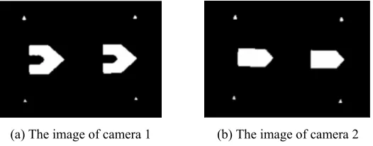
[image:3.612.170.439.529.632.2]between the gray value of the high-speed flying object and the gray value of the background image, this paper uses threshold segmentation algorithm to achieve image
binarization, the principle is assign each pixel of the gray image to the white (Y=255) or
black (Y=0) in a specific range, the mathematical model is:
< ≥ = t y x f t y x f y x g ) , ( 0 ) , ( 255 ) ,
( (2)
Where t is the threshold; g (x, y) is the binarized gray value; f (x, y) is the gray value before binarization.
The cv Threshold function in OpenCV can achieve the binarization operation for the gray image. Its principle is to compare each element in image array with set threshold to complete related processing, (2) can be achieved through threshold type selection of function, which can be expressed as:
0 : 255 ? )
(src t
dsti= i > (3)
Where dsti is the i-th pixel value after processing, srci is the i-th pixel value of the
original image, and t is the set threshold. Which is obtained by the function
cvThreshold, as shown in Figure 4.
[image:4.612.176.439.327.430.2]
(a) The image of camera 1 (b) The image of camera 2 Figure 4. The binarization image.
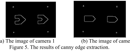
Surface Outline Feature Extraction of High Speed Flying Body. Roberts operator, Sobel operator, Prewitt operator, Laplacian operator, LOG operator, Canny operator are commonly used edge detection operators [7]. The Canny operator is used in this
paper, because ofthe high SNR and high positioning accuracy, and can also adjust its
parameters according to the specific requirements to identify the different characteristics of the edge, the deviation between the edge obtained and the real edge is very small, less false edge detection, the rate of failure detection is small. The implementation process of the algorithm is: (1) smooth image, suppress noise; (2)
calculate the gradient of the image; (3) non-maximum suppression; (4) hysteresis
threshold.
(a) The image of camera 1 (b) The image of camera 2 Figure 5. The results of canny edge extraction.
The final information of the image is marked into a two-dimensional array by image processing unit, which can be used to extract the characteristics of the high-speed flying object, and reconstruct the surface profile.
Three-Dimensional Modeling of High Speed Flying Object
Automatic Modeling of High Speed Flying Object Based on Open Flight API The prerequisite of high speed flying object modeling is to read the contour information of flying object from the image of high-resolution CCD camera. The data of the projectile and the groove are read. With many line segments, the curve line part in the surface of the flying object is described approximately, and then to calculate the coordinates of the key points according to data information of image composed of geometric size of high speed flying object, ultimately, the complete data that describes the contour surface of flight body is obtained.
The basic model node hierarchy of the high-speed flying object is set in Creator software, to import all the corresponding surface profile data information of the image, in the VC environment, call the Open Flight API library function to create a model for the high-speed flying object surface contour. In this paper, the method of "direct connection and Boolean elimination" is used to generate the outer contour image of the flying object ignore the groove on the projectile in the process of the formation of the high-speed flying object, the effect is shown in Figure 6 (a). To establish the model of the groove according to the data information of the groove, to call the Boolean tool in Creator, carry out Subtract Boolean operations, so as to achieve modeling of high speed flying object, as shown in Figure 6 (b).
[image:5.612.202.430.66.156.2]
(a) The model before Boolean operations (b) The model after Boolean operations Figure 6. The high-speed flying object automatic modeling of three-dimensional effect graph. Model Refinement and Optimization
conversion of octree cube, the model is refined by analyzing the degree of light and shade on the surface of the object to determine its concavity and convexity. The effect of different angles of the model is shown in Figure 7.
(a)The positive renderings (b) The side renderings Figure 7. The diagram after model refined.
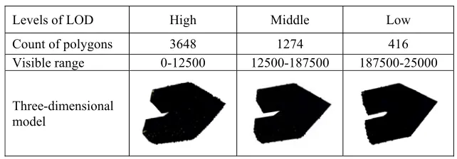
[image:6.612.145.466.345.457.2]The complexity of the model after Z-buffer algorithm processing is much more than that of the graphics system hardware, which seriously affects the real-time rendering speed of scene simulation. In order to ensure the communication speed of system, the objects are usually stored by the level of detail LOD (Level of Detail), generation of LOD model through the normal folding edge two vertex angle control. Different simplification conditions can generate different hierarchical model in detail, as shown in Table 1.
Table 1. The hierarchy chart in details of three-dimensional model.
Levels of LOD High Middle Low Count of polygons 3648 1274 416 Visible range 0-12500 12500-187500 187500-25000
Three-dimensional model
The model is composed of three different levels model in details. The rougher model is used in the far distance, and the fine model is used when the distance is near. The Analysis of Three-dimensional Modeling Results
Compare the three-dimensional modeling method in this paper with the conventional three-dimensional modeling method; the results are as shown in Figure 8.
(a) The proposed method (b) The conventional method Figure 8. The results of three-dimensional modeling.
strong sense of reality, high degree of automation, and is more convenient to be used in the virtual environment, which has broad application prospects.
Conclusions
This paper proposed a method for automatic modeling of high speed flying object. The method can use the high-resolution CCD camera to obtain the image of the high-speed flying object in the course of flight, and carry on a series of processing of the obtained images, use the image processing algorithm to extract the data information of the desired contour, the model is automatically constructed by calling Open Flight API through C++ language, and the model is optimized, not only makes the model more realistic, but also improve the speed of rendering. At the same time, it is convenient to build the object model with more complex modeling methods and write the generated model directly into Vega Prime for real-time simulation.
Acknowledgement
This research was financially supported by the National Natural Science Foundation of China (61304144, U1504619, 61503124), the Science and Technology Research Project of Henan Province (162102210073).
References
[1] Su, X. Y., Zhang, Q. C. Dynamic 3-D shape measurement method: A review [J]. Optics and Lasers in Engineering, 2010, 48(2):191-204.
[2] Wang Wei, Li Haolin. Three-dimensional reconstruction based on digital camera images [J]. Journal of University of Shanghai for Science and Technology, 2005, 27(5):429-432. In Chinese.
[3] Zhang Qing, Guo Wei. Depth images-based approach for three-dimensional reconstruction [J]. Journal of Huazhong University of Science and Technology, 2008, 36(2):88-91. In Chinese.
[4] Shu Yuan, Tan Zheng, Ding Liru. Camera self-calibration and three-dimensional reconstruction using spatial orthogonal constraints [J]. Journal of Xi’an Jiaotong University, 2005, 39(2):138-141. In Chinese.
[5] Wu Junhan, Yu Bailang, Peng Chen. A method for fast modeling of three-dimensional buildings from mobile laser scanning point clouds and remote sensing data [J]. Geomatics & Spatial Information Technology, 2016, 39(1):24-27. In Chinese.
[6] Sun Qingke, He Yuntao, Chen Ruiqiang, Jiang Yuesong. Research of three-dimensionalpoint cloud reconstruction based on structured light [J]. Application Reseaech of Computers, 2016, 33(9):2873-2877. In Chinese.