STUDY ON MINE-MAPS DYNAMIC MANAGEMENT
INFORMATION SYSTEM BASED ON WHOLE LIFECYCLE
1HUJUN HE, 2YANING ZHAO, 3XINGKE YANG, 4WENGAO ZHANG, 5CUIXIA QU
1,3,4,5School of Earth Science and Resources, Chang’an University, Xi’an, China
2
The 213th Research Institute, China Ordnance Industry, Xi’an, China
E-mail: [email protected], [email protected], [email protected], [email protected], 532986 [email protected]
ABSTRACT
According to the shortcoming of traditional artificial management mine-maps, the solutions of dynamic management digital mine-maps were proposed. Analyzing of the main tasks and characteristics in lifecycle stages of mining engineering maps, based on the idea and meaning of lifecycle, first we divided mine-maps lifecycle into seven stages, such as design drawing task assignation, design drawing, review approval, use and execution, revision, cancellation, qualitative archiving. Then put forward concept and system model of mine-maps lifecycle management, design B/S three layer network structure of mine-maps dynamic management information system on the basis of whole lifecycle, function modules of each subsystem by using CAD technology, ASP technology and database technology. Finally, we discussed the key technologies implementation of system as parametric drawing technology, database connection, online review and cooperative design etc. Field application shows that realization of whole lifecycle management automatization for mine engineering drawings improves office efficiency.
Keywords: Whole Lifecycle, Mine-map, Dynamic Management, Information System, CAD
1. INTRODUCTION
Mine-map is important technology information, which is the basis for mining engineering design, planning of mine ventilation, drainage, transportation, power supply system, as well as the guidance of production safety avoiding the accident etc. However, the management work of mine-maps in China's coal mine enterprises is still using the traditional manual management mode, a lot of problem are existed that approval cycle is difficult to control, maps management work difficulty is big etc. Especially with the increase of production technology in coal, the face is pushed in advance, the updating of mine-maps accelerates, the complexity of mine-maps management task creases. Especially computer technology and network technology are gradually applied in coal mine enterprises, the defect of traditional management mode is more apparent, can not meet the current construction requirements of high yield and efficient modern mine. Especially at present, the modern mining industry takes the computer as the foundation, and a large number of electronic drawings generated by CAD are stored in the computer. When entering into the network age,
network CAD/CAM has become the development trend of mining industry in the future. So how to take the effective management and utilization of electronic drawings up, how to makes electronic drawings information in the enterprise to transmit, share and manage rapidly and safely in a greater range, are problems waiting for solving in many enterprises[1,2].
Lifecycle is a term first appeared in the field of biology, which is used to describe evolution for creature from appeared to perish. Its basic connotation can be popularly understood as "from cradle to grave" throughout the process. With the development of society and the interdisciplinary fusion, lifecycle concept is gradually introduced into the economy, management, social organization and environment and other fields, and spawn a series of theory and methods on the basis of lifecycle[3,4].
present in China, so this paper proposes a dynamic management system model of mine-maps based on whole lifecycle. The model not only realizes mine-map documents process automation management, but flexibly makes mine-maps management processes according to the actual needs of mining engineering, to achieve seamless connection between mine-map documents lifecycle business process, and solve the existent problems in mine-map documents management system. To sum up, this paper will study and design structure and functional module structure of mine-maps dynamic management information system based on whole life cycle on the basis of the analysis on the main tasks and characteristics of mine-maps whole lifecycle stages, and the key technology of its realization are discussed.
2. MINE-MAPS DYNAMIC MANAGEMENT
INFORMATION SYSTEM BASED ON WHOLE LIFECYCLE
2.1 Mine-Maps Whole Lifecycle
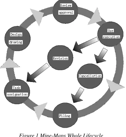
Mine safety production management involves a variety of graphics data, including mining engineering plan, comparison map up and under mine, floor contour map, reserves calculation map, mine topographic and geologic maps, ventilation system graph, dustproof system map etc. These mine-maps especially mine engineering design drawings involve a number of departments and staff from planning, design task assignation, putting into practice application finally to archives management [5]. But by analysis of its process, which can be divided into seven stages such as design drawing task assignation, design drawing, review approval, use and execution, revision, cancellation, qualitative archiving. This paper believes that the process is mine-map lifecycle, also refers to mine-map whole lifecycle, the whole process is a ring cycle, as is shown in Figure 1.
2.2 Mine-Map Lifecycle Management
Mine map lifecycle management (MLM) as a kind of management model, is designed to require the corresponding strategies and technologies through mine-maps whole life management. Mine-map lifecycle management for mining enterprise users is an information technology strategy, a concept, rather than just a product or solution. Mine-map lifecycle management implementation will break technical barriers among task orders, design and drawing persons, managers and users, make the participants through the use of mine-maps information in mine-map lifecycle achieve "in the most appropriate time, use the most appropriate
[image:2.612.320.522.278.497.2]method, to find the most appropriate resources of solution problem", reduce mine-map task orders, design and drawing persons, managers and users in time, information and material waste, to help enterprises at all stages of mine-map lifecycle gain maximum value with minimal cost. Through the implementation of mine-maps whole lifecycle management can effectively solve information sharing, interactive and collaborative problem at different lifecycle stages and various information isolated islands, advance mine enterprise information construction process, improve the production quality and efficiency, the quality of mine-maps use and the core competitiveness of enterprises.
Figure 1 Mine-Maps Whole Lifecycle
2.3 Mine-maps Dynamic Management
Information System Based On Whole Lifecycle
technology, efficient and stable, safe and reliable human-machine system on the basis of modern tools and means such as computer and communication networks etc and gathering standardization, automation, digital and informationization of mine-maps design, drawing and management for a body[6].
3. OVERALL STRUCTURE OF SYSTEM
3.1 System Structure Design
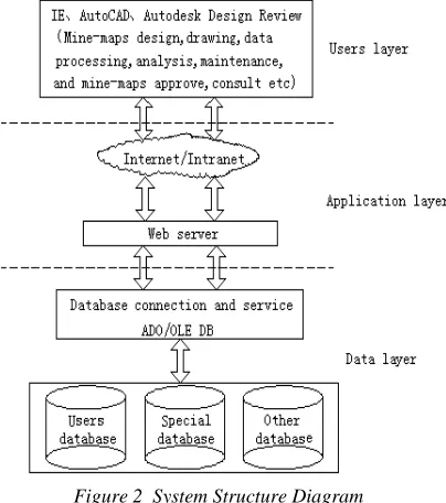
Mine-maps dynamic management information system based on whole lifecycle is achieved generally relying on enterprise broadband and high speed network. The system is carried through integration customization and secondary development by using document and program development on the basis of AutoCAD, data management platform uses Microsoft SQL Server 2000, based on the three layers structure system of Browser/Server (B/S) mode such as data layer, application layer and user layer [7-9], accesses the corresponding database by using itself data safety management and quality control system of SQL Server database and access password the database providing, to ensure the database security, system structure diagram is shown in Figure 2. The data layer is database server layer, which is the core of organization, planning and maintenance various data, mainly includes special database (for storage of DWF documents, DWG files), user database (for storing users basic information), and other databases. Application layer is application server layer, to receive the user's request, to carry out various operations, and forwards the request to the database server, and back database information to the users. Users’ layer is the client layer, which is the users’ interface with the system, is an information interactive interface. The client connects with the server through a network. The main function is to mine design personnel carry through design and drawing mine-maps, the electronic document of good design upload to mining group company server after design. Mining group management personnel or mine management carry through examination, inspection and so on. At the same time it will accept the user information request and feedback the results to show.
3.2 Design Of System Function Modules
Aiming at the lifecycle of mine-map, according to the actual needs of mine-maps in the whole lifecycle dynamic management, in the basic principle of simple and practical, data sharing, safe and stable, standards, the system is determined. The system is divided into two parts: one is mainly used
[image:3.612.319.521.391.619.2]for mine engineering and technical personnel to carry out standardization, automation design and drawing work of mine-maps, called mine digital mapping system. This system is mainly to complete all work in second phases of mine-maps whole lifecycle, mainly based on the secondary development of AutoCAD system. After mine engineering technical personnel design mine-maps, upload the saved information to mining group server; From a workflow perspective, another, aiming at mine-maps compilation and design task assignation, compilation and design, review approval by using and executive, revision, qualitative filing Another carries through transactional dynamics tracking management called mine-maps digital information management system. This system mainly completes all work in other phases of mine-maps’ whole lifecycle, mainly based on three layer system structure design of B/S. Two systems complement each other; mine digital mapping system decides whether mine-map digital information management system can correctly and effectively function. The mine-maps digital information management system is responsible for safe and effective operation of whole system.
Figure 2 System Structure Diagram
information management system embodies the advantages of mine-maps management on the basis of CAD technology, network technology and database technology, which has the features such as rapid information exchange, resource sharing convenience etc, really plays network interactive function compared with the traditional manual mine-maps management. According to the characteristics mine-maps online approval exchange and dynamic management, mine-map digital information management system is mainly made up of main interface module, system settings module, task assignation module, maps check module, qualitative archiving module, cooperative design module.
4. KEY TECHNOLOGIES OF SYSTEM
IMPLEMENT
4.1 Parametric Drawing Technology Of Mine-Maps
AutoCAD system is the man-machine interactive graphics software. Itself does not have the parameter driven drawing functions, and it can only record graphic element itself geometric information, layer and color type etc, not record topology and constraint relations with graphic elements, so in development of parametric drawing module, not only record non geometry information of graphical elements, but also consider the geometry structure, topology and constraint relation. Parametric drawing module establishment is the use of AutoLISP/Visual LISP, AutoCAD VBA language, parametric drawing module mainly uses menus, dialog boxes and database mode, achieving of parameter drawing mainly adopts interactive and data file type[10].
4.2 ASP(Active Server Pages) Technology
ASP is an application of script program Microsoft develops instead of CGI (Common Gateway Interface), it can be associated with the database and other programs, thus it is a simple, convenient programming tools[11]. ASP may easy access to the data on the database server through ADO (ActiveX Data Objects) of ActiveX component. ADO is COM component for accessing data sources Microsoft launches. It provides a programming language and an intermediate layer of uniform data access OLE DB(Object Linking and Embedding Database). Developers are allowed to access to the data code and not care how database is realized, and only care about the connection of database. Because OLE DB database connection is the most popular, provides all the connection details in string, is the fastest way, so the system uses the
OLE DE to realize ASP and SQL Server 2000 database connection.
4.3 Maps Online Review Technology
DWF(Design Web Format) is an open, compression, secure file format developed by Autodesk, it can distribute efficiently rich design data to anyone need view, review or print these data, save the time of management design and review process, is the ideal medium of realization of lifecycle management. Autodesk DWF Composer plug-in is software developed specifically for the DWF file format and engineering design data, specifically for sharing of data rich engineering graphics, maps and models, it is through the use of complete workflow, drawing browse, approval and labeling functions. Maps online approval function realization is on the basis of marking function of Autodesk DWF Composer, this system uses the VBScript script language, embeds DWF graphics in the Microsoft Internet Explorer HTML page through Autodesk DWF Composer API (Application Programming Interface), in internal controls procedures, to achieve different users review and approve maps authorized, also may carry on the function customization.
4.4 Cooperative Design Technology
interactively carry through design work. Finally, the gain design maps meet the specification requirements.
5. CONCLUSIONS
By using the whole lifecycle idea, dynamic management information system of mine-maps based on CAD technology, network technology and database technology are applied in mine-maps management of mining company. It improves the enterprises’ management level of mine-maps, realizes the line production of mine-maps management, such as mine-maps design task assignation, review, approval, use, preservation, consult and filing etc, which play an important role in mine-maps approval and management efficiency and the development of digital and informationization of mining enterprises. Thus, it plays a very good protection function for the enterprise's normal production. But in view of the capacity constraints of the author, the design and development of the system just do a preliminary exploration research, in order to enable the system to obtain the widespread application and the promotion in mines, there are still many problems need to be further studied such as mine-maps information automatic recognition and extraction, the combination of graphic data and attribute data and so on.
ACKNOWLEDGEMENTS
This work is financially supported by the special fund for basic scientific research of central colleges(CHD2011JC111). In the process of paper writing, one of us heartfelt thanks many teachers and schoolmates in school help!
REFRENCES:
[1] Hujun He, “Study on whole lifecycle dynamic management system of mine-map based on CAD”, Xi’an: Chang’an University, 2009. (In Chinese)
[2] Hujun He, Xingke Yang and Yaning Zhao, “Study of Mine-map Management Information System Based on B/S Model”, Microcomputer
Information, Vol. 25, No. 9-3, 2009, pp. 23-25.
(In Chinese)
[3] Chunjing Shang, “Study on management informationization of construction industry based on construction lifecycle”, Beijing:
Beijing Jiaotong University, 2007. (In Chinese)
[4] Xiaorong Lu, “Study on whole lifecycle management of unmanned aerial vehicle production in ASN company”, Xi’an:
Northwestern Polytechnical University, 2007.
(In Chinese)
[5] Nailiang Li, Haibing Ren, Houjun Lu and Hengting Cao, “Design on fully service period dynamic management system of mining and excavation engineering drawing and document”, Coal Science and Technology, Vol. 37, No. 1, 2009, pp. 14-17. (In Chinese)
[6] Yihui Li and Zhenglong Yan, “Foundation of mine-maps management information system based on GIS”, Proceedings of symposium on coal resource high efficiency green mining and
digital mine, China Coal Institute, 2005, pp.
148-150. (In Chinese)
[7] Xiujuan Sun and Minfeng Yang, “Design and impalemement of job management system based on web”, Journal of Beijing Polytechnic
College, Vol. 8, No. 2, 2009, pp. 30-32. (In
Chinese)
[8] Liangdong Zhang, “Study on integrated engineering drawings management system based on WEB”, Chengdu: Sichuan University, 2005. (In Chinese)
[9] Xiaojun Wang, “Research and Implementation on management system of engineering drawing based on Web”, Liaoning: Dalian University of
Technology, 2005. (In Chinese)
[10] Tao Zhang and Yunjia Wang, “Application of AutoCAD secondary development Based on VBA in mine-maps”, Industry and Mine
Automation, No. 5, 2008, pp. 85-87. (In
Chinese)
[11] Yajuan Pang, Mingli Sun and Jidi Lv, “Self-study manual of ASP network programming”,
Beijing: People Posts & Telecom Press, 2008.