University of South Carolina
Scholar Commons
Theses and Dissertations
2016
Rediscovering Camden: The Preservation of a
Revolutionary War Battlefield
Gary Sellick
University of South Carolina
Follow this and additional works at:https://scholarcommons.sc.edu/etd
Part of thePublic History Commons
This Open Access Thesis is brought to you by Scholar Commons. It has been accepted for inclusion in Theses and Dissertations by an authorized administrator of Scholar Commons. For more information, please [email protected].
Recommended Citation
Rediscovering Camden: The Preservation of a Revolutionary War Battlefield
by
Gary Sellick
Bachelor of Arts
University of Kent, 2010
Submitted in Partial Fulfillment of the Requirements
For the Degree of Master of Arts in
Public History
College of Arts and Sciences
University of South Carolina
2016
Accepted by:
Allison Marsh, Director of Thesis
Steven D. Smith, Reader
ii
iii
Acknowledgments
This thesis has been eighteen months in the making and I would be foolish not to
acknowledge the many people who have helped guide me throughout its creation. Firstly,
I must thank Dr. Allison Marsh, Director of the Public History program at the University of
South Carolina; before I met her, I did not know what the term “Public History” meant.
She has been a touchstone for me throughout this project. In the same way, Dr. Steve
Smith of SCIAA (South Carolina Institute of Archaeology and Anthropology) and his
colleague James Legg provided helpful guidance throughout the various drafts of this
project, challenging me creatively at every step. Their close attention to detail, and
openness in sharing their stories with me, were crucial to the outcome of this project.
Needless to say the process from interviews to writing to producing a finished
draft indebted me to a great many individuals who guided me both spiritually and
academically. I would therefore like to thank; John Allison, Kyle Bjornson, Justin Davis,
Holly Genovese, Bob Karachuk, Andrew Kettler, Casey Lee, Daniel Reese, Ellen Robertson,
Amanda Schlegel, Dr. Constance Schulz, Mary Sherrer, Cane West, and all of my
colleagues in the Public History department at the University of South Carolina. Your
helpful insights in the grad lounge, your babysitting expertise, or your calming influence
helped to make what could have been a stressful journey a tremendously exciting one.
Perhaps more than anyone else, my wonderful wife Alyssa bore the brunt of the
iv
kept me on the straight and narrow, reminding me daily the strength that derives from
love and family. Also, to my little daughter Darcy (who was much littler when I started
this project), thank you so much for bringing me so much joy throughout the writing of
this thesis. I think you will agree that your dad did “O-tay.” Thank you also to the extended
Seymon family, and my own Sellick clan across the ocean for all the love and support, I
could not have done it without you.
This entire project started with a trip to Camden battlefield I undertook in January
2014. It was a cold, wintry day but even in the grim weather, I felt the importance of the
site; a site that only exists today due to the dedication of a relatively small number of
people. I am indebted to Charles Baxley, Joanna Craig, James Legg, and George Fields for
kindly finding the time to answer my many inquiries about a project so dear to their hearts.
This thesis is also dedicated to the thousands of other individuals who played a role in the
preservation of Camden Battlefield, throughout its history. For your many sacrifices, the
v
Abstract
The Battle of Camden was the largest pitched battle fought in South Carolina
during the Revolutionary War, yet until the late twentieth century the battlefield itself
was largely forgotten. For over two hundred years, the ground on which so many men
fought and died was used for timber, only visited by relic hunters wishing to collect a piece
of its relatively hidden history. Then, beginning in 1996, local organizations around South
Carolina began to recognize the value of the site. Using federal funds, but without the
close assistance of national bodies, this group of local preservationists bought the site,
saving Camden battlefield from possible destruction, and reinterpretation the history of
the site using modern archaeological evidence. Looking at the archaeology, politics,
organizations and people that were involved in the process, this thesis shows the
successes and limitations of the grassroots preservation movement that rediscovered
vi
Table of Contents
Acknowledgements
. . .
.
iiiAbstract . . . v
List of Figures . . . vii
Introduction . . . 1
The Battle of Camden . . . .. 5
Chapter One: The Re-Creation of a Battlefield (1900-1995) . . . 11
The DAR and the Memory of Baron De Kalb . . . 12
Chapter Two: The Second Phase of Preservation (1996-2015) . . . 18
Finding Camden: The Search for a Historic Battlefield . . . 21
Unearthing a Battle: Archaeology at Camden Battlefield . . . 27
Reinterpreting the Interpretation at Camden Battlefield . . . 39
The Political Battle for Camden Battlefield . . . 47
Conclusion: The Future of Camden Battlefield . . . 53
vii
List of Figures
Figure 1.1) Photograph of De Kalb monument on Camden Battlefield. . . 17
Figure 2.1) Map of easement boundary, DAR property boundary and National Historic Landmark Boundary at Camden Battlefield . . . .. . . . 29 Figure 2.2) GPS topographical map recording location of artefacts found by
SCIAA at Camden Battlefield . . . 36 Figure 2.3) Topographical map indicating SCIAA dig locations at Camden
Battlefield . . . 38 Figure 2.4) Photograph of Jim Legg during SCIAA fieldwork at Camden
Battlefield . . . 39 Figure 2.5) Drafts of wayside markers created for the Palmetto Conservation
Foundation . . . . . . 42 Figure 2.6) Tourist map of the Camden battlefield created by the Palmetto
1
Introduction
The Battle of Camden was fought by accident. On a moonlit night in the rolling
sandhills of South Carolina’s midlands, two tired armies slogged through the oppressive
humidity of a southern summer. Both armies, a large American force and a smaller British
one had been marching for three hours. By a quirk of fate, they both happened to be on
the same road. At 2am in the morning of August 16, 1780, the two armies blundered into
each other in a patch of pine forest with absolutely no strategic value. The resulting battle
would be the worst American defeat in a field battle in the southern campaign of the
Revolutionary War.
The Revolutionary War battlefields in South Carolina are among the best
preserved in the nation.1 The National Park Service operates four Revolutionary War sites
in South Carolina; Cowpens, Kings Mountain, Fort Moultrie and Ninety Six. Of these, three
were the site of Patriot victories in the Revolutionary War. Despite the sheer scale of the
Battle of Camden, which featured more soldiers than the battles of Kings Mountain and
Cowpens combined, the site of the action was largely neglected by a nation happier to
reflect a whiggish narrative of the war than focus on a costly setback which cost the lives
1 For the purpose of this paper, preservation in this context will include both the act of preserving the site
2
of hundreds of Americans.2 This victory-laden view of American history, as portrayed at
South Carolina’s Revolutionary War sites, are evidence of a “Heritage Syndrome”
identified by Michael Kammen. He suggests this approach to US history is “an impulse to
remember what is attractive and flattering and to ignore all the rest.”3 From a US
perspective there is nothing attractive about the Battle of Camden. Nonetheless, despite
a national antipathy towards the battlefield, grassroots organizations in Camden and
Kershaw County, in which the town is situated, have long tried to preserve the battlefield.
Beginning at the turn of the 20th century, there has been a concerted movement to
protect the battlefield and interpret the action that took place upon it more than two
centuries ago. These efforts have experienced the ebbs and flows that effect most
grassroots preservation movements, but the progress made through these efforts have
ensured that the land on which the battle was fought has largely been protected. The
battlefield is therefore a very useful lens through which to view and analyse grassroots
attempts to protect and interpret such a property.
This study asks the question of why Camden was not preserved like many of the
other battlefields of the Revolutionary War in South Carolina. It finds that the greatest
obstacle to the earliest preservation movement at Camden was the fact that the
battlefield was the site of an American defeat, with few wanting to take ownership of
2 The participant numbers (2100 British, 3700 American) for the Battle of Camden, as well as those of
Cowpens and Kings Mountain are widely available. So too are the casualty figures of all of these
engagements. For this study, the source consulted was: John Buchanan, The Road to Guilford Courthouse: The American Revolution in the Carolinas (New York: Wiley, 1997).
3 Michael Kammen, Mystic Chords of Memory: The Transformation of Tradition in American Culture (New
3
such a site of national embarrassment. As a secondary question, this study asks how
modern interpretive techniques were applied to the battlefield preservation effort at
Camden, and why these efforts were conducted in the first place.
The protection of Revolutionary War battlefields was considerably different than
that of their Civil War counterparts. The “golden age” of battlefield preservation,
occurring in the 1890s, refers to the preservation of Civil War sites, such as Gettysburg
and Vicksburg.4 This “golden era” left behind most of the Revolutionary War battlefields,
in fact the first five National Battlefield Parks were all Civil War sites. The main reason for
this was the presence of Civil War veterans who demanded that endangered battlefields
on which they had fought and bled be preserved as sites of memory and, later, as sites of
national reconciliation.5 Of course, as the first National Battlefields were being created,
there were no veterans of the Revolutionary War to make the case for the preservation
of sites from that conflict. Indeed, nearly every Revolutionary War battlefield that is
preserved was the product of grassroots activism on a local level. The Revolutionary War
battlefields that then received federal recognition were grandfathered into the National
Park system at the same time as a second tier of Civil War battlefield sites. Occurring in
the opulent pre-Depression era years when patriotic nationalism was high in the US, the
golden age of Revolutionary War preservation was the 1920’s.6
4 Timothy B. Smith, The Golden Age of Battlefield Preservation: The Decade of the 1890s and the
Establishment of America’s First Five Military Parks (Knoxville: University of Tennessee Press, 2008), 1.
5Jennifer M. Murray, On a Great Battlefield: The Making Management and Memory of Gettysburg
National Military Park, 1933-2013 (Knoxville: University of Tennessee Press, 2014), 13.
4
It was during this period of Revolutionary War preservation that Camden
battlefield garnered local attention for the first time, but it was an oddity. The
Revolutionary War sites to become National Parks in 1902 were Valley Forge and
Yorktown, both national symbols of triumph over adversity during the war.7 Camden
never fit easily into the national progress narrative that the National Park Service
vigorously supported in the early twentieth century. The federal government for the next
seventy years largely neglected it.
While many scholars have looked at the preservation of Civil War battlefields in
the US, there is a dearth of scholarship on the subject of Revolutionary War battlefield
preservation. The battlefield at Camden has largely been ignored by scholars, with no
work on the preservation of the site looking beyond 1980. As an extension of R. Bryan
Whitfield’s work, The Preservation of Camden Battlefield (1980), the first study to look at preservation at the site, this study brings the scholarship on the preservation of Camden
battlefield up to date. 8 It also inserts Camden into a larger commemorative field that,
although often neglecting Revolutionary War battlefield preservation, certainly contains
many works on the memory of the conflict in the American consciousness.
7 Ibid, 44.
8
5
The Battle of Camden
In the early morning hours of August 16 1780, the Patriot American army of
Horatio Gates blundered into the advancing British army of Charles Cornwallis on an old
wagon road, some six miles north of the frontier town of Camden, South Carolina.9 The
fortunes of war played out that at exactly the time that Gates was striking south to move
his forces closer to Camden, Cornwallis was himself setting out in order to launch a
surprise attack on Gate’s camp at Rugeley’s Mill, about twelve miles north of Camden. It
was at about two o’clock in the morning of August 16 that the two armies marched into
one another in the pine forest north of the town. After a short skirmish, both sides
withdrew into the darkness. Neither general wished to fight at night, and so both
commanders placed their armies into lines of battle and waited until the morning to
attack.
Camden, a small outpost town on the South Carolina frontier had been thrust into
the Revolutionary War by actions that occurred almost 100 miles away, on the coast, two
months earlier. On May 12 1780, Charlestown, the greatest city in the Southern colonies
of British North America fell, with the triumphant British entering the city to gain the
9
The time of the march south to Camden, as well as Cornwallis’s march north is found in numerous sources. For more information on the movements of both armies see; Horatio Gates to Samuel Huntington, August 20th 1780; Otho Williams “A Narrative of the Campaign of 1780.” In Sketches of the
Life and Correspondence of Nathaniel Greene, William Johnson, Ed (Charleston, SC: A.E Miller, 1822), 485-510. Banastre Tarleton, Campaigns A History of the Campaigns of 1780 and 1781 in the Southern
6
spoils of a great victory. It had taken less than two months for the British General Henry
Clinton to force the Patriot commander, General Benjamin Lincoln, and the entire Patriot
Southern Army to capitulate. The surrender was a gut-blow for the entire American
independence movement. Indeed, the surrender of Lincoln’s army of 5,500 men would
be the greatest capitulation of American forces in the entire war.10
Cornwallis, Clinton’s successor in South Carolina, quickly moved to establish a line
of forts throughout the South Carolina frontier to quell the rebellion in the backcountry –
Camden became one of these British bastions. In the meantime, the Continental Congress
hastily assembled an army in Virginia under the command of Horatio Gates and sent it
south to stop Cornwallis’s conquest of South Carolina.11 Gates marched his army through
the heat of summer; lacking food and equipment, including tents, his men were
exhausted by the time that they reached Rugeley’s Mill, near Camden, in mid-August.
Giving them only a day’s rest, and believing the British forces to be much smaller than
they really were, Gates set off on the night of August 15 to force an engagement with the
British, setting in motion the events which would lead to his army’s demise.
Dawn on August 16 found the two armies spread out on either side of the wagon
road in a pine forest. The men of the patriot Virginia militia made up the extreme left
10 In fact there would not be as big a surrender of US troops again until 1862, when ‘Stonewall’ Jackson
captured some 10,000 at Harpers Ferry during the Antietam campaign.
11 Horatio Gates to Thomas Jefferson, August 3rd 1780. John Robertson, ed. “Documentary History of the
Battle of Camden, 16th August 1780.” Battleofcamden.org. Web. Accessed: 03/27/2014. Gates was
7
flank of Gates’ army. The Virginians were in no fit state to fight a battle as they stood
awaiting the first rays of morning light. Not only were they fatigued from the night march
and their previous exhaustions but now, a new problem, an issue caused directly by the
inept actions of the commanders, further hindered their physical strength. It was the
policy of armies in the eighteenth century to be given alcoholic sprits, normally rum, prior
to battle. Due to ongoing supply problems in Gates’ army, which had been present in the
American camp throughout the campaign, there was no rum available for the men to
consume on the evening of August 15. Fearful of the effects on morale of sending his
troops into battle without their liquor ration, Gates made a disastrous decision of ordering
molasses to be substituted for rum. The inappropriate use of molasses, in addition to a
meal of poor quality meat and green corn, meant that the Patriot troops about to fight
were weakened by an avoidable ailment, diarrhoea. This new affliction was noticed by
Otho Williams who was serving as Gates’s adjutant general, “a desert of molasses, mixed
with mush, or dumplings, operated so cathartically, as to disorder many of the men, who
were breaking ranks all night.”12 Adding to the fatigue the men from Virginia were already
12
Otho Williams in: Johnson, Sketches of Nathaniel Greene. 494. The evidence of the poor meal and molasses can be found in many primary account of the battle, as can its disastrous effects on the troops. The fact that Continental troops as well as the militia complained of the meal proves that it was not only reserved for the Virginians. See: Sgt. William Seymour (Delaware Continentals); in his diary. Quoted in; Jim Piecuch, Ed., The Battle of Camden: A Documentary History (Charleston, SC: The History Press, 2006), 71; William Gipson (NC Militia); in his pension record; Quoted in: John C. Dann, ed., The Revolution
8
suffering, the intestinal distress caused by the previous night’s meal meant that on the
morning of the battle the men were on the verge of total physical and mental collapse.13
As the sun rose on a hot and humid morning that would soon become a sweltering
August day, the entire British line advanced towards the Patriots. The artillery of both
sides began to sound and soon thick smoke, trapped by the pines that stood in their own
ranks across the battlefield, obscured the lines. Hoping to meet the British while they
advanced, Gates ordered the untried Virginia militia to advance on the experienced
British regulars opposing them. The effects of the attack were predictable. As the militia
halted to fire they observed the British regulars, bayonets fixed, steadily advancing
towards them. From out of the smoke, the red coats of the British emerged, their shouts
and cries of “Huzzah!” chilling the hearts of the Virginians, many of whom had never seen
battle before. Before a shot was fired, the Virginians turned and fled the field. They
suffered only three casualties during the entire action. The North Carolinian militia
aligned next to the Virginians were also suffering from fatigue and seeing their comrades’
retreat was too much for their resolve. As the British advance continued, the North
Carolinians broke before them.14 The result was the collapse of the entire American left
13
Jim Piecuch’s 2006 edited volume The Battle of Camden, is the first single volume to collect nearly every useful primary account of the battle. It is from these primary accounts that I have based my narrative version of events. As well as this, the first scholarly account of the battle by Lt. Col. H. L. Landers of the Army War College has also proved useful. See; H. L . Landers, The Battle of Camden South Carolina August 16, 1780 (Washington DC: US Government Printing Office, 1929). Finally, an excellent, and recent, summation of the battle, taken from both Piecuch’s sources, Lander’s narrative, and modern
archaeological evidence is found in; Steven D. Smith, James B. Legg, & Tamara S. Wilson, The Archaeology of Camden Battlefield: History, Private Collections, and Field Investigations (Columbia, SC: South Carolina Institute of Archaeology and Anthropology, 2009).
14 Buchanan, Road to Guilford Courthouse, 166. The quick flight of the regiment can be seen in the fact
9
flank. While Dixon’s regiment of North Carolinians, a mixture of militia and continentals,
withstood the initial British advance, they also fled after firing three volleys at the
British.15 Gates himself fled the field at this stage, retreating as far as Charlotte, North
Carolina before stopping.
On the other side of the road, on the American right flank, Baron Johann De Kalb’s
Continental troops fought well despite the failure of the rest of Gate’s army. In addition,
Gates’ reserve force of Continental troops under General William Smallwood tried to plug
the huge gap left by the retreating militia but soon found themselves pushed back until
they were at a right angle to De Kalb’s, the American line forming an L-shape and assailed
unrelentingly by the British.16 Eventually the weight of British numbers overwhelmed
Smallwood and De Kalb, who was himself mortally wounded during the battle. The
remaining Continentals fought on bravely before retreating themselves. The battle had
lasted less than one hour. With their victory, the British were left in control of the
battlefield, and South Carolina. Four days after the battle, General Stevens of the Virginia
militia wrote to Governor Thomas Jefferson “a more compleat Defeat could not possibly
have taken place…in short picture it as bad as you possibly can and it will not be as bad as
it really is.”17
Both units suffered from fatigue at Camden and yet it was the Virginians that broke first. The most likely reason for this is because they were the first unit engaged on the Patriot side although the different effects of fatigue on individuals may also have played a role in this. See also, Smith et al., The Archaelogy of the Camden Battlefield, 23.
15Smith et al., The Archaelogy of the Camden Battlefield, 23.
16 Ibid, 25.
10
When the battle ended, both sides vacated the pine forest and the rest of the war
saw that barren section of land totally forgotten. Whilst the Battle of Hobkirk’s Hill would
rage around Camden in 1781, the pine forest survived the encounter in serenity. After the
war, the area was not heavily planted as the cotton boom hit South Carolina, with many
of the battle scarred trees surviving well into the next century.18 Meanwhile, the local
population, who had never forgotten the carnage of that summer’s day in 1780, became
relic hunters.19 Yet while treasure seekers sought a piece of history, the land on which the
battle raged was turned first into privately owned farmland and then corporately owned
land for timber companies. By the turn of the twentieth century, it had been over a
century since the fighting of the Battle of Camden but the struggle to save the battlefield
was only just beginning.
18 Whitfield, The Preservation of Camden Battlefield, 56.
11
Chapter One: The Re-Creation of a Battlefield: 1900-1995
The battlefield at Camden is very different today than it was when two great
armies fought there in 1780. The long-leaf pine trees, their tall branches creating a canopy
of firs that had both shielded the exhausted soldiers from the sun, but also enclosed the
smoke of the day’s battle, have long since been removed. In 1995, a visitor to the site
would find rows of planted short-leaf pine, some small enough to place in your house and
decorate at Christmas time while others stretched skyward, never able to attain the
height of their long-leaf brethren. On the ground, a dense underbrush of nettles, briars,
and weeds, made the battlefield almost impassable. The wagon road, which had been
vital in the peopling of this part of South Carolina, had long since been swallowed up by
nature, with only a few isolated stretches still discernible to those intrepid enough to be
looking. A new road, from the age of the automobile, paralleled the old one, splitting the
battlefield in two.
The forest that had reclaimed the battlefield was not that much different from
many of the forests that had grown out of the sandy soil of the South Carolina midlands.
Timber companies, after exhausting the old growth long-leaf pine, had planted the land
with faster growing species to turn a profit from a soil that was unforgiving to all but the
most maverick farmer. Just off the main road, which used to be the major highway
12
had no earthly business being in this part of South Carolina could be found. Those
travellers who observed it, or the iron wayside marker nearby, would know that they were
on a very special piece of ground. However, a driver who was changing the station on his
radio or simply looking the other way for a split moment would never have realised that
the largest Revolutionary War battle in South Carolina had been fought in the woodland
through which they drove.
Any travellers that wished to stretch their legs could walk through the small
cleared area surrounding the granite block. Unlike the rest of the forest that had engulfed
the battlefield, a lumber company did not own this little piece of tranquillity. Instead, it
was owned by the Daughters of the American Revolution (DAR), an organization that
cared more for the heritage of the Camden battlefield than simply the price of timber.
The granite block was the first actual attempt to interpret Camden battlefield, and before
1995 it was the only one.
The DAR and the memory of Baron De Kalb
Baron Johann De Kalb was the quintessential American hero of the Battle of
Camden, even though he was actually German. Despite this, De Kalb represented the
Revolutionary Atlantic World in the Eighteenth century and the kind of volunteerism that
American Patriots prized so highly. A Bavarian by birth, De Kalb earned his title of Baron
after years of loyal service in the German army. In 1777, he sailed with the Marquis de
LaFayette to America in order to ensure the liberty of the American colonies. At Camden,
13
commander Horatio Gates ignominiously fled the field. The admiring British carried De
Kalb to Camden, where he succumbed to his wounds. He was laid to rest under the sandy
soil of South Carolina, a foreign nation he had given his last breath to defend.
With such a heroic backstory, it was no surprise that De Kalb became the symbolic
hero of the American defeat at Camden. For a people trying to salvage something from
the Camden debacle, De Kalb seemed the right figure around which to build their
memorialization of the battle. The first monument to him was constructed in 1825, a large
obelisk under which he was reinterred.20 On a sunny March day in that year, a large group
of dignitaries were on hand, as De Kalb’s body was carried over the dirt roads of the town
to a site more befitting an American hero. His elderly friend, the Marquis De LaFayette,
who had come to the Americas to fight with his old friend back in 1777, read his eulogy.21
With De Kalb buried in the center of Camden, the heroic status of the fallen hero was
appealing to the DAR who decided to resurrect his memory almost a century after his
original memorial was dedicated.
While his gravesite was being adequately upgraded, the site of his demise was a
patchwork of farmland and woods that was largely neglected by all except those who
lived nearby. To these farmers, the odd musket ball or bone dug up when the spring
ploughing was conducted provided the only tangible connection between them and the
history of the site. In the early twentieth century, a new organization named the
20 Anon, The Southern Chronicle, and Camden Literary and Political Register, March 19, 1825.
21 Whitfield discusses the De Kalb monument in great detail in his thesis on Camden, and it is on his
14
Daughters of the American Revolution created a chapter in Camden. These women
decided that the neglect of the battlefield was not befitting the honor of the men who
died there, and that some form of memorialization was necessary.
The DAR decided to erect a monument to De Kalb on the spot where legend
suggested that he had fallen during the Battle of Camden. The monument was to serve
two major purposes; to glorify the site and to provide a tangible link to the town itself. As
the number of tourists visiting Camden increased, the De Kalb story could be traced from
the site of his wounding on the battlefield to the eventual place of his burial in the town
itself. As well as this, the monument was built with private funds and so the DAR needed
to present an engaging narrative to donors, and the De Kalb story was one that many
would be familiar with.22 After receiving permission from the owner of the land, the DAR
set to creating the monument. The monument was dedicated on May 28, 1909, and is still
the spiritual heart of the battlefield today. The recalibration of the battlefield to a site of
heroic defeat was successful, the Camden Chronicle praised the DAR monument: “All praise the gallant women of the DAR! The monument will not only mark the spot where
fell the gallant De Kalb, but will also bear testimony to the untiring efforts and loyal
patriotism of these women.”23
While the building of the monument was a positive first step towards interpreting
the battlefield, the DAR’s reinterpretation was not without problems. The location at
22 The DAR actually raised the funds for the monument by having a fund raising tea party in Camden in
January 1909. See; Anon, The Camden Chronicle, January 15, 1909.
15
which De Kalb fell has been highly disputed over the years. The DAR interpretation is
based on oral accounts that had suggested De Kalb was seen sitting against a tree near
the location of the present day monument after his wounding.24 The problem is that most
of the Revolutionary era trees had already been lost due to turpentine extraction on the
battlefield, and so no such tree existed on which the DAR could base their interpretation.
This problem was compounded by the text the organization decided to place on the
monument that insisted that De Kalb was “mortally wounded on this spot.”25
Modern scholars of the battle, and those that played a prominent role in the
second phase of its interpretation, are dubious as to whether the monument was sited
correctly. Steve Smith, one of the chief archaeologists in the second phase of the
interpretation, has done extensive work on the land around the monument. While not
specifically looking for the site of De Kalb’s wounding, Smith did not find any evidence of
that specific event occurring there.26 The archaeology of the site does show it to be at
the heart of the American battle line, however, with many battle artefacts from
Smallwood’s stand found around the monument. More central to Smith’s dubiousness is
the fact that De Kalb’s troops fought several hundred yards from the position of the
modern monument, making the American right flank a more likely spot for his wounding.
24 A Diagram showing the location of the pine against which De Kalb was reportedly found, was printed in
an early 20th century account of the battle and seems to be the one on which the DAR based the
placement of their monument. See; Thomas J. Kirkland & Robert M. Kennedy, Historic Camden, Part One: Colonial and Revolutionary (Columbia, SC: The State Co., 1905), 160.
25 Whitfield, The Preservation of Camden Battlefield, 60.
26 Smith, Steve. Interview with Gary Sellick. 09/11/2015. See also; Smith et al., The Archaeology of
16
Simply, the monument was placed without any historical evidence being taken into
account. Indeed, rather than historical accuracy, Charles Baxley, a leader in the current
preservation efforts, suggested a more practical reason for the placement of the
monument: “I know when the monument was out there, there was probably not much
readily available heavy-moving equipment.”27 As well as this, the position of the
monument near to the main highway between Charlotte and Camden also made it
accessible to the increasing number of tourists that they expected would visit the site (see
fig 1.1). Whether the placement of the monument was historically correct or not is largely
irrelevant, however. The DAR had wanted to memorialize the battlefield and with the
placement of the De Kalb monument at the site, they became the first group to do so.28
27 Baxley, Charles. Interview with Gary Sellick. 08/27/2015. Whilst Baxley’s simplistic explanation does
make a good deal of sense, it is important to remember that folklore sited the pine De Kalb was found against next to the road, as indicated in Kirkland and Kennedy’s book, only four years before the monument was laid, see; Kirkland and Kennedy, Historic Camden, 160.
17
18
Chapter Two: The Second Phase of preservation (1996-2015)
In the years after the dedication of the monument, the DAR was able to secure an
option to purchase 425 acres of battlefield, but unfortunately the Great Depression took
hold before the group could act upon it. In 1942, however, the group were able to secure
a 6-acre tract of land surrounding the granite memorial that became the first part of the
battlefield to be preserved.29 The area, known to the group as De Kalb Park, was a small
lot that the women cleared of the large, shadowy pines and underbrush that plagued the
rest of the battlefield. Further to this, the group also managed to have the South Carolina
Department of Transportation erect a roadside marker by the entrance to the park in
1954, giving the first interpretation of any detail at the site.30 While original plans for the
park included an interpretive kiosk and picnic tables, a lack of interest in commemorating
the battle by higher authorities meant that none of these ideas came to fruition. Instead,
the De Kalb Park site remained a relatively pristine but badly interpreted area of the core
battlefield area at Camden.
At the same time that the local movement to preserve the battlefield, led by the
DAR, was in the midst of its ebb and flow, the Federal government also began to
29
Whitfield, The Preservation of Camden Battlefield, 66.
19
tentatively focus on Camden battlefield. The national movement began with the
publication of Lt. Col. H.L Landers report of the battle in 1929, which had been
commissioned by the Army War College and became the first scholarly account of the
Camden debacle.31 After the Second World War, the site was looked upon with renewed
interest and, supported by local efforts, the battlefield was granted National Historic
Landmark Status in 1961.32 In the 1970s, the first attempts to turn the site into a National
Park failed and the battlefield remained in private hands as the twentieth century came
to a close.
By the year 2000, two large timber corporations, Bowater Inc. and Duke Energy,
owned the tangle of trees and underbrush that dominated the majority of the battlefield.
For visitors who stopped at De Kalb Park, which was not in itself an easy feat, the felling
of trees and the rumbling of machinery often shattered the calm of the site. This left the
DAR land as an island of preserved battlefield in a sea of industrial activity.33 However, a
much greater problem faced the battlefield preservation movement. While there had
been a steady supply of battle narratives arising out of the Revolution, which led in part
to the placing of the De Kalb monument, no one had actually documented where the
31
Landers, The Battle of Camden, iii.
32Whitfield, The Preservation of Camden Battlefield, 71; Smith et al., The Archaeology of Camden
Battlefield, 2.
33Everyone interviewed by the author recollected the ownership status of the battlefield. However, the
20
actual battle was fought. As a result, the exact location of the battlefield itself remained
a mystery to most of the people involved in the project in 2000.34
The battlefield was not a mystery to everyone, however. Even as bulldozers
levelled eighty-foot pines on one side of the battlefield, amateur relic hunters could be
found scurrying amongst the newly cleared areas looking for Revolutionary War artefacts.
Among rows of twisted roots and briars, these amateurs trespassed with their metal
detectors trying to discover any object that they could link to the battle. Relic hunting at
Camden was not a new idea in the twentieth century. Ever since the battle took place in
1780, souvenir collectors and relic hunters had been combing the battlefield for artefacts.
In 1849, less than a century after the battle, historian Benson J. Lossing visited the
battlefield and noted, “I was informed that many musket balls have been cut out of the
trees; and I saw quite a number of trunks which had been recently hewn with axes for the
purpose.”35 While the instrumentation that accompanied relic hunting had changed
considerably in the years since Lossing’s observation in the nineteenth century, the
numbers of treasure seekers that descended on Camden battlefield annually had not. This
group would be a vital source for researchers to utilise in the new phase of preservation
at the site.
34
While the Camden Battlefield had been granted the status of National Historic Landmark in 1961, the boundaries for the landmark were based on speculation and thus were massively larger than the historical record of the battlefield actually was (See Fig. 2). Within this site, the actual narrative interpretation of the battle itself was non-existent.
35
21
There are many similarities between the early preservation efforts at Camden
battlefield and the ones of the twenty-first century. Both relied heavily on the sense of
“place”, a central need in the battlefield preservation movement since the late 19th
century. Both were also grassroots movements, based around the tireless work of
individuals from the Kershaw County area who fought against the odds to preserve a
battlefield for a gain more spiritual than financial. Again, the larger national preservation
organizations would fill the role of the villains of this piece, seemingly ignoring the work
done on the ground and doing little to enhance the work of the local community. However,
there is one key difference between the early and later preservation narratives; the role
of national funding bodies, groups that the DAR could not access in their earlier
movements. These national bodies would eventually give much in order to allow the
battlefield preservation movement at Camden to flourish until the impact of the global
recession ended this golden age of preservation at the battlefield.
Finding Camden: The Search For a Historic Battlefield
George Fields is a striking man. While age has softened his features, his alert eyes
(and even more alert mind) reveal him as more than just a retiree on the backside of
eighty years. Fields has been a military man; he retired as a general in the Chaplain corps
before he took an interest in the preservation of battlefields in South Carolina. In 2000,
he was a younger man, in his sixties and recently retired. It was the sheer scale of the
22
because it was so large...The people in Camden, as you know, had tried (to preserve the
site) but they couldn’t pull it off.”36 Fields was employed by the Palmetto Conservation
Foundation (PCF), a South Carolina non-profit organization that specialized primarily in
the creation of walking trails in the state.
Fields had visited the battlefield, or at least the De Kalb park area, before and so
knew the maze of trees and stumps to be more than simply a logging patch. He had spent
many evenings reading the accounts of the battle and so was well-versed in Battle of
Camden lore when he first got involved in the preservation project. PCF had no real
interest in battlefield preservation but Fields was very persuasive and promised to lead
the effort if PCF would support him, which they readily agreed to. Fields quickly learned
that another state organization, the Katawba Valley Land Trust (KVLT), had been working
with Bowater Inc., who owned a large section of the battlefield, in order to secure a
conservation easement on the site to prevent any future development on the
battlefield.37
36
Fields, George. Interview with Gary Sellick. 10/19/2015.
37The Katawba Valley Land Trust had first approached Bowater about the easement in the mid-1990s but
negotiations with the paper merchant were excruciatingly slow for all involved. The KVLT is a non-profit organization based out of Lancaster, South Carolina whose purpose is to negotiate conservation
easements on areas of natural or historic interest in the state. Camden was their first battlefield project. The easement was finally completed in 2000. It covered 310 acres of battlefield site for the period of 50 years but required the KVLT to complete a long-term strategic plan for the land. This information was explained patiently to me by: Baxley, Charles. Interview with Gary Sellick. Personal interview. Camden, South Carolina, 8/27/2015. See also; See also; James B. Legg, Steven D. Smith, & Tamara S. Wilson,
23
The KVLT was headed by Lindsey Pettus, a man who believed deeply in the
preservation of Camden battlefield for future generations. One of the main functions of
the organization was to negotiate preservation easements over land of public interest,
and this is what Pettus set out to do with the Camden battlefield. The only problem was
that no one at the KVLT knew what parts of the pine forest at Camden needed to be
protected. In order to solve this puzzle, Lindsey Pettus approached an archaeologist, Jim
Legg, in 1996. Legg, who had written his MA thesis on the Battle of Camden and had thus
become familiar with the battlefield, suggested an area of 316 acres within the existing
National Landmark Boundary to be the first parts to be preserved.38 Further to this, whilst
the negotiations for the easement between the KVLT and Bowater Timber were ongoing,
Legg received permission in 1998 to do some sample metal detecting on the west side of
the battlefield, the results of which confirmed his ideas regarding the initial easement
area. The easement would protect the land around the De Kalb monument and a sizeable
chunk of the area on which so many men suffered and died over two hundred years
prior.39 The easement process was completed in 2000, just as George Fields and PCF
began their interest in the project. Thanks to Pettus, Legg and the KVLT, a part of the
battlefield was safe, at least for now, but it was then up to Fields to push the project
forward.
Independent of Fields, PCF or the KVLT, the people of Camden were also beginning
to awaken to the fact that they had a prime piece of battlefield real estate in their own
38
Legg, “The Camden Battlefield, 1996-2010”, 8.
24
backyard. The local Camden group actually became interested in the site long before
Fields did. Two local lawyers, Charles Baxley and John DeLoach, both of whom had a
personal interest in Revolutionary War history, led them. Baxley, a man who is completely
self-taught in Revolutionary War military history and yet knows more than most scholars
on the subject, was quickly told that his assistance on the preservation movement would
be more of a hindrance than a help. He explained, “Johnny put on a meeting of about half
a dozen people at his house one day…I was advised to leave it (the preservation) alone
and let the experts take care of it.”40 Thus, while there was local interest, it was deemed
better by the locals to let the larger organizations deal with the battlefield, and for the
community groups to play a smaller, supporting role.
The discontinuity between local and larger groups has been one that has plagued
the battlefield preservation movement at Camden since its inception. Many small ranch
homes dot the road that lead to the battlefield and many of these landowners own land
on the battlefield itself. These private landholders had always been concerned that the
creation of a battlefield park, or even the preservation of the battlefield in any form, was
a threat to their own property rights.41 This still is particularly concerning considering the
number of rural properties that adjoin the existing battlefield site. While there was a
40Baxley, Charles. Interview with Gary Sellick. 08/27/2015.
41
George Fields, who directly dealt with the families who owned property on or next to the battlefield, summed up his experience, “We made them an offer, that I thought was a real generous offer, but they were zealous in wanting to keep all their property rights.” Fields, George. Interview with Gary Sellick. 10/19/2015. Also, the archaeologists at SCIAA believe that some substantial parts of the battlefield still lie on private property outside of that owned by PCF that Fields wanted to purchase, see; Legg et al.,
25
significant group of people in the local community who wanted to preserve the Camden
battlefield, many simply did not care. A vocal minority even opposed the preservation
movement entirely.
George Fields knew the value of good public relations and, as a former chaplain,
he was a rather persuasive orator. Leading the charge to win the hearts and minds of local
residents towards a large scale battlefield preservation project, Fields quickly joined
forces with Baxley’s pro-preservation group and with Joanna Craig, the director of Historic
Camden.42 Craig had fought the same battle, with the same types of people, as Fields was
now fighting. Craig, a public historian who felt the spiritual nature of the battlefield site
and of Camden in general, believed deeply in the project. In the battlefield, she also saw
a way to connect her site at Historic Camden with another chapter in Camden’s
Revolutionary War history.
The triumvirate of George Fields, Charles Baxley and Joanna Craig quickly led to
the creation of the Battle of Camden Advisory Council in 2001. The Council was a
multi-party group headed by Fields that included local and national preservation agencies,
including the National Park Service (NPS). Fields immediately reached out to the
dissenting members of the local community, particularly the landowners who lived on or
near the battlefield itself, “At first when we went there, those families were not
42
26
cooperative at all. But we put some of them on the advisory council and let them take
part in the goal setting and what not. By the end of it they were far more cooperative
because they saw the potential of it for their economy.”43 By the end of the year, most of
the local opposition had been silenced and the Council could move ahead with their plans
for the battlefield.
The emphasis on the ideas of “place” in preservation of battlefields was well
established by 2001. It therefore became crucial for the Advisory Council to discover
where in the maze of trees and underbrush the battle lines were drawn in 1780. This was
particularly urgent if there was going to be any pitch to the NPS, who needed to know
where the men fought and died if they were to manage and interpret the site. The
battlefield preservation movement had also moved away from the traditional histories of
rich, white men, the narrative that had driven the DAR interpretation since 1909. Instead,
the placement of much greater emphasis on historical accuracy in battleground settings
was the new vogue by the start of the 21st century.
At the same time that they were trying to win the hearts and minds of the locals,
George Fields was using the PCF establishment in order to write grants for funding. One
of the stipulations of the KVLT preservation easement with Bowater was the creation of
a long-term strategic plan for the battlefield. For Fields and the Battle of Camden Advisory
Council, there was only one long-term goal that mattered, “we’re here, and so this is going
to be a push for the Battle of Camden to become a national park.”44
43Fields, George. Interview with Gary Sellick. 10/19/2015.
44
27
The new preservation plan was simple: find the battlefield and do the research
privately in order to make the site as attractive as possible for the park service. “Yes, we
thought up front that was the overall goal. It should be a national park. And we should
get the kind of accuracy in our research that could back up any applications later for it to
become a national park.”45 In 2001, that wish became a reality when the PCF received its
first grant of $25,000 from the American Battlefield Protection Plan, a sub-division of the
NPS. It was now time for the battlefield at Camden to be unearthed for the first time.
Unearthing a Battle: Archaeology at Camden Battlefield
The South Carolina Institute for Archaeology and Anthropology (SCIAA) has its
headquarters in an aging concrete-fronted building on the campus of the University of
South Carolina in Columbia. In an upstairs office, with walls lined with military history
books, Jim Legg works behind a cluttered desk. By 2001 Legg, a research assistant at the
institute, was one of the few historians who was already embedded in the new move to
preserve Camden battlefield. It was after all Legg’s recommendations to Lindsey Pettus
that had led to the boundaries of the 2000 preservation easement for the site being
drawn. George Fields, who knew of Legg’s previous experience with the battlefield,
turned to the archaeologist to try and layout the area of the battlefield that the Advisory
Council would aim to protect.
28
Legg had worked at Camden battlefield before and led a new group to the site in
order to gauge the likely location of the battle lines. Among the broken pines of a recently
logged field, Legg and his team had mapped out the location for Pettus as best they could
without doing any large-scale work. This was accomplished with the permission of
Bowater and the KVLT while the easement negotiations were still ongoing, from
1996-98.46 Using a small team, and the knowledge of the battlefield that he had gained from
doing previous academic research on the battle himself, Legg drew the boundaries of the
easement within the much larger National Historic Landmark area (see Fig 2.1).
After looking at Legg’s initial work from 1998, Fields then emailed Legg in 2001
asking what his recommendations for the battlefield would be. Legg’s main
recommendations were as follows:
1) A new topographical map of the site should be made of the entire easement area.
2) A metal-detector collection should take place over the entire easement area, based on a scaled up version of his 1998, week-long collection.
3) All the treasure hunters who had metal-detected on the site prior to the easement being granted should be interviewed.
4) The confirmation of unmarked burials from the battles should also be collected.47
46
Legg, Jim. Interview with Gary Sellick. Private interview. Columbia, South Carolina, 09/21/2015. See also; Legg et al., Understanding Camden, 13-14.
29
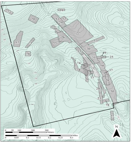
Figure 2.1) Map of easement boundary, DAR property boundary and National
Historic Landmark Boundary at Camden battlefield. The easement was agreed by Bowater and the KVLT based on research conducted
30
Steve Smith has a much larger office in SCIAA than Jim Legg does. The office has
the same miscellaneous items as Legg’s, but is also regularly littered with the tools the
archaeological trade, including a good number of metal detectors and GPS surveying
equipment. As the head of the institute, Smith is responsible for all the projects that his
archaeologists work on and so was well aware of Legg’s work at Camden. Shortly after
Legg had emailed his recommendations to Fields, the latter contacted Smith, at that time
the head of the Applied Research Division of SCIAA, and asked him to submit a bid for the
grant money the PCF had just received. Fields invited SCIAA archaeologists to bid for the
chance of creating a strategic plan for the site. As Field’s explained, “And that’s when we
put it out for bids, because when you deal with federal money that’s what you need to
do, but I wanted Steve Smith and Jim Legg to do it all along and they won the bid
project.”48 With his academic archaeological team secured, George Fields now turned his
attention to getting more grants for the project, while Legg and Smith began their work
discovering the Camden battlefield.
After a second grant, again from the American Battlefields Protection Program, the
archaeologists began their first in-depth study of the battlefield itself. The first process
that the archaeologists undertook did not involve metal-detectors but notepads. In order
to get a better sense of the battlefield, the two men decided to undertake Legg’s third
proposal first, and to interview the multitude of treasure hunters that had scavenged on
Camden battlefield for decades. Smith explained the process of their interviews, “we
48Fields, George. Interview with Gary Sellick. 10/19/2015. For the perspective of the SCIAA archaeologists
31
were able to build trust with about 14 collectors, ranging all the way from 70’s to the
2000’s and interview them and collectively we were able to pinpoint, or at least have a
general idea of where things (in the battle) were going to have happened.”49 This is not
to say that all the information given to them was useful in mapping the action of the battle.
Keen to find an untouched piece of land on which to search, a small number of relic
hunters in the 1980s searched a ridge that rises from the marshland to the northwest of
the De Kalb monument. In a thick stand of trees, over half a mile from the rumoured site
of the battle lines, they worked alone with their metal detectors. Against all odds, the
relic hunters made a huge discovery of artefacts, including a large number of gun parts,
uniform buttons and other Revolutionary War equipment. When Legg and Smith
interviewed these relic hunters, they were faced with an anomaly. The three relic hunters
who had searched this northern part of the battlefield had an entirely different narrative
of the battle than the others that were interviewed. Nonetheless, Jim Legg states that
they were able to explain away the inconsistency rather easily, “they were relative
latecomers to the battlefield in terms of relic hunting and wandered into an area that
nobody had ever really gotten into because it was off the battlefield essentially…you see
I think its in the American rear and it hadn’t been metal-detected badly.”50 In their 2005
report, Understanding Camden, Legg and Smith explained away the anomalous findings
49
Smith, Steve. Interview with Gary Sellick. Private Interview. Columbia, South Carolina and Camden, South Carolina, 09/11/2015. For more information on the process of the SCIAA interviews with collectors regarding the battlefield, including their methods, see; Legg et al., Understanding Camden, 46-59.
50
32
of the three relic hunters and their distorted view of the battle as the “Northern Solution.”
Overall, however, the process went smoothly and they gained a good idea of where to
start the search for the battle lines from the collecting patterns of these relic hunters.
In archaeology planning a dig may be important, but actual fieldwork is the
ultimate goal. Stuck in a stuffy office plotting the probable location of the Camden battle
site, both Smith and Legg wished to be out among the pines finding the evidence that
would support their theories. While they had conducted some sample fieldwork in 2004,
the SCIAA archaeologists had yet to search the site in detail. However, by the time that
the first archaeological report was nearing completion on the Camden battlefield, George
Fields had secured a third grant from the Save America’s Treasures fund, which would
actually allow Legg and Smith to conduct large-scale fieldwork at the site.51 It was the first
time that Save America’s Treasures had ever sponsored an archaeology project, so Smith
and Legg were determined to set a good example. Their eventual findings were published
in a report titled The Archaeology of Camden Battlefield in 2009. In consultation with the SCIAA archaeologists working on the battlefield, Fields was able to narrow down the land
that the PCF would want to actually purchase from Bowater. Since the start of the
easement negotiations, it had been clear that the company had no real imperative to keep
the land and so the Fields made his move.
51
33
At our interview at his suburban ranch house in Spartanburg, George Fields made
clear how important the archaeology was to the first purchase in 2002, “when you start
buying land you can’t afford to buy it all. You’ve got to set a priority on which land you
buy first and which is your highly essential land, which is of course the core of the
battlefield…that’s where you’ve got to do your research later in archaeology.”52 The
original preservation easement land, a 310-acre site that represented most of the land
that collectors had identified as the location of the original battle lines on the battlefield,
was the first piece of land to be purchased by the PCF. The land included all of that which
surrounded the DAR owned land on which the De Kalb monument stood. The money for
the purchase came from an open mortgage. The South Carolina Conservation Fund
eventually paid off the mortgage in 2007, five years after PCF formally took charge of the
management of the site.53 Now that the purchasing of land was complete and thus the
core battlefield area saved from possible destruction, the archaeologists could get to
work on surveying the site for interpretive purposes.
The metal detector is a relatively crude piece of equipment and is easy to use but
difficult to master. It works by a sensor probe being swept over the ground, beeping
whenever the user moves the probe over a metal object. The cheapest model can be
52Fields, George. Interview with Gary Sellick. 10/19/2015. After the purchase of the original easement
property, Fields used the archaeological findings of the SCIAA team in order to decide what other land to purchase. See; Legg, “The Camden Battlefield, 1996-2010,” 9.
53According to most people that I have spoken to about this initial land purchase, PCF agreed to become
34
purchased with a child’s pocket money in a toy store, the most expensive runs into
thousands of dollars. This device allowed Smith and Legg to conduct studies of the
Camden battlefield between 2003 and 2007. The main problem that the SCIAA crew faced
was that they were working over land that amateur metal detectorists had been picking
over for the previous thirty years.54 It is therefore a testament to the skill of the trained
archaeologists at SCIAA that so many new artefacts were discovered during their third
Camden project. In addition to metal detecting, the archaeological team also used GPS
mapping devices in order to mark the location of their finds (see Fig 2.2).
When the crew first arrived, dressed in their work clothes and carrying a mixture
of hi-tech equipment and gardening tools, the Camden battlefield represented a
formidable obstacle to their mission. “The areas that are cut now looked like Cambodia.”
Legg explained, “And when we did finally go back out it was 2003, I guess, for the third
project we had to use a mower to cut things down.”55 For long periods, it seemed that
the battlefield itself controlled how it released its secrets, with the overgrown areas
largely inaccessible to the archaeologists. The sporadic nature of the investigation is
shown on the GPS map created by the team.
Often Smith and Legg would arrive on the battlefield to find whole areas of pine
forest and undergrowth engulfed in flame. George Fields used mowing and controlled
burns to tame the wilderness of Camden battlefield, and the clearing that resulted gave
54In fact, many relic hunters had actually considered the site “hunted out” in the years before the SCIAA
fieldwork began. See; Legg et al., Understanding Camden, 74.
55Legg, Jim. Interview with Gary Sellick. 09/21/2015. For more on the methods used by the SCIAA team to
35
the archaeologists the perfect conditions to survey the land. Thus, where Fields mowed
and burned, the archaeologists followed. In consequence, despite planning their
investigation using the tried and tested method of pre-planning large rectangular dig
spots the actual investigation did not follow this pattern in any real way. “What we ended
up doing was largely reactive,” says Legg, “because George would burn something off and
that is what we would cover.”56 However, despite the haphazard method that the
archaeologists were forced to employ, they were very happy with their results, which
confirmed many of their original hypotheses in regards to where the battle was actually
fought (See Fig 2.3).57
Rooting through the ashes and smouldering earth, the archaeologists were able
to make some outstanding finds. As well as their success in finally marking the battle lines
that existed throughout the battle, the archaeology was able to unearth over a thousand
pieces of Revolutionary War era material that had been buried for over two centuries.
This was quite surprising considering the many years of amateur collection that took place
at the site before the modern preservation effort began. When asked what the teams
they led at the site had found, Steve Smith listed, “primarily lead shot from British Short
Land Pattern muskets, musket balls and buckshot from French Charleville muskets. Very,
56
Legg, Jim. Interview with Gary Sellick. 09/21/2015.
57
36
37
very little rifle shot out there. A few buttons. The occasional buckles, and horseshoes.”58
Most of these items were given to the Camden History Museum where they are currently
preserved, and some are on display in the institution.
Things did not always go smoothly during the dig. Legg and Smith were filled with
horror when they arrived early one summer’s morning in 2004 to find the sun rising on a
huge manmade berm running along the highway opposite the De Kalb monument. The
mound was constructed from earth that had yet to be surveyed by the team, its artefacts
lost forever due to a miscommunication. George Fields had wanted to clear the area for
visitors. Unfortunately, he did so without checking first with the archaeologists. By doing
this, Fields inadvertently created a human-built oddity (a 200-foot long push pile) right in
the center of the battlefield which remains a feature of the site to this day.
Overall, however, the archaeological investigation of the battlefield had been
successful. The team was able to achieve 100% coverage of 36.7 acres of the core
battlefield and to achieve smaller levels of coverage throughout the site.59 In doing so,
they had mapped out for the first time the likely positions of both armies throughout the
battle, providing a crucial tool for interpretation. This discovery was perhaps the biggest
58
Smith, Steve. Interview with Gary Sellick. 09/11/2015. Overall, the SCIAA dig found 1165 new artefacts on the Camden battlefield, most being fired and unfired ammunition. See; Smith et al., The Archaeology of Camden Battlefield, 84.
59Jim Legg, “The Camden Battlefield.” 9. For more information on the total area covered by the SCIAA
38