A hybrid method to determine a local geoid model—Case study
Yong-Qi Chen and Zhicai Luo
Department of Land Surveying and Geo-Informatics, The Hong Kong Polytechnic University, Kowloon, Hong Kong, China
(Received July 7, 2003; Revised March 19, 2004; Accepted March 19, 2004)
This paper studies the methodology to construct an accurate local/regional geoid model. To achieve the objective an integration of all the information/data available must be performed. A hybrid approach of so-called sequential processing is employed in this study. It involves three steps: the construction of a gravimetric geoid using the well-known remove-restore technique; the least squares fitting of 3-parameter transformation to remove the bias and tilts between the gravimetric geoid and GPS/leveling data; further refinement of the geoid model with GPS/leveling data and other information. The study is focused on the last step of signal extraction. The proposed approach was used in the determination of the Hong Kong geoid model and the Shenzhen geoid model. Their accuracy was evaluated with independent GPS/leveling data. These case studies indicate that the absolute accuracy of a centimeter and relative accuracy of some 1 part per million (ppm) of a local geoid model are achievable if the methodology is carefully designed and all the information/data are fully utilized.
Key words:Hybrid method, local geoid model.
1.
Introduction
Determination of the geoid has been one of the main re-search areas in geodesy for several decades. More and more accurate geo-potential models have been developed. With the development of GPS positioning techniques, a great at-tention has been paid to the precise determination of lo-cal/regional geoids, aiming at replacing the geometric lev-eling with GPS surveys (e.g., Engeliset al., 1985). Several methods have been developed, which can be classified into two basic approaches: the geometric approach and the gravi-metric approach.
The geometric approach is to use the known “geoid heights” at some points, which are derived from co-located GPS-determined heights and leveled heights (here-after called “observed” geoid height), to interpolate the geoid heights at other points. “Geoid height” used in this pa-per refers to the difference between the WGS-84 ellipsoidal height and the leveled height with respect to a local vertical datum. The interpolation can be done graphically or ana-lytically. Yanalak and Baykal (2001) discuss several meth-ods of analytic interpolation. Usually, a plane or low or-der polynomial is used to model the geoid (e.g., Feather-stoneet al., 1998). The geometric method has been widely used in engineering projects with an area up to tens kilo-meters squared. The accuracy of the geoid so established depends on several factors, like the distribution and num-ber of GPS/leveling stations, characteristics of the geoid in the region, the method of interpolation, and the accuracy of GPS/leveling data. The gravimetric approach is to determine a geoid model using gravity measurements. The well-known remove-restore technique is commonly used, which is well
Copy right cThe Society of Geomagnetism and Earth, Planetary and Space Sciences (SGEPSS); The Seismological Society of Japan; The Volcanological Society of Japan; The Geodetic Society of Japan; The Japanese Society for Planetary Sciences; TERRA-PUB.
documented (e.g., Moritz, 1983; Torge, 2001).
In order to determine a precise local geoid, a full advan-tage of all types of data/information must be taken in an in-tegrated solution. This paper studies the methodology for such a solution using the data in two areas. One is Hong Kong territories of about 1000 kilometers squared, and the other is Shenzhen of over 2000 kilometers squared in the Southern China. Shenzhen neighbors Hong Kong with dif-ferent vertical datum. The paper first reviews and discusses the methods for integrating heterogeneous data in geoid de-termination. Then the results of the two study areas with the proposed method are presented and analyzed.
2.
The Methodology
2.1 Integrated approachThe rigorous approach for the integration of heteroge-neous data/information is to express different types of in-formation/data (e.g., gravity measurements, coefficients of a geo-potential model, topographical data, and GPS/leveling surveys) as functions of geoid heights and solve for them. However, it involves complicated functional models and stochastic models (weighting of different types of informa-tion). Thus, other approaches, though approximate, have been developed for practical uses.
The first kind of integration is to incorporate a potential model and local terrain information into the geo-metric approach (Doerflingeret al., 1997; Yang and Chen, 1999). The approach is similar to the remove-restore tech-nique used in the gravimetric approach. Let the geoid height
Nbe separated into three componentsNG M,NI andNT:
N =NG M+NI +NT (1)
where NG M is the long-wavelength component calculated from a geo-potential model,NT is the terrain correction cal-culated from the topography information, e.g., a digital
rain model (DTM), andNI is the medium wavelength com-ponent evaluated by an interpretation technique. Values of
NI at GPS/Leveling stations can be calculated from the ob-served geoid heightsNas
NI =N−NG M−NT (2)
The valuesNI at these GPS/leveling stations are then used to interpolate the corresponding valuesNIat any other points. After the predicted valuesNIare obtained, the geoid heights
Nat the predicting points are computed by adding the long-wavelength componentNG Mand the terrain correctionNT at these predicting points:
N=NG M+NI+NT(3) (3)
The case study over Hong Kong shows that the approach can significantly improve the accuracy of the geoid compared with the pure geometric method (Yang and Chen, 1999).
The second kind of integration is to transform a gravimet-ric geoid model for better fitting to the GPS/leveling data. The gravimetric geoid is first constructed using gravity mea-surements with the remove-restore technique. As there may exist systematic biases between the constructed gravimetric geoid and the GPS/leveling derived geoid, a transformation of 4 parameters (e.g., Fotopoulos et al., 1999; Fotopoulos
et al., 2003) or 3 parameters (Yang and Chen, 2001) is then applied to the gravimetric geoid using the observed geoid heights (the resultant geoid is hereafter called the “trans-formed” gravimetric geoid). Although the biases may come from both kinds of geoid models, the transformation is nec-essary if the constructed geoid model is mainly used for GPS leveling. This procedure is also used when the accuracy of a gravimetric geoid is to be evaluated by the observed geoid heights (e.g., Fotopouloset al., 1999; Forsberget al., 1997). Since this procedure can improve the fitting of a gravimetric geoid with respect to GPS/leveling data, Featherstoneet al.
(1998) refer it as the combined gravimetric-geometric method.
The above two kinds of integration, however, do not take full advantage of all the data/information available. The first one does not use gravity measurements. While the second one, though taking into account the general trend of the sep-aration between the constructed gravimetric geoid and the observed geoid heights, does not fully utilize all the infor-mation/data. After the least squares fitting of the constructed gravimetric geoid into the observed geoid heights, the resid-uals (i.e., the differences between the transformed gravimet-ric geoid heights and observed geoid heights) may not be completely random. Some useful signals may exist, which should be extracted to further improve the accuracy of the geoid model.
We therefore propose an approach of three-step procedure to be used:
1) Construct a gravimetric geoid using the above-mentioned gravimetric approach. The gravimetric geoid is usually given at regular grid points;
2) Remove the bias and tilts of the gravimetric geoid model with respect to GPS/leveling data by using the least squares fitting, i.e., three-parameter least squares transformation;
3) Signal extraction. This study concentrates on the meth-ods to attract useful signals from the differences be-tween the transformed gravimetric geoid model and the observed geoid heights, which is discussed below.
2.2 The methods for signal extraction
There are several possible methods for signal extraction to refine the gravimetric geoid. A popular approach is the least square collocation (LSC). The LSC separates the difference
d Ni between the transformed gravimetric geoid height and the observed geoid height at a point into signal and noise parts. The signals at the grid points can be predicted from all thed Nvalues through a covariance function. The predicted signals are then added to the transformed gravimetric geoid heights, resulting in a refined geoid model. LetdNbe vector of the differences at all GPS/leveling stations. The signalsp at any grid pointpcan be calculated by
sp=cTp(C+D)−
1
dN (4)
wherecp is a vector whose elements are the covariance of the signal at grid point p and those at all GPS/leveling sta-tions,CandDare the covariance matrix of signals among the stations and the variance matrix of noises at the stations, re-spectively. The difficulty with the LSC lies in the selection of a covariance function. The empirical method can work, but needs large amount of GPS/leveling data to get a meaningful and reliable covariance function. Alternatively, one may ar-bitrarily select a function, e.g., Gauss function, as covariance function, but the results will vary with the selection. Fukuda
et al.(1997) and Featherstone (2000), for instance, employed the LSC approach to refine the geoid of Japan JGEOID93 and the geoid of Perth region in Australia, respectively.
The second method is to use a multi-quadratic interpo-lation function (Hardy, 1975) to establish a refined geoid model. The function reads a kernel function (or a surface),t is number of data points used in the interpolation, andαjthe coefficients to be deter-mined from data points. The surfaces mentioned in Hardy (1975) include circular hyperboloids in two sheets, circular paraboloids, and right cones.
The third method is the weighted average. Corrections (or signals) to the transformed gravimetric geoid heights at grid points can be computed usingd N at the GPS/leveling stations with a weighted average method. There are various weighting schemes.
-2
Fig. 1. The empirical covariance function.
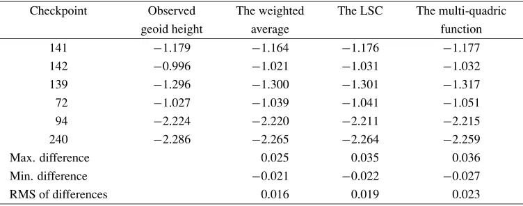
Table 1. Estimated geoid heights at checkpoints with the three methods (in meter).
Checkpoint Observed The weighted The LSC The multi-quadric
geoid height average function
Max. difference 0.025 0.035 0.036
Min. difference −0.021 −0.022 −0.027
RMS of differences 0.016 0.019 0.023
see which of the above three methods can provide better re-sults for the area. 31 GPS/leveling stations whose observed geoid heights have better accuracy were selected and 6 of them were used as checking points. The above-mentioned three methods were evaluated with the following details:
1) The weighted average method: the weight is defined as Pi = (1/ri)3, whereri is the distance between the computation point and running point. The power of 3 was selected from empirical tests;
2) The least square collocation: the discrepanciesd N at the 31 GPS stations were used to formulate an empirical covariance function. Figure 1 is a plot of the covariance function approximated with the cubic-spline;
3) The circular hyperboloid withδ=5 km was used as sur-face in the multi-quadric method, i.e.,θ(x,y;xj,yj)= [(x−xj)2+(y−yj)2+δ2]1/2.
The results are given in Table 1, where the difference is the observed value minus the estimated. It can be seen from the table that the weighted average method provides a better result and at the same time is simpler.
3.
Case Study
The authors completed the project of the determination of Hong Kong local geoid HKGEOID-2000 funded by the Hong Kong Research Grant Council and worked as
consul-tants for the project of the determination of Shenzhen geoid SZGEOID-2001, funded by the Department of Lands, Gov-ernment of Shenzhen, China. The developed methodology and software for the Hong Kong project were used in the Shenzhen project.
3.1 Data used for the HKGEOID-2000 and SZGEOID-2001
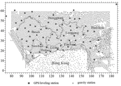
grav-Fig. 2. Distribution of GPS/leveling stations and gravity measurement points (the coordinates in km are in Hong Kong 1980 grid system).
(a)
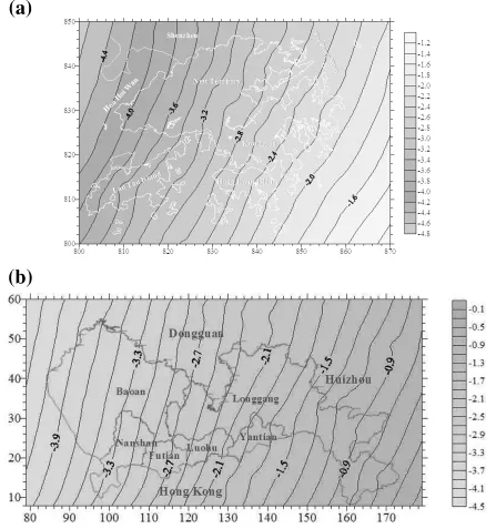
(b)
Fig. 4. (a) HKGEOID-2000. (b) SZGEOID-2001.
ity measurements and GPS/leveling stations.
Shenzhen is one of the special economic zones in China with area of 2020 km2. It is on the north of Hong Kong. There are 65 GPS/Leveling stations with average spacing of 10 km. According to the data provider, Department of Lands of Shenzhen Government, the observed geoid heights are of accuracy of 1–2 cm. The GPS-determined heights are referred to WGS-84 ellipsoid and the leveled heights are in normal height system and referred to the 1956 Yellow Sea Datum. The gravity measurements used include 3608 observations on land with accuracy of 0.1 mGal and 1262 in sea with accuracy of 1.6 mGal. The gravity stations are spaced by 1 km. In the determination of Shenzhen geoid 298 gravity measurements on land and 45 in sea in Hong Kong territories were included. Figure 3 shows the distribution of these gravity measurement points and GPS/leveling stations.
3.2 Construction of HKGEOID-2000 and SZGEOID-2001
(a)
(b)
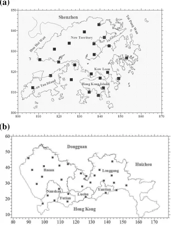
Fig. 5. (a) Distribution of Check Points in Hong Kong (Hong Kong coordinate system in km). (b) Distribution of Check Points in Shenzhen (Shenzhen coordinate system in km).
transformed gravimetric geoid height N and the original gravimetric geoid heightNare related as
N(x,y)=N(x,y)+a0+a1x+a2y (6) where x and yare grid coordinates of a point, a0,a1, and
a2are bias, tilt in thex-direction, and tilt in they-direction, respectively. The transformed geoid model is finally refined using a special weighted average, called local Shepard sur-face fitting method:
s(xP,yP)= ⎧ ⎨ ⎩ n i=1
d N(xi,yi)·K(ri)m/ n i=1
K(ri)m,ri =0
d N(xi,yi), ri =0
(7) where d N is the difference between the observed geoid height and the transformed gravimetric geoid height,riis the distance between interpolating point (xP,yP)(grid points)
and known point(xi,yi)(GPS/leveling stations), mthe fit-ting power should be integer (m =1,2,· · ·), andK(ri)the kernel function or so-called weighting function, i.e.,
K(r)=
⎧ ⎨ ⎩
1/r, 0<r ≤D/3 27
4D( r D −1)
2, D/3<r≤ D
0, r>D
(8)
withDbeing interpolating or searching radius. The values
at a grid point is then added to the transformed geoid height, resulting in the refined geoid model. The values D andm
for the Shepard fitting and 1/r for the simple weighting scheme used in Section 2.2. The other reason is that we consider that the signals are of local nature and therefore the
d N at points closer to interpolating point should have much more significant contributions. One can see from Eq. (8) that when r > D/3 the weight function K(r)is smaller than that of the simple weighting scheme, which follows more closely the above consideration. With the Shenzhen data we have found that the better results can be achieved ifm =3 and D = 50 km. These values were used for both study areas. Actually, there should be no much difference between the simple weighting scheme and the Shepard fitting method for the study areas, for the selected m of 3 is larger. The simple weighting scheme was also applied to the Shenzhen data and did not produce significantly different results. The final geoid models for both regions are given in Fig. 4(a) and (b).
3.3 Evaluation and analysis of the accuracy of the two geoid models
The constructed geoid models HKGEOID-2000 and SZGEOID-2001 were thoroughly evaluated before they were released for practical uses. The authorities concerned did in-dependent and accurate GPS and leveling surveys at 22 sta-tions in Hong Kong and 29 in Shenzhen, which do not coin-cide with the stations used for the construction of the geoid models. They are referred as checkpoints. Figure 5(a) and (b) show their distribution.
A geoid model was evaluated with two measures: absolute agreement and relative agreement with the observed geoid heights. These two agreements were evaluated for both the transformed gravimetric geoid and refined geoid models (the final models), from which the accuracy of the final geoid models and the efficiency of the signal extraction process can be obtained. Table 2 lists the statistics of the residuals after the least squares fitting of the gravimetric geoid models into observed geoid heights. The residuals are the discrepan-cies between the observed geoid heights and the transformed gravimetric geoid model. The standard deviation measures the absolute agreement of the transformed gravimetric geoid model with the GPS/leveling data. The absolute agreement was also evaluated at checkpoints. The differences between the observed geoid heights and the transformed gravimetric geoid heights at checkpoints were computed and their statis-tics is listed in Table 3. The standard deviation also measures the absolute agreement of the transformed gravimetric geoid model with GPS/leveling data. The value in Table 3 can be considered as external measure, because the observed geoid heights at checkpoints are not included in the construction of a geoid model; while the value in Table 2 is regarded as internal measure. To assess the efficiency of the proposed hybrid approach, the differences between the observed geoid heights and the refined geoid heights at the checkpoints were computed. Table 4 gives their statistics in the sense of abso-lute agreement. In order to evaluate the relative agreement of a geoid model with GPS/leveling data, the geoid height dif-ferences among the checkpoints were computed for both the transformed gravimetric geoid models and final geoid mod-els and then compared with the observed ones. The results are given in Tables 5 and 6. From the results following ob-servations can be made:
Table 2. Statistics of the residuals after the 3-parametr least squares fitting (unit: m).
Max Min STD
Hong Kong 0.056 −0.081 0.026
Shenzhen 0.051 −0.083 0.028
Table 3. Statistics of the differences between the transformed gravimetric geoid heights and the observed ones at checkpoints (unit: m).
# of check points Max Min STD
Hong Kong 22 0.034 −0.053 0.022
Shenzhen 29 0.041 −0.061 0.019
Table 4. Statistics of the differences between the final geoid heights and observed ones at check points (unit: m).
# of check points Max Min STD
Hong Kong 22 0.031 −0.025 0.017
Shenzhen 29 0.026 −0.022 0.014
1) The external measure of the absolute agreement of the transformed geoid with GPS/leveling data is very sim-ilar for both areas, i.e., 22 mm for Hong Kong and 20 mm for Shenzhen. The internal measure is also similar for both areas, but a little bit larger than the external one, i.e., 27 mm for Hong Kong and 28 mm for Shenzhen.
2) The absolute agreement of the final geoid model HKGEOID-2000 with the GPS/leveling data at the checkpoints is 17 mm, and 14 mm for SZGEOID-2001. The refinement process (step 3) improved the agree-ment from 22 mm to 17 mm by 23% for Hong Kong geoid, and from 20 mm to 14 mm by 30% for Shenzhen geoid.
3) Improvement of the relative agreement is also signif-icant. The overall relative agreement for Hong Kong geoid is improved from 2 ppm to 1.7 ppm by 15%, and for Shenzhen from 1.4 ppm to 1.1 ppm by 21%.
4) The above (2) and (3) indicate that the proposed sig-nal extraction method works well and can significantly improve the accuracy of geoid.
5) The above values of agreement are affected by the er-rors of observed geoid heights at checking points. To estimate the accuracy of the constructed geoid mod-els we must know the errors of the observed geoid heights. For simplicity we assume that the observed geoid heights at checkpoints have similar size of er-ror as the constructed geoid model. With such an as-sumption, the HKGEOID-2000 has absolute accuracy of 12 mm and overall relative accuracy of 1.2 ppm; the SZGEOID-2001 has absolute accuracy of 10 mm and relative accuracy of 0.8 ppm.
Table 5. Statistics of the differences between modeled and observed geoid height differences among 22 checkpoints in Hong Kong.
Baseline Length No. of height RMS-1 Relative-1 RMS Relative
(km) diff. (mm) (ppm) (mm) (ppm)
0∼5 5 18 7.2 19 7.6
5∼10 27 27 3.6 21 2.8
10∼15 21 26 2.1 25 2.0
15∼20 33 32 1.8 21 1.2
20∼25 28 40 1.8 29 1.3
25∼30 33 35 1.3 26 0.9
30∼35 22 26 0.8 25 0.8
Overall Statistics 169 31* 2.0* 24* 1.7*
Note that: (1) columns RMS-1 and relative-1 are referred to the transformed gravimetric geoid; while columns RMS and relative are referred to the final geoid; (2) * weighted average value with weight being the number of height differences.
Table 6. Statistics of differences between modeled and observed geoid height differences among 29 checkpoints in Shenzhen.
Baseline Length No. of height RMS-1 Relative-1 RMS Relative
(km) diff. (mm) (ppm) (mm) (ppm)
0∼5 5 21 8.4 17 6.8
5∼10 47 24 3.2 19 2.5
10∼15 54 21 1.7 19 1.5
15∼20 60 22 1.3 19 1.1
20∼25 55 24 1.1 18 0.8
25∼30 49 27 1.0 18 0.7
30∼35 43 30 0.9 19 0.6
35∼40 31 31 0.8 20 0.5
40∼45 25 38 0.9 17 0.4
45∼50 16 30 0.6 15 0.3
>50 21 48 0.9 26 0.5
Overall Statistics 406 27* 1.4* 19* 1.1*
Note that: (1) columns RMS-1 and relative-1 are referred to the transformed gravimetric geoid; while columns RMS and relative are referred to the final geoid; (2) * weighted average value with weight being the number of height differences.
great deal to resurvey GPS and leveling and conduct dense gravity measurements for the purpose, while Hong Kong geoid was constructed only through collect-ing existcollect-ing data which were used for other purposes.
4.
Conclusion Remarks
Advantage of all data/information must be taken as much as possible to construct a precise geoid model. The posed methodology of three-step sequential processing pro-cedure is simple and works well. It involves the construc-tion of a gravimetric geoid using the well-known remove-restore technique, the least squares fitting of the gravimetric geoid with respect to GPS/leveling data to remove bias and tilts (3-parameter transformation), and the signal extraction to further improve the transformed gravimetric geoid. The last step is of particular importance to construct a precise geoid model. There are various methods for the purpose of signal extraction, but no one can be claimed superior over others for all the cases. Careful tests on an area of inter-est must be conducted to select a better method. The study of two areas, Hong Kong and Shenzhen, shows that
refine-ment process (the signal extraction) can improve the abso-lute agreement of Hong Kong and Shenzhen geoid models with their GPS/leveling data by 23% and 30%, respectively; while it improves the relative agreement of Hong Kong and Shenzhen geoid models by 15% and 21%, respectively. This improvement is significant. Using the proposed procedure, both HKGEOID-2000 and SZGEOID-2001 achieve the level of centimeter accuracy and about 1 ppm relative accuracy, which is good for GPS leveling.
Acknowledgments. This project has been sponsored by The Hong Kong Research Council (project PolyU 5069/99E, A/C number BQ-328).
References
Doerflinger, E., Z. Jiang, H. Duquenne, and R. bayer, Determination of the quasi-geoid in a mountainous area: example of eastern Pyrenees (France), inGravity, Geoid and Marine Geodesy,edited by J. Segawa, H. Fujimoto, and S. Okubo, pp. 643–650, Springer, 1997.
1985.
Featherstone, W. E., Refinement of gravimetric geoid using GPS and level-ing data,Journal of Surveying Enginnering,126(2), 27–58, 2000. Featherstone, W. E., M. C. Dentith, and J. F. Kirby, Strategies for the
ac-curate determination of orthometric heights from GPS,Survey Review, 34(267), 278–296, 1998.
Forsberg, R., J. Kaminskis, and D. Solheim, Geoid of the Nordic and Baltic region from gravimetry and satellite altimetry, inGravity, Geoid, and Ma-rine Geodesy,edited by J. Segawa, H. Fujimoto, and S. Okubo, pp. 540– 547, Springer, 1997.
Fotopoulos, G., C. Kotsakis, and M. G. Sideris, A new Canadian geoid model in support of leveling by GPS,Geomatica,53(4), 53–62, 1999. Fotopoulos, G., W. E. Featherstone, and M. G. Sideris, Fitting a gravimetric
geoid model to the Australia height datum via GPS data, Manuscript obtained from the second author, 2003.
Fukuda, Y., J. Kuroda, Y. Takabatake, J. Itoh, and M. Murakami, Improve-ment of JGEOID 93 by the geoidal heights derived from GPS/leveling surveys, inGravity, Geoid, and Marine Geodesy,edited by J. Segawa, H. Fujimoto, and S. Okubo, pp. 589–596, Springer, 1997.
Hardy, R. L., Research results in the application of multi-quadric equations to surveying and mapping problems,Surveying and Mapping,35(12), 321–332, 1975.
Luo, Z. C. and Y. Q. Chen, Evaluation of geo-potential models EGM96, WDM94, and GPM98CR in Hong Kong and Shenzhen region,Journal of Geo-spatial Engineering,4(1), 21–30, 2002.
Moritz, H., Local geoid determination in mountainous areas, OSU Rep. No 353, Department of Geodetic Science and Surveying, the Ohio State University, Ohio, USA, 1983.
Ning, J. S., J. C. Li, D. B. Chao, and Z. L. Guan, The Research of the earth’s gravity field model WDM94,Journal of Wuhan Technical University of Surveying and Mapping,19(4), 283–291, 1994.
Torge, W.,Geodesy, third edition, Walter de Gruyter, 416 pp, 2001. Yanalak, M. and O. Baykal, Transformation of ellipsoid heights to local
lev-eling heights,Journal of Surveying Engineering,127(3), 90–103, 2001. Yang, Z. J. and Y. Q. Chen, Determination of local geoid with the geometric
method—a case study,Journal of Surveying Engineering,125(3), 136– 146, 1999.
Yang, Z. J. and Y. Q. Chen, Determination of Hong Kong gravimetric geoid,
Survey Review,36(279), 23–34, 2001.