Soumyabrata Dev1,3, Florian M. Savoy2, Yee Hui Lee1, and Stefan Winkler2
1School of Electrical and Electronic Engineering, Nanyang Technological University (NTU), 639798 Singapore 2Advanced Digital Sciences Center (ADSC), University of Illinois at Urbana-Champaign, 138602 Singapore 3ADAPT SFI Research Centre, Trinity College Dublin, Ireland
Correspondence:Stefan Winkler ([email protected]) Received: 10 May 2017 – Discussion started: 27 September 2017
Revised: 14 February 2018 – Accepted: 23 February 2018 – Published: 11 April 2018
Abstract. Sky–cloud images obtained from ground-based sky cameras are usually captured using a fisheye lens with a wide field of view. However, the sky exhibits a large dynamic range in terms of luminance, more than a conventional cam-era can capture. It is thus difficult to capture the details of an entire scene with a regular camera in a single shot. In most cases, the circumsolar region is overexposed, and the regions near the horizon are underexposed. This renders cloud seg-mentation for such images difficult. In this paper, we propose HDRCloudSeg – an effective method for cloud segmentation using high-dynamic-range (HDR) imaging based on multi-exposure fusion. We describe the HDR image generation pro-cess and release a new database to the community for bench-marking. Our proposed approach is the first using HDR ra-diance maps for cloud segmentation and achieves very good results.
1 Introduction
Clouds are important for understanding weather phenom-ena, the earth’s radiative balance and climate change (IPCC, 2013; Stephens et al., 2012). Traditionally, manual observa-tions are performed by cloud experts at WMO (World Me-teorological Organization) stations around the world. Such manual methods are expensive and prone to human error. Weather instruments, viz. ceilometers, are useful in under-standing the vertical profile of the cloud formation. However, they are point-measurement devices and can provide cloud information along a particular slant path through the atmo-sphere. Satellite sensors are also extensively used in moni-toring the earth’s atmosphere. However, satellite images
typ-ically suffer from either low temporal or low spatial resolu-tion.
Recently, ground-based cloud observations using high-resolution digital cameras have been gaining popularity. Whole-sky imagers (WSIs) are ground-based cameras cap-turing images of the sky at regular intervals with a wide-angle (fisheye) lens. They are able to gather high-resolution and localized information about the sky condition at frequent intervals. Due to their low cost and easy setup, their popular-ity among research groups working in several remote sensing applications is growing. One of the earliest sky cameras was developed by the Scripps Institute of Oceanography at the University of California San Diego (Kleissl et al., 2016). It was used to measure sky radiances at various wavelengths. Nowadays, commercial sky cameras are also available; how-ever, they are expensive and offer little flexibility in their us-age. Therefore, we have built our own custom-designed sky cameras with off-the-shelf components (Dev et al., 2014b). We use them extensively in our study of clouds in Singapore. The instantaneous data of cloud formations they provide are used for understanding weather phenomena, predicting so-lar irradiance (Fua and Cheng, 2013; Dev et al., 2016), pre-dicting the attenuation of communication links (Yuan et al., 2014) and contrail tracking (Schumann et al., 2013).
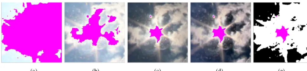
Figure 1.Proposed HDRCloudSeg cloud segmentation approach.(a)High-(b)medium- and(c)low-exposure low-dynamic-range (LDR) images;(d) high-dynamic-range (HDR) image (tone-mapped for visualization purposes);(e)binary output of HDRCloudSeg. Saturated pixels in all images are shown in pink. The number of saturated pixels is significantly reduced in the HDR image, without compromising on the fine cloud details.
sunny and clear day, it is difficult to capture the entire lu-minance range of the sky scene using a low-dynamic-range (LDR) image. Yankee Environmental Systems sells a well-known commercial sky camera model (TSI-880) (Long et al., 2001). It is a fully automated sky imager, used in continuous monitoring of the clouds. Its on-board processor computes the cloud coverage and sunshine duration and stores these results for the user for further processing. However, such im-agers only capture LDR (8-bit) images.
One of the earliest attempts to capture more of the DR of the sky was done by Stumpfel et al. (2004). They presented a framework in which a set of exposure settings along with neutral density filters is used to generate an high-dynamic-range (HDR) composite map. Kenny et al. (2006) used a digital camera to estimate the whole-sky luminance distribu-tion for different sky condidistribu-tions. Attempts to provide a full spherical HDR view of the sky–cloud condition were done by mounting hemispherical sky cameras on the top and bot-tom of airships (Okura et al., 2012). Gryaditskya et al. (2014) used HDR captures of the sky to recover absolute luminance values from images. To the best of our knowledge, there is no prior work that uses the capability of HDR imaging for better segmentation of sky–cloud images.
Several techniques for cloud segmentation exist, but they are designed for conventional LDR images. Long et al. (2006) developed a method based on fixed thresholding. As clouds have a non-rigid structure, traditional segmentation algorithms based on shape priors are not applicable. Color is generally used as a discriminating feature in cloud segmen-tation (Li et al., 2011; Souza-Echer et al., 2006; Mantelli-Neto et al., 2010). Li et al. (2011) used a hybrid threshold-ing approach that employs both fixed and adaptive thresh-olds, depending on the bimodality of the input image. Long et al. (2006) modeled atmospheric scattering by calculating the ratio of red and blue color channels. Souza-Echer et al. (2006) defined appropriate thresholds in the saturation chan-nel of the intensity–hue–saturation color model. Mantelli-Neto et al. (2010) used a multi-dimensional Euclidean dis-tance to determine the locus of sky and cloud pixels.
The motivation of this paper is to propose high-dynamic-range imaging (HDRI) for cloud segmentation using ground-based sky cameras. We detail the process of image capture and storage in our sky camera system. We show that using HDR cloud imaging significantly reduces the amount of sat-urated pixels in an image and is therefore an efficient manner to capture the circumsolar region. Furthermore, HDR imag-ing generally provides better segmentation results as com-pared to LDR images, regardless of the segmentation method used. In this paper, we show how to improve segmentation results by capturing a larger DR of the sky using HDRI tech-niques. We then introduce HDRCloudSeg, a graph-cut-based segmentation algorithm that uses the HDR radiance map for accurate segmentation of sky–cloud images.
Figure 1 summarizes our proposed approach.
The main novel contributions of the present paper include the following:
– An HDR capture process is introduced for better cloud imaging as compared to conventional LDR images. This includes methods and procedures to capture a larger part of the dynamic range of a sky scene and archiving the obtained images efficiently.
– A graph-cut=based segmentation algorithm is proposed that offers better performance as compared to the state-of-the-art approaches.
– A database is released comprising high dynamic cap-tures of the sky scene, along with their manually anno-tated ground-truth segmentation maps.
1/1600 s;(c)−4 EV, 1/4000 s.(d)HDR image computed by fusing the pictures(a–c)(tone-mapped for visualization purposes).
2 HDR image generation
WAHRSIS, our custom-designed sky imager, is composed of a digital single-lens reflex (DSLR) camera with a fisheye lens. The camera is controlled by a single-board computer housed inside a box with a transparent dome. Our first model (Dev et al., 2014b) used a moving sphere mounted on two motorized arms to block the direct light of the sun. We re-moved this from our latest models in favor of HDR imaging (Dev et al., 2015b). In this way, we avoid potential mechani-cal problems as well as occlusions in the resulting images.
Typical cameras can only capture an 8-bit LDR image. Therefore, we use the exposure bracketing option of our cam-eras to capture three pictures at 0,−2 and−4 exposure value (EV) in quick succession. The aperture remains fixed across all captured images, while the shutter speed automatically adapts to match the appropriate exposure. Figure 2 shows an example of the captured images at varying exposure lev-els. An LDR image taken at low exposure (see Fig. 2c) has few saturated pixels in the circumsolar region but is underex-posed in the regions further from the sun. However, a high-or medium-exposure LDR image (see Fig. 2a, b) can cap-ture the near-horizon regions well, but the circumsolar area is overexposed and saturated.
The different LDR images can then be fused together into a single, HDR radiance map. We use the Debevec and Ma-lik (1997) algorithm to recover the HDR radiance map from LDR images. While the radiance map can be analyzed com-putationally, it cannot be viewed directly on a conventional (LDR) display. Therefore, for the purpose of visualization, we tone-map the HDR radiance map into a conventional 8-bit LDR image using contrast-limited adaptive histogram equal-ization (CLAHE) (Zuiderveld, 1994). It involves a logarith-mic transformation of the higher DR radiance map to a lower 8-bit display. This produces a perceptually recognizable im-age, because the response of the human eye to light is also logarithmic. This operation compresses the DR by preserv-ing the details in the image. Figure 2d shows an example of a tone-mapped image.
We also perform the HDR fusion and tone-mapping on a server that collects the images from all our WSIs. Since we have three imagers capturing multiple exposures every
2 min, we need algorithms which are computationally ef-ficient. Therefore, we use the GPU implementation as de-scribed by Akyüz (2015). It relies on the OpenGL API to perform the entire HDR pipeline on the GPU. It consists of HDR fusion, which is detailed in Akyüz (2015), followed by tone-mapping, which is based on the photographic tone re-production operator of Reinhard et al. (2002). Generating an 18-megapixel HDR image and its tone-mapped version takes less than 7 s, compared to several minutes with standard CPU algorithms.
For storage efficiency, we compress our HDR images us-ing the “JPEG-XT” format (Richter, 2013).1JPEG-XT is an extension of JPEG currently being developed for HDR im-ages. An important advantage of JPEG-XT format is that it is backward compatible to the popular JPEG compression tech-nique. It consists of a base layer that is compatible with the legacy systems and an extension layer that provides the full DR. Using JPEG-XT at a quality level of 90 %, we obtain a file size of about 8 MB. This represents a significant im-provement compared to the common “RGBE” format, which would require 50 MB per image by storing every pixel with 1 byte per color channel and 1 byte as a shared exponent.
3 Cloud segmentation using HDRI
We propose a graph-based segmentation algorithm called HDRCloudSeg that formulates the sky–cloud segmentation task as a graph-partitioning problem. Graph-cutting for cloud segmentation was proposed earlier by Liu et al. (2015b). However, Liu et al. (2015b) used conventional LDR images in their segmentation framework and generated seeds using Otsu threshold (Otsu, 1979). Furthermore, they did not con-sider the circumsolar regions in their evaluation.
3.1 Notation
Suppose that the low-, medium- and high-exposure LDR sky–cloud images are represented byXLi,XMi andXHi , re-spectively, andi=1, . . ., N, whereN is the total number of 1We use the reference software source code available at https:
Figure 3.Illustrative example to demonstrate the probability of a pixel belonging to the “cloud” category.(a)Sample sky–cloud image. (b)Normalized (B−R)/(B+R) color channel image.(c)Probabilistic output image using the method from Dev et al. (2014a).
HDR sets in the dataset. Without any loss of generality,Xi
denotes a low-, medium-, or high-exposure LDR image in the subsequent sections. Each of these LDR images are “RGB” color images, Xi ∈IRa×b×3, with dimensiona×bfor each
R, G and B channel. We generate the HDR radiance map
Hi∈IRa×b×3from the set of three LDR imagesXLi,XMi and
XHi as described in Sect. 2.
Let pmn be a sample pixel in the imageXi, wherem=
1, . . ., aandn=1, . . ., b. We aim to assign labels to each of the pixelspmnof eithercloudorsky. We denote the label as Lp, whereLp=1 or 0 ifpmnis acloudorskypixel,
respec-tively. We model this task as a graph-based discrete labeling problem, wherein we representXi as a graph, comprising a
set of nodes and edges.
3.2 Generating seeds
Graph-cut-based segmentation algorithms (Boykov et al., 2001; Kolmogorov and Zabin, 2004; Boykov and Kol-mogorov, 2004; Bagon, 2006) require the user to initially la-bel a few pixels as “foreground” and “background”. We refer to these prior labeled pixels asseeds. The process of generat-ing seeds is generally done manually before partitiongenerat-ing the graph into two sub-graphs. In HDRCloudSeg, we automati-cally generate these initial seeds by assigning a few pixels in the sky–cloud image withskyandcloudlabels.
Most sky–cloud segmentation algorithms (Li et al., 2011; Long et al., 2006; Souza-Echer et al., 2006; Mantelli-Neto et al., 2010) use color as the discriminating feature to distin-guish cloud from sky. In our previous work, we have per-formed a systematic analysis of existing color spaces and components for conventional LDR images and observed that color channels such as (B−R)/(B+R) (B and R indicating the blue and red channels of the image) are among the most discriminative for cloud segmentation. We discuss further details on discriminatory color channels of HDR luminance maps in Sect. 4.2.1. Furthermore, we have proposed a prob-abilistic approach for sky–cloud image segmentation instead of the conventional binary approach. In this probabilistic
ap-proach, each pixel is assigned asoftmembership to belong to thecloudcategory instead of ahardmembership (Dev et al., 2014a).
To illustrate these concepts, consider the example shown in Fig. 3. Figure 3a shows a sample LDR sky–cloud image Xi. We extract the (B−R)/(B+R) color channel from this
LDR image as shown in Fig. 3b. A fuzzy C-means clustering on this extracted color channel yields the probabilistic output image, shown in Fig. 3c. It denotes the confidence level of each pixel to belong to the cloud category. We assume that for a given pixel, the sum of membership values for sky and cloud category is unity.
In HDRCloudSeg, we apply fuzzy C-means clustering to the most discriminatory color channel of the HDR radiance mapHito estimate the probability of a pixel belonging to the
cloud category. We denote the ratio channel asYi. The
mem-bership values obtained by clustering provide us a mecha-nism for assigning the seeds with a degree of confidence. We assign these initial seeds for HDRCloudSeg as follows: pix-els with membership >α or <(1−α) are labeled as cloud and sky, respectively. The value ofαis a constant and is set experimentally (more on this below).
3.3 Partitioning the HDR graph
HDRCloudSeg employs a graph-based image segmentation approach, wherein we represent the ratio-imageYi ∈IRa×b
as a set of nodes and edges. Each edge of the graph is given a corresponding weight that measures the dissimilarity be-tween two pixels. Such methods are based onpixel adjacency graphs, where each vertex is a pixel and the edges between them are defined by adjacency relations. We follow the work of Boykov and Jolly (2001) and try to minimize the segmen-tation scoreE:
E=X
p∈P
Rp(Ap)+µ
X
(p,q)∈N;Ap6=Aq
ages;
2: Extract (B−R)/(B+R) ratio channelYi from HDR radiance mapHi;
3: Perform fuzzy C-means clustering on the extracted ratio chan-nelYifrom HDR radiance mapHito generate the probabilistic map;
4: Generate initial seeds from the computed probabilistic map for image segmentation as described in Sect. 3.2;
5: Partition the ratio channelYiinto two subgraphs using the gen-erated seeds;
6: return Binary segmented image.
We illustrate the complete HDRCloudSeg segmentation framework in Fig. 4. Figure 4a represents the three sample LDR imagesXLi,XMi andXHi , respectively, captured at vary-ing EV settvary-ings. We generate the correspondvary-ing HDR radi-ance mapHi from these LDR images. A tone-mapped
ver-sion ofHi is shown in Fig. 4b for visualization purposes. We
extract the (B−R)/(B+R) ratio channel fromHi and
gener-ate the initial cloud and sky seeds marked ingreenandred color, respectively, as shown in Fig. 4c. The binary output image after graph cut is shown in Fig. 4d.
4 Experimental evaluation
4.1 HDR sky–cloud image database
Currently there are no available HDR image datasets for sky– cloud images. Therefore, we propose the first HDR sky– cloud dataset to the research community. We refer to this dataset as Singapore HDR Whole Sky Imaging SEGmenta-tion dataset (SHWIMSEG). The SHWIMSEG dataset con-sists of 52 sets of HDR captures, comprising a total of 156 LDR images. Each HDR capture is based on three LDR im-ages (low, medium and high exposure) which were captured in automatic exposure bracketing (AEB) mode of our cam-era. These high-quality HDR images are captured with our sky imagers, located on the rooftops of a building at Nanyang Technological University Singapore. We crop a square region of 500×500 pixels from each images, with the sun location as the geometrical center of the cropped image. The corre-sponding ground truth images for these crops were manually generated in consultation with experts from the Meteorolog-ical Service Singapore (MSS).
cloud segmentation algorithms below. 4.2 Results
HDR imaging is an effective technique for cloud observa-tion, as it helps us better image the circumsolar region with reduced overexposure. We illustrate the advantage of HDR imaging in reducing the saturation by calculating the number of saturated pixels in the low-, medium- and high-exposure LDR images. We also calculate the number of saturated pix-els (if any) in the radiance maps in the dataset.3Using our HDR techniques, we observe that the radiance maps have 24 times fewer saturated pixels, as compared to the high-exposure LDR images, and 4 times fewer saturated pixels with respect to medium-exposure LDR images. A reduced amount of saturated pixels is an important factor for cloud analysis, especially around the circumsolar region.
In addition to containing fewer saturated pixels, HDR imaging also helps in improved cloud segmentation perfor-mance, regardless of the techniques used, as we will demon-strate in the following. Cloud segmentation is essentially a binary classification problem, wherein we classify each pixel as either sky or cloud. We measure the classification per-formance of the different cloud segmentation methods using precision, recall, F-score and error values, which are defined as
Precision=TP/(TP+FP),
Recall=TP/(TP+FN),
F-score=2×Precision×Recall Precision+Recall ,
Error=(FP+FN)/(TP+TN+FP+FN),
where TP, TN, FP and FN denote the true positive, true neg-ative, false positive and false negative samples in a binary image.
For evaluation purposes, we benchmark HDRCloudSeg with existing cloud segmentation approaches by Li et al. 2The SHWIMSEG database is available online at http://vintage.
winklerbros.net/shwimseg.html.
3In an LDR image, we consider a particular pixel as saturated if
Figure 4. Proposed HDRCloudSeg framework for sky–cloud segmentation.(a)Exposure bracketed low-dynamic-range (LDR) images; (b)high-dynamic-range (HDR) image tone-mapped for visualization purpose;(c)image with initial seeds, wherecloudseeds andskyseeds are represented ingreenandred, respectively;(d)binary sky–cloud segmentation result. The saturated pixels in panels(b–d)are masked in pink.
(2011), Long et al. (2006), Souza-Echer et al. (2006) and Mantelli-Neto et al. (2010). All these methods, which were briefly described in Sect. 1, are designed for conventional LDR images.
4.2.1 Color channel selection
Like in our previous work (Dev et al., 2014a), we study var-ious color channels and models that are conducive for sky– cloud image segmentation. We consider 16 color spaces and components that are generally used in sky–cloud image seg-mentation. Table 1 lists the various color channels: it contains the color models “RGB”, “HSV”, “YIQ”, L∗a∗b∗, various red and blue ratio channels, and chroma (Dev et al., 2017).
We designed our proposed HDRCloudSeg segmentation algorithm to work on the HDR radiance maps. We extract the 16 color channels (as indicated in Table 1) from the HDR radiance map and perform fuzzy C-means clustering on the extracted color channel. We assign the initial seeds for cloud and sky pixels in the fuzzy-clustered image (more details on the seeding level in the subsequent Sect. 4.2.2).
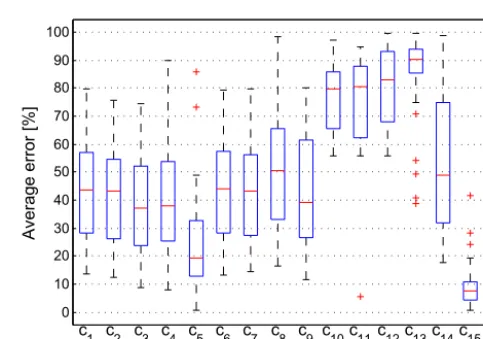
Figure 5 shows the segmentation error for all the 16 color channels. We observe that the saturation color channel (c5) and the ratio color channel (c15) has better performance as compared to other color channels. Therefore, we choose the
c15=(B−R)/(B+R) channel as the optimum color channel for HDR segmentation and in subsequent experiments. The
c15color channel performs the best, owing to a physical phe-nomenon called Rayleigh scattering: small particles in the atmosphere scatter light at varying degree. The blue com-ponent (lowest wavelength) gets scattered the most, which renders a bluish color to the sky. Thec15color channel is the normalized ratio of red and blue color channels and is the most discriminatory feature for cloud detection.
4.2.2 Seeding level sensitivity
As described in Sect. 3.2, the value of α determines the amount of initial seeds in HDRCloudSeg. We set a high value ofα, because it corresponds to higher confidence in assign-ing the correct labels. A higher confidence ensures low error
0 10 20 30 40 50 60 70 80 90 100
c1 c2 c3 c4 c5 c6 c7 c8 c9 c10c11c12c13c14c15c16
Color channel
Average error [%]
Figure 5.Distribution of the average segmentation error for differ-ent color channels of the HDR radiance map, across all the images of the HDR dataset. Within each box, the red line indicates the me-dian, and the bottom and top edges indicate the 25th and 75th per-centiles, respectively.
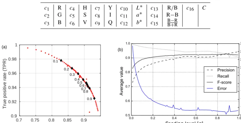
and high accuracy. We show the receiver operating charac-teristics (ROC) curve of our proposed algorithm for varying values of the seeding parameter. The ROC curve in Fig. 6a plots the false positive rate (=FPFP+TN) against the true positive rate (=TPTP+FN). We generate these points for varying values ofαin the interval[0,1]. This curve helps the user to select the best value of the seeding parameter. In order to illustrate its effect on the segmentation performance, we also evalu-ate the dependency of the seeding parameter on the various evaluation metrics.
ac-0.7 0.75 0.8 0.85 0.9 False positive rate (FPR) 0.9
0.92 0.94 0.96
True positive rate (TPR)
0.2 0.3
0.4 0.5
0.6 0.7
0.8
0.9
0.0 0.2 0.4 0.6 0.8 1.0
Seeding level [ α]
0.5 0.6 0.7 0.8
Average value
Precision Recall F-score Error
8 10 12 14 16 18 20
Average error [%]
Figure 6. (a)Impact of the seeding parameter on receiver operating characteristics (ROC) curve; the black diamonds indicate the intermediate ROC points, for seeding parameter in intervals of 0.1 in the range [0,1].(b)Impact of the seeding parameter on average precision, recall, F-score value and error.
curate detection of labels. Similar observations apply to av-erage precision, recall and F-score.
The sensitivity of the seeding parameter can also help us in understanding different types of clouds around the sun au-reole. In this paper, we deal only with the detection of thick clouds in the circumsolar region. Primarily this is because classifying the type of clouds into thick or thin clouds is an extremely difficult task in the area around the sun. Most of circumsolar region pixels are close to saturation. However, the seeding parameterαhas a control on the type of detected clouds. For example, we can detect thin clouds by tuning the seeding parameter to favor higher cloud detection (i.e., more tendency to classify a pixel as cloud), but this comes at the expense of reduced precision.
From Fig. 6b, we observe that there is a dip in the error at
α=0.88. Moreover, at this value, there is a good trade-off between precision and recall values – both are high. There-fore, we set the value of the seeding parameterαto 0.88 in the subsequent experiments. We also observe that there are a few deviation points along the curve. The minor peaks and troughs in Fig. 6 are due to the sensitivity of the considered seeding level. This occasionally causes errors in the seed-ing accuracy, which subsequently impacts the final evalua-tion metric of cloud detecevalua-tion.
4.2.3 Segmentation performance
Since existing cloud segmentation algorithms are designed for conventional LDR images, we evaluate them on the mid-exposure LDR images as well as the tone-mapped HDR im-ages. Our proposed HDRCloudSeg algorithm is the only one
designed to make use of the full HDR radiance maps. How-ever, for the sake of comparison, we also evaluate it for mid-exposure LDR and tone-mapped images. The detailed eval-uation results of HDRCloudSeg, along with the other cloud segmentation methods, are shown in Table 2.
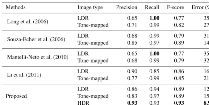
From Table 2, we observe that HDR imaging improves the cloud segmentation performance irrespective of the method used. We observe that most of the benchmark algorithms (ex-cept for Li et al., 2011) have a better performance with tone-mapped HDR images as compared to the mid-exposure LDR image. This is because a tone-mapped version exhibits fewer saturated pixels and clearer contrast between sky and cloud as compared to the corresponding LDR image. However, our proposed method HDRCloudSeg using the entire HDR radi-ance map achieves the lowest error of 8.91 % across all the methods.
Most of the other algorithms are biased towards a higher recall value (tendency to overestimate cloud cover) with lower precision. These existing algorithms are based on a set of thresholds, either fixed or adaptive, and are therefore more prone to high error percentage. However, HDRCloud-Seg uses the entire DR of sky–cloud scenes to make a more informed decision in classifying a pixel as cloud or sky.
5 Conclusions and future work
Mantelli-Neto et al. (2010) LDR 0.65 1.00 0.77 35.2
Tone-mapped 0.68 0.99 0.79 32.1
Li et al. (2011) LDR 0.90 0.85 0.86 16.2
Tone-mapped 0.77 0.99 0.85 21.8
Proposed
LDR 0.86 0.94 0.89 12.8
Tone-mapped 0.83 0.97 0.89 15.0
HDR 0.93 0.93 0.93 8.91
significantly more detail than traditional LDR images, espe-cially in the circumsolar region and near the horizon. We have shown that this method outperforms others. Our pro-posed methodology is reliable, efficient and easy to deploy.
In our future work, we plan to investigate how HDRI im-proves the accuracy of other tasks, such as cloud classifica-tion (Dev et al., 2015a) or cloud height estimaclassifica-tion (Savoy et al., 2015). In order to improve benchmarking, we will also work on expanding the sky–cloud HDR dataset introduced here with more images and distinctions between cloud types.
Code and data availability. In the spirit of reproducible research (Vandewalle et al., 2009), we release the entire HDR sky–cloud image dataset as well as the source code of all simulations in this paper. The SHWIMSEG database is available at http: //vintage.winklerbros.net/shwimseg.html (Dev et al., 2018a); the MATLAB code of HDRCloudSeg is available at https://github.com/ Soumyabrata/HDR-cloud-segmentation (Dev et al., 2018b).
Competing interests. The authors declare that they have no conflict of interest.
Acknowledgements. This research is funded by the Defence Science and Technology Agency (DSTA), Singapore.
Edited by: Szymon Malinowski Reviewed by: three anonymous referees
References
Akyüz, A. O.: High dynamic range imaging pipeline on the GPU, J. Real-Time Image Process., 10, 273–287, https://doi.org/10.1007/s11554-012-0270-9, 2015.
Bagon, S.: Matlab wrapper for graph cut, available at: http://www. wisdom.weizmann.ac.il/~bagon (last access: April 2017), 2006. Boykov, Y. and Jolly, M.-P.: Interactive graph cuts for optimal
boundary & region segmentation of objects in N-D images, in: Proc. International Conference on Computer Vision (ICCV), https://doi.org/10.1109/ICCV.2001.937505, 2001.
Boykov, Y. and Kolmogorov, V.: An experimental compari-son of min-cut/max-flow algorithms for energy minimiza-tion in vision, IEEE T. Pattern. Anal., 26, 1124–1137, https://doi.org/10.1109/TPAMI.2004.60, 2004.
Boykov, Y., Veksler, O., and Zabih, R.: Fast approximate energy minimization via graph cuts, IEEE T. Pattern. Anal., 23, 1222– 1239, https://doi.org/10.1109/34.969114, 2001.
Debevec, P. E. and Malik, J.: Recovering high dynamic range ra-diance maps from photographs, in: Proc. 24th Annual Con-ference on Computer Graphics and Interactive Techniques, https://doi.org/10.1145/258734.258884, 1997.
Dev, S., Lee, Y. H., and Winkler, S.: Systematic study of color spaces and components for the segmentation of sky/cloud im-ages, in: Proc. International Conference on Image Processing (ICIP), 5102–5106, https://doi.org/10.1109/ICIP.2014.7026033, 2014a.
Dev, S., Savoy, F. M., Lee, Y. H., and Winkler, S.: WAHRSIS: A low-cost, high-resolution whole sky imager with near-infrared capabilities, in: Proc. IS&T/SPIE Infrared Imaging Systems, https://doi.org/10.1117/12.2052982, 2014b.
Dev, S., Lee, Y. H., and Winkler, S.: Categorization of cloud im-age patches using an improved texton-based approach, in: Proc. International Conference on Image Processing (ICIP), 422–426, https://doi.org/10.1109/ICIP.2015.7350833, 2015a.
Dev, S., Savoy, F. M., Lee, Y. H., and Winkler, S.: Design of low-cost, compact and weather-proof whole sky imagers for High-Dynamic-Range captures, in: Proc. International Geo-science and Remote Sensing Symposium (IGARSS), 5359– 5362, https://doi.org/10.1109/IGARSS.2015.7327046, 2015b. Dev, S., Savoy, F. M., Lee, Y. H., and Winkler, S.:
github.com/Soumyabrata/HDR-cloud-segmentation, last access: 5 April 2018b.
Fua, C.-L. and Cheng, H.-Y.: Predicting solar irradiance with all-sky image features via regression, Sol. Ener., 97, 537–550, https://doi.org/10.1016/j.solener.2013.09.016, 2013.
Gryaditskya, Y., Pouli, T., Reinhard, E., and Seidel, H.-P.: Sky based light metering for high dynamic range images, Comput. Graph. Forum, 33, 61–69, https://doi.org/10.1111/cgf.12474, 2014. IPCC: Climate Change 2013: The Physical Science Basis, Tech.
rep., Intergovernmental Panel on Climate Change (IPCC), 2013. Kenny, P., Olley, J. A., and Lewis, J. O.: Whole-sky luminance maps from calibrated digital photography, in: Proc. EuroSun Confer-ence, 2006.
Kleissl, J., Urquhart, B., Ghonima, M., Dahlin, E., Nguyen, A., Kurtz, B., Chow, C. W., and Mejia, F. A.: University of Califor-nia, San Diego (UCSD) Sky Imager Cloud Position Study Field Campaign Report, Tech. rep., DOE ARM Climate Research Fa-cility, Washington, DC (United States), 2016.
Kolmogorov, V. and Zabin, R.: What energy functions can be min-imized via graph cuts?, IEEE T. Pattern. Anal., 26, 147–159, https://doi.org/10.1109/TPAMI.2004.1262177, 2004.
Li, Q., Lu, W., and Yang, J.: A hybrid thresholding algorithm for cloud detection on ground-based color images, J. Atmos. Ocean. Technol., 28, 1286–1296, https://doi.org/10.1175/JTECH-D-11-00009.1, 2011.
Liu, S., Zhang, L., Zhang, Z., Wang, C., and Xiao, B.: Auto-matic cloud detection for all-sky images using superpixel seg-mentation, IEEE Geosci. Remote Sens. Lett., 12, 354–358, https://doi.org/10.1109/LGRS.2014.2341291, 2015a.
Liu, S., Zhang, Z., Xiao, B., and Cao, X.: Ground-based cloud detection using automatic graph cut, IEEE Geosci. Remote Sens. Lett., 12, 1342–1346, https://doi.org/10.1109/LGRS.2015.2399857, 2015b.
Long, C. N., Slater, D. W., and Tooman, T.: Total Sky Imager model 880 status and testing results, Tech. rep., DOE Office of Science Atmospheric Radiation Measurement (ARM) Program (United States), 2001.
Long, C. N., Sabburg, J. M., Calbó, J., and Pages, D.: Re-trieving cloud characteristics from ground-based daytime color all-sky images, J. Atmos. Ocean. Technol., 23, 633–652, https://doi.org/10.1175/JTECH1875.1, 2006.
Mantelli-Neto, S. L., von Wangenheim, A., Pereira, E. B., and Comunello, E.: The use of Euclidean geometric dis-tance on RGB color space for the classification of sky and cloud patterns, J. Atmos. Ocean. Technol., 27, 1504–1517, https://doi.org/10.1175/2010JTECHA1353.1, 2010.
Richter, T.: On the standardization of the JPEG XT image com-pression, in: Proc. Picture Coding Symposium (PCS), 37–40, https://doi.org/10.1109/PCS.2013.6737677, 2013.
Savoy, F. M., Lemaitre, J., Dev, S., Lee, Y. H., and Winkler, S.: Cloud base height estimation using high-resolution whole sky imagers, in: Proc. International Geoscience and Remote Sensing Symposium (IGARSS), 1622–1625, https://doi.org/10.1109/IGARSS.2015.7326095, 2015.
Schumann, U., Hempel, R., Flentje, H., Garhammer, M., Graf, K., Kox, S., Lösslein, H., and Mayer, B.: Contrail study with ground-based cameras, Atmos. Meas. Tech., 6, 3597–3612, https://doi.org/10.5194/amt-6-3597-2013, 2013.
Souza-Echer, M. P., Pereira, E. B., Bins, L. S., and An-drade, M. A. R.: A simple method for the assessment of the cloud cover state in high-latitude regions by a ground-based digital camera, J. Atmos. Ocean. Technol., 23, 437–447, https://doi.org/10.1175/JTECH1833.1, 2006.
Stephens, G. L., Li, J., Wild, M., Clayson, C. A., Loeb, N., Kato, S., Lecuyer, T., Jr, P. W. S., Lebsock, M., and An-drews, T.: An update on Earth’s energy balance in light of the latest global observations, Nat. Geosci., 5, 691–696, https://doi.org/10.1038/ngeo1580, 2012.
Stumpfel, J., Tchou, C., Jones, A., Hawkins, T., Wenger, A., and Debevec, P.: Direct HDR capture of the sun and sky, in: Proc. 3rd International Conference on Computer Graph-ics, Virtual Reality, Visualisation and Interaction in Africa, https://doi.org/10.1145/1185657.1185687, 2004.
Vandewalle, P., Kovacevic, J., and Vetterli, M.: Reproducible re-search in signal processing, IEEE Signal Processing Magazine, 26, 37–47, https://doi.org/10.1109/MSP.2009.932122, 2009. Yuan, F., Lee, Y. H., and Meng, Y. S.: Comparison of
radio-sounding profiles for cloud attenuation analy-sis in the tropical region, in: Proc. IEEE International Symposium on Antennas and Propagation, 259–260, https://doi.org/10.1109/APS.2014.6904461, 2014.