i
LOCALIZATION TECHNIQUE BASED ON TIME DIFFERENCE OF ARRIVAL FOR TRACKING APPLICATION IN WIRELESS SENSOR NETWORKS
NUR HIDAYU BINTI SALLEH
This report is submitted in partial fulfilment of requirement for Bachelor of Electronics Engineering (Telecommunication Electronics)
Faculty of Electronics and Computer Engineering Universiti Teknikal Malaysia Melaka
ii
UNIVERSTI TEKNIKAL MALAYSIA MELAKA
FAKULTI KEJURUTERAAN ELEKTRONIK DAN KEJURUTERAAN KOMPUTER
BORANG PENGESAHAN STATUS LAPORAN PROJEK SARJANA MUDA II
Tajuk Projek :
Sesi Pengajian :
1. 1
Saya ……….. (HURUF BESAR)
mengaku membenarkan Laporan Projek Sarjana Muda ini disimpan di Perpustakaan dengan syarat-syarat kegunaan seperti berikut:
1. Laporan adalah hakmilik Universiti Teknikal Malaysia Melaka.
2. Perpustakaan dibenarkan membuat salinan untuk tujuan pengajian sahaja.
3. Perpustakaan dibenarkan membuat salinan laporan ini sebagai bahan pertukaran antara institusi pengajian tinggi.
1. 2SILA TANDAKAN ( √ ) :
SULIT* *(Mengandungi maklumat yang berdarjah keselamatan atau kepentingan Malaysia seperti yang termaktub di dalam AKTA RAHSIA RASMI 1972)
TERHAD** **(Mengandungi maklumat terhad yang telah ditentukan oleh organisasi/badan di mana penyelidikan dijalankan)
TIDAK TERHAD
LOCALIZATION TECHNIQUE BASED ON TIME DIFFERENCE OF ARRIVAL FOR TRACKING APPLICATION IN WIRELESS SENSOR NETWORKS
LOCALIZATION TECHNIQUE BASED ON TIME DIFFERENCE OF ARRIVAL FOR TRACKINGAPPLICATION IN WIRELESS SENSOR NETWORKS
NUR HIDAYU BINTI SALLEH
iii
iv
“I acknowledge that I have read this report and in my opinion this report is sufficient in terms of scope and quality for the award of Bachelor of Electronics Engineering
v
By the name of Allah the Most Gracious, Most Merciful
vi
ACKNOWLEDGEMENT
First and foremost, I am grateful and thanks to Allah S.W.T for blessing me with a good health in completing this project. I also would like to express my greatest gratitude to most dedicated and supportive supervisor, Madam Zahariah binti Manap for providing her insightful knowledge and valuable assistance throughout the completion and successfully of this project under her guidance.
A special note of appreciation is extended to my family especially my parents, for their unfailing encouragement and financial support that they have given to me over the years. Their support and encouragement is one of the main causes of the success I gain today.
Thanks also to all my friends for their guidance and knowledge they provide to me. My thanks also go to all who support me directly and indirectly in completing this project.
Lastly, I am grateful and thanks to my true self for not giving up while completing the whole journey since the challenge is real.
vii
ABSTRACT
viii
ABSTRAK
Rangkaian penderia tanpa wayar (WSNs) terdiri daripada kuasa besar yang rendah, kos rendah dan nod penderia yang berkeupayaan rendah. WSNs boleh digunakan dalam pelbagai aplikasi seperti pengesanan acara, pengesanan sasaran, pemantauan alam sekitar dan banguna pintar. Dalam aplikasi mengesan trek, sasaran boleh dianggarkan menggunakan teknik multilateration berdasarkan lokasi nod penderia dan
ix
LIST OF TABLES
Table 3.1: Simulation parameters 19
Table 4.1: Total of RMSE for different number of sensor nodes deployed for both
algorithms 31
Table 4.2: Average RMSE for different number of sensor nodes deployed for both
algorithms 31
x
LIST OF FIGURES
Figure 2.1: Sensor node architecture 6
Figure 2.2: Tracking protocol in WSNs 7
Figure 2.3: Overview of localization 9
Figure 2.4: Geometry of Hyperbola 10
Figure 2.5: Intersection of three hyperbolas 12
Figure 3.1: Deployment of the different number of sensors, N where (a) N=100, (b)
N=200, (c) N=300, (d) N=400 and (e) N=500 21
Figure 3.2: Tabulation data after simulation 22
Figure 4.1: Static Target Localization using LLS method 24 Figure 4.2: Static Target Localization using TDOA partial derivatives method 24 Figure 4.3: Mobile Target Tracking using LLS method 25 Figure 4.4: Mobile Target Tracking using TDOA partial derivatives method 25
Figure 4.5: RMSE for both algorithms 26
Figure 4.6: Tracking path for both algorithms when N=200 27 Figure 4.7: Graph of RMSE for both algorithms at t=1s until t=35s when N=200 28 Figure 4.8: Tracking path for both algorithms when N=300 28 Figure 4.9: Graph of RMSE for both algorithms at t=1s until t=35s when N=300 29 Figure 4.10: Tracking path for both algorithms when N=400 29 Figure 4.11: Graph of RMSE for both algorithms at t=1s until t=35s when N=400 30 Figure 4.12: Tracking path for both algorithms when N=500 30 Figure 4.13: Graph of RMSE for both algorithms at t=1s until t=35s when N=500 31 Figure 4.14: Graph of total RMSE for both algorithms at different number of sensor
nodes deployed 32
Figure 4.15: Graph of average RMSE for both algorithms at differences number of
sensor nodes deployed 32
Figure 4.16: Mobile Target Tracking of TDOA Partial Derivatives method when
N=25 33
Figure 4.17: Mobile Target Tracking of TDOA Partial Derivatives method when
xi
Figure 4.18: Graph of average RMSE for N=25 and N=50 34 Figure 4.19: Graph of total RMSE for both algorithms at different number of
Gaussian noise variance 35
Figure 4.20: Graph of average RMSE for both algorithms at different number of
xii
LIST OF APPENDIX
xiii
TABLE OF CONTENTS
PROJECT TITLE i
FYP STATUS VERIFICATION FORM ii
STUDENT DECLARATION iii
SUPERVISOR DECLARATION iv
DEDICATION v
ACKNOWLEDGEMENT vi
ABSTRACT vii
ABSTRAK viii
LIST OF TABLES ix
LIST OF FIGURES x
LIST OF APPENDIX xii
TABLE OF CONTENTS xiii
CHAPTER 1 1
INTRODUCTION 1
1.1 Introduction 1
1.2 Objectives 2
1.3 Problem statement 2
1.4 Scope of works 3
1.5 Report Structure 4
CHAPTER 2 5
LITERATUREREVIEW 5
2.1 Introduction to Wireless Sensor Networks 5 2.2 Tracking Application in Wireless Sensor Networks 7
2.3 Localization Techniques 8
xiv
2.5 Localization Technique based on TDOA 11
2.6 Linear Least Square Method 13
2.7 Root Mean Square Error 14
2.8 Related Works 15
2.9 MATLAB Software 16
CHAPTER 3 18
METHODOLOGY 18
3.1 Introduction 18
3.2 TDOA-based Algorithm Development 18
3.3 Evaluation of the Algorithm Performances 21
3.4 Data Tabulation 22
3.5 Graph Plotting 22
CHAPTER 4 23
RESULTSANDDISCUSSION 23
4.1 Static Target Location Estimation 23
4.2 Mobile Target Tracking 24
4.3 Performances Analysis 26
4.3.1 The Effect of Number of Sensor Nodes 26
4.3.2 The Effect of Noise Variance 34
CHAPTER 5 36
CONCLUSIONANDFUTUREWORKS 36
5.1 Conclusion 36
5.2 Future Works 37
REFERENCES 38
1
CHAPTER 1
INTRODUCTION
1.
1.1Introduction
A wireless sensor network (WSN) is self-configuring wireless sensor devices that are spatially distributed in diverse location. Each sensor node can independently perform some processing and sensing task and communicate to each other in order to forward the sensing information to the central computer. It typically has several parts such as transducer, microcomputer, and transceiver and power source.
The electrical signal is generated by the transducer if it senses the phenomenon of interest. The processing and the storing of the output are done by the microcomputer. The transceiver will receive command from a central computer thus it will transmit the data to it. Each sensor node get power derived from the battery.
WSN have a broad range of application such as environmental monitoring, healthcare application, emergency rescue, surveillance system and target tracking [1]. While the sensor networks are promising in solving many problems, one of the fundamental challenges that still exits is target localization [2]. Recent advanced in wireless sensor networks have led to renewed interest in target localization and thus becoming a hot topic amongst the researcher[3].
2
During the last decade, a number of positioning algorithms have been proposed for the positioning problem [4].
There are numerous localization techniques that widely used like the ones which are based on Received Signal Strength Indicator (RSSI), Angle of Arrival (AOA), Time of Arrival (TOA) and Time Difference of Arrival (TDOA). To encounter the challenges in WSNs, we decided to use the most prominent fundamental and popular method which is TDOA in order to locate the chosen target.
1.2Objectives
This project aims to estimate the location of the target in WSN. To achieve this aim, three objectives have been listed as follows:
1. To develop a target localization algorithm in WSN based on TDOA.
2. To increase the accuracy of target localization while estimate the position of an event occurs as accurately as possible by means of changing the location and number of sensor.
3. To evaluate the performance of localization algorithm based on root mean square error (RMSE).
1.3Problem statement
Localization is one of the most prominent challenges in WSN. Since most of WSN applications depend on accurate location estimation, a straightforward solution is to equip each sensor with Global Positioning System (GPS) receiver that can accurately provide the sensor with their exact location [5]. However, it is not a feasible solution since GPS cannot be implemented if there are obstacles that might block the line of sight of the signal transmit between the receiver and satellite such as mountains or buildings.
3
Since one of the sensor node requirement is need to be small, directly embedding the GPS device would enlarge the size of sensor due to size of GPS and its antenna. Sensor nodes have a longer lifespan and known to be deployed without replacing any sort of battery for many years. However, GPS receiver is not energy efficient. In consequence, it can drain the sensor node battery very fast and reduces the effective lifetime of the networks.
Even though there are many existing techniques have been introduces, yet the measurement estimation still can be affected due to the nature of wireless signal propagation such as multipath fading that can cause uncertainty in estimated target location. The received signal also can be influenced by the random noise produced by the signal itself since the sensor is moving in random pattern. Moreover, the distance measurement noise and Gaussian White Noise also contribute in the signal propagation loss. All of them might cause some delay in time of arrival of the signal that lead to the inaccurate value for the next computation in order to estimate the location of real target.
1.4Scope of works
According to whether or not the networks need to measure the actual distances between network nodes and based on whether accurate ranging is required, Wireless Sensor Networks can be divided into two categories which are Range-Based technique and Range-Free technique [6]. In this work, Range-Based technique has been chosen and mainly this work focus on Time of Arrival (TOA) and Time difference of Arrival (TDOA) to estimate the sensor node position. There are some basic assumptions have been made in order to accomplish the goals:
i. The coordinate of the sensor nodes is known.
ii. The location of the target is unknown and to be estimated. iii. All sensors are synchronized with respect to time.
iv. Only one target at one time.
4
1.5Report Structure
5
CHAPTER 2
LITERATURE REVIEW
2.
2.1Introduction to Wireless Sensor Networks
A WSN refers to a group of distinctive transducer with a communication basis for monitoring and recording the physical condition at the specified area or network field. Nowadays, they have gain a world-wide attention due to the enormous potential in many applications. Briefly examine their history, WSNs had been widely implemented in military and heavy industrial application. In 1950s, the United Stated Military successfully developed Sound Surveillance System (SOSUS) which the first wireless network that resembles the modern WSNs to detect and track the Soviet submarines[7]. This network used hydrophone acoustic sensor submerged and distributed in the Atlantic and Pacific Oceans.
Later, the market demand for the WSNs become so strong and they moved beyond their limited application and it is seems to be a great challenge. To meet this demand, a lot of changes have been introduces over the years resulting in robustness, better efficiency and low cost devices that have an ability to store and process data with a superb effectiveness and reduces power intake.
6
Figure 2.1: Sensor node architecture
The function of the processor is to plan and carry out the task, process the data information’s and control the other components in sensor nodes. There are several processors that available for the sensor nodes such as Microcontroller, Digital signal processing (DSP), Field Programmable Gate Array (FPGA) and Application Specific integrated Circuit (ASIC). Since a microcontroller is characterized by its low price, ease to attach other devices, simplicity in programming, they are used in sensor nodes[8] [9].
Microcontroller contains embedded memory that sufficient to store the project. When the sensor measures the information, it depends on the application necessities and outside elements number of information gathered by sensor varies. Presently from the information gathered need to put away and cast only the vital information must be sent to the base station or cluster heads. The transceiver is a combination of a transmitter and receiver. Transceiver responsible to sends and receives message wirelessly. There are many types of wireless transmission media like Radio frequency (RF), Laser and Infrared.
7
2.2 Tracking Application in Wireless Sensor Networks
In tracking application, there are two types of mode available for the sensor nodes which are active mode and inactive mode. Active mode is when the sensor nodes can sense the target at the certain period while when the sensor nodes in sleep state which means they are saving their energy until the target approach them called as inactive mode [11]. As the target moving, the sensor must continuously in active mode.
[image:21.595.192.466.312.416.2]So, there are some standard of tracking protocol that had been used in WSNs. To summarize, the Figure 2.2 shows the types of tracking protocol that can be used to estimate the location of mobile target.
Figure 2.2: Tracking protocol in WSNs
In tree based protocol, the nodes are orderly arranged in hierarchical tree structure. When the tracking takes place, the sensor nodes will communicate with each other to determine the root node. Usually, the root node is a node that happen to be near with the target. Even though, the accuracy of this protocol is higher but it is resulting higher energy consumption.
Due to this fact, when the new node is added, the old ones will be removed to reduce some energy consumption [12]. There are some example of the tree based tracking which are Dynamic Object Tracking (DOT), Scalable Tracking Using Network sensors (STUN), Dynamic Convoy Tree Based Collaboration (DCTC) and Deviation Avoidance Tree (DAT).
8
clustering where the sensor will volunteer to function as the cluster head when it detects any target movement.
For static cluster, they faces a boundary problem which block them in sharing information with other group of static clustering whereas in dynamic clustering is high energy consumption since there is repeating of clustering process although it is efficient way to locate the target tracking[13]. Prediction Based or Proactive Clustering and Non Prediction Based Clustering is division of Static clustering and Dynamic Clustering consist of Information Driven Sensor Querying (IDSQ), DELTA and RARE.
Hybrid based protocol is a combination of one or more type of target tracking algorithms, for example the Dynamic Clustering for Acoustic Tracking (DCAT) and Hierarchical prediction strategy (HPS). HPS is formed using the Voronoi division and Least Square Method to estimate the next target location. In DCAT, Voronoi Diagram functions to form the cluster. If the cluster head detects the higher signal strength which exceed the pre-determined threshold, one active cluster head is formed.
Then, it will send a broadcast packet to request the neighbour sensor to join the cluster. The sensor can make the choice whether to accept or reject the request based on the distance estimation between target and themselves. Lastly, cluster head will carry out the localization method to estimate the target location based on the sensor replies before send the final result to sink[14].
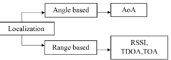
2.3Localization Techniques
9
Figure 2.3: Overview of localization
Of the several methods, AOA is a method that operates based on the angle between the propagation direction of incident waves and some reference direction. Firstly, an array of sensors and signal processing technique are employed to estimate the angle between the sensor nodes and the target. Secondly, the approach is followed by doing hybrid combination between RSSI and AOA to obtain the result with higher accuracy but unfortunately AOA is suffering from limitation due to multiple antennas requirement thus increase the cost of limitation.
Then, RSSI is an indicator used at the sensor nodes to determine the strength of received signal. RSSI technique depends on the angle of measurement and noise of environment cause hard to acquire an accurate position. They implementation of this method can be classified into two types which are range-free and range based technique.
If they used the connectivity of data to get the information about target positioning without acknowledge the distance to the target, it is range-free method. On the other hand, if it is only depends on the nodes to estimates the position of the target thus acknowledge the distance to the target, it is range-based method [16]. As advantages, this method has lower accuracy especially for the indoor environment especially in the region near the walls.
10
TDOA is very similar to TOA in order to measure the distance, it uses the travel time between transmitter and receiver besides using travel time between each sensor to locate the event occurs. In this project, we decided to use the TDOA based on the previous literature study in choosing the best technique to locate the estimate position of an event occurs and widely been used in navigation and positioning system[18].
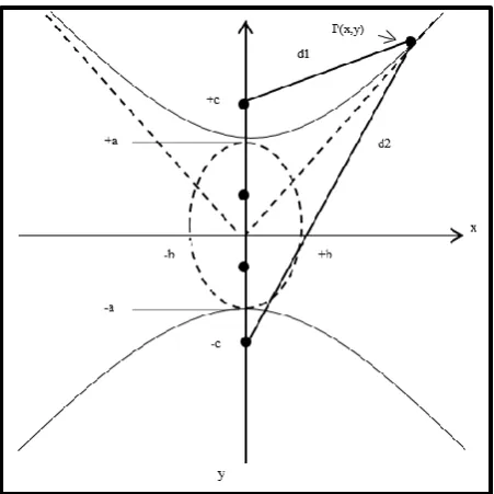
2.4Fundamental of Hyperbola
[image:24.595.215.441.314.540.2]To get a better clarification, we need to know the basis fundamental of hyperbola. Based on the Figure 1, let’s consider a hyperbola with the transverse axis aligned with the characteristic equation as in (1)-(3).
Figure 2.4: Geometry of Hyperbola
𝑦2
𝑎2−
𝑥2
𝑏2 = 1 (1)
𝑎2 + 𝑏2 = 𝑐2 (2)
|𝑑2− 𝑑1| = 2𝑎 (3)
where:
𝑎: The distance from either vertex to the centre
𝑏: The length of the perpendicular segment between each vertex and the
asymptotes