© 2015, IRJET.NET- All Rights Reserved
Page 36
A CASE STUDY OF WATER SHED DEVEPLMENT IN DAREWADI
Dr. M. Husain*
1F. I.Chavan
2, SantoshSanap
3*1
Professor,
2Associate Professor,
3PG Research Scholar, Department of civil engineering,
SSBT College of Engineering, Bambori, North Maharashtra University, India
---Abstract
-
The problem of water is not only
arrived now-a- days but it is arising since
thousands of years. ago such the man started
thinking on the problem of inadequate water and
its proper use from the time he started fanning
and henceforth this problem is going to arise in
one or the other way and it is the challenge
before the people to solve the problem of
inadequate water arising in their decade no one
can say that whether this problem will be solved
or not in ten years or hundred years) "Many a
Little Manes a Mickle "each and every drop of
water is very necessary but, its management is
not proper. At some places implementation of
sprinkler and drip irrigation is done but. That
water cannot be used for wider areas due to
unevenness of rainfall in different regions. The
crops are destroying is commonly heart it is
taking a step forward to save drop and to use it in
extreme conditions. Environmental regeneration
is possible only when the concerned people see a
reason for it and are fully in control of all aspects
of resource mobilization, management and
conservation just as human being and their
activities
are
the
primary
causes
of
environmental destruction, and they are the
reassures for restarting the health of the
environment that they are rained. Hence there
can be no sustainable natural resources
management without the active participation of
all inhabitants of the concerned environment. So
considering above factors we should take a step
forward for proper management and letter use of
available water
.
Key
Words:
watershed
development,
rural
development, land use, catchment stabilization,
human effort etc
1 INTRODUCTION
© 2015, IRJET.NET- All Rights Reserved
Page 37
as part-time laborers in other people's fields they or migrate to make both ends meet marginal farmers also migrate to the nearby villages or towns during the lean season. The village had a total livestock population of 1717 before 1997 and it consisted mainly of sheep goats bullocks indigenous breeds of cows and a few horses livestock farming was only of marginal significance as there were only 14 crossbred cows in the village the number of livestock has been reduced to 380 in the year 2000 as most of the sheep and unproductive cattle are disposed of. Darewadi-Shelkewadi line the rain shadow region of the Sahyadri range and is considered to be one of the backward village in this region over the years the environment has been heavily degraded due to the irrational exploitation of natural resources and this has given rise to problems of scarcity of fodder and bio-mass availability soil erosion and excessive run-off of water. The lack of soil and water conservation measures resulted in the decline of agricultural productivity non-viability of large or improved herd holding and migration of world force to nearby towns and cities.
2 HISTORY OF DAREWADI
Five generation ago the first group of people settled in Darewadi at that time the place used to be surrounded by thick forest and many Nallas so the people started farming and kept lots of sheep since they belonged to the Vanjari- and dhangar communities milk was always available in the villages slowly relatives and friends joined the first family and also other families started settling in Shelkewadi. Even 50 years ago the village was still surrounded by this thick forest but due to some severe drought years and less work in the agricultural fields we had to cut the trees for making charcoal which was sold in sangamner this was the only source of income we still could get within the village or we had to opt for migration as adivasis we were well aware of the importance of trees but there was no other option in the end two things
happened (a) the natural resources diminished and (b) the people immigrated the people migrated the people permanently immigrated to Bombay and surat as well as seasonally to sugar cane factories brick kilns and other places where labor was in demand. We were always used to agricultural income from the crop yields as well as income from huge herds of sheep and goats grazing in the village boundaries Our village got electricity in 1970 and some employment guarantee schemes in the year of the severe drought in 1972 so we constructed Nallas bunds and percolation tanks and could find work within the village
3.
WATERSHED TRAINING CENTRE
WOTR has set up a Watershed Training Centre in Darewadi as this village offers an ideal location for conducting trainings, giving the trainees firsthand experience of the field and its people, thus fostering understanding and learning of the various aspects of watershed development.
WOTR conducts trainings for various levels of staff (policy and decision-makers, middle management as well as implementing staff) of government organizations, donors and NGOs as well as for village communities. Darewadi, which was once a remote and isolated village, is now a web of activity. Visitors come from far off places to understand and share their success story and many of them go back with the resolve to replicate this effort in their own areas.
The villagers themselves explain to the visitors and some of the VWC and women's group members even as resource persons for creating awareness in other villages. Due to the 'demonstration effect' of Darewadi
© 2015, IRJET.NET- All Rights Reserved
Page 38
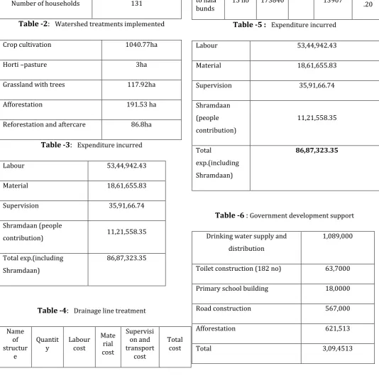
Table -1
: Information of Darewadi watershed
Total area of watershed 1535.24 ha
Forest land 306.53 ha
Revenue land 147.69 ha
Private land 1063.43ha
Number of households 131
Table -2
:
Watershed treatments implementedCrop cultivation 1040.77ha
Horti –pasture 3ha
Grassland with trees 117.92ha
Afforestation 191.53 ha
Reforestation and aftercare 86.8ha
Table -3
:
Expenditure incurredLabour 53,44,942.43
Material 18,61,655.83
Supervision 35,91,66.74
Shramdaan (people
contribution) 11,21,558.35 Total exp.(including
Table -5 :
Expenditure incurredLabour 53,44,942.43
Table -6
:
Government development supportDrinking water supply and distribution
1,089,000
Toilet construction (182 no) 63,7000 Primary school building 18,0000
Road construction 567,000
Afforestation 621,513
© 2015, IRJET.NET- All Rights Reserved
Page 39
3 DESIGN OF GULLY PLUG (GP)
Estimate to reduce high velocity of runoff
Assumeddimensions for stone plug based on actual survey
Length = 8.0m Height = 1.0m Top width =0.6m Bottom width=1.0m
Volume of stone requirid for one stone plug=8.40 I) Excavation : 8x1x0.15m=1.2cum
II) Total volume of stone required : 6.4+1.2=7.6cum
III) Amount required for construction : 7.6x17=129.2Rs
IV) Amount for earthwork : 1.2x20=24Rs Hence Total Amount required per stone plug of 8cm=129.2+24=153.20Rs
Fig -1 : Check dam longitudinal section
Fig-2 : Check dam plan
4.4 PROJECT MANAGEMENT COST. Sr.
No. Specifications Rate
Total Cost
1 WOTR Field staff and 0 & M of Motor Cycle
Community Organizer / Field
Officer 3000 144000
Agronomist/Agril.EnggiCivil
Engg. 4000 192000
2 Promotion and Training (for 4 years
Agriculture 10000 40000
Health 5000 20000
Veterinary 5000 20000
Forestry 8000 32000
Women Development 10000 40000 Youth Development 10000 40000 Tribal Development 3000 12000 Watershed Management Trg. 7000 28000 3 Project Management
a) Recurring Expenses
Project Manager 6000 288000
Office Clerk 2500 120000
Driver 1600 76800
Travel Cost of Staff. 2000 96000 0 & M. of vehicle 6000 288000 b) Office Expenses
Office Rent 500 24000
Watchman , Warden 300 14400
Postage 200 9600
Electric Bill 200 9600
Stationery 500 24000
Capital Expenses
Jeep 400000 400000
Motor Cycle 42000 42000
Survey Equipment 20000 20000
Cupboards 4000 4000
© 2015, IRJET.NET- All Rights Reserved
Page 40
Fig-3 : Check dam front view
Fig-4 : Check dam side view
5. CONCLUSION
The aim of this project is to emphasize the importance of the water conservation to overcome from shortage of water. The activities undertaken in this project include soil and water conservation measures like construction of Bandhara. We estimate the quantity of water about 0.74 TCM and work out the cost of construction about 9 lacks. By construction of Bandhara the stored water is use for agriculture purpose and to increase infiltration and to prevent soil erosion. Maharashtra has a large drought prone area (52%) and has faced recurrent
drought and famines (1907, 1911, 19181920, 1972, 2013 etc.) which generated attention on the improvement of agriculture in non-irrigated areas.This study period was too short to confirm effects of watershed management. However this study can be used as a baseline study for future evaluation.
1. The control of damaging runoff and degradation and thereby conservation of soil and water may achieve.
2. The infiltration of water may achieve.
3. The downstream area is protected by moderate floods can be possible.
4. Enhance the ground water recharge wherever applicable is to be possible.
5. Runoff water is managed and utilize for useful propose is to be possible.
6. Check for soil erosion and to reduce the effect of sediment yield on the watershed may possible.
REFERENCES
[1] Watershed Training Centre Darewadi
[2] Babu Suresh P., Muralidharan C, Venugopal K, “Watershed Runoff Estimation Using Remote Sensing and GIS Based SCS Method.” Proceedings of the International Conference on Hydrology and Watershed Management,2002 Dec 18 to 20, Vol-II, Editors B. Venketeshwara Rao, et. al, pp 447-455.
[3] Dutta Subashisa, Mishra A., Kar S., Panigrahy Sushma, “Estimating Spatial Curve Number for Hydrologic Response Analysis of a Small Watershed.” Journal of Spatial Hydrology, 2006, vol. 6, No. 2, pp57-67.
[4] Gupta K. K., Deelstra, et. al, “Estimation of water harvesting potential for a semiarid area using GIS and remote sensing.” Proceedings of Rabat Symposium S3, 1997,pp 53-62.