Abstract—In this paper, we consider the problem of occupancy grid map merging which is an important issue especially for multi-robot exploration task in search and rescue environments. We present scale invariant feature transform based methodology for combining individual partial map of robot units acquired from different parts of the mission environment. Proposed approach is designed not only for structured work areas, but also it is designed for unstructured and complex environment such as wide collapsed buildings. The proposed approach handles the limitations of existing works in the literature such as; first, merged robots’ maps not required being in the same scale, secondly little overlapped region area between partial maps is enough for good merging performance and finally unstructured partial environment maps can be merged efficiently. The simulation results support the potential of the proposed methodology for occupancy grid map merging task.
Index Terms—Multi-robot systems, occupancy grid map merging, scale invariant feature transform.
I. INTRODUCTION
Different kinds of catastrophe occur in the nature causing disaster areas such as collapsed buildings from earthquakes or hazardous environments where nuclear leakage exists. Search and rescue operations can be very harmful for human beings in these areas due to unstable structures and dangerous gas leakage which are general characteristics of disaster regions. So, in such cases, robots can assist humans during the search and rescue operations to reduce the probability of getting injured or death.
Robots as a rescuer encounter various challenging problems in search and rescue operations because of hard and dangerous environmental conditions. One of them is the localization of survivor among the rubbles and environment map generation to give information about the condition of the victims or disaster area; it is called as exploration. Exploration is a very critical task of autonomous mobile robot teams in order to maximize their knowledge about the structure of their work space. Many difficulties arise while the robot team explores the unknown environment such as
Manuscript received July 9, 2010. This work was supported in part by the Middle East Technical University under project BAP-2002KI120510.
S. Topal is with Department of Electrical and Electronics Engineering, Middle East Technical University, Ankara, 06531,Turkey (phone: +90-312-210-4590; e-mail: [email protected]).
Đ. Erkmen is with Department of Electrical and Electronics Engineering, Middle East Technical University, Ankara, 06531,Turkey (e-mail: [email protected]).
A.M. Erkmen is with Department of Electrical and Electronics Engineering, Middle East Technical University, Ankara, 06531,Turkey (e-mail: [email protected]).
simultaneously localizing and mapping, path planning using noisy measurements. Exploration, accurate robot location estimation and mission space map generation abilities are important research topics and so huge number of works exists in the literature about them [1], [2]. Especially for search and rescue operations in wide and completely unknown catastrophe environments, mapping which is the process of the incrementally extracting a map of surrounding is a very crucial job while robots navigating in the task environment autonomously. The usage of multi-robot systems is often suggested due to some advantages over single robot systems in the mapping tasks like energy and time efficiency [3], [4]. Although, efficiency of the system increases in the sense of time and energy due to the coordination and cooperation between robot units, robot teams also encounter many difficulties during the task execution. One of them is the integration of partial maps which are generated by robot team members operating different part of the same mission area into highly precise global environment map. Especially search and rescue operations in large catastrophe areas, robots enter the work space from separate regions and independently explore different parts of the environment to extract the model of surroundings and localize the victim. Relationships between individual maps are not known due to different initial position and orientation of robots, i.e., each robot’s reference frames for mapping are different. Map merging problem can be explained in these situations as to find relative transformation (translation, rotation and scaling) between robots’ local maps for fusing them.
The challenge of map merging is worked by many researchers when the robots starts exploration task from different parts of the environment and extract the map of surroundings independently with respect to their own reference frames [5]-[9]. Some of them are about feature based map merging problem [7], [8]. Although they have shown the success of feature based map merging methods for multi-robot systems, these approaches are not feasible for unstructured and complex work environments since feature extraction is very hard to carry out. Hence, some researchers have focused on occupancy grid mapping approach for environment modeling and merging partial robots’ maps [5], [6]. Occupancy grid maps decompose the high dimensional continuum mapping problem into a one dimensional mapping problem, where the occupancy of each grid cell is estimated independently. Occupancy of a grid is a numerical value representing the posterior probability of a grid cell being occupied. This provides a simple spatial representation of the environment.
So far, several map merging methods have been proposed for occupancy grid maps generated by autonomous robots
A Novel Map Merging Methodology for
Multi-Robot Systems
[5], [6], [9]. Carpin et al., [5] developed a probabilistic methodology to combine partial environment maps, in which iterative search in the space of possible rigid transformations were performed with the aim of maximizing overlapped region between robot maps using a similarity metric. This approach guaranteed to find the optimal solution when the number of iterations tends to infinite which is not suitable for real time and complex applications like search and rescue operations. In order to improve the efficiency of the proposed algorithm in the sense of time, Carpin [6] presented a new non-iterative and fast method using spectral information of maps. Hough transform is performed to detect the orientation of the maps and translation information is obtained from two signals which are the projections along the x and y axis of the two maps. Proposed approach is fast and accurate according to the previous iteration based method [5]. However, spectral information based technique has also some limitations. First, occupancy grid maps being merged have to be in the same size. Hence, heterogeneous multi-robot search and rescue robot teams cannot use this approach because of different partial map size. Second, in their proposed methodology, it is essential that two partial maps being merged have to exhibit a certain degree of overlapping region in order for successful map merging. Finally, operation environment has to be well structured which means that mapping area consist of only walls or corridors. So, these limitations make the proposed occupancy grid map merging methodologies in the literature unfeasible for unstructured and complex search and rescue areas like semi collapsed building.
In this work, we present a novel occupancy grid map merging method based on scale invariant feature transform. The main contribution of this work was threefold. First, proposed algorithm is capable of merging partial maps which have limited degree of overlapping regions. Second one is about the size of merged maps; partial maps being merged can be different size. Finally, our proposed map merging method works well and fast also in unstructured and complex environments.
The rest of this paper is organized as follows: Section II introduces the definition of map merging problem. Proposed approach is presented in Section III and experimental results are given in Section IV. Finally, Section V concludes the paper.
II. PROBLEM DESCRIPTION
In this section the occupancy grid map merging problem is defined. Imagine a search and rescue scenario in a complex and unknown disaster environment like semi-collapsed wide building occurred after an earthquake. Two robots, equipped with mapping and autonomous navigation capability, enter the unknown mission environment from different parts and they start to explore mission area independently until they notice each other via communication ability. To increase the efficiency of the exploration task in the sense of time and energy, they have to exchange their partial maps extracted different parts of the work area and merge them to obtain a global consistent map. If two robots know their relative initial positions and orientations, map alignment will be trivial. However,
mapping global frames of robots’ in real world applications such as search and rescue victims in the debris are not available.
Hence, the problem of map merging using partial maps can be looked as the problem of fusing two local maps without any information about robots’ initial mapping frames. Each robot has different reference frame which usually have set to their starting position and orientation. In our work, relative position and rotation information between robots are not available and also for a successful map merging, partial robot maps have to involve overlapped region which occur only after the exploration of same regions by robots.
Now, consider two robots, and which have limited sensing and communication range, each of them have traveled the task space and independently constructed the map of their surroundings as , and , with respect to their own reference frames, using simultaneously localization and mapping ability. At a specific time, robots encounter and merge their partial occupancy grid maps using the following four major steps:
1. Key-point localization. Strong key-points which are invariant to rotation, translation and scaling, even when generated maps contain significant amount of noise, have to be located into each robot map. These points are used as a landmark to find rigid transformation between individual robot maps.
2. Key-point matching. In this step, selected key-points are matched to label same explored region between maps, i.e., find correspondence points between maps like “this point in the first map is related that point into second environment map”. Hence, correspondence points are detected between robots’ partial maps and they are used to calculate orientation, translation and scaling between maps using the following next step.
3. Transformation computation. After the localization of correspondence points between robots’ environment maps, challenging problem is to find transformations by rotations and translations to obtain a maximum overlapped region between partial map and other map .
4. Map merging. At this last step, partial robot maps are combined to obtain joint consistent map.
Details of the proposed scale invariant feature transform based occupancy grid map merging algorithm are explained in the following Section III.
III. MAP MERGING ALGORITHM
A. Key-point localization
In our approach, SIFT algorithm is used to localize key-points for each occupancy grid maps to find correspondence points between partial robot environment maps. Key-point localization algorithm consists of four main parts. The first two parts called detector are detection and localization of key-points and last two ones are description of key-points using orientation assignment. All these stages are explained in the following subsections in detail.
1) Scale space extreme detection
This first step is identification of potential distinctive interest points that are invariant to orientation, translation and scaling using difference of Gaussian function and also these points has to be stable towards noise. Local extreme of difference-of-Gaussian (DoG) filters at different scales are used to identify potential interest points. These points are located at scale-space maxima/minima across different scales of a difference of Gaussian function. Difference of Gaussian of a robot map , is calculated as in (1).
, , , , , , , (1)
, , , ,
Where , , is the scale space of the map , , and are the pixel coordinates. Multiple factor represented as is used for changing scale and , , is the Gaussian filter for smoothing the map image and is the width of the filter.
In order to detect the local maxima and minima of DoG filter , each sample point is compared to its eight neighbors in the current image and nine neighbors in the scale above and below. It is selected as a candidate key-point only if it is larger than all of these neighbors or smaller than all of them.
2) Key point localization
After the extraction of candidate interest points locations, next step is to make a detailed fit with nearby data for location and scale. This step is about the removal of unreliable key-points, low contrast or located on the edges. The basic idea is to reject key-points whose pixel is lower than predetermined threshold value (0.02) due to sensitivity to noise, or whose are poorly localized on the edge.
3) Orientation assignment
One or more orientations are assigned to interest key-point by using gradient orientation histogram in the neighborhood of key points. A gradient orientation histogram is computed in the neighborhood of interest points to determine key point orientation which is invariant to image rotation. The gradient magnitude , and orientation , are also computed as follows:
, , , (2)
, , /, (3)
Where
, 1, 1, (4)
, , 1 , 1 (5)
Gaussian smoothed image is denoted as , in (4) and
(5). Dominant orientations are related with peaks in the histogram. The main orientation is computed as the maximum peak of the histogram and other directions are the peaks which are over 80% of the maximum value. Properties of the point are computed relative to the key-point orientation, so this provides rotation invariance property.
4) Key point descriptor
The previous stages have assigned scale and orientation for each interest point location in robot maps, . The next step is the computation of the feature descriptor which is calculated by the gradient magnitude and orientation in a local region around the interest point. Key point descriptor typically uses a set of 16 histograms, aligned in a 4×4 grid, each with 8 orientations. Finally, a 4x4x8=128 dimensional sift descriptor vector is computed using the surrounding gradients as in [10].
B. Key point matching
After the calculation of invariant feature descriptor vector for each key-point in the first robot’s environment map, they are stored into a database to match them with second robot’s occupancy grid environment map using fast nearest neighbor algorithms with minimum Euclidean distance. This procedure extracts correspondence points which are located in the same explored regions between robot maps.
C. Transformation computation
Now, each robot has correspondence points which are related with same explored regions between their occupancy grid maps. To combine partial robot maps, transformation between robot’s relative positions has to be calculated. Five unknown parameters exist in the transformation matrix as in (8); two of them for translation∆, ∆ , one for rotation and also two unknown for scaling $, $ . Hence three correspondence points %, % are selected randomly to obtain six linear equations to calculate transformation matrix between reference frames; each correspondence points gives two linear equations in (6). This procedure carries out with the number of correspondence points and the transformation matrix constants are calculated using the mean of similar values. RANSAC or singular value decomposition (SVD) based techniques are not used for transformation matrix calculation. Because some key-points can be labeled as correspondence points even though they are not due to noise and so the solution can diverge.
% &∆, ∆, , $, $. % (6)
Where
&∆, ∆, , $, $ &∆, ∆. . $$, $ (7)
(1 0 ∆0 1 ∆
0 0 1* (
cos sin ∆
sin cos ∆
0 0 1* (
$ 0 0
0 $ 0
0 0 1*
0$$cos $sin $cos ∆sin ∆
0 0 11
D. Map merging
Once the transformation matrix & between reference frames of robots is calculated as in Section III.C, second robot’s environment map is transformed using (10) to the first robot’s mapping frame. Then transformed occupancy grid map of second robot 2 can easily be fused with first robot’s map using (9).
, 3, , 2, . 0,5 , 4 , 4 6 2
2, , 4 2
7
(9)
2 81 0 00 1 09 . &∆, ∆, , $, $. (10)
IV. EXPERIMENTAL RESULTS
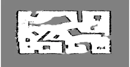
In this section, experiments are performed to evaluate the effectiveness of proposed map merging methodology. In order to perform map fusion task for two robots, partial occupancy grid maps are generated by each robots using particle filter based simultaneously localization and mapping algorithm. Occupancy grid mapping method is used to construct the model of the environment as seen in Fig. 1. [13]. It decomposes the high dimensional continuum mapping problem into a one dimensional mapping problem. The occupancy of each grid cell is estimated independently. Occupancy of a grid is a numerical value representing the posterior probability of a grid cell being occupied. Every grid has three states: occupied, free and unknown. This provides a simple spatial representation of the environment. Different cell states are represented by different colors. Black cells are related with obstacles which cannot be visited by the robots, gray ones show the unknown part of the environment and free space, where robots can navigate safely, represented with white color.
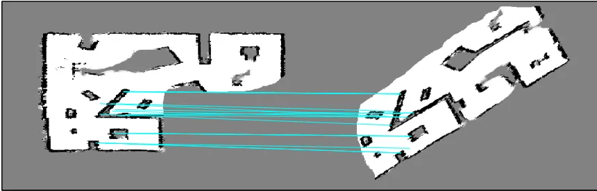
Imagine a search and rescue scenario in a complex and unknown disaster environment like semi-collapsed wide building occurred after an earthquake. Two robots, equipped with mapping and autonomous navigation capability, enter the unknown mission environment from different parts. They start to explore the environment independently from different part of the work area and extract partial local maps about traversed regions as seen in Fig.1.a for robot one and Fig.1.b for second robot. They construct the map of the work area with respect to their own reference frames which are different for each robot, so rotational, translational and scaling difference occur between the map of robot team members as seen in Fig.1.a and Fig.1.b. Second map has to be rotated, translated and scaled until similar regions between maps are overlapped. In a specific time, robots notice each other via communication ability and they exchange their local map to obtain global map to increase the efficiency of the overall system in the sense of time and energy. In order to calculate rigid transformation between partial occupancy grid maps, correspondence points between each robot partial maps are selected using our proposed methodology described in Section III.A and III.B. It can be easily observed that correspondence points are located in the overlapped region between partial maps as seen in Fig. 3. By using these matched key-points, rotation, translation and
[image:4.595.323.542.182.297.2]scaling are estimated (see Table I). The estimation error is smaller than one pixel and so we can say that obtained map is accurate, because robot maps are composed of 2500 pixels. Fig. 2 shows the resultant environment map after merging process using our proposed scale invariant feature transform based methodology. Merging operation took approximately 0.220 second which is a fast solution with respect to [5]. The simulations were performed on a Pentium Core 2 at 2.67 GHz with 2GB of memory computer.
[image:4.595.328.540.336.452.2]Fig. 1.a Partial Environment map of robot one
Fig. 1.b Partial Environment map of robot two
Fig. 2 Merged global mission environment map
TABLE I
CALCULATED TRANSFORMATION PARAMETERS
Rotation X Translation Y Translation Scale
Exact 30 -86 -36 0.95
Estimated 29,91 -85,79 -36,11 0.9503
V. CONCLUSION
[image:4.595.323.542.490.603.2]Fig. 3 Key points matching between two robot maps
used not only for mapping in structured environments, but also used in unstructured and complex environment which is an important issue for search and rescue operations. The main contribution of this work was threefold. First, proposed algorithm is capable of merging partial robot maps which have limited degree of overlapping regions. Second one is about the size of merged maps; local maps can be different size which is a very crucial property for heterogeneous multi-robot systems. Finally, our proposed map merging method works well and fast also in unstructured and complex environments.
REFERENCES
[1] G W. Burgard, M. Moors, C.Stachniss, “Coordinated multi-robot exploration”, IEEE Transactions on robotics, Vol. 21, 2005, pp. 376-386.
[2] D.Fox, J. Ko, K. Konolige, B. Limketkai, D.Schulz, B. Stewart, “Distributed multi-robot exploration and mapping”, In the Proceeding
of the IEEE, 2006, pp. 1325-1339.
[3] C.Stachniss, “Exploration and Mapping with Mobile Robots”, Ph. D. thesis University at Freiburg University, Computer Engineering Department, 2006.
[4] R. Zlot, A. Stentz, M. Dias, S. Thayer, “Multi-robot exploration controlled by a market economy”, In Proc. of ICRA, Washington DC, 2002, vol. 3, pp. 3016-3023.
[5] S. Carpin, A. Birk, V. Jucikas, “On map merging”, Robotics and
Autonomous Systems, 53 (1), 2005, pp. 1-14.
[6] S. Carpin, “Fast and accurate map merging for multi-robot systems”,
Autonomous Robots, 25 (3), 2008, pp. 305-316.
[7] K. Konolige, D. Fox, B. Limketkai, J. Ko, B. Stewart, “Map Merging for Distributed Robot Navigation”, In Proc. Of IEEE International
Conference on Intelligent Robots and Systems, 2003, pp. 212-217.
[8] N. Adluru, L. J. Latecki, M. Sobel, R. Lakaemper, “Merging maps of multiple robots”, In Proc. of 19th International Conference on
Pattern Recognition, 2008.
[9] X. Ma, R. Guo, Y. Li, W. Chen, “Adaptive genetic algorithm for occupancy grid maps merging”, In Proc. of the World Congress on
Intelligent Control and Automation , 2008, pp. 5704-5709.
[10] D. G.Lowe, “Distinctive image features from scale-invariant key points”, International Journal of Computer Vision, 60 (2), 2004, pp. 91-110.
[11] C. Belcher, Y. Du, “Region-based SIFT approach to iris recognition”,
Optics and Lasers in Engineering, 47 (1), 2009, pp. 139-147.
[12] D. Dueck, B. J. Frey, “Non-metric affinity propagation for unsupervised image categorization”, In Proc. of the IEEE
International Conference on Computer Vision, 2007.