International Journal of Innovative Research in Science, Engineering and Technology
An ISO 3297: 2007 Certified Organization Volume 5, Special Issue 11, May 2016
International Conference on Innovations in Engineering and Technology (ICIET'16)
6th & 7th April 2016
Organized by
K.L.N. College of Engineering and Technology, Madurai, Tamil Nadu, India
Localization based User Tracking Using RSSI
Fingerprint
R.Anandha Murugan, M.G. Roshini, P.S.P. Rubhini
Dept. of Computer Science Engineering, K.L.N. College of Engineering, Madurai, Tamil Nadu, India
ABSTRACT: To provide an accurate location many location systems with different technologies such as Wi-Fi, Beacon, GPS, etc,. can be used for indoor localization. One of the Biggest Challenges in indoor localization system is to determine the actual indoor position of the user using smart device (Mobile Phone). To design and implement an indoor localization system based on Received Signal Strength Indicator (RSSI) using Wireless Localization. For creating Geofence admin gives inputs latitude, longitude and radius from Global Positioning System (GPS). When user enters into certain GPS range, geofence will be triggered and entry, exit message is send to admin then store into database. Entire location has been divided and it is separated as segments for each segment user can get user location by fingerprinting Wi-Fi status. User can get RSSI (Received Signal Strength Indicator) from nearest Access points (Wi-Fi) then match with RSS Fingerprint database and track user location using Localization algorithm. Distance can be calculated by using access point of user location.
I. INTRODUCTION
Mobile phones, tablets, and ultra-portable laptops are no longer viewed as the wimpy siblings of the personal computer, for many users they have become the dominant computing device for a wide variety of applications.Many solutions are introduced to provide room-level location-based services, for example, locating a person or a printer in an office building. The majority of previous localization approaches utilize Received Signal Strength (RSS) as a metric for location determinations. RSS fingerprints can be easily obtained from most off-the-shelf wireless network equipment’s, such as Wi-Fi- or ZigBee-compatible devices.
In these methods, localization is divided into two phases: training and operating. In the first stage, traditional methods involve a site survey process (a.k.a. calibration), in which engineers record the RSS fingerprints (e.g., Wi-Fi signal strengths from multiple Access Points, APs) at every location of an interested area and accordingly build a fingerprint database (a.k.a. radio map) in which fingerprints are related with the locations where they are recorded. Next in the operating stage, when a user sends a location query with his current RSS fingerprint, localization algorithm retrieve the
fingerprint-according to a recent gartner report, within the next three years, mobile devices will surpass the PC as the
most common web access device worldwide.
II. LITERATURE SURVEY
is automated and no on-site survey or initial training is required to bootstrap the system. It is also quite responsive to environmental dynamics, as the impacts of physical characteristics changes have been explicitly figured in the mapping between the RSS measures and the actual geographical distances. We have implemented the proposed system with inexpensive off-the-shelf Wi-Fi hardware and sensory functions of IEEE 802.11, and carried out a detailed empirical study incur division building. The empirical results show the proposed system is quite robust and gives accurate localization results (i.e. with the localization error within 3 meters).We have witnessed swift advances in wireless communications and networking over the last decade. Such advances have made it possible to realize the notion of ubiquitous computing and communications. As a result, the capability for capturing contexts and figuring them into the computing/communication process has become an immediate need. As the physical location is one of the most important context parameters, its availability, as concluded independently in several market. It is also quite responsive to environmental dynamics.
[2] Yajuan Zhanga, Zili Zhanga, Daijun Weia, Yong Deng(2012)Many emerging location-aware applications require position information. However, these applications rarely use cell tower-based localization because of its inaccuracy, preferring instead to use the more energy-hungry GPS. In this paper, we present CAPS, a Cell-ID Aided Positioning System. CAPS leverages near-continuous mobility and the position history of a user to achieve significantly better accuracy than the cell tower-based approach, while keeping energy overhead low. CAPS is designed based on the insight that users exhibit consistency in routes traveled, and that cell-ID transition points that the user experiences can, on a frequently traveled route, uniquely identify position. To this end, CAPS uses a cell-ID sequence matching technique to estimate current position based on the history of cell ID and GPS position sequences that match the current cell ID sequence. We have implemented CAPS on Android-based smart-phones and have extensively evaluated it at different locations, and for different platforms and carriers. Our evaluation results show that CAPS can save more than 90% of the energy spent by the positioning system compared to the case where GPS is always used, while providing reasonably accurate position information with errors less than 20% of the cell tower-based scheme. The system develops a novel performance evaluation framework that is a hybrid between trace-driven simulation and real implementation.
[3] Solomon Chan, Gunho Sohn (2012)The past few years have seen wide spread adoption of outdoor positioning services, mainly GPS, being incorporated into everyday devices such as smartphones and tablets. While outdoor positioning has been well received by the public, its indoor counterpart has been mostly limited to private use due to its higher costs and complexity for setting up the proper environment. The objective of this research is to provide an affordable mean for indoor localization using wireless local area network (WLAN) Wi-Fi technology. We combined two different Wi-Fi approaches to locate a user. The first method involves the use of matching the pre-recorded received signal strength (RSS) from nearby access points (AP), to the data transmitted from the user on the fly. This is commonly known as “fingerprint matching”. The second approach is a distance-based trilateration approach using three known AP coordinates detected on the user’s device to derive the position. The combination of the two steps enhances the accuracy of the user position in an indoor environment allowing location-based services (LBS) such as mobile augmented reality (MAR) to be deployed more effectively in the indoor environment. The mapping of the RSS map can also prove useful to IT planning personnel for covering locations with no Wi-Fi coverage (ie, dead spots). The experiments presented in this research helps provide a foundation for the integration of indoor with outdoor positioning to create a seamless transition experience for users.
Trilateration method uses distance from nearby AP with known Media Access Control (MAC) addresses, calculated from signal strength values, to approximate the distance to the user. It is important to note that different networks of AP, particular ones with different hardware configurations, may vary in calculating the distance. Unlike fingerprinting, this method does not require priori data collection.
Wi-Fi fingerprinting requires a robust RSS database which will be used for generating signal strength maps as well as used for matching. Each reference point includes signal strength measured from all accessible AP. Live RSS data can then be compared to the find the closest match from the database which stores the location of each reference point. Fingerprint matching algorithm generally consists of two components: the radio map and the estimation method. The radio map must be established as part of the training phase to building up the database. The most commonly used estimation method, and also used in this experiment, is the Nearest Neighbourmethod. Other methods include the Support Vector Machine, as well as Hidden Markov Model.
localization algorithm. The paper proposes an improved RSSI-based algorithm, the experimental results show that compared with original RSSI-based localization algorithms the algorithm improves the localization accuracy and reduces the deviation.
Wireless localization algorithms can be roughly divided into two categories, Range-based and Range-free localization algorithms. Range-based localization algorithms mainly include RSSI-based trilateral localization algorithm, arrival angle algorithm (AOA), arrival time algorithm (TOA) and time difference of arrival (TDOA) algorithm. TOA requires precise clock synchronization, TDOA node is equipped with ultrasonic transmitters and receivers; AOA needs antenna array or microphone arrays. These three algorithms localization accuracy is high, however with high hardware requirements.
Range-free localization algorithm mainly includes centroid algorithm, DV-hop algorithm, MDS-MAP algorithm and convex programming. Range-free algorithms mainly use the geometric relationship between neighboring nodes to estimate localization. They have low hard-ware requirements, but the localization accuracy is too low for indoor environment. Because of its simple, easy-understanding and low cost, RSSI-based trilateral localization algorithm has a wide range of applications.
III. PROPOSED WORKS
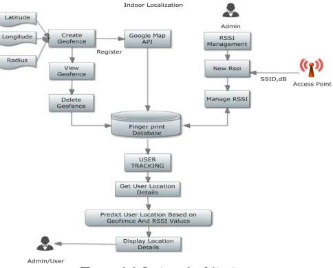
To predict the user in the indoor localization by using geofence creation and wireless indoor localization Using Google maps API admin have create the geofence for create the particular user location .The Geofence was triggered when user entry and exit status for the particular location. Then entire location has been divided and it is separated as segments for each segments user can get the user location by finger printing Wi-Fi status.
Figure 1.1 System Architecture
.In traditional approaches, fingerprints are geographically unrelated, losing the possibility of building fingerprint space. In fingerprint database, fingerprints are associated with their collecting locations (i.e., fingerprints are labeled with locations). Such associations are achieved by mapping fingerprint space (fingerprints) to stress-free floor plan (locations). In LiFS, the fingerprint database is updated continuously according to newly collected data, such that the database reflects the up-to-date radio signal distribution. As shown in fingerprint database, as the core component connects training and operating phase. In Operating phase, when a location query comes, usually an RSS fingerprint sent by a user, LiFS takes it as a keyword and searches the fingerprint database. The best matched item is viewed as the location estimation and sent back to users. To find the best matches, many searching algorithms can be used.
IV. MODULES
A. GEOFENCING
Geofencing software tools or applications that utilize global positioning systems (GPS) or radio frequency identification (RFID) to establish a virtual perimeter or barrier around a physical geographical area.
The Admin will activate the geofence for the all users then it will activate on each users. If user will be enter or exit to the particular location then it will be fetched through that particular user.
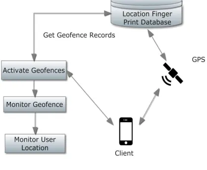
Figure 1.2 Geofencing
B. RSSI(Received Signal Strength Indicator)
RSSI is a Radio-Frequency (RF) term and stands for Received Signal Strength Indicator. It is a measure of the power level that a RF device, such as Wi-Fi or 3G client, is receiving from the radio infrastructure at a given location and time. For instance, the power level a laptop is detecting from a nearby AP. Signal Transmitter has transmit signals in certain decibels(dB) the receivers gain range has varied from depending upon the location .By using signal measurement of received signal strength indication we can measure distance from the transmitter and receiver.
Here we use the RSSI methodology for location estimation for android indoor location. The Location Fingerprints are stored in the particular Locations only. These phase is consist of two phases testing phase and evaluation phase. In the testing phase user has import the location fingerprints into the location finger print database after that of location finger printing use.
C. WIRELESS LOCALIZATION
The location estimation methods can be classified into target/source localization and node self-localization. Due to the availability of such low energy cost sensors, microprocessor, and radio frequency circuitry for information transmission, there is a wide and rapid diffusion of wireless sensor network (WSN).
The Indoor localization has retrieves the user location measurement by using wireless network devices. The Outdoor localization can be done with geofencing. But predicting user location information has to be only done with the wireless localization method.
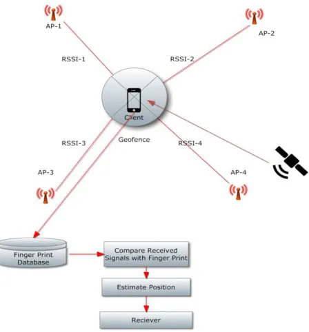
Figure 1.3 Wireless Localization
D INDOOR LOCALIZATION
An Indoor Localization is a system to locate objects or people inside a building using radio waves, magnetic fields, acoustic signals, or other sensory information collected by mobile devices. There are several commercial systems on the market, but there is no standard for an Indoor Localizationsystem. Systems use different technologies, including distance measurement to nearby anchor node.
They either actively locate mobile devices and tags or provide ambient location or environmental context for devices to get sensed. Here we used the wireless localization and RSSI finger print methodology to identifying the user corresponding location. The location finger print methodology was find out the indoor measurement Indoor localization has been adopted with that particular respective.
Figure 1.4 Indoor Localization EUSER TRACKING
User has been login into that particular location the user location monitoring will be increased through that particular location also user has been the user will be handling that particular location.
By using user location information’s are fetched out from the user location finger print database that will be fetched out from the user location.
Only the user information are fetched through that entire application also every user from their entire applications can leverage fetched out from user location. The user tracking can be done through that particular user information are fetched and matched with that location finger print database.
Figure 1.5 User Tracking
V. CONCLUSION
To predict user particular location in indoor localization using geofence creation and wireless indoor localization with Google Map API admin. User will register and login, it will show the user particular location. For creating geofence by GPS, latitude and longitude will be monitored and stored. The geofence are triggered when the user enter into created geofence. Admin can create, view and delete geofence. Admin will get RSSI fingerprint value from Wi-Fi access points and store in RSS fingerprint database. While tracking the user it will match current RSSI with stored database. Then admin will track the user location in created geofence.
REFERENCES
[1] Azizyan M, Constandache I, and Roy Choudhury(2009) ’Surroundsense: Mobile phone localization via ambience fingerprinting’ in Proc. ACM 15th Annu. Int. Conf. Mobile Comput.Netw., pp.261–272.
[2] Bahl P and Padmanabhan V.N. (2009) ‘RADAR: An in-building RFbased user location and tracking system’ in Proc. IEEE Conf. Comput. Commun., vol. 2, pp. 775–784.
[3]Chen Y, Lymberopoulos D, Liu J, and Priyantha B. (2012) ‘FM-basedindoor localization’ in Proc. ACM 10th Int. Conf. Mobile Syst.,Appl. Serv., pp. 169–182.
[4] Chintalapudi K, Iyer A.P., and Padmanabhan V.N. (2010) ‘Indoorlocalization without the pain’ in Proc. ACM 16th Annu. Int. Conf.MobileComput. Netw., pp. 173–184.
[5]Paek J, Kim K.H., Singh J.P., and Govindan R (2011) ’Energy-efficientpositioning for smartphones using cell-id sequence matching’ inProc. 9th Int. Conf. Mobile Syst., Appl., Serv., pp. 293–306.
[6] Park J, Charrow B, Curtis D, Battat J, Minkov E, Hicks J, Teller S,and Ledlie J (2010) ‘Growing an organic indoor location system’ in Proc.ACM 8th Int. Conf. Mobile Syst., Appl. Serv., pp. 271–284.
[7] Solomon Chan, Gunho Sohn (2012) ‘Indoor localization using Wi-Fi based fingerprint and Trilateration techniques for LBS application’ GeoICT Lab, Earth and Space Science and Engineering Department, York University, Toronto Canada.,