International Journal of Emerging Technology and Advanced Engineering
Website: www.ijetae.com (ISSN 2250-2459,ISO 9001:2008 Certified Journal, Volume 3, Issue 10, October 2013)
274
Land Use/Land Cover Analysis Through Remote Sensing and
GIS Techniques: A Case Study of Vizianagaram District,
Andhra Pradesh, India.
N. Appala Raju
1, K. Harikrishna
2, P. Suneetha
3, S. Sachi Devi
41,3,4Department of Geography, Andhra University, Visakhapatnam-530003 2
Department of Geo-Engineering, College of Engineering (A), Andhra University, Visakhapatnam-530003
Abstract--- The rapidly developing technology of Remote Sensing offers an efficient and timely approach for mapping the land resources. The land use/ land cover dynamics of the newly formed district Vizianagaram of Andhra Pradesh have been characterized and evaluated using Remote Sensing and Geographic Information System (GIS). The land use/land cover types as identified are agriculture land, built-up land, forest land, and wasteland and water bodies. About 68% of the total geographical area of the district is covered by agricultural land followed by forestland (15% of TGA) and wasteland (10% of TGA), while built up land covers only 1 percent of total geographical area.
Keywords-- Land use/Land cover, Geographic Information System (GIS), Remote Sensing, Agricultural land, Forest, Water bodies and Waste land.
I. INTRODUCTION
Land, the basic natural resource is important to every individual and every nation but its importance to those who depend on its direct use multiplies with increasing intensity of use. In the developing countries like India where agriculture is the main source of economy and livelihood for more than two thirds of the working population, utilization of land resource plays a vital role in shaping the fabric of life and economy of the country. In recent years the serious concern is the question of ecological management and optimum utilization of land resources for the benefit of mankind. The use of land resource is central to all discussions of land problems and policies.
In land use classification one can normally distinguish different land use types on the basis of general purpose. The major land use types can be classified further for understanding the geographical character of land resource potential at micro scale. In the study region the utilization pattern of major land use types is analyzed. The pattern of land use that exists in a region is the outcome of continuous interaction between the given physical elements and human factor characterized by prevalent socio-cultural and economic environments (Singh 2000).
The present study is an attempt to analyses the land use/ land cover categories of Vizianagaram district. Number of research papers were published relating to land use and land cover analysis. Alaguraja, P. and Durairaju, S., (2010) have analyzed Land use/ Land Cover categories i.e. crop land, dense forest, fallow land, barren rocky land, land with or without scrub, plantations and water bodies of Madurai district in Tamilanadu using satellite data. Chaurasia et al (1995) studied the agricultural land use change in Bathinda Dt., Punjab through Remote Sensing Techniques. Singh et al (2000) studied the agricultural land use of Alomara and Bageswar districts of Uttaranchal, by analyzing land use categories and also major food grain crops viz. wheat, barley, paddy and other crops. Minakshi. P.K, and Sharma Virat Devasar, (2004) have studied systematically Land use/Land cover categories i.e. built up land, agricultural land, forest, waste land, water bodies and mining and brick kilns of Fatehgarh Sahib District Punjab. Ravi Singh (2000) studied land use levels of agricultural development in Arunachal Pradesh. Shah G.L and Archana. K Roy, (2006) have analysed techniques of supervised classification in Land Cover/Land Use Mapping: A Case of Rishikesh, Uttarakhand. Land use/Land cover classes of Pilibhit District in Uttar Pradesh were studied by Nayak.S and Behera MD (2008). Veena U. Joshi and Vikas Nagare, (2010) has systematically analysed Land-Use/Land-Cover classes in Paravara River Basin. K.Harikrishna et. Al., (2011) has systematically analysed Land use/Land cover classes in Greater Visakha Municipal Corporation (GVMC), K.Harikrishna et. Al., (2013) studied systematically Land use/Land cover categories i.e. built up land, agricultural land, aquaculture, forest, waste land and water bodies around Kolleru Lake.
II. OBJECTIVES
International Journal of Emerging Technology and Advanced Engineering
Website: www.ijetae.com (ISSN 2250-2459,ISO 9001:2008 Certified Journal, Volume 3, Issue 10, October 2013)
275
III. DATA USED AND METHODOLOGYAnalysis was carried out by image processing of IRS- LISS III data of March 2009 using ERADAS imagine 9.1 software. The Survey of India topographical maps nos 65M/8, 65M/12, 65N/2, 65N/3, 65N/4, 65N/5, 65N/6, 65N/7, 65N/8, 65N/9, 65/N10, 65N/11, 65N/12, 65N/13, 65O/1, 65O/5 & 65O/9 were scanned, geo-referenced and all the maps were subset and mosaic using the ERDAS Imagine environment. After applying necessary enhancement techniques, digital data have been converted to vector formats for further GIS analysis. Based on the information obtained from the satellite imagery and corresponding ground truth verification in the field, various categories of the land use have been identified. The agricultural land, built up land, forest land, water bodies, mining/ industrial, wasteland and wet lands/inland naturals are the major land use/ land cover units identified and mapped in the study area (Fig.1, 2 & 3) and their statistical data is given in Table 1.
IV. STUDY AREA
Vizianagaram District covers geographical area of 6,539 Sq.kms (Fig.1) and lies between latitudes of 170 50’ to 19015’ N and longitudes of 83000’ to 83045’ of the E. The normal annual rainfall of the district 1131 mm. the district gets the benefit of both the South West and North East monsoons.
Agricultural Land
Agricultural land includes cultivated crop land in both Rabi as well as Kharif seasons and agricultural plantations. The total area under this category is 4,423.6 Sq.Kms, which comes out to be 68 percent of the total geographical area of the district. The area under transport net work, canal and drainage net work is also included, as this could not be mapped separately due to scale limitations.
The plantations such as Mango, Cashew nut and Eucalyptus are also present in the study area which are scattered in patches.
Forest Land
The total area occupied by the forests is 972.82 Sq.km and accounts for 14.87 percent of the total geographical area of the district. There are some reserved forests in the district. The forest area is much less than the required area of 33.3 percent under forest plantations for ecological balance as per the National Forest Policy. The forests include mainly deciduous types which occupy 10% of the total forests and remaining 4% includes other categories of forests.
Waste Land
Waste land category includes mainly dense scrub land covered an area 451.69 Sq.Kms while at few places, patches of open scrub land prevail in the north eastern part of the district. The Gullied or Ravenous land covered an area of 42.96 Sq.km. Total barren rocky or stony wasteland spreads over an area of 36.14 Sq.km. The total wasteland in the district covered 632.8 Sq.km, of area and represents 9.67 percent of the total area of the district.
Built Up Land
International Journal of Emerging Technology and Advanced Engineering
Website: www.ijetae.com (ISSN 2250-2459,ISO 9001:2008 Certified Journal, Volume 3, Issue 10, October 2013)
276
International Journal of Emerging Technology and Advanced Engineering
Website: www.ijetae.com (ISSN 2250-2459,ISO 9001:2008 Certified Journal, Volume 3, Issue 10, October 2013)
277
International Journal of Emerging Technology and Advanced Engineering
Website: www.ijetae.com (ISSN 2250-2459,ISO 9001:2008 Certified Journal, Volume 3, Issue 10, October 2013)
278
International Journal of Emerging Technology and Advanced Engineering
Website: www.ijetae.com (ISSN 2250-2459,ISO 9001:2008 Certified Journal, Volume 3, Issue 10, October 2013)
279
Table.1
Land Use/ Land Cover Statistics
Land Use/ Land Cover category Area
S.No Level I Level II Area in Sq.kms % of the total geo. area
1 Agricultural Land
Crop land 3944.2 60.3
Plantation 479.4 7.7
Sub total 4423.6 68.0
2 Built up Land Urban 20.69 0.3
Rural 71.89 1.0
Sub total 92.58 1.3
3 Forest
Forest-deciduous dry/moist/thorn/dense
710.36 10.8
Forest deciduous - open 178.40 2.7
Forest- Plantation 5.61 0.08
Forest- Scrub Forest 78.45 1.1
Sub total 972.82 14.87
4 Waste Land
Barren Rocks/stony waste 36.14 0.5
Gullied/Ravenous land 42.96 0.6 Sandy area –coastal 1.86 0.02 Scrub land -dense scrub 451.69 6.9 Scrub land -open scrub 100.18 1.5
Sub total 632.8 9.67
5 Water bodies
Canal/drain 2.09 0.03
Reservoir/tanks-dry 175.76 2.68 Reservoir/tanks-dry Kharif
extent
94.10 1.43
Reservoir/tanks-dry Rabi extent 39.76 0.60 Reservoir/tanks-dry zaid extent 16.04 0.2 Reservoir/tanks-Perennial 5.25 0.08
River/stream-dry 40.82 0.6
River/stream- Perennial 31.52 0.48
Sub total 405.34 6.1
6 Other Mining/industrial 11.14 0.1
Wet lands- inlands 0.67 0.01
Sub total 11.81 0.11
Water Bodies
Tanks are the main water resources in the district. The area occupied by these tanks comes out to be 405 sq.km, which is 6.1 percent of the total geographical area.
International Journal of Emerging Technology and Advanced Engineering
Website: www.ijetae.com (ISSN 2250-2459,ISO 9001:2008 Certified Journal, Volume 3, Issue 10, October 2013)
280
OthersThe mining/industrial area covered 11.14 sq.km of land which includes Bauxite and manganese deposits while wet lands/ inland natural occupy 0.67 sq.km of land. The total area covered in this category is 11.81 sq.km.
V. STATUS OF LAND USE/LAND COVER OF VIZIANAGARAM DISTRICT COMPARISON TO ANDHRA
PRADESH STATE
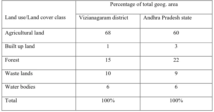
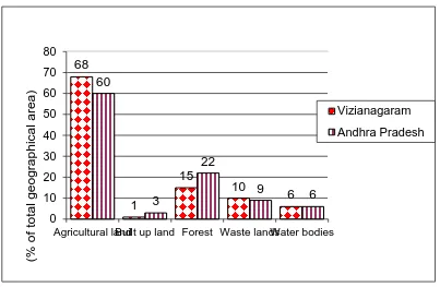
The present status of land use in the district Vizianagaram as shown in Table.2 shows that the major area of the district is under agricultural land (68%) which is considerably high in comparison to state i.e. 60% (Fig.4&Table.2).
This area is intensively cultivated and irrigated. The waste lands lying as barren at present can also be brought under cultivation after proper reclamation. The waste land cover 10 percent of the total Geographical area (TGA) is slightly greater than the state average (9%).
[image:7.612.119.493.339.535.2]The area under forest cover is 15% of total geographical area, and is less than the recommended norms of the National forest policy and less than state average figure of 22%. The waste land area is identified as 10% in the district and it is being converted into the agricultural land. The built up land cover is 1 percent total geographical area which is less than state average (3%). The area under water bodies is 6% to total geographical area, which is equal to state average.
Table 2
Status of Land use/land covers of district Vizianagaram district in comparison to Andhra Pradesh state
Land use/Land cover class
Percentage of total geog. area
Vizianagaram district Andhra Pradesh state
Agricultural land 68 60
Built up land 1 3
Forest 15 22
Waste lands 10 9
Water bodies 6 6
International Journal of Emerging Technology and Advanced Engineering
Website: www.ijetae.com (ISSN 2250-2459,ISO 9001:2008 Certified Journal, Volume 3, Issue 10, October 2013)
[image:8.612.100.503.134.397.2]281
Fig. 4: Land utilization statistics
VI. CONCLUSIONS
The present study has demonstrated the potential of remote sensing technology for mapping the land use/land cover status of an area. This basic study shows how to classify land use and land cover from satellite imagery. The land use and land cover map clearly shows that area of crop land is higher than others. Forest land extends over 972 sq km area and it occupies second place in this district, waste land spreads over 632 sq km and water bodies occupied 405 sq km, and other land use categories have occupied lower than 11 sq.km of area. The results show that Vizianagaram district has average agricultural potential and the area under waste land is also in higher percentage.
REFERENCES
[1 ] Alaguraja, P. and Durairaju, S., (2010): “Land use Land Cover Mapping - Madurai District, Tamilnadu, India Using Remote Sensing and GIS Techniques” International Journal of Civil and Structural Engineering, Vol.1, No. 1, Pp.91-100.
[2 ] Chaurasia, R. Loshali, D.C. Dhaliwal S.S and Sharma P.K (1995): “Assessing the change in Agricultural land in Bathinda Dt., Punjab through Remote Sensing Techniques” National Geographical Journal of India, Vol. 41(1), Pp. 39-44.
[3 ] K.Harikrishna, N.Appala Raju, V.Venkateswara Rao, G.Jaisankar, E.Amminedu. (2011). Land Use and Land Cover Mapping Analysis through Remote Sensing and GIS Techniques – A case study of GVMC”. Journal of Applied Hydrology (JAH), XXIV – No.1&2, Jan. & Apr. 2011, PP. 1-8.
[4 ] K.Harikrishna, N.Appala Raju, V.Venkateswara Rao, G.Jaisankar and E.Amminedu, (2013). Land Use/Land Cover patterns in and around Kolleru Lake, Andhra Pradesh, India using Remote Sensing and GIS techniques”. International Journal of Remote sensing and Geoscience, Volume 2, Issue 2, pp. 1-7.
[5 ] Madhuri .S and Ramanaiah.Y.V, (2007) “Land use intensification and Diversification for sustainable agriculture – A case study of Rayalaseema region, Andhra Pradesh, India” Indian Journal of Regional Science, Vol. XXXIX, No.1, Pp. 134-139.
[6 ] Minakshi. P.K, Sharma Virat Devasar, (2004): “Land Use/Land Cover of Fatehgarh Sahib District Punjab” National Geographical Journal of India, Vol. 50, No. (3-4), Pp. 79-86.
[7 ] Nayak.S and Behera MD. (2008): “Land Use/Land Cover Classification and mapping of Pilibhit District, Uttar Pradesh, India” The Indian Geographical Journal, Vol.83, No.1, Pp.15-24.
[8 ] Ravi Singh, (2000): “Land use and Levels(s) of Agricultural development in Arunachal Pradesh” National Geographical Journal of India, Vol.46 (1-4), Pp. 69-80.
[9 ] Shah G.L and Archana. K Roy, (2006) “Techniques of supervised classification in Land Cover/Land Use Mapping: A Case of Rishikesh, Uttarakhand” National Geographical Journal of India, Vol. 52, Pp. 163-170.
[10 ]The chief planning officer, (2007-2008): Vizianagaram District Handbooks of statistics.
[11 ]Veena U. Joshi and Vikas Nagare, (2010): “Temporal Changes in the Land-Use/Land-Cover for the last one Decade along the Paravara River Basin” Journal of the Institute of Indian Geographers, Vol.32, No.2, Pp.183-192.
68
1
15
10
6
60
3
22
9
6
0
10
20
30
40
50
60
70
80
Agricultural landBuilt up land Forest Waste landsWater bodies