ISSN(Online): 2320-9801
ISSN (Print): 2320-9798
I
nternational
J
ournal of
I
nnovative
R
esearch in
C
omputer
and
C
ommunication
E
ngineering
(An ISO 3297: 2007 Certified Organization)
Vol. 4, Issue 8, August 2016
Predicting Bus Arrival Time using GPS on
Android Phone Based Application
Amruta Zagade, Vaishnavi Langhe, Trupti Gawari, Prof. Milind Hegade
Dept. of Computer Engg, BSIOTR, Savitribai Phule Pune University, Pune, India
ABSTRACT: In order to facilitate the introduction of transit and arrival time prediction in smaller transit agencies,we investigate an automatic,smartphone-based system which wecall Easy Tracker,a transit agency must obtain smartphones, install an app, and place a phone in each transit vehicle. Our goal is to require no other input. This level of automation is possible through a set of algorithms that use GPS traces collected from instrumented transit vehicles to determine routes served, locate stops, and infer schedules. The primary information to most city transport travelers is bus arrival time. It often discourages the passengers for excessively waiting long time at bus stops and makes them reluctant to take the public transport, buses. To enable the passenger to track the vehicle or bus an electronic device is installed in a vehicle is known as Vehicle tracking System. This paper proposes a bus arrival time prediction using GPS and GSM technology. It would also work as antitheft system and cheapest source of vehicle tracking. It is an embedded system using GPS (Global Positioning System), GSM (Global System for Mobile Communication) and Microcontroller for tracking the bus. The real time co-ordinates obtained from the GPS will continuously monitor a moving vehicle and report the status of the vehicle on request to passengers. The GPS/GSM unit is mounted on the bus sends the data to the central monitoring system microcontroller using the GSM module and displays bus location name on the LCD. The position i.e Latitude and Longitude of a vehicle from remote place is sent by the GSM module to the Server and then the server calculates the arrival time of the bus and sends to the requested user through GSM module.
KEYWORDS: GPS, kalman filter Bus Tracking, Bus arrival time and Android phones.
I. INTRODUCTION
The transportation system serves as the heart in the economic and social development of the country. Due to the fast rate of population in India there is a rapid increase in vehicle which results in a burden on metropolitan traffic management. As the public transport has become an important part of the urban transportation advance in easily available technology can be implemented which not only help the person who commutes between a suburb and city to get the travelling information and also help a person in command to track down there fleet with the final real time location [1].In many parts of the world, public transport especially the bus transport has been well developed. In order to reduce the fuel consumption, private car usage and alleviate traffic congestion we can use the bus transport services. The passengers want to know the accurate arrival time of the bus, when travelling with the buses. The passengers become anxious while extremely waiting for a long time at the bus stop and make them hesitant to take buses. Many travelers are usually late to office and most of the students are delayed to the class as they decide to wait for the bus instead of taking an alternate transportation.
The passengers can make an exact decision of whether or not to wait at a bus stop if they had an easy approach to see which bus is near to their location and an accurate time it would take to reach the bus stop. A design of an embedded system which is used for tracking and positioning of any vehicle by using Global Positioning System (GPS) and Global system for mobile communication (GSM) is proposed in this paper. A combination of computer hardware and software, and perhaps additional mechanical part designed to perform a specific function is known as an Embedded System. An embedded system is software driven, real-time control system, microcontroller-based, reliable, human or network interactive, autonomous, operating on diverse physical variables and in diverse environments and sold into a competitive and cost conscious market.
In this paper, our goal is to reduce the cost and complexity of offering these services by creating Easy Tracker, an automatic system for transit tracking, mapping, and arrival time prediction.
ISSN(Online): 2320-9801
ISSN (Print): 2320-9798
I
nternational
J
ournal of
I
nnovative
R
esearch in
C
omputer
and
C
ommunication
E
ngineering
(An ISO 3297: 2007 Certified Organization)
Vol. 4, Issue 8, August 2016
system directly to the rider. This paper presents an algorithm developed in an APTS project whose primary objective was twofold: 1) development of real-time departure information displays for transit vehicles and 2) use of such displays to provide riders waiting at transit centers with useful information. This paper discusses the development of an algorithm to accurately predict arrival times of vehicles given both real-time data on a vehicles position and information about its path.
II. EXISTING SYSTEM
The bus companies usually provide free bus timetables on the web. Such bus timetables, however, only provide very limited information (e.g., operating hours, time intervals, etc.), which are typically not timely updated according to instant traffic conditions. Although many commercial bus information providers offer the real time bus arrival information, the service usually comes with substantial cost. With a fleet of thousands of buses, the installment of in- vehicle GPS systems incurs tens of millions of dollars. The network infrastructure to deliver the transit service raises the deployment cost even higher, which would eventually translate to increased expenditure of passengers. Participatory Sensing, user activity recognition and Urban Sensing provides a rich contextual information for applications of mobile such as location based services and social networking. Mobile devices consumes huge amount of energy by continuously capturing this contextual information. A new design framework for an Energy Efficient Mobile Sensing System (EEMSS) is proposed in this paper.
III.PROPOSED SYSTEMARCHITEECTUREANDOVERVIEW
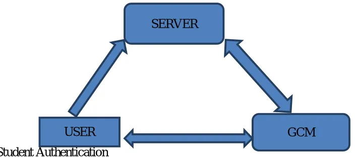
This system consists of four main components
1. Smartphone - installed in each bus or vehicle, which functions as a tracking device or an automatic vehicle location system.
Student Authentication
Reply
Fig 1.System Design Overview
IV.MODULES
1. Module on server side:
USER
SERVER
ISSN(Online): 2320-9801
ISSN (Print): 2320-9798
I
nternational
J
ournal of
I
nnovative
R
esearch in
C
omputer
and
C
ommunication
E
ngineering
(An ISO 3297: 2007 Certified Organization)
Vol. 4, Issue 8, August 2016
2. MODULE INSIDE THE BUS:
In inside bus module, GPS devices has installed in bus that device have minimum 12v battery backup. GPS device continuousally collect the information and that information sent to server.
3. MODULE FOR USERS (ANDROID):
In user side module, each client have android application through that application client can send request to server for getting information about bus location and arrival time of bus where the user waiting at our bus stop.
4. MODULE FOR RESTRICTED AREA ALARM
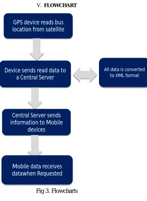
In User side Module,each client have android applicationthrough that client can get a alarm when he reaches near to its stop or a Particular restricted area. Following figure.2 showing the system Arcitecture
Bus GPS
Device
Central Server
Central Server
Data Converted
to XML file by
Central Server
DATARequest
XML File
1
3
4
ISSN(Online): 2320-9801
ISSN (Print): 2320-9798
I
nternational
J
ournal of
I
nnovative
R
esearch in
C
omputer
and
C
ommunication
E
ngineering
(An ISO 3297: 2007 Certified Organization)
Vol. 4, Issue 8, August 2016
V. FLOWCHART
Fig 3. Flowcharts
VI.CONCLUSION
We present a GPS based bus arrival time prediction system. Primarily relying on inexpensive and
widely available cellular signals, the proposed system provides cost-efficient solutions to the
problem. .This paper proposes the bus tracking and prediction of the bus arrival time with a
proposed system in it. This system is turn on and uses i.e. works anywhere on earth and does not
require a laboratory or artificial environment. Having a GPS is truly an advantage you can
determine your location, whether you are travelling to locally or in a foreign land and if you think
you are lost, you can use your GPS devices receiver to know your exact location
REFERENCES
GPS device reads bus
location from satellite
Device sends read data to
a Central Server
Central Server sends
information to Mobile
devices
Mobile data receives
datawhen Requested
ISSN(Online): 2320-9801
ISSN (Print): 2320-9798
I
nternational
J
ournal of
I
nnovative
R
esearch in
C
omputer
and
C
ommunication
E
ngineering
(An ISO 3297: 2007 Certified Organization)
Vol. 4, Issue 8, August 2016
3) Ramjattan, A.N. and P.A. Cross. “A Kalman Filter Model for An Integrated Land Vehicle Navigation System”.Journal of Navigation, Vol.
48, No. 2, May 1995, pp. 293-302.
4) Anderson, B.D.O. and J.B. Moore.”Optimal Filtering.” Prentice-Hall, Inc., Englewood Cliffs, NJ, 1979.
5) Sudhakar K N1, Rashmi K ,”Predicting the Bus Arrival Time Using GPS and GSM Technology “,IJSR, 2013.
6) TransitGenie Chicago. http://www.transitgenie.com.
7) James Biagioni ,Tomas Gerlich, and Timothy Merrifield “EasyTracker: Automatic Transit Tracking, Mapping, and Arrival Time Prediction
Using Smartphones”.
8) A. Thiagarajan, J. Biagioni, T. Gerlich, and J. Eriksson. Cooperative transit tracking using gps-enabled smartphones. In SenSys, pages 85–98.
ACM, 2010.