Procedia Environmental Sciences 24 ( 2015 ) 222 – 227
1878-0296 © 2015 The Authors. Published by Elsevier B.V. This is an open access article under the CC BY-NC-ND license (http://creativecommons.org/licenses/by-nc-nd/4.0/).
Selection and peer-review under responsibility of the LISAT-FSEM Symposium Committee
doi: 10.1016/j.proenv.2015.03.029
ScienceDirect
The 1st International Symposium on LAPAN-IPB Satellite for Food Security and Environmental
Monitoring
Object-based image analysis for coral reef benthic habitat mapping
with several classification algorithms
Nurhalis Wahidin
a,b,*, Vincentius P. Siregar
c, Bisman Nababan
c, Indra Jaya
c, Sam
Wouthuyzen
daMarine Technology Graduate Program, Faculty of Fisheries and Marine Sciences, Bogor Agricultural University, Bogor, Indonesia bFaculty of Fisherie and Marine Science, Khiarun University, Ternate, Indonesia
cDepartment of Marine Science and Technology, Bogor Agricultural University, Bogor, Indonesia dOceanographic Research Center, Indonesian Institute of Science, Jakarta, Indonesia
Abstract
Object-based classification technique (OBIA) in Landsat image analysis is assumed to be able to increase classification accuracy result compared with a pixel-based classification technique. Most of the previous research was conducted using conventional (pixel-based) classification technique such as maximum likelihood algorithm. The objective of this research was to determine accuracy values of coral reef habitat classification based on OBIA algorithms such as Support Vector Machine (SVM), Random Tree, Decision Tree (DT), Bayesian, and k-Nearest Neighbour (KNN). The Landsat 8 OLI satellite imagery acquired on 17 October 2013 on coral reef area in Morotai island, North Maluku Province, Indonesia was analysed in this study. Field data was obtained in October 2012 using transect photo technique. The field data was then classified employing OBIA classification within 7 (seven) classes i.e., sand-rubble, rubble, coral, sand, sand-algae, seagrass, and rubble-sand. Results showed that the highest values of overall accuracy and Kappa on coral reef habitat mapping was produced by SVM algorithm which reached 73% and 0.64 followed by RT, KNN, Bayesian, and DT algorithms of 68% and 0.59, 67% and 0.56, 66% and 0.53, and 56% and 0.46, respectively. Those results showed that the classification methods based OBIA approach within > 6 classes produced better accuracy than the pixel based classification technique.
© 2015 The Authors. Published by Elsevier B.V.
Selection and peer-review under responsibility of the LISAT-FSEM Symposium Committee
Keywords: Object-based classification; pixel-based classification;coral reef benthic habitat;overall accuracy; Kappa; Morotai island
* Corresponding author. Tel.: +62-811-1137-475. E-mail address: [email protected]
© 2015 The Authors. Published by Elsevier B.V This is an open access article under the CC BY-NC-ND license (http://creativecommons.org/licenses/by-nc-nd/4.0/).
1. Introduction
Spatial information about composition, condition, and dynamics of coral reef is very important for understanding and managing a coral reef ecosystem. A coral reef mapping activity in remote sensing using aerial photo and satellite sensor has been widely used and very efficient in term of cost compared to a field observation. Coral reef that relatively grow and form on the shallow and clear water can be detected by optical (passive) satellite sensor and the data is mostly available.
Landsat TM and ETM+ is the most common satellite sensor used, but their abilities to differentiate between reef and its association are limited because of their capabilities in spatial and spectral resolutions. Pixel size of Landsat which is categorized in medium level (30 m) may contain several habitats in one pixel causing inaccurate (error) in a classification habitat. Narrow spectral reflectance differences among reef, seaweed, and algae produce difficult differentiation by tri-band Landsat sensor even though the sensor can penetrate water column up to about 30 meters deep [1, 2, 3]. In some previous studies of pixel-based benthic habitat mapping employing Maximum Likelihood (MLH) classification algorithm, the Landsat TM and ETM+ sensors were sufficient for mapping reef, sand, and seaweed, but cannot differentiate more than 6 classes of different habitats. Mumby et al. [4] stated that the accuracy of coral reef benthic habitat maps using Landsat image for small class number (4 classes) reached 73%, but only 52% and 37% for 8 and 13 classes, respectively. Other studies showed that the accuracy values for coral reef benthic habitat mapping using Landsat imageries with more than 6 classes of classification scheme on several different locations were about 53-56% [5]. Using higher resolution of IKONOS, Mumby et al. [6] reported that classification accuracy value of 60% was found when mapping marine environment with more than 6 classes. Most of the classification technique for mapping coral reef benthic habitat is based on pixel-based approach [7]. One of the alternative approaches is segmentation which involves pixel combination for identifying object to be classified. This technique is called an object-based classification technique. This technique is mostly applied for land area mapping with high accuracy value, e.g. Wang et al. [8] integrated object-based and pixel-based classifications for mapping mangrove using IKONOS images produced accuracy value of 91.4%. Coral reef mapping with object-based approach using Landsat ETM+ image on some levels of class number for coral reef benthic habitat showed that pixel-based classification technique with MLH algorithm reached 54.4% accuracy. On the other hand, object-based classification with hybrid algorithm was able to reach 62.8% accuracy at intermediate class (> 6 classes) [17]. The Landsat 8 OLI sensor which was launched on 11th of April 2013, equipped with 4 bands multispectral, and can penetrate water column, was expected to be an alternative tool for improving the accuracy of coral reef benthic habitat mapping with object-based classification technique. The objective of this study was to determine the ability of object-based classification technique for coral reef benthic habitat mapping using the Landsat 8 OLI image employing some hybrid classification algorithms at more than 6 number of classes.
2. Methodology
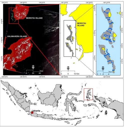
This research was conducted at shallow water ecosystem area in western part of Morotai Island, North Maluku Province. Geographically, the study site was located between 128°10'14.80"-128°14'26.76" east longitude and 1°59'28.66"-2°13'46.18" north latitude. The study region exhibited a barrier reef type extending from north to south along the island (Figure 1).
We used the Landsat-8 OLI (Operational Land Imager) satellite image path/row 109/059 acquired on 17 October 2013 covering some parts of Morotai Island and East Halmahera Regency of North Maluku Province. The data was downloaded from USGS Earth Resources Observation and Science data centre (http://glovis.usgs.gov/) of Level 1T. The data had been geometrically corrected (Terrain Corrected) and projected to UTM coordinate system in zone 52N-WGS84. Field data for shallow water benthic habitat data were collected in October 2012 using photo transect technique with 200 observation points.
Fig. 1. Research location and Landsat 8 image scene. Blue dots on the above right map indicated field observation points
Pre-processing image steps consisted of atmospheric correction, area cropping for further study analyses, land and water area masking, and water column correction. Atmospheric correction was performed using FLAASH on ENVI version 5.1 software to convert image digital values into surface reflectance values based on the calibration coefficient found in the Landsat metadata. Atmospheric correction was applied only to 7 bands multispectral Landsat-8 OLI (1, 2, 3, 4, 5, 6, 7) and not included in panchromatic (8), Cirrus (9), and TIRS (10, 11) bands. Image after atmospheric correction was cropped and masked using composition band of 1, 2, 3, 4, 5. Final step of image pre-processing was water column correction with the composition of visible band. This technique was suggested by Lyzenga [9] which wasconducted by extracting identified area from image on the same substrate (sand) within different depth, then the image was transformed into logarithm values for different bands and calculating regression values of band pairs was performed. Slope value of regression (ki/kj) was calculated based on the equation suggested by Green et al. [10]. Water column correction later produced 6 bands of depth invariant index (DII) with composition of DII_12, DII_13, DII_14, DII_23, DII_24 and DII_34 used as input variables in the OBIA classification process.
Class of coral reef benthic habitat was defined from field observation result using application of Coral Point Count with Excel extension (CPCE) [11]. Class division of classification scheme was determined based on similarity value of benthic component cover percentage using Bray-Curtis Similarity’s equation coefficient [12] with the dissimilarity value of 40% [13]. From 200 observation points, we divided into several benthic habitat classes and selected 100 points for classification accuracy assessment. From 200 observation points, we also categorized the benthic habitat into 10 substrate classes i.e., sand, reef fragment, rock, seaweed, dead reef with algae, other fauna, alga, sponge, gorgonian, and live coral.
Object-based classification was applied with multi-resolution segmentation algorithm based on the parameters of weight, color, texture, and shape to some scale levels of segmentation. Therefore, there was no requirement for standard parameter score in this object-based classification. The algorithm tested the classification ability in different segmentation scales to the score of similar spectral, quality, shape, and compactness. All bands of DII was allocated to each similar spectral quality at score of 1, shape at score of 0.1, and compactness at score of 0.5.
Object-based classification was excecuted by input layer of all DII bands using hybrid classification algorithms of machine learning such as Support Vector Machine (SVM), Random Tree (RT), Decision Tree (DT), Bayesian, and k-Nearest Neighbour (KNN). All DII bands classification parameter were limited into mean and standard deviation as feature inputs. As a comparison for classification result, we compared pixel-based classification to object-based classification and MLH classification results technique. Final phase of classification process was to determine accuracy value of mapping classification results consisting of overall accuracy (OA) and Kappa statistic [14].
3. Result and Discussion
Coverage percentage value of sand and seaweed dominated on every observation spot with coverage percentage value of 44.9% and 27.87%, respectively. Most of these two components were found as single component, while the others were found relatively mixed with each other. Based on Bray-Curtis Similarity’s coefficient analysis result
[12] with 40% of dissimilarity value, all of the coral reef composing components were categorized into 10 classes. However, from these 10 classes, each class 4 and 9 were only found on 2 points (locations), while class 10 was only found on 1 spot (location). Therefore, these three classes wre not included in classification process. Seven classes of composition consisting of Rubble Sand, Rubble, Rock, Sand, Alga Sand, Seaweed, and Rubble Sand, total from 195 observation points were divided into 95 points for classification and 100 points for accuracy test.
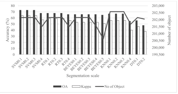
Variable used for object-based classification consisted of 6 bands DII, multi-resolution segmentation with its segmentation scale starts from 0.1, input feature mean and standard deviation, and 5 hybrid classification algorithms. Classification result showed that the accuracy value decreased when increasing segmentation scale applied and also decreasing the numbers of object (Figure 2).
Fig 2. Classification algorithm results with different segmentation scale
Accuracy score and total object decreased according to different segmentation scale application in object-based classification as showed in different phenomena among algorithm of SVM, RT, KNN, BY, and DT. Accuracy and total object with SVM, RT, and KNN algorithms went down in segmentation scale of 0.4. Meanwhile, accuracy and
199,500 200,000 200,500 201,000 201,500 202,000 202,500 203,000 0 10 20 30 40 50 60 70 80 N um ber of obj ect A ccu racy (%) Segmentation scale OA Kappa No of Object
total object with DT algorithm declined in segmenation scale of 0.2. For BY algorithm, total object decreased in segmentation scale of 0.4, but the accuracy was still the same in scale of 0.1-0.3, and the accuracy score and total object went down in scale 0.5. “Overall” Accuracy and Kappa statistic values were obtained from the OBIA classification while for all algorithms of SVM, RT, KNN, Bayesian, and DT were 73% and 0.64, 68% and 0.59, 67% and 0.56, 66% and 0.53, and 56% and 0.46, respectively. Segmentation scale also affected the accuracy values for each classification algorithm. When segmentation scale values from 0.1-0.5 were used, the accuracy values of SVM, RT, and KNN algorithms decreased at the segmentation scale of 0.4, Bayesian algorithm decreased at the segmentation scale of 0.5, and DT algorithm decreased at the segmentation scale of 0.2. thus, the bigger the scale that were used, the less accurate classification result would become which was caused by missing some objects.
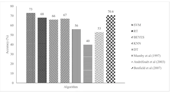
Compared to some previous studies using pixel-based classification technique with MLH algorithm [6], [7], the result of this study indicated a significant increase of classification accuracy values for SVM, RT, Beyesian, KNN, dan DT algorithms (Fig. 3). This study was also showed a higher accuracy value of SVM algorithm compared to an object-based classification technique with fuzzy logic algorithm [17] (Fig. 3). Object-based analyses approach (OBIA) in coral reef mapping conducted by Benfield et al [15] showed an improvement of 24% in the overall accuracy when used object-based classification compared to pixel-based conventional approach. The improvement was resulted due to the OBIA principle that applied multi-resolution segmentation algorithm for categorizing pixel to become similar object into one structure and spectral. Therefore, it was effective to be used in the classification process [16]. SVM algorithm also worked effectively in the type of data with low resolution texture [17]. An object-based classification technique had also the ability to increase object segmentation to accomodate data with high level of heterogenity [18]. Nevertheless, the segmentation used in the big scale could cause less accuracy because OBIA classification implemented multi-resolution segmentation algorithm to classify pixel into similar object in one structural, spectral, and additional spatial information like shape, texture, and contextual connection [16].
Fig 3 Comparison of accuracy overall with some previous studies
Note: Mumby et al [4] and Andréfouët et al [5] used pixel-based classification technique with MLH classification algorithm; Benfield et al [15] uses object-based classification technique with fuzzy logic classification algorithm and contextual editing
Higher object-based accuracy value in this research was also influenced by the used input data. The Landsat 8 OLI which able to penetrate water column was equipped with 4 bands visible rays making this sensor able to produce more DII band composition (6 bands) than that of Landsat ETM+ (3 bands). The more data input number was used in object-based classification process, the more accurate classification result was produced [21].
73 68 66 67 56 40 53 70.6 0 10 20 30 40 50 60 70 80 Algorithm A cc ura cy (%) SVM RT BEYES KNN DT Mumby et al (1997) Andréfouët et al (2003) Benfield et al (2007)
4. Conclusion
Object-based classification of Landsat 8 OLI image was significantly increase classification accuracy for coral reef benthic habitat mapping classification, compare to the pixel-based classification technique with Landsat ETM+ image. Recommended classification algorithm for object-based classification technique was SVM algorithm. References
1. Holden H, LeDrew E. Spectral discrimination of healthy and non-healthy corals based on cluster analysis, principal components analysis, and derivative spectroscopy. Remote Sensing of Environment 1998; 65: 217-24.
2. Hochberg EJ, Atkinson MJ. Spectral discrimination of coral reef benthic communities. Coral Reefs 2000; 19: 164-71.
3. Hochberg EJ, Atkinson MJ. Capabilities of remote sensors to classify coral, algae, and sand as pure and mixed spectra. Remote Sensing of Environment 2003; 85:174-89.
4. Mumby PJ, Green EP, Edwards AJ, Clark CD. Coral reef habitat mapping: how much detail can remote sensing provide? Mar Biol 1997; 130: 193-202.
5. Andrefouoet S, Kramer P, Torres-Pulliza D, Joyce KE, Hochberg EJ, Garza-P‚rez R, Mumby PJ, Reigl B, Yamano H, White.W.H, Zubia M, Brock JC, Phinn SR, Naseer A, Hatcher BG, Muller-Karger FE. Multi-site evaluation of IKONOS data for classification of tropical coral reef environments. Remote Sensing of Environtmen 2003; 88: 128-43.
6. Mumby PJ, Edwards AJ. Mapping marine environments with IKONOS imagery: enhanced spatial resolution can deliver greater thematic accuracy. Remote Sens Environ 2002; 82: 248-57.
7. Malthus TJ, Mumby PJ. Remote sensing of the coastal zone: an overview and priorities for future research. International Journal of Remote Sensing 2003; 24: 2805-15.
8. Wang L, Sousa WP, Gong P. Integration of object-based and pixel-based classification for mapping mangroves with IKONOS imagery. International Journal of Remote Sensing 2004; 25: 5655-68.
9. Lyzenga DR. Remote sensing of bottom reflactance and water attenuation parameters in shallow water using aircraft and Landsat data. Int J Remote Sens 1981; 2: 71-82.
10. Green E, Edwards AJ, Clark C. Remote Sensing Handbook for Tropical Coastal Management. Paris: Unesco Pub.; 2000.
11. Kohler KE, Gill SM. Coral Point Count with Excel extensions (CPCe): A Visual Basic program for the determination of coral and substrate coverage using random point count methodology. Comput Geosci 2006; 32: 1259-69.
12. Clarke KR. Non-parametric multivariate analyses of changes in community structure. Aust J Ecol 1993; 18: 117-43.
13. Mumby PJ, Harborne AR. Development of a systematic classification scheme of marine habitats to facilitate regional management and mapping of Caribbean coral reefs. Biological Conservation 1999; 88: 155-63.
14. Congalton RG, Green K. Assessing the Accuracy of Remotely Sensed Data Principles and Practices. France: CRC Press Taylor & Francis Group; 2008.
15. Benfield SL, Guzman HM, Mair JM, Young JAT. Mapping the distribution of coral reefs and associated sublittoral habitats in Pacific Panama: a comparison of optical satellite sensors and classification methodologies. Int J Remote Sens 2007; 28: 5047-70.
16. Blaschke T. Object based image analysis for remote sensing. ISPRS Journal of Photogrammetry and Remote Sensing 2010; 65: 2-16. 17. Shihavuddin ASM, Gracias N, Garcia R, Gleason A, Gintert B. Image-based coral reef classification and thematic mapping. Remote Sensing
2013; 5:1809-41.
18. Lu D, Weng Q. A survey of image classification methods and techniques for improving classification performance. Int J Remote Sens 2007; 28: 823-70.