Classification of Remote Sensing Images using
Wavelet Based Contourlet Transform and
Accuracy Analysis of Classified Images
M.Emimal
Department ofElectronics and Communication Engineering , PET Engineering College, Anna University, India. Email: [email protected]
Dr.P.Kannan
Department of Electronics and Communication Engineering, PET Engineering College, Anna University, India. Email: [email protected]
---ABSTRACT ---In remote sensing classification of spatial and spectral feature of multispectral images with high accuracy provide greater performance analysis. Wavelet transform is the most preferred transform for classification of both spectral and spatial features. The difficulty present here is the non-availability of directional features. The proposed wavelet based contourlet transform provide salient feature extraction using laplacian pyramid followed by directional filter banks. The extracted features were greatly reduced by using principle component analysis method. By that features the multispectral image has been classified into urban, wasteland, waterbody, hilly region by using fuzzy-c-means clustering algorithm. The wavelet transform is used for low frequency component classification and contourlet transform is used for high frequency component classification on the remote sensing images in the existing method. The aforesaid transforms provide less classification accuracy for remote sensing images. So it is proposed that the wavelet based contourlet transform is to be used for the analysis of both high frequency and low frequency component classification. Hence the proposed method shows that classification accuracy is higher than the existing method.
Keywords - Multispectral Image; Contourlet Transform; Wavelet Transfor; Fuzzy-c-means clustering algorithm &PCA --- --- Date of Submission: March 26, 2018 Date of Acceptance: April 09, 2018 ---
---1. Introduction
T
he remote sensing images also called as radar images. That remote sensing image has little difficulty in the sense of recognizing the image features. The classification of remote sensing images into multiple feature set would dissolve the difficulties present in the visual examination.In remote sensing the extracted features are very useful in many applications. The applications are listed below as in remote sensing [4], Agricultural surveys [5], Environmental monitoring [16], Motion detection [11], Surveillance [2], Medical diagnosis [8] etc.
In classification of remote sensing different methods are used to extract the features set. The methods mentioned below are statistical, structural and spectral based methods. The wavelet transform makes the use of structural based feature extraction. Better performance obtained through giving greater accuracy. But the draw back present here is the non-availability of directional components. The directional features are nothing but the chromaticity of multispectral image. The contourlet transform overcome the problem of non-availability of structural features, but it failed to give directional features for low frequency components. To balance the problems present in both the transforms for image classification, a new method proposed here is the wavelet based contourlet transform. It provides directional features for both slow
and high frequency components with high classification accuracy. This method follows the fuzzy-c-means clustering algorithm for feature extraction, because it provide different degrees of membership to features that are close to more than one cluster. Then the experimental results and data used for this work are discussed.
2. Literature survey
Do,M.N., et al, (2005) proposed a new method for remote sensing image classification. The method is named as contourlet transform. Contourlet transform provide better classification of multispectral images through directional decomposition of images. Thus the contourlet transform characterized as discrete transform. The contourlet transform provide directional resolution only for high frequency images. It is consider to be a major problem of contourlet transform. [9].
Meher et al,(2007) proposed a method called wavelet transform for feature extraction in remote sensing images .Wavelet transform is highly preferred for image classification. Because its contribution in both spatial and spectral features. The improved classification accuracy obtained through wavelet transform but it does not provide directional resolution is consider to be a major disadvantage of this method.[15]
wavelet frame based feature extraction. This method worked same as the wavelet transform method and provide high classification accuracy. But it undergoes two level decomposition that will increase the complexity of the process.[4]
Asli ozdarici ok et al,(2012) disc used about random forest by pixel based approach for remote sensing image classification. The agricultural crop can be classified efficiently with high accuracy by using the proposed method. In this method the parameter selection in classification of remote sensing images greatly reduce the classification accuracy.[6]
Amerald et al,(2013) discussed about unsupervised land cover classification in remote sensing. The land cover classification is obtained through dictionary learning scheme. By using this dictionary learning scheme the features of multispectral images are extracted very easily with high accuracy than the traditional techniques. But the difficulty present in the formation of dictionary matrix.[5]
Deshpande et al (2013) proposed a method texture based association rule mining for medical image classification. The mammograms classified using the texture based rule mining technique with high accuracy. Classification process by this method provide reduced computational time. But some association rules for medical image analysis causes problem in classification.[8]
Hendrich et al, (2014) discussed about camera based PLM classification for sleep analysis performed through robust and sensitive video motion detection. This type of sleep analysis improve the movement image classification. On this motion detection the temporal misalignment is considered to be a greater problem.[11]
Aditi sharma et al,(2016) proposed contrast enhancement technique for remote sensing image classification. This technique worked on the similar basis of discrete wavelet transform and singular value decomposition. The enhanced image gives greater classification accuracy. Low resolution and low contrast images are only preferred to provide high resolution.[1].
3. Proposed Method
The major reason for choosing the Fuzzy-c-means clustering algorithm is that it provide different degrees of membership to features that are close to features that are close to more than one cluster.
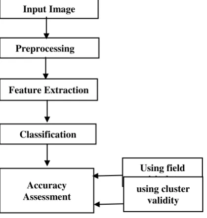
Wavelet transform gives the information about spatial and spectral characteristics of image. The major disadvantage of it is, lack of directional information of a pixel. The proposed Wavelet Based Contourlet Transform using laplacian pyramid method taken after by directional filter banks gives the information about directional characteristics of the pixel. The extracted features are reduced by applying Principle Component Analysis(PCA). From the reduced features the classification of urban, waste land, vegetation, water body, hilly region is obtained using Fuzzy-c-means clustering algorithm.
The input image used here is the multispectral satellite sensor images from Linear Imaging Self Scanner with the size of 256*256.
Fig 1: Block diagram of proposed method
Pre-processing is done on the input image. Data pre-processing describes any type of pre-processing performed on raw data to prepare it for another processing procedure. Data pre-processing transforms the data into a format that will more easily and effectively processed for the purpose of the user for nural network. pre-processing includes Sampling, Transformation, Denoising. Denoising
which removes noise from data. Feature extraction is the special form of
dimensionality reduction. The main goal of feature extraction is to obtain the most relevant information from the original data and represent that information in a lower dimensionality space. In such feature extraction, the extracted features are the spatial frequency features such as urban, waste land, vegetation, water body, hilly region.
These features are used to form the feature vector. These feature vector is used for classification. To obtain the classification without overlapping Fuzzy-c-means algorithm is used. It will assigns different degrees of membership to features that are close to more than one cluster. The main objective of the project is to determine the directional information from multispectral images. The directional information is nothing but a direction of vectors that signifies colour chromaticity. We know that chromaticity is the combination of Hue and Saturation. Hue is specifically used to represent the dominant wavelength or dominant colour in an image. In that way the directional information of the image used to represent the dominant colour that is very helpful in image classification with high accuracy.
Accuracy assessments are performed on classified images to determine the efficiency and accuracy of the
Input Image
Preprocessing
Feature Extraction
Using field visit data Accuracy
Assessment Classification
classification process. The following formula is used for calculating the classification accuracy.
Accuracy = Number correctly identified in ref. plots of a given class/ number actually in that reference class
Internal cluster validity measures are used to compute the classification rate for different techniques. It also used to determine the similarity in cluster.
Field visit data is a measurement that describe ground condition, locational information, time and data.
4. Results and Discussion
The method that proposed here is the wavelet based contourlet transform by using Fuzzy-c-means clustering algorithm.
The major reason for choosing the Fuzzy-c-means clustering algorithm is that it provides different degrees of membership to features that are close to features that are close to more than one cluster.
The input image is the multispectral satellite sensor images from linear imaging self scanner with the size of 256*256 image pixels. The input image is shown in Fig.2
Fig 2 : Input image
The input image is converted into grey scale then the image filtered using median filter. By filtering the image the noise present in the image was reduced considerably . The image is filtered by using median filter in processing in order to generate a output image without noise. Digital images are often corrupted by Impulse noise due to errors generated in noisy sensor, errors that occur in the process of converting signals from analog-to-digital and also errors that are generated in the communication channels.
This error that occurs inevitably alters some of the pixels intensity while some of the pixels remain unchanged. In order to remove impulse noise and enhance the affected image quality, we have studied the median filter and are proposing a method based on an improved median filtering algorithm. This method removes or effectively suppresses the impulse noise in the image whiles preserving the image edges information and enhancing the image quality.In feature extraction the reduction of features obtained by image decomposition ,in which the input image decomposed into low and high frequency band. The low frequency band given to the next stage to get more detailed directional information.
Sub-band coding is a technique for multi resolution analysis. In sub-band coding, an image is decomposed into a set of band limited components, called
sub-bands. It can be proved that we can perfectly reconstruct the original image using the sub-bands. Because the bandwidths of the resulting sub-bands are smaller than the original, it can be down sampled without loss of information.
The high frequency bands given to the directional filter banks. Here the frequency bands also divided into sub bands. The process repeated up to the maximum level of decomposition.
The main advantage of WBCT over PCA is the reconstructed image has the original image size. Contourlet provides a sparse expansion of images having smooth contour and the contourlet transform has a fast implementation based on a Laplacian Pyramid decomposition followed by directional filter banks applied on each band pass sub band.
4.1 Feature Extraction
Feature extraction is the special form of dimensionality reduction.
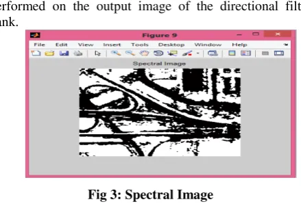
4.1.1 Texture feature based segmentation
The texture feature based segmentation is performed on the output image of the directional filter bank.
Fig 3: Spectral Image
After the image has been segmented into regions of interest image representation and description in suitable form for further processing of an image is required. 4.1.2 Multiple feature learning
The multiple feature learning is simply the representation of segmented image. Representing the image can be done in two ways,
i. Interms of internal characteristics ii. Interms of external characteristics Based on the representation method chosen region can be described. In external characteristics the primary approach to find the shape analysis. In internal characteristics the primary approach is to find the texture an colour. Image texture is characterized by the relationship of the neighboring pixel ignoring their colours.
4.2 Classification
Fig 4 : Classification
Table 1: Classification Table
Features
Colour
specification
Roads
Gray
Grass
Green
Tree
Black
Buildings
White
The above table gives the details about colour or texture specification for distinct regions.
Fig 5: Classification of roads
By using the classification approach the roads were separated out with the specification of gray level texture characteristics and imaged with high accuracy as shown in the above fig.
4.3 Accuracy assessment
Accuracy assessments are performed on classified images to determine the efficiency and accuracy of the classification process. The following formula is used for calculating the classification accuracy.
Accuracy = Number correctly identified in ref.plots of a given class/ number actually in that reference class
The table gives the comparision of accuracy of classified images using existing method with the proposed wavelet based contourlet transform method.
Table 2: Accuracy Comparison Table
Methods Data Base Accuracy
Wavelet LISS-III Images
88.72
NSCT LISS-III Images
89.49
WBCT (Proposed
Method)
SQRL Remote sensing Images
91.45
Wavelet transform is separately performed on the LISS-III data base remote sensing image. Wavelet transform gives the classified image with the accuracy percentage of 88.72. The accuracy obtained here is based on the correctly identified data points of an image.
The non-subsampled contourlet transform is used for classifying the LISS-III data base remote sensing images, which gives the classified image with the accuracy percentage of 89.49. The correctly identified data points in NSCT are higher than the existing wavelet transform.
The method proposed here is the combination of both wavelet and contourlet transform. The accuracy of classified images by using WBCT is 91.45. SQRL data base remote sensing images are taken into account for classification by using the proposed method .
In future the LISS-III data base images will be taken into account for analysing the number of correctly identified data points in the reference class to obtain the higher classification accuracy.
5. Conclusion
cover monitoring. In future work the accuracy will be increased by applying different algorithms and similar performance analyzed with hyperspectral images.
ACKNOWLEDGEMENTS
At first, I thank Lord Almighty to give knowledge to complete the survey. I would like to thank my colleagues, family and friends who encouraged and helped us in preparing this paper.
REFERENCES
[1] Aditsharma,Khunteta (2016),” Satellite Image Contrast and Resolution Enhancement using Discrete Wavelet Transform and Singular Value Decomposition”, International Conference on Emerging Trends in Electrical, Electronics and Sustainable Energy Systems (ICETEESES–16) [2] Ahmad, F., Ahmed, Z., & Najam, A. (2013),
“Soft biometric gender classification using face for real time surveillance in cross dataset environment”. IEEE International Conference on Multi Topic, pp. 131–135.
[3] A. Alaguraja , K. Venkateswaran, N. Kasthuri1, R. (2015), “Performance Comparison of Wavelet and Contourlet Frame Based Features for Improving Classification Accuracy in Remote Sensing Images”, Journal Indian Social Remote Sensing.
[4] Alagu Raja, R. A., Anand, V., Maithani, S., SenthilKumar, A., & AbhaiKumar, V. (2009),
“Wavelet frame based feature extraction technique for improving classification accuracy”, Journal of the Indian Society of Remote Sensing, 37(3), 423–443.
[5] Amelard, R., Wong A., & Clausi, D.A. (2013),
“Unsupervised classification of agricultural land cover using polarimetric synthetic aperture radar via a sparse texture dictionary model”, IEEE International Conference on Geoscience and Remote Sensing symposium, pp. 4383–4386. [6] Asli Ozdarici Ok, Ozlem Akar and Oguz Gungor
(2012)” Evaluation of random forest method for agricultural crop classification”, European Journal of Remote Sensing - 2012, 45: 421-432 doi: 10.5721/EuJRS20124535
[7] Czajkowska, J., Bugdol, M., & Pietka, E. (2012),
“Kernelized fuzzy C- means method and Gaussian mixture model in unsupervised cascade clustering”, Information Technologies in Biomedicine, 7339, 58 –66.
[8] Deshpande, D.S., Rajurkar, A.M., & Manthalkar, R.M. (2013), “Medical image analysis an attempt for mammogram classification using texture based association rule mining”, IEEE National Conference on Computer Vision, Pattern Recognition, Image Processing and Graphics. pp. 1–5.
[9] Do, M. N., & Vetterli, M. (2005), “The contourlet transform: an efficient directional multiresolution image representation”, IEEE
Transactions Image on Processing, 14(12), 2091– 2106
[10] Dos.Santos,J.A.,Penatti,O.A.B.,DaTorres,R.S.,Go sselin,P,PhilippFoliguet,S.,&Falco,A.(2012),
“Improving texture description in remote sensing image multi-scale classification tasks by using visual words”, IEEE International Conference on Pattern Recognition. pp. 3090–3093.
[11] Heinrich, A., Gen, D., Znamenskiy, D., Vink, J. P., & de Haan, G. (2014), “Robust and sensitive video motion detection for sleep analysis”, IEEE Journal on Biomedical and Health Informatics, 18(3), 790– 798.
[12] Halkidi, M., Batistakis, Y., & Vazirgiannis, M. (2002a), “Cluster validity methods: Part-I”, ACM SIGMOD Record, 31(2), 40–45.
[13] Halkidi, M., Batistakis, Y., & Vazirgiannis, M. (2002b), “Clustering validity checking methods: part II”, ACM SIGMOD Record, 31(3), 19–27. [14] Lillesand, M.T., Ralph Kiefer, W., & Jonathan
Chipman, W., (2004), “Remote Sensing and Image Interpretation”, 5th edition, Wiley International edition.
[15] Mioulet, L., Breckon, T.P., Mouton, A., Haichao Liang, & Morie, T. (2013), “Gabor features for real-time road environment classification”, IEEE International Conference on Industrial Technology. pp. 1117– 1121.
[16] Meher, S. K., Uma Shankar, B., & Ghosh, A. (2007), “Wavelet-feature- based classifiers for multispectral remote-sensing images”, IEEE Transactions on Geoscience and Remote Sensing, 45(6), 1881– 1886
AUTHOR DETAILS
M.Emimal (D. Muthuraj) completed B.E (Electronics and Communication has published 2 papers in National and International Conference proceedings. Her area of interest include Electronic System Design, Signal Processing, Image Processing and Digital Communication.