Distributed Locating Algorithm MDS-MAP (LF) Based
on Low-Frequency Signal
Chunyue Zhou1, Tong Xu2, and Hairong Dong3
1
Key Laboratory of Communication & Information System Beijing Jiaotong University, China
2
School of Electronics and Information Engineering Beijing Jiaotong University, China
3
State Key Laboratory of Rail Traffic Control and Safety Beijing Jiaotong University, China
Abstract. The positioning error of distributed MDS-MAP algorithms comes from two aspects: the local positioning error and the position fusion error. In an attempt to improve the positioning result in both local positioning accuracy and global convergence probability, this paper proposes a novel MDS-MAP(LF) algorithm, which uses low frequency signal to measure the inter-sensor distance rather than shortest path algorithms. The proposed MDS-MAP(LF) algorithm leverages the propagation feature of low frequency signal to acquire a more precisely two-hop distance. The simulation and analysis results indicate that the accuracy of local positioning is improved by more than 3%. With the use of cluster expansion, MDS-MAP(LF) also shows a better convergence with comparison to the former classical distributed MDS-MAP algorithm.
Keywords: Wireless Sensor Network, Multi-dimensional Scaling, Low-frequency Signal, Localization.
1.
Introduction
network construction and communication, shows a hot research area of efficient positioning.
The positioning function of wireless sensor network is inspired by the satellite positioning system. However, it is impossible to implement a GPS chip on every wireless sensor node because of the huge cost of the hardware. With the impetus of the users, a lot of wireless sensor network localization algorithms have been proposed in the recent twenty years [2]. These localization algorithms can be divided into two categories according to the distance acquisition process, i.e., range-based algorithms and free algorithms. Table 1 shows four main indicators of a base and range-free algorithms, and the corresponding affecter. In another way, these localization algorithms can be classified as distributed algorithms or centralize algorithms based on their working mode. Table 2 shows the same four indicators and also lists the corresponding affecter of centralized and distributed algorithms, respectively.
Table 1. The comparison of the range-based and range-free algorithms
Range-based Range-free
Accuracy Ranging algorithm Geometric algorithm
Energy consumption Signal transition Instruction execution
Coverage area Signal cover Network topology
Costs Ranging module Execution module
Table 2. The comparison of the centralized and distributed working mode
Centralized mode Distributed mode
Accuracy Data collection Position merging
Energy consumption Signal transition Position merging
Coverage area Network topology Anchor deployment
Costs Central module Anchor equipment
The comparisons in Table 1 and Table 2 present the differences of algorithms clearly. Range-based localization algorithms need to acquire the distances of nodes, and the working principle is relatively concise. RSS-profiling [3, 5], AOA [4] and TDOA [5] are the most currently used techniques which use geometrical and physical principles to ensure the accuracy of positioning. Its disadvantage lies in that the sensor nodes must be equipped with a related hardware. However, the function of received signal strength identification had gained ground quite with the ceaselessly-risen standard of hardware. Range-free localization algorithms come from the research of nodes geometry relationship and the analysis of network topology. Although this kind of algorithms has the advantage that they can work without the ranging module, they are susceptible to accumulative error. Centralized localization algorithms are the most logical method and the centralized mode simplifies the tasks of the sensor nodes greatly. But in a large-scale wireless sensor network, centralized mode may cause much more energy consumption. Distributed localization algorithms are more difficult to design since the complex process of position merging.
explained and a corresponding simulation is given. Section 4 introduces the proposed MDS-MAP(LF) from the aspect of global map merging. It shows the importance of cluster expansion. Section 5 provides the simulation results of MDS-MAP(LF) and analyzes the comparison to existing method. Finally, section 6 concludes the paper.
2.
Related Work
Many localization algorithms have been proposed to locate nodes in wireless sensor networks and describe the use of MDS. Shang et al. [6] proposed MDS-MAP algorithm which uses classical MDS to generate the map nodes used in WSN, and this algorithm was further extended to MDS-MAP(P) [7]. MDS-MAP(D) [8] is an improved method of MDS-MAP(P), it shows a better positioning accuracy by using sensor nodes cluster. Shon et al. [9][10] also proposed cluster-based MDS localization schemes in wireless sensor networks, which typically represent the distributed MDS-MAP approach. Each cluster of the sensor nodes builds the local map using classical MDS algorithm, and then clusters will conduct local map fusion process to shape the entire network location map. The main drawback of these algorithms is that if there are many disjoint clusters exist in the system, then, it will be impossible to map local coordinate system into global coordinate system.
Chen et al. [11] proposed a localization algorithm based on MDS using classified RSSI, it is concluded that the error in the shortest path based distance estimation is high which leads to high localization error. It provides a better accuracy by giving weight to each communication path according to RSSI. However, it still has relatively large estimate error once the sensor nodes lie in the big error area that defined in section 3. Also concerning about the obvious error caused by shortest path algorithms, [12] proposed an improved MDS-based algorithm for localization in WSN, where the distance matrix error is decreased by applying heuristic approach under some ideal assumptions.
Through study and comparison of various positioning schemes in wireless sensor networks, this paper proposed a novel localization method MDS-MAP(LF), it shows a better accuracy in local maps and a better convergence in the process of building global map. The proposed method MDS-MAP(LF) leverages low frequency signal for the inter-sensor distance measure, which improved the small local maps accuracy by realizing the two-hop distance better calculated and enhanced the probability of inter-cluster mergence.
3.
Local Positioning with MDS-MAP(LF)
3.1. Local Positioning Error Analysis of Classical MDS-MAP
range-free mode. These data will be used to construct a global distance matrix for MDS, which is prone to error accumulation. In order to enhance the accuracy of the positioning result, researchers proposed distributed MDS-MAP algorithms, which conduct several classical or improved MDS-MAP algorithms in a local small area. Local maps are then merged together by their common nodes.
It is evident that these algorithms can achieve better accuracy in the uniformly distributed or connectivity well circumstances. However, if the network is sparse or located in an extreme scenario, the accuracy will decline quickly. It is pointed out in [13] that since classical MDS-MAP uses the length of the shortest path such as the Euclidian distance between nodes, classical method is sensitive to the shape of the network. They presented MDS-MAP(I) and demonstrated its accuracy by means of different linear transformations.
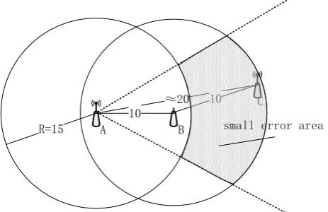
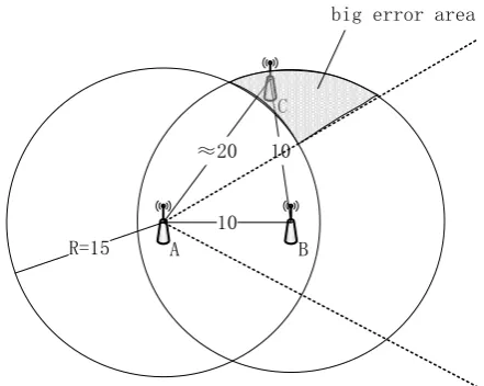
Although MDS-MAP(I)can enhance the positioning accuracy, it is complex in the data calculation process. Here we analyze the shortest path acquisition process in MDS-MAP algorithms and show how errors come. Positioning methods using MDS algorithm usually collect shortest path by Dijkstra or Floyd algorithm, which are not designed for wireless but wired networks. So they perform better in a regular network, but will fail or show big mistakes in a large random distributed network easily. For example, in Figures 1 and 2, three wireless sensor nodes are noted as A, B and C. Each node’s communication radius is 15, and node A has a neighbor B, node B has two neighbors A and C. The distance between neighbor nodes could be acquired precisely by RSS profiling technique.
≈20 10
10
R=15 A B
C
small error area
≈20
10 10
R=15 A B
C
big error area
Fig. 2 Wireless sensor node C belongs to a big error area, the estimated distance between node A and node C is relatively crude
When positioning sensor nodes A, B and C using MDS algorithm, the shortest path between sensor nodes A and C will be estimated by hops since no direct communication exists. If sensor node C belongs to the grey small error area of Figure 1, the estimated shortest path between node A and node C is relatively accurate, but once sensor node C is in the grey big error area shown in Figure 2, the corresponding estimated distance is crude.
In the MDS-MAP algorithms, positioning error of the local area is extremely easy to cause an error accumulation, and this will further limits the final positioning accuracy of the algorithms. Therefore, this paper proposes a range-based method MDS-MAP(LF), which utilizes low frequency signal during the local positioning process. Given the better transmission features of low frequency signal, MDS-MAP(LF) improves the accuracy of local maps. It is based on the realization of two-hop distance valid identification at the same receiving sensitivity, which provides higher accuracy than shortest path algorithms.
3.2. Link Feature of Low-Frequency Signal
In a wireless communication environment, the relationship between received signal strength and distance can be obtained as Friis formula [14], which describes the propagation of a radio signal in free space:
(1)
show the relationship between antenna characteristics and sensor network performance. Letter λdenotes the wavelength of the radio signal and letter L indicates the system loss factor. It shows that, every ten fold decrease in the frequency (also means tenfold increase in the wavelength) of a signal means an increase by 20 dBm in received signal strength. According to the widely used Shadowing link loss model [16, 17, 18], the simplified formula gives a way to estimate the received signal strength:
(2) where Pr(R)dBm denotes the received signal strength at the position, and R is the meter from the emission point, and the unit of power is dBm. Letter A indicates the received signal strength at the position which is one meter from the emission point, and η denotes the path loss factor, which is decided by the actual communication environment. Most currently used wireless sensor nodes or chips, such as the CC24 series and the CC25 series radio transceiver produced by TI Company, work at the 2.4GHz and its transmitted power is usually around 10dBm. The receiving sensitivity of sensor nodes can come to -90dBm.
Here Figure 3 gives a simple simulation to the attenuation of signal intensity using the Shadowing link loss model. We assume the wireless sensor nodes equipped the chip mentioned above and the communication environment is poor by setting ηto 3.5. The frequencies of the radio signal are 2.4GHz and 800MHz. It shows that the higher frequency the radio signal uses, the faster it fades. Figure 4 gives a better explanation of the two kinds of wireless sensor nodes communication coverage, it shows that, with the same transmitted power and receiving sensitivity, radio signal at the frequency of 800MHz has a better transmitted area than the signal at 2.4GHz.When the emission frequency is 2.4GHz, the communication coverage is around 51.801. And as frequency drops to 800MHz, the corresponding coverage is around 97.034.
Fig. 4. Communication radius of wireless sensor nodes with different signal frequency
3.3. Building Local Maps with MDS-MAP(LF)
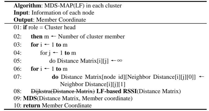
In this subsection, 2-hop clustering are used to build local maps, and each cluster maintains a distance matrix using distance information based on RSSI and the IDs of neighboring nodes received from its own cluster. Table 3 gives a pseudo code running by the cluster head to obtain relative coordinates within a cluster using the MDS algorithm.
Table 3. The pseudo code of MDS-MAP(LF) algorithm in each cluster
Algorithm: MDS-MAP(LF) in each cluster Input: Information of each node
Output: Member Coordinate 01: if role = Cluster head
02: then m ← Number of cluster member 03: for i ← 1 to m
04: for j ← 1 to m
05: do Distance Matrix[i][j] ←∞ 06: for i ← 1 to m
07: do Distance Matrix[node id][Neighbor Distance[i][j][0]] ← Neighbor Distance[i][j][1]
08: Dijkstra(Distance Matrix) LF-based RSSI(Distance Matrix) 09: MDS(Distance Matrix, Member coordinate)
When cluster head performs code from line 1 to line 5, it sets the initial distance between all pairs of nodes to infinite since cluster head received no neighbor distance message. After the preparatory job for building a distance matrix is completed, the cluster head conducts code from line 6 and line 7 to refresh the distance matrix according to the neighbor distance message it received. In line 8, instead of using the shortest path algorithm such as Dijkstra, the MDS-MAP(LF) acquires the 2-hop distance by leveraging the better coverage of low frequency positioning signal. This fills the gap in the distance matrix with a higher accuracy. Then the line 10 is performed to use the MDS algorithm and it results in relative coordinates of all sensor nodes during a cluster. The simulation results of both Dijkstra-based MDS-MAP(D) and LF-based MDS-MAP(LF) are shown in the simulation and result analysis section.
4.
Local Position Merging Using MDS-MAP(LF)
4.1. Merging Principle and Cluster Expansion
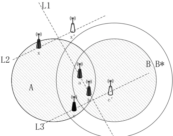
After the establishment of the local maps, wireless sensor network will merge these local clues to build a larger or global map. In this procedure, small local maps can also change their relative coordinates into absolute coordinates when the cluster find an anchor node. The anchor nodes distributed randomly or uniformly can obtain their absolute coordinates precisely by given more resources. In consideration of cost, the amount of anchor nodes should be as small as possible, but this will postpone the convergence rate of global map establishment. One way to solve this problem is to treat the wireless sensor nodes which have changed their relative coordinates into absolute coordinates as new anchors. Therefore these new anchors will provide coordinate information to other sensor nodes.
a x
b
c x’
c’
L1
A
B B*
L2
L3
Fig. 5. Condition of a mergence between two adjacent local maps and effect of cluster expansion
2
3
3
3
1
1
4
1
1
1
2
2
2
B
A
C
D
E
F
G
H
2
3
3
1
4
1
1
1
2
3
2
B
S1
C
D
F
G
H
4
7
1
1
2
1
B
S2
C
F
G
1
2
2
S3
C
F
(a) (c) (b) (d)Fig.6. The global map building process of an inhomogeneous wireless sensor network
S5
2
3
3
3
1
1
4
1
1
2
2
2
2
B
A
C
D
E
F
G
H
2
3
3
1
4
1
1
2
2
3
2
B
S1
C
D
F
G
H
4
7
1
2
2
1
B
S2
C
F
G
1
2
3
S3
C
F
3
S4
F
(b) (c) (f) (a) (d) (e)Fig.7. The global map building process of an inhomogeneous wireless sensor network after a cluster expansion
clusters. This kind of cluster expansion will also be useful to improve the mergence between clusters. Figure 7 gives an example of the effect in the same network with Figure 6, the only difference is the common node amount of cluster B and cluster C, which comes to two. We also choose cluster A as the start point in Figure 7(a), the following steps Figure 7(b) and Figure7(c) are quite same with the corresponding steps in Figure6. When cluster S3 begins to diffusion its area in Figure 7(d), it can find an available direction and keep the mergence going. Finally through Figure 7(e) and Figure 7(f), the cluster S5 will have a global map and the result will be the same when we choose the other clusters as the beginning point.
4.2. Conduct Local Position Merging Using MDS-MAP(LF)
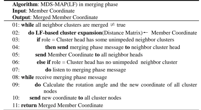
After the local map of a cluster is calculated by the cluster head, each cluster head node begins to contact the neighbor cluster and tries to participate in a possible merging. Table 4 shows the pseudo code for the merging step in MDS-MAP(LF).
Table 4. The pseudo code of MDS-MAP(LF) algorithm
Algorithm: MDS-MAP(LF) in merging phase Input: Member Coordinate
Output: Merged Member Coordinate
01: while all neighbor clusters are merged ≠ true
02: do LF-based cluster expansion(Distance Matrix)← Member Coordinate 03: if role = Cluster head has some unimpeded neighbor clusters
04: then send merging phase message to neighbor cluster head 05: send Member Coordinate to all neighbor heads
06: else if role = Cluster head has no unimpeded neighbor cluster 07: do listen to merging phase message
08: while receive merging phase message
09: do Calculate the rotation angle and the new coordinate of all cluster nodes
10: send new coordinate to all cluster nodes 11: return Merged Member Coordinate
returns the merged coordinate of all cluster nodes. The influence of LF-based cluster expansion is shown in the simulation and result analysis section.
5.
Simulation and Result Analysis
5.1. Local Positioning Accuracy
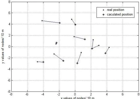
By using low frequency signal in the process of positioning, wireless sensor nodes will find more neighbors, such as sensor node A could find sensor node C in Figure 1. It will provide more accurate data compared to the estimated result acquired by shortest path algorithms. In order to give a further reflection of accuracy improvement, this paper compares the MDS-MAP(LF)with the distributed MDS-MAP(D), which uses classical MDS algorithms to build the small local maps. We conduct a simulation for the local positioning process of MDS-MAP(D) and MDS-MAP(LF) respectively in Figure 8 and Figure 9.
It is assumed that the communication radius of wireless sensor nodes is 40 meters, and the actual location of the 100 nodes is generated randomly in a 320 meters * 320 meters area, this means the each node should have nearly 5 neighbor nodes by mathematical calculation. Figure 8 shows a local positioning map generated by MDS-MAP(D) algorithm. There are 10 nodes in this local map, and each node’s real position is denoted by a solid dot, the corresponding calculated position is mark by an asterisk. Also the positioning errors are shown as the length of the lines which connect the solid dots and the asterisks.
Fig. 8. Local positioning map of 10 sensor nodes acquired by MDS-MAP(D)
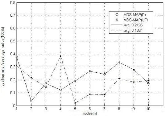
with Figure 8 and also denoted by a solid dot. The corresponding calculated position is mark by an asterisk. Positioning errors are shown as the length of the lines which connect the solid dots and the asterisks. By comparing these two pictures, we can find that, the positioning error of many nodes decreased as the line between the solid dot and asterisk is shorter in Figure 9, this demonstrates a better accuracy of two-hop distance valid identification realized by low frequency signal compared to the estimated value calculated by shortest path algorithms.
Fig. 9. Local positioning map of 10 sensor nodes acquired by MDS-MAP(LF)
The comparison of MDS-MAP(D) and MDS-MAP(LF) in term of local positioning error is shown in Figure 10. It depicts the percentage of positioning error for each of the 10 sensor nodes mentioned in Figure 8 and Figure 9, and shows the average error of both localization algorithms. Using MDS-MAP(LF), the calculated position is more accurate for most wireless sensor nodes except the nodes 2, 4 and 10. The average error of MDS-MAP(LF) is 18.34%, which is nearly four percentage points lower than the average error of MDS-MAP(D).
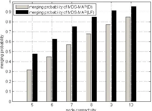
5.2. Local Position Merging Probability
Given a better coverage of each cluster, MDS-MAP(LF) performs a higher merging probability based on the mathematical derivation. Based on this analysis, Figure 11 shows the successful merging probability of any adjacent clusters in some relatively low connectivity scenarios.
While the node connectivity is 5, the merging probability of MDS-MAP(D) shown as the grey rectangle is just 31.88%, and the corresponding value of MDS-MAP(LF) shown as the black rectangle is 47.83%. And while the node connectivity comes to 10, each algorithm performs a bigger merging probability. The MDS-MAP(D) shows 84.62% and the MDS-MAP(LF) shows 95.42%. This suggests that the lower node connectivity the wireless sensor network is given, the smaller merging probability a cluster acquired. It also indicates that the influence of cluster expansion proposed by MDS-MAP(LF) is more remarkable in a sparse wireless sensor network. By enhancing the merging probability of adjacent clusters, MDS-MAP(LF) performs a better convergence during the local position merging process.
6.
Conclusion
The positioning error of distributed MDS-MAP algorithms comes from two aspects: the local positioning error and the position merging error. The cause of local positioning error is the crude two-hop distance estimated by the shortest path algorithms, which are not designed for wireless but wired networks. The convergence process of local clusters can lead to a large position merging error, especially in the inhomogeneous network. This paper proposed a novel MDS-MAP(LF) algorithm, which uses low frequency signal for the inter-sensor distance measure rather than shortest path algorithms. The simulation result shows that the accuracy of local positioning map has increased by more than 3% comparing with the distributed MDS-MAP algorithm. In terms of global map building process, MDS-MAP(LF) algorithm gives a better vision to local clusters, which improves the complete convergence probability. The future work should be focused on an improved algorithm of cluster expansion, which may achieve the function of abnormal nodes localization and exclusion.
Acknowledgment. The authors wish to acknowledge the National Natural Science Foundation of China (No. 61322307) for their support in funding this work.
References
1. Younis, M., Akkaya, K.: Strategies and techniques for node placement in wireless sensor networks: A survey. Ad Hoc Networks, Vol.6, No. 4, 621-655. (2008)
2. Mao, G., Fidan, B., Anderson, B.D.O.: Wireless sensor network localization techniques. Computer Networks, Vol. 51, 2529-2553. (2007)
3. Min, AW., Shin, KG.: An Optimal Sensing Framework Based on Spatial RSS-profile in Cognitive Radio Networks. IN Proc. SECON. pp. 207-215.Piscataway (June 2009)
4. Boushaba, M., Hafid, A., Benslimane, A.: High accuracy localization method using AoA in sensor networks. Computer Networks, Vol. 53, No. 18, 3076-3088. (2009)
5. Desai, P., Baine, N., Rattan, K.: Fusion of RSSI and TDoA Measurements from Wireless Sensor Network for Robust and Accurate Indoor Localization. International Technical Meeting of the Institute of Navigation. pp. 223-230. San Diego (January 2011)
6. Shang, Y., Ruml, W., Zhang, Y., Fromherz, M.: Localization from connectivity in sensor networks. IEEE Transaction on parallel and distributed system, Vol. 15, No. 11, 961-974. (2004)
7. Shang, Y., Ruml, W.: Improved MDS-based localization. IEEE INFOCOM, Vol. 4, 2640-2651. (2004)
8. Ma, Z., Liu, Y., Shen, B.: Distributed locating algorithm for wireless sensor network-MDS-MAP(D), Journal on Communications, Vol.29, No. 6, 57-62. (2008)
9. Shon, M., Choi, W., Choo, H.: A cluster-based MDS scheme for range-free localization in wireless sensor networks. International Conference on Cyber-Enabled Distributed Computing and Knowledge Discovery. pp. 42-47. Huangshan (October 2010)
10. Shon, M., Jo, M., Choo, H.: An interactive cluster-based MDS localization scheme for multimedia information in wireless sensor networks. Computer Communications, Vol. 35, No. 15, 1921-1929. (2012)
12. Stojkoska, B.R., Kirandziska, V.: Improved MDS-based algorithm for nodes localization in wireless sensor networks. pp. 608-613. Zagreb (July 2013)
13. Namin, P.H., Tinati, M.A.: Localization of Irregular Wireless Sensor Networks Based on Multidimensional Scaling, IEEE Computer Society, Vol. 1, 79-83. (2009)
14. Ghobad, P.C., de Moraes, R.M.: BER Analysis with an Appropriate Friis Formula for Multi-hop ALOHA Dense Ad Hoc Networks. Vehicular Technology Conference. pp. 1-5. Quebec City (September 2012)
15. Arroyo-Valles, R., Madrono-Prados, C., Quevedo-Teruel, O.: Influence of the antenna characteristics on the sensor network performance.2011 8th International Symposium on Wireless Communication Systems (ISWCS). pp. 226-230. Aachen (November 2011) 16. Chan, Y.W.E., Cam, C.L., Boon-Hee Soong.: Comparative study of correlated shadowing
loss model for wireless sensor networks. 2013 9th International Conference on Information, Communications and Signal Processing (ICICS). pp. 1-5. Tainan ( December 2013)
17. Miranda, J., Abrishambaf, R., Gomes, T., Goncalves, P.: Path Loss Exponent Analysis in Wireless Sensor Networks: Experimental Evaluation. 2013 11th IEEE International Conference on Industrial Informatics (INDIN). pp. 54-58. Bochum (July 2013)
18. Chrysikos, T., Geogrogoulos, G., Kotsopoulos, S.: Impact of shadowing on wireless channel characterization for a public indoor commercial topology at 2.4 GHz. 2010 International Congress on Ultra-Modern Telecommunications and Control Systems and Workshops (ICUMT).pp. 281-286. Moscow (October 2010)
19. Yan GX., Xu J.: A Clustering Algorithm in Wireless Networks. 2008. MMIT '08. International Conference on Multi Media and Information Technology. pp. 629-632. Three Gorges (December 2008)
20. Chen, L., Zhao, BH.: An Interference Free Data Aggregation Protocol for Clustered Wireless Sensor Networks. 2008. FGCN '08. Second International Conference on Future Generation Communication and Networking. pp. 35-39. Hainan Island (December 2008)
21. Nguyen, TD., Nguyen, TM, QuocBao, VN.: Cooperative communication techniques for cluster size expansion in cluster based Wireless Sensor Network. 2012 International Conference on Advanced Technologies for Communications (ATC).Pp. 146-151. Hanoi (October 2012)
Chunyue Zhou completed her BSc in Information Engineering, MSc and PhD in Communication &Information Systems from the School of Electronic and Information Engineering, University of Beijing Jiaotong, China. She is now a Senior Engineer and her research interests include the next generation Internet and information security.
Tong Xu received his bachelor’s degree in Communication Engineering from the School of Electronic and Information Engineering, University of Beijing Jiaotong, China. He is now a Ph.D. Candidate at the National Engineering Laboratory for Next Generation Internet Interconnection Devices since 2014. His main research interests lie in the area of next generation Internet with emphasis on software defined networking, wireless sensor networking and network security. He is the corresponding author of this paper.
Society, the chair of Technical Committee on Railroad Systems and Applications, and the vice general secretary of Chinese Automation Congress. Her research interests include intelligent control systems, cooperative control, parallel control, stability and robustness of complex control systems.