Visual Place Recognition under Severe
Viewpoint and Appearance Changes
Ahmad Khaliq
School of Computer Science and Electronic Engineering
University of Essex
The thesis is submitted for the degree of
Master by Dissertation
Declaration
I hereby declare that except where specific reference is made to the work of others, the contents of this dissertation are original and have not been submitted in whole or in part for consideration for any other degree or qualification in this, or any other university. This dissertation is my own work and contains nothing which is the outcome of work done in collaboration with others, except as specified in the text and Acknowledgements.
Ahmad Khaliq January 2020
Acknowledgements
First and foremost, I would like to thank the God Almighty for giving me the strength, ability and opportunity to undertake this study and complete it successfully. Without His blessings, it would not have been possible to conduct this extensive research work.
My heartiest gratitude to Prof. Klaus McDonald-Maier for offering me to pursue MSc by Dissertation under his supervision. It can be very challenging to take an international student with a different cultural background and way of study. However, undertaking the MSD study under his guidance has been truly a life changing experience. I would like to say thank you to Dr. Shoaib Ehsan for his continuous guidance and support during the whole period of study. His excellent research skills and constructive criticism, coupled with the deep insightful discussions have always been a great source of motivation. During my MSD, he was very generous and put-in a lot of efforts and endless patience to co-supervise me. I have learnt the art to go from idea-to-execution in an efficient manner resulting in novel research contributions.
I extend my gratitude to Prof. Michael Milford, Associate Professor at Queensland University of Technology, Australia, for providing me with his invaluable feedback on my research in all the jointly collaborated works. His survey paper in the field of visual place recognition served as an initial motivation to choose my MSD topic of research in the field of robotic vision. Furthermore, I am very grateful to his student Dr. Zetao Chen, who is currently a postdoctoral research fellow in ETH Zurich for providing me the benchmark datasets and their evaluated results. It helped me in carrying out a fair comparison of my proposed research contributions with state-of-the-art algorithms.
Many thanks to Prof. Dongbing Gu and Dr. Amit Singh, member of my supervisory panel for their encouragement, thoughtful guidance, critical comments and valuable feedbacks. They all were very helpful and provided me with their assistance throughout my research. During my MSD, I had the opportunity to work on a European funded INTERREG V 2 SEAS INCASE project. Under the guidance of Prof. Klaus McDonald-Maier and Prof. Dongbing Gu, I have gained experience in Industry 4.0 which resulted into novel research contributions while collaborating with INCASE project partners including KU Leuven, Technologie campus Gent, Belgium. As a member of the INCASE team, I really enjoyed
vi
working with postdoctoral research fellow Dr. Sangeet Saha. I’m very grateful for his help, advices and really enjoyed the time we have spent together in the lab and attending INCASE meetings held in France and Belgium.
My colleagues in the EIS lab have made my MSc by research a very enjoyable journey. I would like to thank all my office colleagues which include Mubariz Zaffar, Dr. Sangeet Saha, Zeba Khanam, Dr. Bilal Aslam, Somdip Dey, Bina Bhatt, Anca Sticlaru, Grigorios Kalliatakis and many more. I want to thank to Philip George for his administrative support within our EIS lab. I am grateful to all of them - for keeping an atmosphere of friendship and the warmth they extended to me and for always making me feel so welcome. From this experience, I have learnt different culture and will always remember the time spent in enjoying food while having fun talks.
One of my closest friend; research officer and postgraduate research student Mubariz Zaffar, I especially would like to mention him here. The friendship we have built during this whole period, I really appreciate your support. You’ve always given me your honest opinion and stood by me whenever required. I will never forget the time we have spent staying late at office which resulted into some excellent joint research contributions. I really enjoyed your company and wish you a very bright future ahead.
Finishing this without acknowledging my family support is not conceivable. Coming all over from Pakistan to United Kingdom to pursue postgraduate research was never an easy journey. I want to express my heartfelt appreciation to my lovely mother and father for their great patience, for believing in me and encouraging me to follow my dream. Without the prayer of my parents, I could not have finished this work. I can just say thanks for everything and pray that may God give them long lives and keep them well in body and spirit.
Abstract
Over the last decade, the eagerness of the robotic and computer vision research communities unfolded extensive advancements in long-term robotic vision. Visual localization is the constituent of this active research domain; an ability of an object to correctly localize itself while mapping the environment simultaneously, technically termed as Simultaneous Localization and Mapping (SLAM).
Visual Place Recognition (VPR), a core component of SLAM is a well-known paradigm. In layman terms, at a certain place/location within an environment, a robot needs to decide whether it’s the same place experienced before? Visual Place Recognition utilizing Con-volutional Neural Networks (CNNs) has made a major contribution in the last few years. However, the image retrieval-based VPR becomes more challenging when the same places experience strong viewpoint and seasonal transitions. This thesis concentrates on improving the retrieval performance of VPR system, generally targeting the place correspondence.
Despite the remarkable performances of state-of-the-art deep CNNs for VPR, the sig-nificant computation- and memory-overhead limit their practical deployment for resource constrained mobile robots. This thesis investigates the utility of shallow CNNs for power-efficient VPR applications. The proposed VPR frameworks focus on novel image regions that can contribute in recognizing places under dubious environment and viewpoint variations.
Employing challenging place recognition benchmark datasets, this thesis further illus-trates and evaluates the robustness of shallow CNN-based regional features against viewpoint and appearance changes coupled with dynamic instances, such as pedestrians, vehicles etc. Finally, the presented computation-efficient and light-weight VPR methodologies have shown boostup in matching performance in terms of Area under Precision-Recall curves (AUC-PR curves) over state-of-the-art deep neural network based place recognition and SLAM algorithms.
Contents
List of Figures xi List of Tables xv Abbreviations xvii 1 Introduction 1 1.1 Background . . . 11.2 Simultaneous Localization and Mapping (SLAM) . . . 3
1.2.1 Mapping . . . 3
1.2.2 Localization . . . 4
1.3 Visual Place Recognition (VPR) . . . 4
1.4 Problem Statement and Challenges . . . 6
1.5 Thesis Contributions . . . 7
1.6 Thesis Structure . . . 8
1.7 List of Publications . . . 9
2 Literature Review 11 2.1 Overview . . . 11
2.2 Visual Place Recognition Methodologies . . . 13
2.2.1 Approaches based on Local features . . . 13
2.2.2 Approaches based on Global features . . . 15
2.2.3 Approaches based on a Combination of Local and Global features . 16 2.2.4 Approaches based on 3D information . . . 17
2.2.5 Approaches based on Deep CNN features . . . 18
2.2.6 Image Matching . . . 22
2.3 State-of-the-Art Visual Place Recognition techniques . . . 24
2.4 Benchmark Visual Place Recognition Datasets . . . 26
x Contents
2.6 Summary . . . 30
3 Shallow CNN-based Regional-approach for Visual Place Recognition 33 3.1 Introduction . . . 33
3.2 Proposed Region-VLAD VPR framework . . . 35
3.2.1 Stacking of Convolutional Activations for making Descriptors . . . 35
3.2.2 Identification of Regions of Interest . . . 36
3.2.3 Regional Vocabulary and Extraction of VLAD for Image Matching 38 3.3 Setup and Implementation Details . . . 41
3.4 Results and Analysis . . . 43
3.4.1 Comparison Techniques . . . 44
3.4.2 Precision Recall Characteristics . . . 46
3.4.3 Receiver Operating Characteristic (ROC) curves and Matching Score Thresholding . . . 54
3.4.4 Performance Analysis . . . 56
3.5 Summary . . . 60
4 Context-Aware Attention framework for Visual Place Recognition 65 4.1 Introduction . . . 65
4.2 Proposed Multi-Layer Region-VLAD VPR framework . . . 68
4.2.1 Stacking of Convolutional Activations for making Descriptors . . . 68
4.2.2 Identification of Context Aware Regional Attentions . . . 68
4.2.3 Attentions-based Vocabulary and Extraction of VLAD for Image Matching . . . 69
4.3 Setup and Implementation details . . . 71
4.4 Results and Analysis . . . 73
4.4.1 Comparison Techniques . . . 73
4.4.2 Precision Recall Characteristics . . . 74
4.5 Summary . . . 77
5 Conclusions and Future Directions 81 5.1 Contributions Summary . . . 81
5.2 Future Directions . . . 82
List of Figures
1.1 Examples of human cars with inbuilt self-driven capabilities. . . 2 1.2 An occupancy grid map; the world is subdivided into discrete regions. Black
and white regions indicate the presence of obstacles and explored areas. Grey regions are not yet observed. (Image taken from [1]) . . . 4 1.3 A visual place recognition system takes query images as an input and returns
the visually similar database images for localization. . . 5 1.4 A generic visual place recognition system must be able to successfully
recognize (a) the correct place irrespective of the visual changes and (b) reject the visually similar but geographically different places (Image taken from [2]). . . 6
2.1 Incoming visual data is processed by the image processing module and its description is stored in the place mapping framework. The belief generation module takes the decision by matching the current location with the stored places. . . 12 2.2 Example of local and global descriptors for place recognition (Image taken
from [2]). . . 14 2.3 K-means clustering of the feature descriptors with each cluster center treated
as a visual word. . . 15 2.4 Convolutional Neural Network (CNN) with the NetVLAD layer (image taken
from [3]). . . 19 2.5 Images from the spring season are matched against the winter season. Feature
heat maps in the first and second columns are taken from HybridNet [4]. The third column exhibits the heat maps of CaffeNet. . . 20 2.6 A place recognition system utilising deep VGG-16 pre-trained on ImageNet
under strong viewpoint and moderate conditional changes (Image taken from [5]). . . 20
xii List of Figures 2.7 A deep neural network based place recognition framework focusing on
context-flexible attentions. Two exemplars with their heat maps are shown here (image taken from [6]). . . 21 2.8 VPR using single image matching. . . 23 2.9 VPR using sequence-based image matching. . . 25 2.10 Hand-crafted and neural network-based contemporary VPR techniques. . . 26 2.11 Examples of 6-DOF (degree of freedom) and lateral viewpoint variations.
(image taken from [7]) . . . 26 2.12 Strong viewpoint and conditional variations can be observed across the same
places. Left and right column frames of each dataset are taken from the test and reference traverses. . . 28
3.1 For a query image (a), the proposed Region-VLAD approach successfully retrieves the correct image (c) from a stored image database under significant viewpoint- and condition-variation. (b) and (d) represent their CNN based meaningful regions identified by our proposed methodology. . . 35 3.2 Workflow of the proposed VPR framework is shown here. Test/reference
images are fed into the CNN model, Region-of-Interests (ROIs) are identified across all the feature maps of the convolution layer and their compact VLAD representation is stored for image matching. . . 36 3.3 Sample images of top 50, 200 and 400 Regions-Of-Interest (ROIs) identified
by the proposed approach. . . 37 3.4 Employing two features mapsM1andM2, sample images of ROIs identified
by Region-VLAD and Cross-Region-BoW [5] are shown here. Note that feature maps (1st column) illustrate the intensities ofaactivations. However, regardless of the intensity, each identified Gh region per feature map for Region-VLAD (2nd column) is indicated with a different color i.e. 36 and 40 colored regions for feature mapM1andM2. For Cross-Region-BoW (3rd column), all the regions are denoted as yellow patterns i.e. 6 and 4 ROIs for
M1andM2feature maps. . . 39 3.5 Sample images of ROIs identified with Cross-BoW [5] and
Region-VLAD are shown here. Our regional approach subdivides each image into large number of most contributing regional blocks. . . 40 3.6 First and second column present Query247 images [8]. Images in the third
column are taken from the suburban datasets collected fromMapillarywhere forth column showcases St.lucia traverses [4]. . . 41
List of Figures xiii
3.7 Pictorial view of the regional vocabulary illustrating mapping of the ROIs-Descriptors of test and reference images for VLAD retrieval. . . 42 3.8 Matching times for 1 test VLAD against 750 reference VLADs are presented. 44 3.9 AUC-PR performance and retrieval time of Region-VLAD are reported while
adding more images in T test and R reference traverses. . . 45 3.10 Top: PR-curves of our proposed Region-VLAD approach. Middle:
Cross-Region-BoW [5] employed on AlexNet365 and HybridNet with VLAD and BoW encodings. Bottom: Comparison with state-of-the-art VPR approaches 47 3.11 Three different places (a), (c) and (d) ofBerlin Kudammexhibiting a similar
scene. (b) represents the novel regions identified from (a) using our region finding approach employed on AlexNet365. . . 49 3.12 Top: PR-curves of our proposed Region-VLAD approach. Middle:
Cross-Region-BoW [5] employed on AlexNet365 and HybridNet with VLAD and BoW encodings. Bottom: Comparison with state-of-the-art VPR approaches. 50 3.13 Top: PR-curves of our proposed Region-VLAD approach. Middle:
Cross-Region-BoW [5] employed on AlexNet365 and HybridNet with VLAD and BoW encodings. Bottom: Comparison with state-of-the-art VPR approaches. 51 3.14 Top: PR-curves of our proposed Region-VLAD approach. Middle:
Cross-Region-BoW [5] employed on AlexNet365 and HybridNet with VLAD and BoW encodings. Bottom: Comparison with state-of-the-art VPR approaches. 52 3.15 Top: PR-curves of our proposed Region-VLAD approach. Middle:
Cross-Region-BoW [5] employed on AlexNet and HybridNet with VLAD and BoW encodings. Bottom: Comparison with state-of-the-art VPR approaches. 54 3.16 ROC curves for datasets with true-negative scenarios for Region-VLAD and
Cross-Region-BoW [5]. . . 57 3.17 Matching scores thresholding using Region-VLAD with true-negative cases.
Each row is associated with a dataset; left graph presents TP, FP, TN and FN before thresholding and right side graph showcases the change upon thresholding. . . 58 3.18 Sample images of identified ROIs using our Region-VLAD approach
em-ployed on AlexNet365 and HybridNet. . . 61 3.19 Correctly retrieved places with the proposed Region-VLAD framework. . . 62 3.20 Incorrectly retrieved places with the proposed Region-VLAD framework. . 63
4.1 Three exemplars are shown against which (a), (b) and (c) represent their identified novel multi-layer fused regions. . . 66
xiv List of Figures 4.2 Images are fed into the CNN model. The identified attentions from
multi-ple convolutional layers are fused and mapped on a dictionary for VLAD retrieval. . . 67 4.3 Fused multi-scale attentions captured under strong conditional changes
cou-pled with dynamic instance experienced by the place (a) and (b) under different times of the year . . . 70 4.4 Area under Precision-Recall curves for St.Luciadataset on contemporary
VPR techniques. . . 75 4.5 Area under Precision-Recall curves for Synthesized Nordland dataset on
contemporary VPR techniques. . . 76 4.6 Area under Precision-Recall curves forSPEDTestdataset on contemporary
VPR techniques. . . 77 4.7 Sample context-based regional attentions identified by Context Flexible
List of Tables
2.1 Computational power requirements (taken from [7]) . . . 27 2.2 Benchmark visual place recognition datasets employed in Chapter 3 . . . . 29 2.3 Benchmark visual place recognition datasets employed in Chapter 4 . . . . 29
3.1 Runtime performance comparison of our proposed Region-VLAD with Cross-Region-BoW [5], NetVLAD [3], RMAC [10] and SPP [4]. . . 46 3.2 AUC PR-curves of Region-VLAD and Cross-Region-BoW [5] on the
bench-mark datasets. . . 53 3.3 AUC ROC-curves of Region-VLAD and Cross-Region-BoW [5] on the
benchmark datasets with reduced reference traverses . . . 55
Abbreviations
AMOS Archive o f Many Outdoor Scenes
ASMK Aggregtaed Selective Match Kernels
BRISK Binary Robust Invariant Scalable Keypoints
BoW Bag o f Words
CNNs Convolutional Neural Networks
FABMAP Fast Appearance Based Mapping
FAST Features f rom Accelerated Segment Test
GLD Google Landmark Dataset
GPS Global Positioning System
HCT Hull Census Trans f orm
LBP Local Binary Pattern
LDB Local Di f f erence Binary
PCA Principal Component Analysis
RMAC Regional Maximum Activations o f Convolutions
SEQSLAM Sequence SLAM
SIFT Scale Invariant Feature Trans f orm
SLAM Simultaneous Localization and Mapping
xviii Abbreviations
SPP Spatial Pyramid Pooling
SU RF Speeded−U p Robust Feature
SV M Support Vector Machine
V GG Visual Geometry Group
V LAD Vector o f Locally Aggregated Descriptors
Chapter 1
Introduction
Over the last few years, significant improvements have been made in autonomous driving and robotic vision [11]. For a safe and continuous operation, a vigorous navigation system is indispensable. To correctly localize within an environment, the object needs to build a map of its surroundings, technically termed as Simultaneous Localization and Mapping. Visual Place Recognition is a prime component of SLAM; a system which can decide whether the place has previously been visited or not, also termed as a loop-closure detection. The aim of this thesis is to improve visual place recognition for battery-operated mobile robots under changing conditions, including appearance and viewpoints variations coupled with dynamic instances. This thesis presents methodologies that increase the robustness of SLAM by improving the performance of visual place recognition at low memory and computation cost. Our proposed frameworks allow mobile robots to globally localize by identifying places which have been previously visited given changed conditions and viewpoints.
This chapter discusses the main topic of this thesis; visual place recognition under severe viewpoint and appearance changes. It starts with the background in Section 1.1, followed up with the introduction of SLAM in Section 1.2. Section 1.3 establishes the link between VPR and visual-SLAM. Section 1.4 highlights the challenges in VPR along with the thesis objectives and contributions are presented in Section 1.5. Section 1.6 outlines the dissertation organization and research contributions made during this research are listed in Section 1.7.
1.1
Background
Over the past few decades, autonomous vehicles and intelligent mobile robots have attracted increased level of attention from the research communities and industrial organizations [12][13]. In 2005, American Department of Defense, DARPA (Defense Advanced Research Projects Agency) organized a vehicle Grand challenge to promote the development of
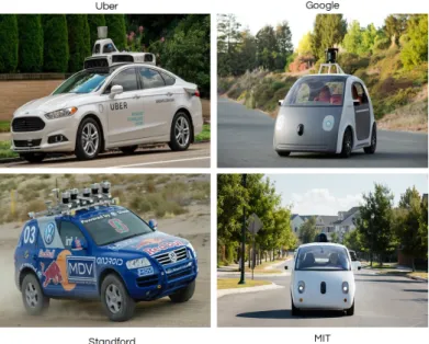
2 Introduction autonomous vehicles. The challenge winner STANDEY, an autonomous car created by Standford University, USA had employed SLAM as part of its autonomous driving system. It attracted many top level research organizations such as, Google which started its self-driving car project in 2009 and with real-time autonomously driven 1.5 million miles, it is presently steering through the street of Mountain View, California. The first Google self driving car was released in 2014, followed up by many other companies and institutions including Baidu, MIT, BMW and Uber as shown in Fig. 1.1. A number of autonomous mobile systems have been demonstrated including Mars rover car (2014) and Google self driving vehicle (2015).
Fig. 1.1 Examples of human cars with inbuilt self-driven capabilities.
Encouraged by the recent success of autonomous vehicles, some indoor autonomous robotic experiments claim that with minor occasional human interventions, the robot can run autonomously for months using a visual sensor such as, a camera [14][15]. However, real world outdoor scenes are quite challenging and a long-term autonomous navigation system under such extreme environmental changes is still a big question that needs to be answered. Visual information is susceptible to appearance changes because the same place can undergo drastic environmental variations and perceptual changes due to the seasonal, weather and illumination variations. Most localization and navigation systems match places based on the captured RGB information, therefore, such appearance changes cast a severe challenge. Intelligent vehicles or mobile robots comprise the fundamental systems including navigation, localization and perception. Localization is the core component that leads to successful accomplishment of other tasks because by determining the current position/location, path
1.2 Simultaneous Localization and Mapping (SLAM) 3
planning can be performed. Therefore, accuracy of the localization system is directly associated with autonomous vehicles or mobile robots.
Localization can be accomplished through visual place recognition, which tries to retrieve a place from the previously visited places. This dissertation focuses on lightweight visual place recognition with an ultimate goal to localize at low memory and time cost. We expect resource-constraint mobile robots to benefit from this work.
1.2
Simultaneous Localization and Mapping (SLAM)
To recognize a previously visited place, the system needs a map to perform robotic local-ization. Building such maps of the surrounding environment for localization is termed as Simultaneous Localization and Mapping (SLAM). In the past few decades, SLAM is a very active area of research among the robotic and computer vision communities. It consists of following components:
1.2.1
Mapping
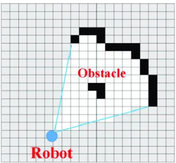
It’s the process of internally creating and storing the outside world representation. The generation of world maps can vary from the type of environment and sensory information [16]. For instance, occupancy grid maps [17] subdivides the world into evenly spaced discrete regions or cells, as shown in Fig. 1.2. Each cell is assumed to be occupied or free, named as occupancy grid maps. Few assumptions are made for occupancy grid maps; each cell is either free or occupied and independent upon each other. Given all the past information and states, each region has an obstacle probability. Those regions which are nether occupied nor explored, they have assigned with 0.5 obstacle probability. In dense indoor environments, such occupancy-based grid maps fit perfectly as they can easily be constructed from laser-or sonar-based inflaser-ormation but require significant memlaser-ory resources. These maps have been widely employed in obstacle avoidance algorithms including potential field [18]. In comparison, feature maps are quite compact, sparse and consist of distinctive landmarks with their coordinates. They are suitable in outdoor environments with information about the landmarks obtained from the visual sensors. Pose graphs [19] are another form of maps that graphically defines the robot trajectory. The nodes orientation describe the robot’s pose and position. Edges describe the spatial connection between the poses, can be used for loop closure.
4 Introduction
Fig. 1.2 An occupancy grid map; the world is subdivided into discrete regions. Black and white regions indicate the presence of obstacles and explored areas. Grey regions are not yet observed. (Image taken from [1])
1.2.2
Localization
Employing visual sensors, Localization is the process of tracking the position of robot within the map. This module processes the incoming visual data and outputs a belief about the current place within the map. Using the belief, system decides whether the presently encountered place is previously seen or a new place. Two similar places usually implies the same location. However, this supposition does not work when there are significant weather and illumination changes which might cause the robot to incorrectly localization within the map.
Localization can either be local or global. In global localization, the robot assumes that there is no prior knowledge and can move anywhere within the map. Such re-localization of the robot using visual information and map give rise to kidnapped robot problem. Envi-ronments within which the places are quite similar, global localization is difficult to achieve. However, the robot generally has some prior information of its current pose and map; known as local localization [20]. The prior knowledge comes from the previous states of the robot.
1.3
Visual Place Recognition (VPR)
In an outdoor environment, Global Positioning System (GPS) offers a cheap solution for localization. However, it requires satellite coverage which in some cases is intermittently
1.3 Visual Place Recognition (VPR) 5
available in areas with trees or taller buildings because signals are seldomly out of reach. As an alternative, visual sensors are employed and have shown state-of-the-art performance in place recognition and SLAM based applications [21][22][23][24].
Contemporary robotic localization systems use vision sensors [25][26]. For visual localization, place recognition employing visual cameras are cost-effective and lightweight. Taking precedence from their sizes and power consumptions, their applicability can be expanded to mass-production. Secondly, the incoming visual data contains rich semantic information coupled with the texture and appearance of places. Moreover, a visual source of information can provide better understanding of the environment especially for far away landmarks including buildings structures etc. Visual place recognition matches a place from previously encountered places and allocate the current position (place) within an environment either performing single image or sequence of image matching, known as image retrieval task [27][28]. Here, a place is interpreted as a part of an environment or abstraction of a region, where a region corresponds to a two-dimensional subset of the environment [29]. Therefore, each place can be denoted as an image and localization through visual place recognition can be achieved either by employing a single image or sequence of images [30].
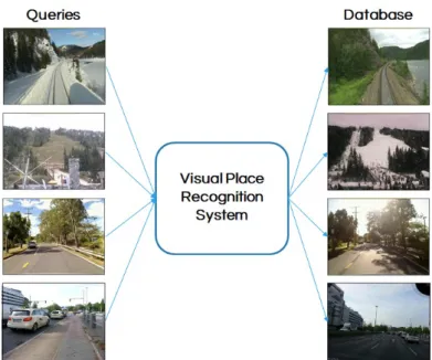
Fig. 1.3 A visual place recognition system takes query images as an input and returns the visually similar database images for localization.
In visual place recognition, captured images of the places within an environment are stored in a database. Therefore, runtime comparison of the query with the stored database is performed with closest database image which is considered as a currently visible place (location) as shown in Fig. 1.3. Recent advancements in computer vision improve the
6 Introduction performance of localization systems utilizing different robust feature detectors that interpret visual information efficiently.
1.4
Problem Statement and Challenges
Visual place recognition is a well-known paradigm where contemporary algorithms perform relatively well in environments with minimal dynamic instances but often challenging in complex outdoor and extreme environments. In particular, due to large-scale environmental variations experienced in the form of drastic appearance changes coupled with viewpoint variations, visual place recognition becomes difficult to achieve. This dissertation addresses the visual place recognition challenges by making sure that even under such perceptual and environmental changes, the object still correctly localize itself within the environment using the visual information. In Fig. 1.4, two cases of place recognition are presented. In (a), under day-night transition, the system still retrieves the correct match for a query image taken at the same place at night time whereas in (b), the retrieved image looks very similar to the query but geographically different, a problem known asperceptual aliasing. An efficient visual place recognition system should be able to correctly localize (match) a place (location) while minimizing the incorrect match.
Fig. 1.4 A generic visual place recognition system must be able to successfully recognize (a) the correct place irrespective of the visual changes and (b) reject the visually similar but geographically different places (Image taken from [2]).
To differentiate two places or locations in the form of captured images, the first step is to produce a compact image representation in the form of feature descriptors. Two geographically different places may look similar due to the surrounding atmosphere and
1.5 Thesis Contributions 7
environment, such as, a bar, an office etc. Therefore, to recognize the place correctly, it is important to identify and employ distinguishing and meaningful feature representations. In layman terms, we can say that the visual place recognition (localization) performance depends upon the feature descriptors being used for manipulating the visual information. Widely used feature descriptors include hand-crafted techniques (such as, Scale-Invariant Feature Transform [31] and Speeded-Up Robust Features [32]), deep learning techniques and 3D-based information (will discuss in more detail in Section 2.2). Similarly, techniques involved in feature matching vary and a better matching approach can improve the overall retrieval accuracy. Two widely employed recognition techniques include single image matching and sequence-based image matching. The most vital components involved for both feature description and feature matching are computation time and resource utilization. The mobile robots are usually battery operated and should be able to localize in real-time environment with minimum resource utilization.
1.5
Thesis Contributions
This thesis works around lightweight deep learning techniques coupled with single image matching for visual place recognition under changing appearance and viewpoint. The proposed approaches are tested and evaluated on several publicly available benchmark place recognition datasets, where the final outcome of this dissertation is to have a real-time lightweight visual place recognition system. The main contributions of this thesis are as follow:
1. The first contribution is associated with the exploration of regions-based Convolutional Neural Networks (CNNs) techniques that can be effective for place recognition under uncertain perceptual and environmental variations. Two places captured from the same location can appear differently due to the changing viewpoints and conditions. Therefore, identifying the common regions across places can improve the VPR per-formance. I have proposed a novel place-centric, region-finding approach employing convolutional layers of the CNN models.
2. The second contribution addresses the scalability and runtime matching performance. Once the robot experiences a new environment, it captures, stores and updates the reference map. It is important to have compact representation of the stored infor-mation so that runtime feature matching can be fast. The identified regional feature representations are encoded into Vector of Locally Aggregated Descriptors (VLAD). Precisely, regional features are quantized to the pre-trained dictionary clusters and their
8 Introduction accumulated residuals are concatenated to retrieve a VLAD representation, followed by their cosine matching such that the database image with highest score is treated as the final match.
3. Deep learning techniques are computationally expensive, and it becomes important to determine the runtime resource and memory utilization. Thus, it is critical to make sure that the computation and memory requirements are economical which makes the proposed place recognition frameworks suitable for resource-constraint mobile robots. Instead of deep neural networks, we have employed shallow CNN models to meet the real-time demand while improving the recognition performance at low memory and time cost. We have experimentally shown that our proposed region-based features extracted from less-layered CNNs can still deliver better results against state-of-the-art deep CNN-based place recognition contemporary techniques.
1.6
Thesis Structure
The rest of the thesis is divided into four chapters:
InChapter 2, existing approaches for visual place recognition are reviewed. Depending upon the feature describing methodologies, the visual place recognition techniques are classified into: techniques which employ global descriptors, local descriptors, and techniques that are a combination of both the global and local descriptors. Other approaches employ deep CNNs and 3D information for visual localization. Similarly, feature matching can either be single image or sequence of images based matching, as discussed further in this chapter. As presented in Section 2.2.5, region-based CNN techniques are capable of improving the VPR performance under changing environmental conditions. Taking inspiration from the regional techniques, a novel regions finding approach is proposed inChapter 3. To reduce the memory footprint and time consumption, shallow CNN (AlexNet) pre-trained on scene-centric Place365 dataset [33] is employed. CNN-based regional features are coupled with VLAD encoding for single image matching. The proposed framework is evaluated on several challenging benchmark datasets and achieves boostup in matching speed and accuracy over state-of-the-art contemporary VPR algorithms in terms of area computed on precision-recall curves.
Rich semantic CNN-based regional features have shown robustness against severe visual changes along with moderate viewpoint variations, as illustrated in section 2.2.5.Chapter 4 presents a multi-scale attention-based CNN approach for environment invariant visual place recognition. The presented technique is tested on publicly available datasets with environment experienced by real-world robots. The multi-layer context-aware framework
1.7 List of Publications 9
is employed on shallow HybridNet (pre-trained on place recognition-centric SPED [4]) and achieves better performance than deep neural network based VPR approaches at lower memory footprint and computational resource utilization.
InChapter 5, a summary of the achieved outcomes and discussion of their relevance to the current research and future work in visual place recognition is presented.
1.7
List of Publications
Following contributions were made during this course of study:
1. Khaliq, A., Ehsan, S., Chen, Z., Milford, M., and McDonald Maier, K. (2019)., "A Holistic Visual Place Recognition Approach using Lightweight CNNs for Significant ViewPoint and Appearance Changes". Accepted and published as a short paper in IEEE Transactions on Robotics (T-RO).
2. Zaffar, M., Khaliq, A., Ehsan, S., Milford, M., and McDonald-Maier, K. (2019b)., "Levelling the Playing Field: A Comprehensive Comparison of Visual Place Recog-nition Approaches under Changing Conditions". Accepted in IEEE International Conference on Robotics and Automation (ICRA 2019) workshop.
3. Zaffar, M., Khaliq, A., Ehsan, S., Milford, M., Alexis, K., and McDonald-Maier, K. (2019a)., "Are State-of-the-art Visual Place Recognition Techniques any Good for Aerial Robotics?". Accepted in aerial robotics workshop at IEEE International Conference on Robotics and Automation (ICRA 2019).
Chapter 2
Literature Review
This chapter presents an overview of the relevant research work in the area of visual place recognition. It starts with the core components, namely: describe a place, store a place repre-sentation and recognize a revisited place, followed up by their pertinent works respectively.
2.1
Overview
With the availability and accessibility of economical cameras which provide rich visual information, vision-driven localization and place recognition are getting more and more attention [34][35][36][37]. In the context of place recognition, visual information of a place/location is stored in the form of the captured image. A vehicle or robot localizes itself within an environment by identifying and recognizing the location previously encountered through an image retrieval mechanism [2]. However, the recognition techniques should be robust such that even when the estimated metric position of the robot is inaccurate, it can still localize the robot.
The contemporary research challenge in visual place recognition is to deal with the uncertainty of the changing environment [38][39] because the appearance of the same place changes abruptly at multiple times of the day and months, coupled with viewpoint changes induced by the different viewing positions of the robot [40]. Fig. 2.1 illustrates the basic mechanism of vision-aware place recognition with components described as follows.
1. Image processing module: The module takes the visual data as an input, coming from the visual sensors (such as, camera) and processes the rich semantic visual data, followed by the identification and extraction of useful information in the form of feature descriptors [2].
12 Literature Review
Fig. 2.1 Incoming visual data is processed by the image processing module and its description is stored in the place mapping framework. The belief generation module takes the decision by matching the current location with the stored places.
2. Place mapping framework: A map of the surrounding environment is stored in the form of the feature descriptors. It updates the map once encountered with the new places. Depending upon the purpose, a places map can be divided into following categories:
(a) Database-centric: It is a simplest way to remember a particular environment by storing the visual information in the form of captured frames. Therefore, recognition is entirely based on how similar the visual places are, often treated as image retrieval problem [41]. However, valuable information including relative pose is not stored which makes place recognition less precise but computationally efficient. This thesis is focused on database-centric place remembering approach. (b) Topological maps: This category of remembering places captures the relative information of the location in an environment [37][27]. It can be a collection of images captured in sequence.
3. Belief generation module: Within this module, the query/current visual information is compared with the stored information and the system retrieves the best matched database image (place recognition decision). Generally, if two places are captured at the same or different location then their descriptors similarity is determined by the matching score. Matching with single image and sequence of images are the two conventional place recognition approaches [42]. However, sequenced-based matching is more robust as it reduces the false-positive scenarios but this thesis focuses on single image matching for place recognition as it is computation efficient.
To perform the task of visual localization via appearance-aware place recognition, it is necessary to extract the useful visual information in the form of feature descriptors. Under uncertain environmental variations, the performance of the place recognition system depends upon the approaches employed for processing the visual information. Existing visual feature
2.2 Visual Place Recognition Methodologies 13
description approaches differ on the basis of visual data processing. Therefore, these can be: local features, global features, a combination of both the local and global features, 3-Dimensional features and deep learnt CNN features. Similarly, recognizing approaches either use single image of a place or collection of images captured in a sequence for matching purpose.
In this chapter, we will discuss the contemporary techniques proposed for place recogni-tion based visual localizarecogni-tion. The rest of the chapter is organized as follows: Secrecogni-tion 2.2 discusses the multiple place describing approaches. Section 2.2.6 presents the matching tech-niques used for place recognition. Section 2.3 highlights the contemporary state-of-the-art VPR techniques. Section 2.4 and 2.5 discuss the benchmark place recognition datasets and evaluation criteria. Section 2.6 summarizes this chapter.
2.2
Visual Place Recognition Methodologies
A place in an environment is a distinctive location and should be describe in such a way that it should be scalable and efficiently recognized whenever revisited. In the literature, many techniques for place recognition have been proposed which differ in the process of extracting visual information. Some approaches select regions that are in some way meaningful and notable; and others that process all the visual data with no region selection block. Similarly, there are techniques that use the 3-dimensional information and state-of-the-art neural network based techniques in which an image is passed into the input layer, and responses at some certain layer(s) are pooled and employed as feature descriptors.
2.2.1
Approaches based on Local features
Techniques employing local features first analyze the visual data (image) and then the detection of the meaningful keypoints at various spatial locations is carried out, named as local features [43][44]. The detection is based on the distinctive pixel patterns coupled with the description at that spatial location. Within each location, concatenation of the neighbour pixels is performed for retrieving final multi-dimensional floating-point feature vector or bit strings [45].
Local features are typically invariant to affine transformations including image scaling and camera rotation. Therefore, in places with similar environment and scenes, conventional local feature descriptors can be utilised. Research work in the context of place recognition is still a growing research domain, as evidenced by citation analysis and several workshops and IEEE conferences including IEEE International conferences on Robotics and Automation
14 Literature Review
Fig. 2.2 Example of local and global descriptors for place recognition (Image taken from [2]).
and Computer Vision and Pattern Recognition. It all started from the development of Scale-Invariant Feature Transform (SIFT) detector [31] and Speeded-Up Robust Features (SURF) [32], used for visual localization shown in Fig. 2.2. In Fig. 2.2 (a), an image is processed by local SURF feature detector, with circles denote the keypoints. For global descriptor as in Fig. 2.2 (b), the image is subdivided into grids and each block is separately processed. Place recognition with local descriptors is usually robust under viewpoint changes whereas global approaches are efficient under conditional changes.
Recent development of local binary feature detectors enables the research community to improve the description and recognition of places [46]. Such detectors are quite efficient and invariant to monotonic gray-scale changes. A typical Local Binary Pattern (LBP) feature detector is employed in [47], and coupled with support vector machine (SVM) based model for place recognition. Other local detectors include Binary Robust Independent Elementary Features (BRIEF) [48], oriented BRIEF (ORB) [49], Binary Robust Invariant Scalable Keypoints (BRISK) [50], Local Difference Binary (LDB) [51], KAZE [52] and Fast Retina Keypoints (FREAK) [53], which were usually employed in earlier place recognition systems.
Local feature descriptors possess high discriminative power which results into better recognition performance. However, they are computationally inefficient and suffer from higher dimensionality of the features. Bag-of-Words (BoW) [54], is an efficient feature quantizing technique where local features are assigned to particular centroid (words) of a trained vocabulary, as shown in Fig. 2.3. Thus, BoW results in a compact representation of the place with low dimensional vector or binary string. It ignores the geometric information of the place and performs recognition regardless of the topology of the deatures, technically termed as pose invariance. However, it is very sensitive to extreme conditional variance [55] and underperforms under lightening and seasonal changes. It is because the identified local feature descriptors are less distinctive in such kind of visual changes which leads to incorrect place matching.
2.2 Visual Place Recognition Methodologies 15
Fig. 2.3 K-means clustering of the feature descriptors with each cluster center treated as a visual word.
2.2.2
Approaches based on Global features
The previous section reviewed methods that put more focus on sub-regions/parts of the image. Such feature extraction techniques are quite efficient under partial occlusions and viewpoint variance, but they do not generally consider the whole scene or the structure of the place. In comparison, this section discusses the global feature detectors which process and describe the whole image for place recognition.
Global features are quite fast and robust under uncertain environmental variations. For place recognition, widely used global descriptors include color histograms [37] and His-togram of Oriented Gradient (HOG) [56]. Ulrich et al. in [37] used six one-dimensional color histogram from HLS and RGB color spaces coupled with nearest neighbor scheme in their topological map for retrieval. Their whole image-based place recognition system successfully matched 87% of the images. In [56], a vision-aware navigation system was proposed within which HOG employed as feature representations, followed-up by the descriptors comparison for determining the similarity.
Later, Winters et al. in [57] have utilized an omni-dimensional camera for creating the topological map. Principal Component Analysis (PCA) was employed for image compression and dimensionality reduction with appearance-aware localization determines the global topological position of the robot. A popular global descriptor GIST [58], introduced for scene recognition has been employed in [59] for place recognition. It used Gabor filters at different orientations and frequencies for features extraction, resulting into a compact vector representing the overall scene.
Concatenation of local features is also studied and represented as global image represen-tation. Using omni-directional cameras, Lamon et al. in [60] used edges, corners and color patches, combined them as features for rotation-invariant place recognition. A whole image based technique WI-SURF used SURF detector on the whole image with investigations
16 Literature Review claiming better matching performance for long-term localization. Similarly, combination of the BRIEF-GIST [61] detector for place recognition found to be resource efficient without the need of trained vocabulary.
Other approaches include grid-based image partitioning (illustrated in Fig. 2.2(b)), followed by the concatenation of each grid feature to retrieve the final descriptor. Lategahn et al. in [62] proposed an illumination robust feature over small image regions and normalized filter responses were used with results confirming better loop closure performance. Generally, global features are convenient to determine and scalable for large-scale place recognition. These approaches are invariant to conditional changes but less effective under viewpoint variations.
2.2.3
Approaches based on a Combination of Local and Global
fea-tures
Both local and global feature descriptors have shown increasing level of integration for early visual place recognition techniques. Taking precedence of their individual advantages, the research community has proposed several frameworks based on a combination of feature descriptors for place recognition [38].
Murillo et al. in [63] used omni-directional camera and proposed a three-step hierarchical architecture for localization. Color based global detector was applied, followed by the line features description to retrieve the visually similar image employing pyramidal matching of their line supported regions. Using omni-directional camera, Goedemé et al. in [64] extracted the vertical segments of each image coupled with the description of ten different descriptors. The local descriptors were clustered and then inserted into a kd-tree structure for efficient retrieval. For each query image, same descriptors were employed on the vertical image segments and later used for possible loop candidates retrieval. For accurate matching, column segments’ matching distance was applied between the candidates and query image. A real-time appearance-aware place recognition system was proposed in [65] which combined Features from Accelerated Segment Test (FAST) and Complete Center-symmetric Local Binary Patterns (CSLBP). BoW and SVM were integrated with results showing robust and high real-time place classification. A combination of local and global descriptor based techniques, Hull Census Transform (HCT) proposed in [66]. It first filters the SURF features which are composed of convex hull then computed their relative magnitude, resulting into a set of binary vectors efficient for scene detection. A similar approach in [67] combined local features, edges and colour histograms such that Harris detector was used for regions of interest and edges, followed up with SIFT description.
2.2 Visual Place Recognition Methodologies 17
2.2.4
Approaches based on 3D information
In addition to rich semantic 2D visual data, metric information transforms it into three-dimensional information. Stereo cameras are employed as a source of metric information whereas monocular cameras with structure-from-motion techniques such as MonoSLAM [68], LSD-SLAM [69] and ORB-SLAM [70] can also provide the required metric information.
In the literature, several works have been proposed employing three-dimensional infor-mation for visual place recognition. Cummins et al. in [27] extended the Fast Appearance Based Mapping (FAP-MAP) by adding spatial distribution of 3d-based visual words. A similar strategy was proposed in [71] that coupled the 3D metric information with stereo image sequences for place localization. In [72], Morioka et al. have proposed a SLAM based navigation system which extracted 3D Position Invariant Robust Feature (PIRF) from the sequential images with results demonstrating effective outdoor localization. A 3D point cloud and depth image based descriptor which is a variant of Surface Entropy for Distinctive 3D Features (SURE) is showed in [73] discussing the applicability of SURE features coupled with BoW approach for indoor place localization.
Maddern et al. in [74] proposed Continuous Appearance-based Trajectory SLAM (CAT-SLAM), an appearance-based place recognition system that filtered the local metric pose for improving the frequency and reliability of loop closure. Its extension integrated appearance with local odometry information, named as CAT-Graph later introduced in [75]. With a large-scale loop closure detection, it demonstrated the recall boostup in performance from FAB-MAP by a factor of 3 at 100% precision. Cadena et al. in [76] introduced a stereo vision-based recognition architecture which employed BoW feature encoding for retrieving loop closure candidates, coupled with Conditional Random Fields-Matching (CRF-Matching) for verification. However, the matching approach was found to be more robust than using epipolar geometry only because it used 3D information from stereo images.
Cadena et al. in [71] proposed a SLAM-based place recognition system by considering both the visual and geometric information coming from the camera. Loop closure hypothesis was evaluated by coupling the appearance based approach with BoW model. Results in both indoor and outdoor environments claimed zero false-positives (full precision) for a few false-negatives (high recall). Sensors including RGB-D cameras [77] were used and coupled the depth information with visual data and further improved place recognition system/performance [78].
18 Literature Review
2.2.5
Approaches based on Deep CNN features
Visual Place recognition techniques based on handcrafted features are generally sensitive towards simultaneous conditional and viewpoint variations. Therefore, their performance in uncertain extreme environments relies on the type of feature detector employed. FAB-MAP, a combination of SURF-BoW was found to be robust in dealing with viewpoint changes whereas SEQSLAM performed better in changing conditions due to its whole image-based approach. However, such techniques have shown inferior performances under simultaneous changes observed in illumination, conditional or different camera position. Thanks to deep convolutional neural networks which have shown stronger generalization power to describe the places [79] with robustness to conditional and viewpoint variations.
In 1989, LeCun et al. in [80] for the first time introduced the idea of a Convolutional Neu-ral Network (CNN). The proposed architecture consisted of multi-layered network, trained on human annotated datasets and automatically learned features at multiple scales through classification-based training. In comparison with conventional handcraft-based feature de-tectors, CNNs have shown state-of-the-art performance for image/object classification and recognition [81][82]. However, collection of the labelled large-scale datasets for training the neural network and resources for computation are the early limitations faced by the research community. The recent advent of GPUs encouraged and allowed the research community to perform resource intense calculation, such as, back-propagation [83].
Encouraged from the initial boom of deep learning, Chen et al. in [84] presented a visual place recognition system employing powerful CNN features coupled with spatial and sequential filter. Evaluating the proposed framework with a 70km Eynsham dataset claimed 85.7% recall at 100% precision. Later, [40][85] coupled external landmark detectors with pretrained object-centric CNNs employing locality-sensitive hashing and optimization approach for region-based real-time place recognition. The regional CNN features were found to be robust under strong viewpoint and conditional changes. Further investigation in [86][4] demonstrated that middle convolution layers emphasize upon edges and colours, thus, efficient under conditional variations.
Arandjelovic et al. in [3] added a Vector of Locally Aggregated Descriptor (VLAD) layer inside the CNN architecture (shown in Fig. 2.4). Using back-propagation, it trained the model on a newly collected large scale urban dataset containing dynamic objects, coupled with appearance and viewpoint changes. The framework was evaluated on Tokyo, Oxford and Paris datasets with results claiming superior performance of deep CNN features. Gomez-Ojeda et al. in [87] trained a CNN model for recognizing revisited places under strong conditional variations. Images were mapped onto the lower dimension with euclidean distance calculation for place similarity. To deal with the appearance variance, the authors
2.2 Visual Place Recognition Methodologies 19
used triplet of images for training the neural network such that one image presents the same place with different conditions and other with different place exhibiting similar environment.
Fig. 2.4 Convolutional Neural Network (CNN) with the NetVLAD layer (image taken from [3]).
Pooling responses from convolutional layers have been an area of research interest for computer vision and robotic communities. With the advent of several feature pooling techniques including Sum-Pooling [88], Max-Pooling [10], Spatial Max-Pooling [89] and Cross-Pooling [90] employed in deep CNNs have demonstrated performance boost in tasks requiring image classification/recognition and object detection/retrieval [10][90]. Applying a specific sized window over convolutional layer’s feature maps and picking responses either based on the max value, termed as Max-Pool [10], adding all the values - Sum/Average-Pool [88] or mapping the window’s responses into the previous layer, known as Cross-Pool [90]. All such response pooling techniques have shown performance boost in vision-based image retrieval tasks where the image is majorly covered with a single object. Responses within feature maps are non-uniformly distributed and finding single or fewer regions of interest becomes relatively easier. However, such image retrieval tasks are different in nature from the VPR systems where recognizing a place which undergoes diverse changes due to illumination, winter to summer transitions or viewpoint variance added by different capturing angles is quite challenging. It is because the same place appears differently thus making it harder to identify the common regions. Even when the above mentioned pooling techniques are integrated on external tasks based pre-trained CNNs for the VPR problem, the convolutional layers feature maps focus on the trained objects such as vehicles, pedestrians and other non-salient objects which are not suitable for place recognition [5]. Therefore, a generic Visual Place Recognition system capable of efficiently dealing with simultaneous viewpoint and condition variations remains an open challenge.
Using an Archive of Many Outdoor Scenes (AMOS), a 2 Million diverse Specific Places Dataset (SPED) was collected in [4]. SPED contains thousands of images captured at each place throughout the year. Each place is treated as a label and with millions of places allowing classification-based fine-tuning (HybridNet) of the object-centric CaffeNet [91] and training from scratch (AMOSNet). Spatial Pyramid Pooling (SPP) for feature extraction
20 Literature Review
Fig. 2.5 Images from the spring season are matched against the winter season. Feature heat maps in the first and second columns are taken from HybridNet [4]. The third column exhibits the heat maps of CaffeNet.
was employed for picking responses from the convolutional layers. SPP picks activations from convolutional layers at multiple scales e.g. [1 2 3 4] by dividing each feature map into scale based cells and apply max-pooling on each cell to pool the responses. By evaluation on publicly available benchmark datasets, fine-tuned HybridNet claimed performance boost over AMOSNet, CaffeNet and AlexNet. Furthermore, deep investigation on HybridNet showed that middle convolutional layers focused on corners, edges and colours where higher layers captured semantically meaningful regions under strong conditional changes, such as, building structures which means the network has learned appearance invariant features as shown in Fig. 2.5. It is evident that HybridNet fires at semantically meaningful regions whereas CaffeNet’s responses are less meaningful due to object-centric CNN training.
Fig. 2.6 A place recognition system utilising deep VGG-16 pre-trained on ImageNet under strong viewpoint and moderate conditional changes (Image taken from [5]).
Motivated from [92][90] which employed a cross-convolutional technique for image recognition and classification, Chen et al. in [5] proposed a region-based VPR system, illustrated in Fig. 2.6. Particularly, salient CNN-based regional representations were identi-fied (shown with different colours) for recognizing places under simultaneous viewpoints
2.2 Visual Place Recognition Methodologies 21
and conditional changes. Employing deep object-centric VGG-16 and a cross-convolution based regional approach was used such that group of connected activations from the late convolutional layer are filtered on the basis of their energies followed up by their mapping onto the previous convolutional layer for CNN-based regional extraction. Based on the regional features, places are recognized using BoW encoding approach.
Fig. 2.7 A deep neural network based place recognition framework focusing on context-flexible attentions. Two exemplars with their heat maps are shown here (image taken from [6]).
Recently, the authors in [93][94][6] have demonstrated that fused features from multiple convolutional layers can improve place recognition under visual changes. Jin Kim et al. in [94] proposed a fixed context-aware attention model that captures the manually defined rectangular shaped most contributing distinctive patterns efficient for visual localization. Work in [4][93] demonstrated that different convolutional layers capture different semantic information. Chen et al. in [6] fine-tuned the deep object-centric VGG-16 on SPED dataset and employed fused multi-scale features for place recognition. A context flexible block is integrated within the late convolutional layers which automatically learns context flexible at-tentions upon fine-tuning on SPED dataset. Evaluations based on fused multi-layer atat-tentions were found to be efficient under severe conditional changes coupled with moderate viewpoint changes. However, the efficiency of the proposed approach may be compromised if there is a simultaneous severe viewpoint and conditional variation. Moreover, performance and efficient resource usage have become two important aspects to be looked into for real-world VPR applications.
Image retrieval tasks which either rely on handcrafted features, such as, local SIFT and SURF features [32][31] or combining these with convolutional and fully connected layers of
22 Literature Review deep/shallow CNNs [95][96][84], Bag-of-Words (BoW) or Support Vector Machine (SVM) [97] are employed for classification, detection and recognition [10][90] purposes. As an alternative for BoW feature encoding scheme, several other approaches including Fisher vector [98] and Vector of Locally aggregated descriptor (VLAD) have shown promising results with smaller visual words vocabularies [99]. To perform instance level image retrieval where objects from the same category are to be separated, [96] suggested to combine the rich spatial middle convolutional layers’ features with VLAD encoding. Jin Kim et al. in [100] employed MSER [101] for regions identification, followed by the detection of SIFT features within the identified regions and described each region/bundle as a fixed size VLAD, named as PBVLAD. 2D-based localization methods generally offer efficient database management at lower accuracy cost whereas 3D-based techniques are computationally complex but more reliable in localization. Sattler et al. in [102] refuted this notation by combining 2D-based approaches with SfM-based post-processing and have shown better performance than structure-based methods. Merrill et al. [103] trained a convolutional auto-encoder in an unsupervised manner. The objective of auto-encoder based VPR was to re-create the HOG descriptor of original image using a distorted version of the original image as input.
Recently, Teichmann et al. in [104] trained the landmark detectors [105][10] with a newly introduced 1.2M Google Landmark Dataset (GLD). It contains 15k landmark categories including buildings, monuments and bridges annotated by human. They have proposed a technique which retrieves the normalized regional residuals, termed as R-VLAD. Thus, it down-weights all the regional residuals and stores a single aggregated regional descriptor per image. Custom landmark detectors including ASMK [106], RMACB [105], RMAC [10] and selective search [107] are incorporated for the regional search and coupled with the proposed R-VLAD on deep CNNs.
2.2.6
Image Matching
Matching approaches for visual place recognition can be classified into two categories; 1) using one single frame and 2) using two or more captured frames in the sequence for recognition purpose.
Single Image Matching
In this category, visual place recognition is performed with a single image of a query place. An image database is pre-collected and stored for runtime matching with the query location. By employing a VPR, the most similar database image is claimed as the place currently encountered by the robot or vehicle. However, it is important for two places to be visually
2.2 Visual Place Recognition Methodologies 23
Fig. 2.8 VPR using single image matching.
similar to the extent that they can be claimed as representing the same physical location. Therefore, in single image matching approach (shown in Fig. 2.8), the query place is captured once in a single frame, compared with all the stored places and a visually similar image is retrieved as the localized place.
Various VPR algorithms have employed a single image of the current scene and matched with the stored image collection [2]. FABMAP was the first to employ single frame matching approach; detected SURF keypoints on the visually captured appearance of the place and combined it with BoW model for single query matching with the reference frames. During training, the employment of the BoW encoding with SURF descriptors allowed to determine the distinctiveness of each feature/word. Chow Liu tree was employed for measuring the probabilities of the visual words carried out by determining the maximum-weight spanning tree of a directed graph of co-occurrence between the visual words of training dataset. Multiple places exhibiting similar environment were efficiently tackled by FAB-MAP using common visual words approach such that the less common words highlight difference in places and vice-versa.
24 Literature Review Knopp et al. in [108] performed single image-based place recognition using BoW encoding mechanism. They demonstrated that single image matching approach is easier and simpler to deploy. However, under large scale extreme environments, place recognition with single image matching is sensitive towards lightning changes and dynamic objects including vehicles and pedestrians. Similarly, neural network based VPR approaches also employed single matching technique for retrieval purposes [4][5][6]. These techniques pass down a single frame of a location and extract middle and late convolutional layers as features representation. This is then followed-up by post feature matching with reference image descriptors such that the maximum matching score is claimed as the currently visible location.
Sequence-based Image Matching
Earlier VPR techniques used an assumption that the appearance of places would not expe-rience any changes in indoor environments. However, robot localization in extreme and uncertain outdoor environments refute to this assumption and under such visual changes, appearance aware place recognition techniques sometimes underperform with single image approach [2]. Therefore, in the presence of lightning and weather changes, instead of em-ploying single place similarity, a sequence of images is preferred to be matched for VPR. A sequence can be a combination of two or more frames, therefore, by utilising sequences even from different times of the month or year can still lead to recognize successful VPR, as illustrated in Fig. 2.9. Each test sequence needs to match with the specific reference sequence captured in a different time interval.
Sequence-based Simultaneous Localization and Mapping (SeqSLAM) was the first sequence based place recognizing technique introduced in [42]. Particularly, the matrix of image similarities between the current image sequence and reference image sequence was computed, followed up by the sum of absolute difference of their enhanced contrast for image similarity. The maximum sum of normalized similarity was treated as the recognizing score measured through a matrix over predefined constant velocity sequence paths.
2.3
State-of-the-Art Visual Place Recognition techniques
Wide range of VPR techniques are proposed by the research community with some focused-on cfocused-onditifocused-onal- or appearance-variance while others emphasis upfocused-on the viewpoint changes. Under common-ground, Zaffar et al. in [109] assess and tested multiple VPR approaches on three challenging place-recognition datasets exhibiting seasonal, conditional and viewpoint vairations. The work provides a comprehensive evaluation of 10 state-of-the-art contemporary
2.3 State-of-the-Art Visual Place Recognition techniques 25
Fig. 2.9 VPR using sequence-based image matching.
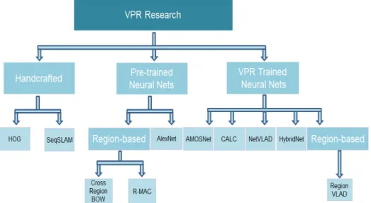
VPR techniques in a chronological order, shown in Fig. 2.10. It includes HOG, SeqSLAM, AlexNet, NetVLAD, AMOSNet, HybridNet, Cross-Region-BoW, RMAC, Region-VLAD and CALC. Tthe expected increase in VPR performances have not been observed in a chronological order but investigations based on matching performance, retrieval time and memory requirement claim that deep neural network based VPR techniques are better under severe seasonal, illumination and viewpoint variations but at the cost of memory whereas handcraft-based VPR frameworks have shown inferior results at low resource utilization.
Another work by Zaffar et al. in [7] evaluates the applicability of ground-based VPR techniques for aerial robotics. They employed two recently open-sourced aerial robotics datasets [110] exhibiting 6-DOF viewpoint variation and evaluated 8 state-of-the-art ground-based VPR approaches. It gives a bird-eye view of applicability of the VPR systems that work quite well under lateral viewpoint variation shown in Fig. 2.11. Therefore, performance analysis of these techniques under 6-DOF is carried out while considering run-time processing power and memory consumption in real-time aerial robotic application. The results showed that NetVLAD again outperformed other regions-based techniques under
26 Literature Review
Fig. 2.10 Hand-crafted and neural network-based contemporary VPR techniques.
6-DOF viewpoint variation. However, most neural network based VPR techniques are not scalable for resource-constrained platforms like aerial robots. Cross-Region-BoW leads to highest power consumption due to its intense matching scheme, as illustrated in Table 2.1.
Fig. 2.11 Examples of 6-DOF (degree of freedom) and lateral viewpoint variations. (image taken from [7])
2.4
Benchmark Visual Place Recognition Datasets
In the context of place recognition, datasets proposed by the research community vary in terms of seasonal, viewpoint and illumination variations. Some datasets exhibit stronger viewpoint changes coupled with moderate conditional variations, others are captured under
2.4 Benchmark Visual Place Recognition Datasets 27
Table 2.1 Computational power requirements (taken from [7])
Techniques
CPU Utilization Time (sec) Power Consumption (Ah)
Encoding Matching Encoding Matching
Intel(R) Xeon(R) Gold 6134 CPU @ 3.20GHz with 32 cores, 64GB RAM
AlexNet 0.734 0.0312 0.666 3.222 0.3128 NetVLAD 0.656 0.036 0.77 0.0374 0.2688 AMOSNet 0.437 0.03 0.359 0.614 0.0931 HybridNet 0.437 0.03 0.357 0.584 0.0921 Cross-Region -BoW 0.32 0.1 0.834 1199.04 63.836 RMAC 0.5 0.371 0.478 0.254 0.1768 Region-VLAD 0.25 0.031 0.463 0.899 0.0764 CALC 0.781 0.0312 0.027 0.974 0.0272
stronger conditional and adequate viewpoint variations. For all the datasets, two traverses along the same route are taken at multiple times of the day/year. More specifically, the datasets employed in this thesis includeBerlin Halenseestrasse[40],Berlin A100[40],Berlin Kudamm[40],Gardens Point[84],Synthesized Nordland[23],Query247[8],St. Lucia[4] andSPEDTest[6]. All the Berlin datasets are captured in urban environment and have been introduced and employed for evaluating VPR approaches [40][4]. Crowd-sourced geotagged photo-mapping platformMapillary[111] is used for gathering the Berlin datasets. Traverses of the same route are uploaded by different users exhibiting viewpoint and conditional variations among the same places. Berlin Halenseestrasse and Berlin Kudamm datasets exhibit strong viewpoint variations. Other datasets including Berlin A100, Gardens Point, Synthesized Nordland, Query247 and SPEDTest exhibit strong illumination and seasonal changes. Gardens Point dataset was captured at QUT, Brisbane campus with one traverse taken during daytime on left side walk and the other traverse was recorded in right side walk at night time [4]. The Synthesized Nordland dataset was recorded on a train with one traverse taken in winter and reference traverse w
![Fig. 1.4 A generic visual place recognition system must be able to successfully recognize (a) the correct place irrespective of the visual changes and (b) reject the visually similar but geographically different places (Image taken from [2]).](https://thumb-us.123doks.com/thumbv2/123dok_us/1072153.2642678/24.892.202.667.658.922/generic-recognition-successfully-recognize-irrespective-visually-geographically-different.webp)
![Fig. 2.2 Example of local and global descriptors for place recognition (Image taken from [2]).](https://thumb-us.123doks.com/thumbv2/123dok_us/1072153.2642678/32.892.159.717.150.329/example-local-global-descriptors-place-recognition-image-taken.webp)

![Fig. 2.5 Images from the spring season are matched against the winter season. Feature heat maps in the first and second columns are taken from HybridNet [4]](https://thumb-us.123doks.com/thumbv2/123dok_us/1072153.2642678/38.892.120.756.160.378/images-spring-season-matched-winter-feature-columns-hybridnet.webp)