Laxman L. Kumarwad et al, International Journal of Computer Science and Mobile Applications, Vol.6 Issue. 4, April- 2018, pg. 38-45 ISSN: 2321-8363 Impact Factor: 5.515
Present Status and Issues of Land Record
System in Satara District, Maharashtra, India
Laxman L. Kumarwad
1, Rajendra D. Kumbhar
21
Government College of Engineering, Karad, [email protected]
2
KBP Institute of Management Studies and Research, Satara, [email protected]
Abstract: Land is a unique asset because it is immovable, its value depends on its location and with growing population, its demand keeps increasing, while its supply is limited. So the importance of land records shown since the ancient India. Maintenance of land records and easily accessibility of land information is one of the most important issues facing citizens and government today. Maharashtra is one of the pioneer state in providing the electronic services to the citizens in India. National Land Record Modernization Programme is one of them. Maharashtra is the leading state in implementation of National Land Record Modernization Programme. Under this project, various components are implemented in various modes as pilot basis or state wide. Many National Land Record Modernization Programme projects have been successfully implemented in pilot locations and now they are on the borderline of the state wide rollout. Comprehensive land records modernization and management system is proposed under programme called “eMahabhoomi” by the Maharashtra State. District Collectorate office is responsible for the execution and implementation of the National Land Record Modernization Programme project through its subsidiary offices like Tahasil, Circle and Talathi offices in the district. In this article, researcher studied and presented the status, ground reality and issues in Land Record System of the Satara district.
Keywords: Land Record System, NLRMP, Mahabhulekh.
1. Introduction
According to Maharashtra Land Revenue (MLR) Code 1966, "land records" means records maintained under the provisions of, or for the purposes of, this Code includes a copy of maps and plans or a final town planning scheme, improvement scheme or a scheme of consolidation of holdings which has come into force in any area under any law in force in the state and forwarded to any revenue or survey officer under such law or otherwise [1]. Land record department is controlled by the Director of Land Record and Settlement Commissioner at the state level. This work is done by the District Inspector of Land Record and Taluka Inspector of Land Record at the District and Taluka level respectively.
2. Land Records in Maharashtra
National Land Record Modernization Programme (NLRMP) was formed by merging two existing government of India sponsored Computerization of Land Record (CLR) and Strengthening of Revenue Administration and Updating of Land Records (SRA & ULR) with adding new components like registration and titling system [4]. The aim of this modernization is to minimize the scope of land/property disputes by enhancing the transparency in the land record management system and to facilitate guaranteed conclusive titles to immovable properties in the country. The main components of this programme are computerization of all land records, including mutations, digitization of textual and spatial data, survey/resurvey and updating of all survey and settlement records, including creation of original cadastral records wherever necessary, computerization of registration and its integration with the land records maintenance system, development of core Geospatial Information System (GIS) and capacity building.
Laxman L. Kumarwad et al, International Journal of Computer Science and Mobile Applications, Vol.6 Issue. 4, April- 2018, pg. 38-45 ISSN: 2321-8363 Impact Factor: 5.515
NLRMP based on four basic principles as follows 1) The “Mirror” principle: The mirror principle refers to the fact that cadastral records mirror the ground reality. 2) The “Curtain” principle: The “curtain” principle indicates that the record of title is true a depiction of the ownership status, mutation is automatic following registration and the reference to past records is not necessary. 3) A Single Integrated Window to handle land records: A single window for updating and maintaining of textual records, maps, survey and settlement operations and registration of immovable property. 4) Title Insurance: Title insurance, which guarantees the title for its correctness and the title holder against loss arising on account of any defect therein [3].
In financial year 2008-09, NLRMP project started under the original scheme of CLR and SRA & ULR which was started in 1988-89. All components of NLRMP have been started in the Maharashtra state. Each component‟s timeline is different and will be giving services to the citizens till a new guideline regarding the specific component is issued.
Maharashtra government has begun digitization of land records under the NLRMP which goes for introducing the arrangement of giving on the web access of land information and stopping of escape clauses. Aside from acquiring straightforwardness, digitization would give government correct information on the responsibility for, which will come helpful while giving a push to the procedure of industrialization. Digitization has been begun in all Talukas of the locale, out of which land information of 17 talukas has been uploaded on the web portal while for the rest trial runs are in progress. Once the land records are digitized, individuals will have the capacity to see points of interest of a specific land on the web portal, if citizens have the survey number. The citizens will likewise have the capacity to see their 7/12 extract which is a concentrate duplicate of the land enlist kept up by the income office on the web. Residents would not need to visit Talathi office once digitization processes are proficient. Individuals will have the capacity to see the status of a specific land record on the web portal. This implies that the citizens can buy the land, give deeds and so forth at the click of button. Also the mutation process will become automatic. Citizens will not have to visit Talathi Office any longer. The land record administration is conducting the trials in 341 Talukas wherein online information is being compared with the manual information, with specialized angles being investigated and wherever required revisions are being completed. Citizens will now know on whose name a specific land is enrolled and which land has been set apart as government land. The land record administration will have the correct points of interest of land accessible with it once the digitization procedure is finished. Getting points of interest of the accessible land will help us to give a push to industrialization and our shrewd urban areas extend.
Laxman L. Kumarwad et al, International Journal of Computer Science and Mobile Applications, Vol.6 Issue. 4, April- 2018, pg. 38-45 ISSN: 2321-8363 Impact Factor: 5.515
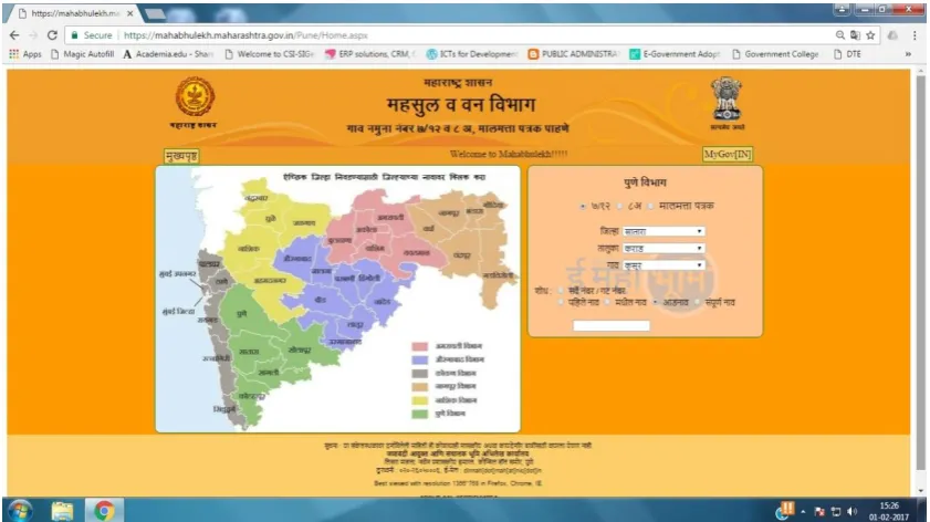
“Mahabhulekh” (http://mahabhulekh.maharashtra.gov.in/) is an online land record website of Maharashtra state. The website is started and maintained by Government of Maharashtra‟s Land Records and Settlement Commission. The website keeps the land records of Maharashtra state provide better services to the citizen. Home page of websites shows the division wise listing (as shown in figure 1).
The 7/12 extract in Marathi is called „Saat Baara Utara‟. The 7/12 extract is an extract from the land register of any district. This is maintained by the Revenue Department of the Government of Maharashtra.
2.1 Organization of Land Record Department
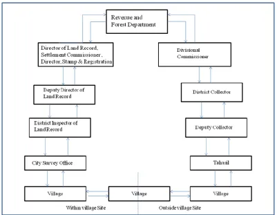
Land revenue system is organized on the basis of demarcation of land as belonging to territorial units of villages grouped into talukas, districts, divisions and the state. All aspects of land revenue system like the collection of the land revenue, disposal of government lands, compulsory acquisition of land for development and public purposes, land reforms, relief operations and related matters are dealt in revenue and forest department of government at state level. There is one principal secretary among three secretaries each in charge of land and its revenue matters, forest and relief operations. On the territorial basis specified by government in the official Gazette, down below, land record department is organised around graded administrative units comprised in revenue division namely Aurangabad, Amravati, Mumbai, Pune, Nasik and Nagpur. Each division has 4 to 6 districts; each district comprises 3 to 4 sub divisions divided into 3 to 4 talukas. Each talukas has five to six circles having 1 to 8 villages. There are 35 districts, 359 talukas and 44549 villages. Organization of the land record department is as shown in following figure.
Figure 2: Organization of the Land Record Department
3. Present Status in Satara district
Laxman L. Kumarwad et al, International Journal of Computer Science and Mobile Applications, Vol.6 Issue. 4, April- 2018, pg. 38-45 ISSN: 2321-8363 Impact Factor: 5.515
are the key persons at the village level land record activities. In the district, all Tahasils and Circle level offices are connected by Virtual Private Network on BSNL Broadband (VPNoBB) [5]. Following table shows the activities implemented in the system.
Table 1: Activities implemented in Mahabhulekh System
Sr.
No Purpose URL/Link Description
1 eFerfar https://10.187.203.134/eferfar2 (2.0 Beta)
Access using FortiClinet SSL VPN/ VPNoBB
/MSWAN Network 2 Pending ferfar
Updation https://10.187.203.134/odu2 (2.0 Beta)
3 Data Correction https://10.187.203.134/odc
4 Crop Updation https://10.187.203.134/ocu/
5 User creations https://10.187.203.132/usercreation/
For DDE/DBA only Access using VPN or
MSWAN Network
6 Help Desk Problem
Reporting URL https://103.23.150.216/hdrs/ For DBAs only
7 Online 7/12 Viewing http://mahabhulekh.maharashtra.gov.in Available for citizens
8 NLRMP User
Manuals https://10.187.203.135/ Login as Guest
9 Bulk printing of 7/12 https://10.187.203.108//OPG PDF Generation User Manual
10 eFerfar MIS Report
new http://10.187.203.101/eferfarMis/ new For DDE / DBA only
3.1 Status of Satara District Land Record System
Following tables shows the statistics of Land Record System in Satara district.
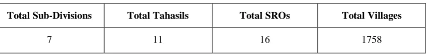
Table 2: Master Details
Total Sub-Divisions Total Tahasils Total SROs Total Villages
7 11 16 1758
Laxman L. Kumarwad et al, International Journal of Computer Science and Mobile Applications, Vol.6 Issue. 4, April- 2018, pg. 38-45 ISSN: 2321-8363 Impact Factor: 5.515
Table 3: Status of Computerization of Land Records (CLR)
No. of Villages : 1758 CLR Completed CLR Ongoing CLR Not Started Mutation Computerized Issuance of digitally signed RoR RoR Linkage With Aadhaar Completed RoR Linkage With Aadhaar Ongoing 1455 (82.76%) 303 (17.24%) 0 (0%) 1447 (82.31%) 0 (0%) 0 (0%) 0 (0%)
From the above table it is interpreted that computerization of land records process is 100% started in the district but 82.76% CLR process completed whereas 17.24% CLR ongoing. Furthermore, 82.31% mutation computerization is completed. Neither an issuance of digital signed RoR nor Aadhar linking RoR is started in the district.
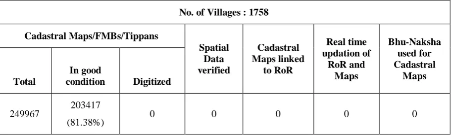
Table 4: Status of Map Digitization
No. of Villages : 1758 Cadastral Maps/FMBs/Tippans Spatial Data verified Cadastral Maps linked to RoR Real time updation of RoR and Maps Bhu-Naksha used for Cadastral Maps Total In good
condition Digitized
249967 203417
(81.38%) 0 0 0 0 0
Above table represents the status of the map digitization of the land record. 81.38% cadastral maps/FMB/Tippans are in the good condition whereas digitization is not done. Further, the spatial data, cadastral maps linked with RoR, real time updation of RoR and maps and bhunaksha used for cadastral maps, these works are not started yet in the district.
Table 5: Status of Modern Record Room (MRR)
No. of Tahasils : 11
Sanctioned Completed Ongoing Not Started Completed Civil/Electrical/ Sanitary etc. Procurement Done
11 0 11
(100%) 0
11
(100%)
11
(100%)
Laxman L. Kumarwad et al, International Journal of Computer Science and Mobile Applications, Vol.6 Issue. 4, April- 2018, pg. 38-45 ISSN: 2321-8363 Impact Factor: 5.515
Table 6: Status of Citizen Centric Services
No. of Tahasils : 11 Services provided
(No. of Tahasil) (%)
Citizen Centric Service provided through (In No. of Tahasils) (%)
Nature of RoR copy obtainable from Tahasil Office RoR Only RoR with Map Modern Record Room Tahasil Compute r Center
Online Manual
Comp uteriz ed
Both Non e
11
(100%) 0
1 (9.09%) 11 (100%) 11 (100%) 7
(63.64%) 0
4
(36.36%) 0
Above table represents the status of citizen centric services of the land record system. In the district, RoR service is providing in the all Tahasils without RoR map. Citizen Centric Service is provided through the MRRs is 9.09% whereas 100% service provided through the Tahasil computer center and through the online. There are 63.64% citizens of 7 Tahasils can obtain RoR manually. There is no computerized RoR obtain in the district.
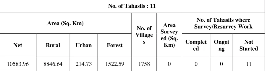
Table 7: Status of Cadastral Survey
No. of Tahasils : 11 Area (Sq. Km)
No. of Village s Area Survey ed (Sq. Km)
No. of Tahasils where Survey/Resurvey Work Net Rural Urban Forest Complet
ed
Ongoi ng
Not Started
10583.96 8846.64 214.73 1522.59 1758 0 0 0 11
Above table depicts the status of cadastral survey of the Satara district. There is no such work is started in the district.
Table 8: Status of Survey Revenue Maps No. of Tahasils : 11
No. of Villages Total Revenue Map generated Ground Truthing Final Promulgation
1758 0 0 0
Laxman L. Kumarwad et al, International Journal of Computer Science and Mobile Applications, Vol.6 Issue. 4, April- 2018, pg. 38-45 ISSN: 2321-8363 Impact Factor: 5.515
Table 9: Land Record System Transactions
Sr. No. Service Department Service Type Total Transactions
1 7-12 Extract LRMS G2C 5826
2 8A Extract LRMS G2C 998
Total 6824
Above table interpret that the land record system transactions during the FY 2016-17 through the CSC/SETU in the district. There are only two service offered through the CSC/SETU that are 7/12 extract and 8A extract. Total 6824 transaction are performed through the CSC/SETU out of which 5826 were 7/12 extract transaction and 998 were 8A extract transactions.
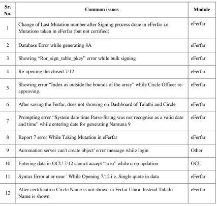
3.2 Common Issues in NLRMP
Following table shows the common issues found while using the NLRMP project.
Table 10: Common issues in NLRMP
Sr.
No. Common issues Module
1 Change of Last Mutation number after Signing process done in eFerfar i.e. Mutations taken in eFerfar (but not certified)
eFerfar
2 Database Error while generating 8A eFerfar
3 Showing “Ror_sign_table_pkey” error while bulk signing eFerfar
4 Re-opening the closed 7/12 eFerfar
5 Showing error “Index as outside the bounds of the array” while Circle Officer re-approving.
eFerfar
6 After saving the Ferfar, does not showing on Dashboard of Talathi and Circle eFerfar
7 Prompting error “System date time Parse-String was not recognise as a valid date and time” while entering date for generating Namuna 9 eFerfar
8 Report 7 error While Taking Mutation in eFerfar eFerfar
9 Automation server can't create object' error message while login Other
10 Entering data in OCU 7/12 cannot accept “area” while crop updation OCU
11 Syntax Error at or near ' While Opening 7/12 i.e. Single quote in data eFerfar
12 After certification Circle Name is not shown in Ferfar Utara. Instead Talathi Name is shown
Laxman L. Kumarwad et al, International Journal of Computer Science and Mobile Applications, Vol.6 Issue. 4, April- 2018, pg. 38-45 ISSN: 2321-8363 Impact Factor: 5.515
13 1c Correction (Blocking message) appearing while Taking Mutation in eFerfar as taken survey is of 1c)
eFerfar
14 Pending Ferfar number is shown On 7/12 but not Recorded any ferfar Edit
15 Showing message “Somebody working on this module” while taking new Ferfar eFerfar
16 Showing error while editing the record "UpdateRecord: ERROR: 23505: duplicate key value violates unique constrain "holder_details_pkey"
Edit
17 Message comes as Keyset is not defined while selecting the signature/login in Module
Edit
18 Data not signed error showing while saving the ODU ODU
4. Conclusion
It is found that in all 1758 villages of Satara district CLR process is started in which 1455 villages completed CLR, 303 villages CLR work in progress. Total 6824 G2C transactions are recorded in which 5826 transactions are carried for 7/12 extract and 998 transactions for 8A extract during FY 2016-17. Talathi and Circle Officers are facing a lot off issues and errors in software while using mutation process. It is concluded that the Land Record System project is in the implementation phase in the district. Digitization of the land record is not completed yet in the district so the citizens cannot view live land information. Now the citizens not getting the live access of the land records like 7/12 and 8A extract from this project. The government should take this project on priority so the citizens can get benefits. This will benefits to the all the government department as well for extraction of live information of the citizens.
References
[1] Definition, “Land Record”, Chapter 1, Preliminary, Maharashtra Land Record Code 1966
[2] Department of Land Records, Ministry of Rural Development, Government of India, 2018, National Land Records Modernization Programme(NLRMP)-2008 [Online], http://dolr.nic.in/NLRMP-2008.pdf
[3] Department of Land Records, Ministry of Rural Development, Government of India, 2018, Objectives of NLRMP [Online], http://dolr.nic.in/dolr/land_reforms1.asp
[4] Department of Land Records, Ministry of Rural Development, Government of India, 2018, Principles of NLRMP [Online], http://dolr.nic.in/FAQ_nlrmp.htm
[5] The Official Website of Satara District, [Online], http://satara.nic.in/
A Brief Author Biography
Laxman L. Kumarwad – Assistant Professor in Master of Computer Application Department at Government College of Engineering, Karad, Maharashtra in India. He is pursued MCA degree from University of Pune, India and now pursuing Ph.D. in Computer Applications from Shivaji University, Kolhapur, India. He has 10 years of teaching experience at Post Graduate level. His research activities include e-Governance, ICT.