ISSN Online: 2160-0422 ISSN Print: 2160-0414
DOI: 10.4236/acs.2019.92013 Mar. 11, 2019 191 Atmospheric and Climate Sciences
Analysis of Rainfall Variability Using Remote
Sensing and GIS in North Central Nigeria
O. Ideki
*, V. E. Weli
Department of Geography and Environmental Management, University of Port Harcourt, Port Harcourt, Nigeria
Abstract
The importance of rainfall variability in successfully understanding the dy-namics of climate change in any region cannot be overemphasized. This study examines rainfall variability in the North Central region including the Fed-eral Capital Territory Abuja using remote sensing and geographic informa-tion system (GIS) applicainforma-tion. The study employed satellite data basically from near real time data of Moderate Resolution Imaging Spectroradiometer (MODIS). Thereafter, the point data of rainfall was clipped to the shape file of Nigeria Boundary and interpolation using Inverse Distance Weight (IDW) was done to generate rainfall spatial maps from 2000-2017. The result reveal high temporal variation in rainfall particularly Niger, Plateau, Benue and Nassarawa states. The study therefore recommends close monitoring of peri-odic pattern of rainfall characteristics in the region by the Nigerian meteoro-logical agency and to encourage farmers into drought tolerant and irrigation farming.
Keywords
Rainfall, Variability, Climate Change, Remote Sensing, GIS North Central Nigeria
1. Introduction
There is increasing evidence that climate change is exacerbating rainfall variabil-ity and the frequency of extreme events such as drought, floods, and hurricanes [1]. Rainfall is one meteorological parameter that affects virtually all human ac-tivities [2]. For instance, the amount of rainfall received in an area is an impor-tant determining factor in estimating or quantifying the amount of water availa-ble to meet various demands, such as agricultural, industrial, domestic water supply and power generation [3].
How to cite this paper: Ideki, O. and Weli, V.E. (2019) Analysis of Rainfall Variability Using Remote Sensing and GIS in North Central Nigeria. Atmospheric and Climate Sciences, 9, 191-201.
https://doi.org/10.4236/acs.2019.92013
Received: October 2, 2018 Accepted: March 8, 2019 Published: March 11, 2019
Copyright © 2019 by author(s) and Scientific Research Publishing Inc. This work is licensed under the Creative Commons Attribution International License (CC BY 4.0).
DOI: 10.4236/acs.2019.92013 192 Atmospheric and Climate Sciences According to [4], the availability or non-availability of rainfall is normally employed to determine the level of wetness or dryness during the growing sea-son which makes rainfall the single most important element of the climate sys-tem affecting the agricultural and water resource management of any region. However, in recent time, the occurrence of dry spell in Northern Nigeria has in-creased public concern that the north central region might be undergoing cli-matic shift towards aridity. This is against the backdrop that declining rainfall has adverse impact on water resources, agricultural output and economic per-formance of a given region [5].
Arising from above, it is pertinent to emphasize that studies of rainfall varia-bility are crucial in mitigating the consequences of extreme climate hazards such as droughts and floods [1]. This is premised on the fact that the amount of water available in the soil which crops utilize is dependent on important rainfall cha-racteristics such as onset, length and cessation which influence the success/failure of the cropping season [6]. It then follows, that a clear understanding of rainfall variability as an element of the climate system is vital in developing and im-proving adaptation strategies of a drought vulnerable region like North central Nigeria whose sources of livelihood is rainfall dependent [7]. Given the current precarious situation in Northern Nigeria where rainfall is highly unpredictable, the importance of analysis of rainfall variation in drought characterization can-not be over emphasized [8] [9].
In other to fully harness and optimize the vast agricultural potentials and productivity in the North central region, studies of rainfall variation at local and regional level provide the antidote in combating the adverse effects of droughts and crop failure in the study area [10]. In the light of this revelation, the know-ledge of analysis of trend, effect and spatiotemporal variation of rainfall from geospatial perspective is very apt in formulating adaptation and mitigation strategies to the risk of drought in North central Nigeria and this is where this paper derives its relevance.
DOI: 10.4236/acs.2019.92013 193 Atmospheric and Climate Sciences
2. Study Area
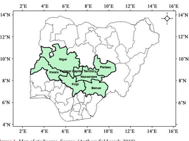
North central Nigeria lies approximately between 3˚ and 14˚E and latitude 7˚ and 10˚N. The region is made up of six states namely Benue, Kwara, Niger, Pla-teau, Nassarawa, Kogi and Abuja the federal capital Territory as shown in Fig-ure 1 [15].
It constitutes the food basket of Nigeria covering about 730,000 km2 or about 78% of the total land mass of Nigeria. It is bordered in the North by the republic of Niger in the east, by republic of Cameroon and in the west by Benin republic. The total population of north central Nigeria is over 20 million [16]. The relief of the north central region is dissected by hills, undulating plains and lowlands. Its valley and troughs which extend inland for 30 kilometers is made up of flood plains lying generally below 250 meters. In terms of drainage, north central Ni-geria has an excellent network of drainage network. This extensive drainage forms tributaries that flow from the Benue River and River Niger.
[image:3.595.212.534.479.719.2]The climate of the region is partly influenced by climates in the northern and southern region of Nigeria. The tropical savannah climate characterized by wet and dry condition affects most parts of north central Nigeria. Rainy seasons de-cline correspondingly in length as one move northward. Temperature is gener-ally high in the region. This is mainly due to the fact that the region lies within the tropics where the apparent movement of the sun is limited. In terms of rela-tive humidity, there is also a mark variation in the study area with relarela-tive hu-midity ranging from 60% - 80% [17]. The major vegetation of the North central region of Nigeria is basically the Guinea Savannah Zone which occupies same 90% of the land mass. This vegetation belt is mainly of deciduous trees with grasses and shrubs [18]. The soils of the region are generally characterized by a sandy surface horizon overlying a weakly structured clay accumulation.
DOI: 10.4236/acs.2019.92013 194 Atmospheric and Climate Sciences In terms of geology, the region is characterized by deep Sedimentation which commenced with the marine Neo-comain—Albia Asu River group. The Asu River Group sediments in the region comprises predominately of shale’s with localized sandstones, silts stones and limestone as well as extrusive and intrusive material of the Abakaliki formation in the Abakaliki area and the Mfamosing li-mestone in the Calabar frank [19].
3. Materials and Method
To examine the variability of rainfall using geospatial techniques, The point grid pattern of meteorological data was obtained for total precipitation from 2000 to 2017 from https://gisclimatechange.ucar.edu/gis-data. The point data of each of rainfall were clipped to the shape file of Nigeria Boundary and thereafter inter-polation using Inverse Distance Weight (IDW) was done to generate values of climate data for the unsampled places. IDW assumes that each measured point has a local influence that diminishes with distance. The shape file of the study area (North Central States) was further used to delineate the raster format of each of the climate data. Zonal statistics were used to extract the mean values of total precipitation after which spatial maps were generated on three year interval 2000-2003, 2003-2006, 2006-2009, 2009-2011, 2011-2013, 2013-2016 and 2017.
4. Results and Discussion
The result of the analysis is presented below:
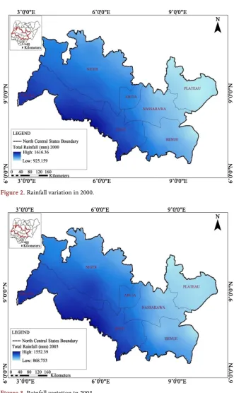
The geo spatial analysis of rainfall for all the stations in the study area for year 2000 is presented in Figure 2. The low rainfall value of 925.159 mm represents areas experiencing declining rainfall trend. In the analysis under review, these low rainfall areas are Plateau, Benue, Nassarawa, northern part of Niger state and the federal capital territory Abuja.
Similarly, the high rainfall value of 1616.36 mm is used to describe areas with sufficient rainfall amount. Again, these areas are Kogi, Ilorin and southern Niger states.
The down ward rainfall trend in plateau, Nasarawa and Benue and Niger states may be disastrous for the water resources and agricultural sectors and another indicator of drought risk assessment.
In 2003, annual rainfall performance for the rainfall abundant areas was 1552.39 mm while low rainfall areas recorded only 868 mm annual in the same year as shown in Figure 3. Like the preceding year, the states affected by low rainfall amount are Plateau, Benue, Nassarawa and parts of northern Nigerstates. This implies that there was early retreat, late onset and reduced duration of the raining season.
The result further reveals high variation in rainfall between the rainfall abun-dant areas and the regions with continuous decline in rainfall which signpost in-crease risk of drought especially the low rainfall areas.
DOI: 10.4236/acs.2019.92013 195 Atmospheric and Climate Sciences Figure 2. Rainfall variation in 2000.
Figure 3. Rainfall variation in 2003.
1605.82 mm was recorded for the high rainfall areas while an improved rainfall value of 907.136 mm for Plateau, Benue, and Nassarawa states. The result lends credence to previous studies by [20] that rainfall is generally retreating in parts of the North Central Region of Nigeria. Early cessation, late onset of rainfall of and shortened rain days are evidence of drought vulnerability.
DOI: 10.4236/acs.2019.92013 196 Atmospheric and Climate Sciences Figure 4. Rainfall variation in 2006.
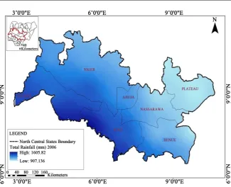
rainfall areas as the annual amount of rainfall received increased slightly from 907 mm in 2003 to 927.277 mm as shown in Figure 5. In the same vein, rainfall appreciated from 1605.82 mm in 2006 to 1624.13 mm in 2009 in the high rainfall areas.
The improved rainfall amount in 2009 implies sufficient soil moisture condi-tion, improved water supply, vegetal cover and high agricultural productivity in the region. As its expected farmers, took advantage of the improve rainfall con-dition and started the farming season much earlier recorded mark variation in rainfall with annual range of 0 - 994.58 mm. While the normal and increased rainfall signifies wet years and likelihood of flood occurrence, the low rainfall values and indicates dry spells and greater risk of drought.
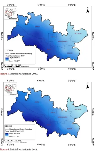
The result of the geospatial analysis in 2011 as shown in Figure 6 reveals a downward trend in rainfall in Plateau, Benue, Nassarawa and Abuja. The lowest rainfall for the aforementioned states is 852.357 mm compared to 907927.277 mm obtained in 2011 while 1513.71 mm of rainfall was recorded for the high rainfall areas. Of dry spells occasioned by fluctuating and declining rainfall continued to hold sway in major parts of the North Central States as shown in Figure 6.
The variation in annual rainfall recorded in 2011 summarily indicates that rainfall is on a steady decline in most of the states in the North Central.
This result lends credence to previous studies by [20] that rainfall is generally retreating in many parts of the North Central Region of Nigeria. Early cessation, late onset of rainfall of and shortened rain days are evidence of drought vulnera-bility.
DOI: 10.4236/acs.2019.92013 197 Atmospheric and Climate Sciences Figure 5. Rainfall variation in 2009.
Figure 6. Rainfall variation in 2011.
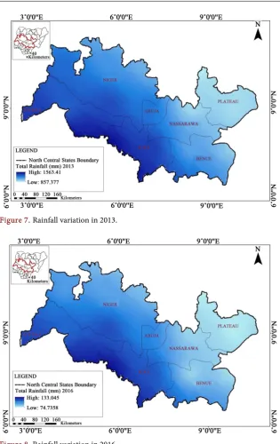
increase in rainfall intensity as the value rose from 852.357 mm in 2011 to 857.377 mm in the current year.
The implication of this result is that 2013 recorded prolong rainfall and flood especially in the high rainfall areas while the rainfall deficient areas continue to grapple with the menace of drought.
[image:7.595.214.534.62.322.2]DOI: 10.4236/acs.2019.92013 198 Atmospheric and Climate Sciences Figure 7. Rainfall variation in 2013.
Figure 8. Rainfall variation in 2016.
The reduced rainfall value of 74.7358 mm of rainfall is an indication of pro-long dry spell with attendant impact on crops and surface water availability. While people in the low rainfall areas are confronted with water scarcity, disrup-tions in the growing season and drought, the rainfall abundant areas experienced increased rainfall intensity with 133.045 mm as the maximum amount of rain-fall. This is expected to bolster food productivity and reduced water shortages.
The reasons adduced for the variability in rainfall mirrors the climatic condi-tions obtained in the Northern part of Nigeria and secondly the movement of the North easterly trade wind that prevails in the Northern region.
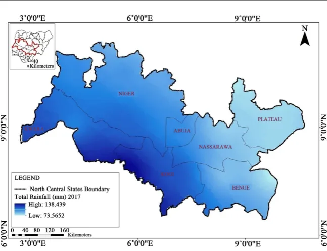
DOI: 10.4236/acs.2019.92013 199 Atmospheric and Climate Sciences Figure 9. Rainfall variation in 2017.
recorded the lowest rainfall value of 74.5652 mm particularly in the low rainfall areas. The result implies that the risk of drought was high in 2017 compared to previous years. On the other hand, rainfall was at its peak in the high rainfall areas with a value of 138.439 mm indicating an upward rainfall trend.
An assessment of the geo spatial analysis on rainfall trend presented in this study are in agreement with previous research findings by [21], on trend analysis of drought in the guinea and Sudan savannah regions. Also, attempts have been made in the past to investigate the influence of rainfall variability in Northern Nigeria [11] [12] [13] [14] [18] [22] [23] [24], and none used remote sensing and GIS to show how rainfall variability contributes to the vulnerability of the region to drought.
Assessment of the analysis reveals that while the North central region receives 2541.519mm of rainfall in 2000, only 212.0042 mm rainfall was recorded in 2017 in the region. Similarly, average annual rainfall variation during the period un-der investigation (2000-2017) remains 896.1 mm. This indicates that the trend of rainfall within the 17 years study period is on a downward trend and a negative change.
5. Conclusions
DOI: 10.4236/acs.2019.92013 200 Atmospheric and Climate Sciences in the climatic condition of the region which points to the stack reality of climate change.
The study is therefore a further contribution to knowledge on the efficacy of using geospatial techniques in studies of rainfall variability in Nigeria.
6. Recommendation
The following are some of the recommendations of the study:
More meteorological stations should be established in the region in other to
closely monitor the changing pattern and trend of rainfall fluctuation.
There is need to embark on robust education and enlightenment programs so
as to increase the awareness of the populace on the effect of declining rainfall trend on the agricultural and water resources sectors of the region.
Farmers should be encouraged to focus on irrigation and drought tolerant crops while government continues to scale up support to the agricultural sector.
Conflicts of Interest
The authors declare no conflicts of interest regarding the publication of this pa-per.
References
[1] IPCC (2007) Climate Change 2007: Impacts, Adaptation and Vulnerability. In: An-nex, I., Parry, M.L., Canziani, O.F., Palutikof, J.P., van der Linden, P.J. and Hanson, C.E., Eds., Contribution of Working Group II to the Fourth Assessment Report of the Intergovernmental Panel on Climate Change, Cambridge University Press, Cambridge, 976.
[2] Obot, N.I., Chendo, M.A., Udo, S.O. and Ewona, I.O. (2010) Evaluation of Rainfall Trends in Nigeria for Years (1978-2007). International Journal of the Physical Sciences, 5, 2217-2222.
[3] Sharad, J. and Vijay, K. (2012) Trends of Rainfall and Temperature Data for India. Journal of Current Science,102.
[4] Olatunde, A.F. (2012) The Intensity of Wet Years in the Sudano-Sahelian Region of Nigeria between 1941 and 2008. J. Environ. Sci., 6, 44-53.
[5] Mark, O. and Kishtawa, C.M. (2014) Spatial Analysis of Indian Summer Monsoon Rainfall.Journal of Geomatics, 8, 40-47.
[6] Kisaka, M.O., Mucheru-Muna, M., Ngetich, F., Mugendi, D. and Mairua, F. (2015) Seasonal Rainfall Variability and Drought Characterization: Case of Eastern Arid Region of Kenya. In: Leal Filho, W., Esilaba, A., Rao, K. and Sridhar, G., Eds., Adapting African Agriculture to Climate Change, Springer, Cham, 53-71.
[7] Ideki, O. (2018) Vulnerability and Adaptation Strategies to Drought Risk in North Central Nigeria. Ph.D. Thesis Submitted to the School of Graduate Studies, Univer-sity of Port Harcourt, Port Harcourt.
[8] Tihahun, K. (2006) Analysis of Rainfall Climate and Evapotranspiration in Arid and Semi Arid Regions of Ethiopia Using Data over the Last Half a Century. Journal of Arid Environment, 64, 474-487.
DOI: 10.4236/acs.2019.92013 201 Atmospheric and Climate Sciences Onset, Cessation and Length of Growing Season for Western Kenya. Agricultural and Forest Meteorology, 148, 1123-1135.
[10] Sivakumar, M.V.K. (1991) Empirical Analysis of Dry Spells for Agricultural Appli-cations in SSA Africa. Journal of Climate, 5.
[11] Atedhor, G.O. (2016) Growing Season Rainfall Trends, Alterations and Drought Intensities in the Guinea Savanna Belt of Nigeria: Implications on Agriculture. Journal of Environment and Earth Science, 6. https://www.iiste.org/
[12] Okeke, C.T. (2015) Spatial and Temporal Analysis of Monthly and Annual Rainfall Distribution in North Central Nigeria. M.Eng. Research, Department of Civil Engi-neering, University of Ilorin, Ilorin.
[13] Anuforom, A.C. (2010) Demonstration and Assessment of Climate Change in Nige-ria and Development of Adaptation Strategies in the Key Socio-Economic Sectors: Meteorological Approach. National Stakeholders Workshop on Developing Nation-al Adaptation Strategies and Plan of Action for Nigeria, 22 March 2010.
[14] Odjugo, P.A.O. (2010) Regional Evidence of Climate Change in Nigeria. Journal of Geography and Regional Planning, 3, 142-150.
[15] Utser, J.T. and Aho, M.I. (2012) Water Shortage and Health Problems in Benue State Nigeria. Impacts and Prospects for Solutions. International Journal of scientif-ic and Technology Research,1, 79-85.
[16] National Bureau of Statistic (2012) Social Statistics in Nigeria: Part III, Health, Em-ployment, Public Safety, Population and Vital Registration. NBS Abuja, Nigeria. [17] Binboll, N.L., Adebayo, A.A. and Zemba, A.A. (2015) A Measurement of Drought-Crop
Relationship in Northern Nigeria. University of Jos Institutional Repository. [18] Idoko, M.O. (1998) Sectoral Water Demand and Consumption in Markurdi, Benue
State. M.Sc. Thesis, School of Graduate Studies, University of Nigeria, Nsukka. [19] Aper, J.A. (2006) Stream Discharge Characteristics in the Lower Benue Drainage
Basin. Ph.D. Thesis, School of Graduate Studies, University of Nigeria, Nsukka. [20] Anufurom, C.A. (2009) Climate Change Impacts in Different Agro-Ecological
Zones of West Africa. Humid Zones.
[21] Omonijo, T.O. and Okogbue, E.C. (2014) Trend Analysis of Drought in the Guinea and Sudano-Sahelian Climatic Zones of Northern Nigeria (1907-2006). Atmos-pheric and Climate Sciences, 4, 483-507.https://doi.org/10.4236/acs.2014.44045 [22] Olaniran, O.J. (2002) Rainfall Anomalies: The Contemporary Understanding. 55th
Inaugural Lecture Series, University of Ilorin, Ilorin, Nigeria.
[23] Alatise, M.O. and Ikumawoyi, O.B. (2007) Evaluation of Drought from Rainfall Da-ta for Lokoja. A Confluence of Two Major Rivers. Electronic Journal of Polish Agricultural Universities (EJPAU), 10.