Article
1
Characterization of the Main Naturally-Radioactive
2
Geologic Units of Stara Planina
3
Sanaa Masod Abdulqader 1, Boris Vakanjac 2,*, Jovan Kovačević 3, Zorana Naunović 4 and
4
Nevena Zdjelarević 5
5
1 Singidunum University, Faculty for Applied Ecology “Futura”, Belgrade, Serbia;
6
7
2 Singidunum University, Faculty for Applied Ecology “Futura”, Belgrade, Serbia;
8
9
3 Geological Survey of Serbia; [email protected]
10
4 University of Belgrade, Faculty of Civil Engineering, Serbia; [email protected]
11
5 Nuclear Facilities of Serbia; [email protected]
12
* Correspondence: [email protected]; Tel.: +38163233637
13
Abstract: Stara Planina is known for numerous occurrences and deposits of uranium and associated
14
radionuclides. It is also famous for its geodiversity. The geologic framework is highly complex. The
15
mountain is situated between the latitudes of 43° and 44° N and the longitudes from 22°16′ to 23°00′
16
E. Uranium exploration and radioactivity testing on Stara Planina began back in 1948. Uranium has
17
also been mined in the zone of Kalna, within the Janja granite intrusive. The naturally-radioactive
18
geologic units of Stara Planina are presented in detail in the paper.
19
Keywords: geology; radioactivity; uranium; sampling; Stara Planina
20
21
1. Introduction
22
The objective of the paper is to provide an overview of the naturally-radioactive geologic units
23
in known areas of the Stara Planina Mountain (also known as the Balkan mountain range). The
24
studied localities include Mezdreja and Gabrovnica (abandoned mines in the Janja granites),
25
graphitic schists of the Paleozoic “Inovo Series”, and Early Triassic sedimentary units in the Dojkinci
26
– Jelovica area. These occurrences are known and have been described in papers, reports and books,
27
largely from the perspective of mineral exploration, origin or ecology. The paper aims to
28
characterize naturally radioactive units, with regard to their location, macroscopic and microscopic
29
features, chemical composition, and radioactivity of a specific sample determined both in situ and in
30
the laboratory. In other words, the objective is to provide answers to the questions: Which are the
31
particular geologic units, what are their petrologic, mineralogic, geochemical and radiometric
32
characteristics, and how did they come about? The paper presents the outcomes of research
33
conducted in the part of Stara Planina in Serbia.
34
2. Methodology
35
1. The samples were collected on pre-determined locations. The goal was to find representative
36
samples of naturally radioactive rocks. The sampling points are shown in the UTM system, zone
37
34N, ellipsoid WGS84.The weight of the samples was from 2 to 2.5 kg.
38
2. Thin sections were made from granite and schist samples, and where ore minerals were
39
detected polished sections were also made. The samples were viewed macroscopically and
40
microscopically on a Leitz Ortholux Pol 2 microscope at the Geological Survey of Serbia. The
41
structure of the samples was examined using a Bresser binocular magnifier.
42
3. On the ground, the radioactivity of the terrain and at the observation points was measured by
43
a Radiation Detector Explouranium 110 in cps and Gammascout in µSv/h. The results are included
44
in the descriptions of the tested samples. The values were recorded after a period of 10 minutes,
45
when they stabilized on the display and when there were no ±10% fluctuations. The data is
46
presented in the paper in intervals characteristic of the tested location.
47
4. Chemical analyses of powder were performed on an XRF Niton Xl3t Goldd+ analyzer at the
48
University of Belgrade, Faculty of Civil Engineering. Each sample was tested two or three times, for
49
about 180 to190 seconds in the Soil mode, and checked by Test Allgeo. The samples were ground to
50
70 µm. Some of the samples were analyzed in their solid state, for example schist; assays were
51
performed on plate and schistosity in resection. The following elements were measured: Mo, Zr, Sr,
52
U, Rb, Th, Pb, Au, Se, As, Hg, W, Cu, Ni, Co, Fe, Mn, Ba, Sb, Sn, Cd, Pd, Ag, Nb, Bi, Re, Ta, Hf, Cr, V,
53
Ti, Ca, K, Sc, S, Cs and Te.
54
5. The radioactivity of the samples (226Ra, 232Th, 40K and 137Cs) was measured at Vinča
55
Nuclear Institute. Homogenized samples were dried in an oven at 105ºC to constant weight, placed
56
in plastic Marinelli beakers, sealed and left for four weeks to reach radioactive equilibrium [1]. Each
57
prepared sample was placed in an HPGe detector and measured for 90 000s. Gamma background in
58
the laboratory was determined prior to testing, by measuring an empty Marinelli baker under
59
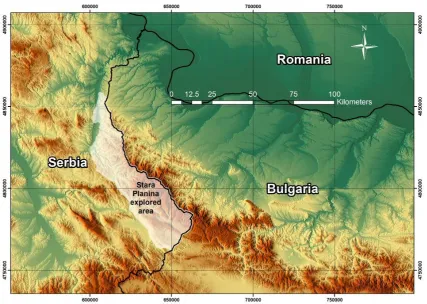
identical conditions. The counting time for background measurement was 240 000s. It was later
60
subtracted from the measured gamma spectra of each sample.
61
The activity of the samples was measured using a high-resolution coaxial semiconductor
62
detector with high-purity germanium crystal HPGe ORTEC GEM 50 and 50% relative efficiency at
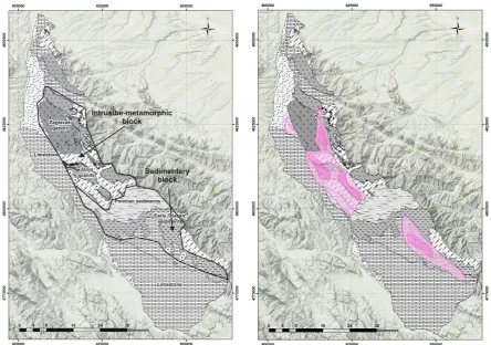
63
1332 keV. The detector was shielded by lead in order to achieve the lowest possible background
64
level.
65
Energy and efficiency calibration was undertaken before measurement. The calibration source
66
used was a commercially available gamma standard, with mixed radionuclides-type MBSS 2 in
67
Marinelli geometry of 0.5 l, developed by the Inspectorate for Ionizing Radiation of the Czech
68
Metrological Institute, with the isotopes: 241Am, 109Cd, 57Co, 139Ce, 113Sn, 85Sr, 137Cs, 88Y,
69
203Hg, and 60Co. The energy of gamma lines of these radionuclides is highly suitable for calibration
70
and covers the region of interest, i.e. from 30 to 3000 keV. Quality assurance of the measurements
71
was carried out by daily efficiency and energy calibration, repeating each sample measurement.
72
Correction for radioactive decay and background, as well as analysis of the results, were
73
conducted using dedicated software ORTEC Gamma Vision-32 Model A66-B32 Version 6.01.
74
The 226Ra activity was determined by its decay products: 214Pb (295.22 keV, 351.93 keV) and
75
214Bi (609.31 keV, 1120.29 keV). In the case of 232Th, two photopeaks of 228Ac (911.20 and 698.97
76
keV) were used. The activities of 40K and 137Cs were derived from 1460.83 keV and 661.66 keV
77
gamma lines, respectively.
78
79
3. Summary of uranium exploration in Yugoslavia (1948-1990) and on Stara Planina
80
81
Collection of data on natural radioactivity in the former Yugoslavia began in 1948 at the
82
national Geological Institute (Geoinstitute). Among voluminous data on the radioactivity of rocks,
83
waters (groundwater and surface water resources), soils, alluvions (recent riverine sediments), and
84
air, most are in their original or a certain type of interpreted form (such as statistical data), preserved
85
in annual or periodic geological exploration reports, studies, papers, publications, and the like. They
are accessible from the archives of Geoinstitute – now the Geological Survey of Serbia, but it is a
87
challenge to unify and covert the data into current units, given that the units have since been
88
changed several times.
89
Prospecting and exploration of nuclear minerals in Serbia, at different levels of detail,
90
encompassed large areas. The number of data points is of the order of several hundred thousand. So
91
far, the most extensive exploration was conducted in the geographical region of Šumadija (Mt.
92
Bukulja zone), on Stara Planina, and in the areas of Mt. Cer and Mt. Iverak, where uranium deposits
93
have been identified and reserves estimated.
94
Uranium exploration on Stara Planina began in 1949. Extensive slick probe prospecting and
95
walk-over radiometric prospecting were undertaken from 1949 to 1956. Geologic maps were
96
produced on a scale of 1:50,000, and within the zones of the Aldina River and Mezdreja on a scale of
97
1:10,000. In late 1956 [2], vein bodies were explored on the Mezdreja locality. Between 1957 and 1966,
98
a geologic-structural map was produced of the Janja granite and exploration conducted of the
99
sediments of the so-called Colorful Series, of the dispersion aureoles on the Mezdreja locality and
100
later, of the geological-mining operations at Gabrovnica and Mezdreja. Exploration was suspended
101
from the early 1970’s to 1978, and from 1978 to the early 1990’s it was generally conducted within the
102
area of the Colorful Series and in the fault zones of the Janja granite.
103
Since 2000, there has been non-systematic/thematic exploration, generally of radioactivity and
104
its impact on the environment on certain localities on Stara Planina [3-5] (also methodology in Bai et
105
al. 2017, was considered for future work [6]).
106
107
4. Location of Stara Planina and summary of geology
108
109
Stara Planina can be viewed from several perspectives, as a nature park and in terms of
110
geography, geology and geodiversity. The present paper addresses areas of interest from the
111
viewpoint of radioactivity. From the east (ridges) and south, the area is bounded by the border with
112
Bulgaria and from the west (north to south) by several rivers: the Beli Timok, the Trgoviški Timok,
113
the Stanjanska, the Klajča, the Temska and the Nišava. In general terms, only a small part of the
114
mountain range is located in Serbia. The remainder is in Bulgaria and extends all the way to the
115
Black Sea (Figure 1).
Figure 1. Form of Stara Planina and schematic representation of its extension into Bulgaria (whitish). Raster background is Relief (maps-for-free).
118
On the base geological map of the former Yugoslavia (scale 1:100,000), the area of interest is
119
depicted in the sections on: Bor, Zaječar, Knjaževac and Belogradcig [7], Pirot and Breznik [8]. On the
120
geological map of the Republic of Serbia, on a scale of 1:200,000 [9], the area of interest is shown in
121
the sections on Knjaževac-Zaječar and Priština-Niš. Both maps were used to produce overview
122
schematic maps of the geologic units discussed in the paper (Figure 2).
123
Generally speaking, Stara Planina is a complex geologic system, built up of different geologic
124
units (with regard to the composition, characteristics and origin). From the north, where the geologic
125
units are separated by structures and where granite and granodiorite intrusions begin, the area is
126
defined by faults that separate the Late Jurassic in the south from the Early Cretaceous in the north.
127
Towards the south, there is a complex geotectonic assemblage made up of the Janja (Figure 2),
128
Radičevo and Ravno Bučja granites; the Zaglavak gabbro massif; Paleozoic metamorphic rocks:
129
Proterozoic-Cambrian, Silurian-Devonian – the Inovo Series and others; and Permian red sandstones
130
and conglomerates. To the south, there are Mesozoic formations: Triassic (Kopren-Gostuša-Dojkinci),
131
Jurassic (Basara, Odorovci), and Early Cretaceous (Visočka Ržana, Dimitrovgrad). In the southern
132
part of the Mesozoic block the Jurassic and the Cretaceous are intersected by structures running
133
from the northwest to the southeast. The northern boundary of Stara Planina is not clearly defined
134
and can be followed on the Zaječar and Bor maps along Cretaceous formations and intrusions over a
135
length of about 30 km northward and farther via Brusnik and Brestovac to Negotin, but this is not
136
the subject of the present paper.
Figure 2. Characteristic geological units and landmarks in the study area on Stara Planina with legend for Figures 2, 3, 4 and 5. Raster background for Figures 2, 3, 4 and 5 is SASlanet, Google w/o names. White circles with dots are observation and sampling points.
139
In 1997, Stara Planina was designated a nature park, where there are a number of unique
140
examples of geodiversity.
141
142
5. Uranium occurrences and deposits on Stara Planina
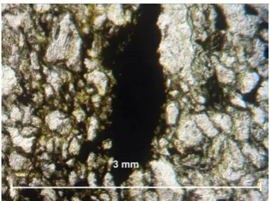
143
144
The following genetic types of uranium deposits and occurrences can be distinguished on Stara
145
Planina after Gertik 2003 [10] and Kovacevic 2006 [2]: 1. Uranium mineralizations in pegmatites, 2.
146
Uranium mineralization related with auto-metasomatic hydrothermal processes in granite, 3.
147
Sedimentary - infiltration deposits and occurrences, 4. Metamorphogenic occurrences.
148
The maps in Figures 3 and 4 include a schematic representation of the geology and distribution
149
of radioactivity on Stara Planina. In general terms and based on Geoinstitute’s activities [2] over
150
several decades, two levels of radioactivity have been identified: (1) about 200 cps, divided into three
151
zones whose total surface area is 307.5 km2, and (2) greater than 200 and up to 500cps (mostly greater
152
than 200 cps but rarely 500 cps), divided into four zones whose surface area is 70.84 km2.
153
In essence, the main sources of radioactivity on Stara Planina can be classified as: 1. Granitic
154
endogenous – syngenetic-epigenetic deposits and occurrences, 2. Metamorphogenic – syngenetic,
155
and 3. Sedimentary, including occurrences of uranium deposition and fluctuation caused by water
156
in different types of sedimentary rocks formed in a continental setting, which could be classified
157
under epigenetic types.
158
The occurrences described in this paper can also be grouped into two geological-structural
159
blocks [11, 12] (Figure 3): A. an intrusive-metamorphic block, and B. a sedimentary block.
A. In the intrusive-metamorphic block, the elevated radioactivity is associated with the Janja
162
granite and Aldinac grandiorite porphyritic rocks, as well as graphitic schists of the Inovo Series,
163
over a surface area of about 195 km2.
164
B. The radioactivity in the sedimentary block is associated with both secondary deposition of
165
minerals and reddish Fe-rich cement. Elevated radioactivity has particularly been noted at points of
166
contact between gray and red siltstones, where the gray have been deposited as lenses of different
167
sizes in the basal reddish mass of continental sediments. The surface area is approx. 97 km2.
168
169
Figure 3. Schematic representation of geologic units and intrusive-metamorphic and sedimentary blocks of Stara Planina.
Figure 4. Zones of elevated radioactivity, measured in cps (light pink – 200 cps and above, and dark pink up to 500 cps).
170
171
6. Geologic, geochemical and radiometric characteristics of the Janja granite at Mezdreja and
172
Gabrovnica
173
174
The Janja granite massif is located south of the Zaglavak gabbro massif and west of the Ravno
175
Bučja granite (Figures 2, 5). It is elongated in the northwestern-southeastern direction. The Janja
176
granite is about 19 km long and 2.5 km wide.
177
The Janja granite massif is pressed into Late Proterozoic and Cambrian crystalline schists. The
178
crystalline schists feature thermo-contact and metasomatic alterations. The primary structural
179
elements include fractures filled with aplite, pegmatite and quartz veins. In places, the fractures
180
trending NW-SE, concentrated on the fringes of the massif, exhibit sericite crystallization.
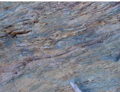
181
In its northwestern part, the massif splits into two masses separated by amphibolites,
182
amphibole schists, gneisses and mica gneisses. Peripherally there are contact alterations manifested
183
by silification, biotitization and local deposition of feldspar [7]. There the massif is contaminated by
granitoid magma, evidenced by an increasing content of biotite and sphene and decreasing content
185
of K-feldspar and quartz. The Janja granite is generally of the normal calc-alkaline type, which on the
186
fringes turns into the monzonite-akerite type and in the central part into alkaline granite.
187
Deformations and secondary alterations have been noted in the entire massif, particularly on the
188
fringes. They are represented by a schistose texture, crushed minerals and crystallization of
189
secondary minerals. The primary components are quartz, oligoclase, K-feldspar (microcline, rarely
190
orthoclase), and biotite. The accessory components are sphene, apatite, zircon and magnetite, and
191
the secondary components sericite, chlorite, epidote, calcite, limonite and a clayey substance. There
192
are syenite diorites in the periphery of the Janja granite and on its fringes. Their origin is attributed
193
to contact-metasomatic processes in the syenite diorites.
194
Pegmatite veins are made up of quartz, plagioclase (albite-oligoclase) enriched with U [13],
195
microcline, biotite and muscovite. The accessory components are apatite, zircon, alanite and metallic
196
minerals. There are quartz veins inside and around the massif. Their thickness is up to several
197
meters and they are up to 200 m long. In addition to quartz, they contain tourmaline and metallic
198
minerals.
199
Typical naturally-radioactive geologic representatives were tested within the Janja granite.
200
Samples of granite, the host rock at Mezdreja and Gabrovnica, were of primary interest. In addition
201
to granite, tailing dump samples from Mezdreja (clayey material with cataclazed granite fragments),
202
silicified batches with limonite stains and fragments of contact gabbroid with coarse (1.5 cm)
203
K-feldspar were examined.
204
Detail information about granite and radioactivity in general are in [14-16].
205
206
Figure 5. Map of Mezdreja and Gabrovnica (including the Inovo metamorphic rocks area) within the Janja granite, along with control points (black dots).
Mezdreja mine area
210
Mezdreja is located in the southern part of the Janja igneous metamorphic complex. It is defined
211
by two fault zones, so-called zones 0 and 1 [10].
212
Fault zone 0 trending NW-SE is 1300 m long and has vertically been explored from 200 to 600 m.
213
The following zonality has been noted in the vertical profile: kaolinized, sericitized and chloritized
214
zones in the upper parts, and silification, pyritization and hematitization in the lower parts. The ore
215
is developed in the form of lenses that locally form columns. Uranium mineralization is finely
216
dispersed in crushed and hydrothermally altered granite or in the form of veinlets, coatings and
217
stains of pitchblende visible to the eye. Non-uranium-bearing parts of the fault zone are filled with
218
sericite and chalcopyrite. Fault zone 1 is developed adjacent to metagabbroid rocks (Figure 10). The
219
form and extent are similar to those of Zone 0. Mineralization is of the vein/lens type at the point of
220
contract with the metagabbros. Along Zones 0 and 1 there are biotite granites and metamorphic
221
gabbros. Uranium is mineralized in the form of impregnations of veinlets and stains, and is
222
represented by pitchblende and secondary pitchblende.
223
Four samples were acquired from the Mezdreja site:
224
1. A granite sample was collected near the pit (Figure 6) and radioactivity measured by GR110
225
in situ was 520 cps at the sampling point and 420 cps and 0.322 µSv/h at the mine portal. The pit has
226
caved and could not be accessed. The rock is partially fractured. The predominant components are
227
pink K-feldspar and white plagioclase, both fractured and sericitized and kaolinized to different
228
degrees. The dimensions were up to 0.5–1.5 cm (Figure 7). There was also chloritization, occasionally
229
accompanied by magnetite grains developed at a later date during short hydrothermal or
230
auto-metasomatic episodes.
231
232
Figure 6. Granite sample collected near the Mezdreja mine portal.
Figure 7. Macro image of a polished granite sample collected at the Mezdreja mine portal, including pink K-feldspar and white plagioclase.
233
2. In the area between the mine portal and dump, there were small outcrops of silicified
234
material with occurrences of ore impregnation and limonitization (Figure 8). Radioactivity
235
measured 320 cps and 0.182 µSv/h.
236
3. The mine dump contained crushed granite material – clayey, kaolinized and chloritized
237
(Figure 9). Radioactivity measured up to 1250 cps and 0.421 µSv/h.
Figure 8. Silicified rock (vein) with ore minerals and alterations.
Figure 9. Fragments of granite and clayey material from the Mezdreja mine dump.
240
4. A sample with large pink K-feldspar was collected from the point of contact between granitic
241
and gabbroid rocks. Radioactivity measured 120 cps and 0.192 µSv/h. The K-feldspar shown in
242
Figure 11 was separately tested by XRF. The results are shown further below.
243
244
Figure 10. Macro image of a polished sample of a gabbroid outcrop from Mezdreja.
Figure 11. Gabbroid K-feldspar – pinkish; the metallic yellow in the middle is an idiomorphic grain of pyrite.
245
Gabrovnica mine area
246
The origin of the deposits is similar to that of Mezdreja. The only difference is that there are
247
eight fault zones that can be divided into two groups: (1) diabase dikes in granites and milky white
248
quartz, and (2) crushed granites. Uranium ore is developed in chloritized phyllonites and crushed
249
granites. Solid and non-tectonized batches are sterile or contain little ore. The fault zones are highly
250
tectonized by post-ore tectonics. The origin of the uranium is similar to that at Mezdreja.
251
Fresh granite near the pit and granite (Figure 13) from the mine dump were sampled as
252
representative of the locality. Radioactivity measured 240 cps and 0.210 µSv/h at the mine portal
253
(Figure 12) and 360 cps and 0.248 µSv/h at the mine dump.
Figure 12. Gabrovnica mine portal. Figure 13. Macro image of a polished granite sample from Gabrovnica, containing pinkish K-feldspar and white plagioclase.
256
Origin of uranium in Mezdreja and Gabrovnica mines
257
In the endogenous group, specifically in the case of the Mezdreja and Gabrovnica granites and
258
ore deposits, feldspar and mica minerals are the most important in terms of uranium concentrations.
259
Given that the concentrations of uranium in the main petrogenic minerals are rather low, and the
260
total amounts of such minerals and their spread large, they represent sources from which “hot”
261
granites leach considerable concentrations of uranium. Uranium occurs as U4+ in biotite, muscovite
262
and minerals from the feldspar group. If these minerals have been altered under the influence of
263
oxygen-rich hydrothermal or meteoric waters [17], uranium in the form of U6+ (as the U6+O2 ion)
264
might be present in them, as well as in accessory minerals: sphene, zircon, monazite, ortite,
265
xenotime, apatite, tourmaline, apatite [18] and others.
266
Since uranium is remobilized from the primary granite at Mezdreja and Gabrovnica, it should
267
be noted that in the presence of water and the H+ ion: (1) kaolinite, the K+ ion, U4+ – uranium ion and
268
orthosilicilic acid are created from the primary “uranium-bearing” K-feldspar, and (2) sericite, K+
269
ion, UO22+ – uranyl ion and again orthosilicilic acid might be formed. Sericitization has been
270
observed in petrologic samples from Mezdreja and Gabrovnica (Figures 14 and 15). In the samples
271
collected as part of the present research, sericitization was more pronounced at Mezdreja than at
272
Gabrovnica.
273
274
Figure 14. Microscopic image of the sericitization of a sample from Mezdreja.
Figure 15. Microscopic image of the sericitization of a sample from Gabrovnica.
Biotite, another primary “uranium-bearing” mineral in granite, can also be transformed in two ways:
277
(1) when the negative OH- ion is present, creating sericite, silicon dioxide, water, aluminum silicate
278
(which may occur as andalusite, kyanite or sillimanite), K+ ion and U4+ uranium ion, and (2) in the
279
presence of water and the H+ ion creating sericite, aluminosilicate, K+ ion and UO22+ – uranyl ion.
280
281
7. Geological, geochemical and radiometric characteristics of samples of black graphitic schists
282
from the Inovska River
283
284
The Inovo Series transgresses the southwestern part of the Janja granite-metamorphic system.
285
Metaconglomerates and metasandstones are the base of the metamorphic-sediment batch. They are
286
overlain by metasandstones containing argillophyllites, with schists in the upper part. The sequence
287
is built up of chlorite-phyllite schists, green schists, amphibolites, graphitic schists, greywackes and
288
conglomerates [7].
289
The Inovo Series graphite-bearing schist is located in relative proximity to the Gabrovnica mine,
290
2.5 km southeast and 1.3 km southwest of the closest mapped point of the Janja granite (Figures 2
291
and 3).
292
The Inovska River occurrence is situated in the river (on the riverbanks), developed in fractured
293
and altered brecciated metasandstones with interbeds and lenses of black graphitic schists (Figure
294
16), 50 to 70 m thick.
295
The upper part of the batch contains layers of coarse-grained and fine-grained metasandstones
296
with black clayey schist intercalations. In the lower part there are brecciated arkose metasandstones.
297
The package dips to the northeast at an angle of 70 to 80o.
298
Uranium is mineralized in the form of elongated lenses in the direction of the dip, following
299
layers of metasediments between coarse-grained metasandstones and black clayey schists [10]. The
300
lens-like ore body runs along the dip to about 30m. Ore bodies are built up of carbonitized,
301
pyritized, chloritized and sericitized microconglomerates to arkose sandstones with traces of
302
chalcopyrite and galenite.
303
A number of samples were collected. Those shown here contain a little and a lot of graphitic
304
material. Niton XRF Goldd+ analyses showed that the sample with more graphitic material carried a
305
larger amount of uranium. Also, that sample was brittle, with limonitic stains (Figure 17) along the
306
directions of shearing. Radioactivity at the sampling site measured 650 cps and 0.279 µSv/h.
307
308
Figure 16. Outcrop of graphitic schist at the Inovska River.
Figure 17. Limonitized batches (brownish) and quartz veins (top right next to the hammer).
With regard to the thin sections, the lighter and harder variety had more petrogenic minerals
311
and less graphitic material, and also contained limonitic stains (Figures 18 - 21).
312
313
Figure 18. Graphitic schist of the Inovo Series, with less organic material. The break is sharp. Limonitic stains can be noted on tectonized parts. In the upper part of the sample there is a lens with quartz and silicified material.
Figure 19. Thin section of the sample with less organic material. Obj.8x//N.
314
Figure 20. Graphitic schist of the Inovo Series, with more organic material, showing obvious stratification and limonitization.
Figure 21. Thin section of the sample with more organic material. Graphitic material is concentrated in the middle (black). Obj.8x//N.
315
Elevated concentrations of uranium in these metamorphic rocks are a result of redistribution of
316
ore components under dynamic-thermal metamorphism conditions.
317
Since these two samples were collected in relative proximity and their alterations varied at a
318
decimeter level, radioactivity was measured at the Vinča Institute lab, using homogenized samples
319
of the two varieties of graphitic schists of the Inovo Series.
320
321
8. Geological, geochemical and radiometric characteristics of the Colorful Series
322
323
The observation points within the Colorful Series are located in an area defined as Early
324
Triassic. Known places where elevated uranium concentrations have been detected are in the part of
325
the terrain called Dojkinci – Jelovica (Figure 2). The area is known as that of “clastic rocks of Stara
326
Planina”, a formation that features clearly defined continuous sedimentation in continental warm
327
and humid climate conditions. The geology is represented by continental formations built up of
328
fragments of crystalline schists and granites, light-red quartz conglomerates, red and gray
329
sandstones, and gray to grayish-pink siltstones [8]. The upper part of the Colorful Series includes
330
Middle Triassic marls and sandy limestones. Uranium mineralizations are usually found in the form
of pitchblende [2]. The color of the sandstones varies from red – usually (Figures 24 and 25) to
332
greenish – rarely. All siltstones exhibited elevated concentrations of uranium. From the north, the
333
Early Triassic (Permo-Triassic) sediments of the Colorful Series are in contact with Ripheo-Cambrian
334
schists. The regional metamorphism of these rocks corresponds to a green schist facies. There is
335
distinct foliation and the color is typically grayish-green (Figures 22 and 23). The alterations have
336
been influenced by granodiorites, a small portion of which are in Serbia and the majority in Bulgaria
337
[8]. In particular, samples of quartz veins form this unit measured 6 ppm of gold. A low/insignificant
338
level of radioactivity was detected.
339
340
Figure 22. A block of green schists 300 m northeast of the sampling point Sandstone_red1 from T1 (Table 4).
Figure 23. Typical appearance of the green schists from Fig. 22. Whitish are quartz veins.
341
Microscopic examination of thin section as part of the present research revealed that a typical
342
sample of the Colorful Series sandstone was dark “hematite” red to pinkish-gray, with a psammitic
343
structure, built up of quartz, orthoclase, plagioclase, muscovite, biotite, apatite, epidote, chlorite and
344
fragments of metamorphic rocks. The grains were several tens to 100 and exceptionally 300 µm.
345
There is more orthoclase than plagioclase. The grains were highly altered into clay minerals and
346
sericitized. The plagioclases are sericitized as well as calcitized. The quartz, orthoclase and
347
plagioclase are angular. The micas exhibited linear orientation and locally built nest-like forms. The
348
apatite was rounded. Zircon was noted locally in the quartz. The epidote was developed as
349
independent entities. The cement are of the iron-carbonate type. The sample was collected as a
350
“representative” from the direction of contact with metamorphic rocks, before the gray siltstones.
351
The sampling point measured 120 cps and 0.172 µSv/h.
Figure 24. Typical outcrop of Early Triassic red sandstone from Jelovica.
Figure 25. Macro image of a freshly broken Early Triassic red sandstone from the Dojkinci-Jelovica area. Visible are mostly quartz grains and a reddish matrix.
357
By way of an explanation of the uranium concentrations in the red members of the Colorful
358
Series, it should be noted that the reduction of mobile uranium (U6+) to insoluble uranium (U4+), such
359
as uraninite, takes place when the fugasity of oxygen in solution drops. This reaction occurs on
360
account of iron or sulfur oxidation. When the solution (water) is rich in oxygen, bivalent iron will
361
oxidize into trivalent iron, but if there is an excess of Fe2+ relative to the oxygen, the oxygen will be
362
spent and the uranyl ion is the one to convert bivalent iron into trivalent, or sulfides to sulfates, and
363
is itself precipitated as uraninite. It is known in geology that iron oxidation in nature can result in
364
uranium-bearing hematite [19]. The typical red color is attributed to Fe hydroxides, largely
365
deposited as cement. Their widespread presence suggests considerable incoming Fe from the
366
Zaglavak gabbroids (granites carry a much smaller amount of Fe).
367
The sample of the gray siltstone is pelitic, fine-grained and compact. It is built up mainly of
368
clay-sericitic material. There was also fine sharp-edged quartz with thin plates of muscovite and
369
biotite, turning into an iron substance and chlorite. Rare metallic minerals and fragments of
370
coaly-organic material (Figure 27) were also found. The amounts of the gray siltstone were not large
371
and they were likely created from the sediments of small local lakes and wetlands. The sample of
372
gray siltstone was collected at the redox contact between the red siltstone and reddish sandstone
373
(Figure 26), where the grain sizes of the fragments increased from the sampling point to the substrate
374
(road level). Radioactivity in the redox zone measured 280 cps and 0.429 µSv/h.
375
376
Figure 26. Redox contact, elevated radioactivity of red and gray siltstones in the Dojkinci-Jelovica area.
Figure 27. Macro image of gray siltstones from the redox zone of the Early Triassic at Jelovica (black in the center is organic-coaly material).
Uranium concentrations in this case are attributable to adsorption to clays and organic-coaly
378
material (well described in Wang et. al 2015 [20]). This process takes place in the presence of specific
379
adsorbents such as clay minerals, limonite, carbonate sediments or organic substances – humic acid
380
or caustobiolites, with which the uranium-bearing solution comes into contact. Muto et al., 1968,
381
tested uranium adsorption to the clays commonly found in nature: montmorillonite, haloizite and
382
kaolin [21]. The results they reported show that uranium is fixed most efficiently at pH from 6.1 to
383
6.2.
384
In the Dojkinci area, pH measured about 7, locally 7.4. In addition, in the Dojkinci – Jelovica
385
area uranium migrativity and a reduction environment have been noted [22]. Uranium is being
386
deposited in a reduction environment, after the change of redox conditions. Organic substances are
387
the major reducers of uranium, followed by iron compounds and clay minerals [23]. In the zone of
388
the geochemical barrier in Permo-Triassic sediments, pH levels of water recently measured about 7
389
and Eh about 140 mV.
390
391
9. Discussion and results
392
393
The concentrations of U, Th, Pb, as Sr, Rb and K are presented in a from-to form, given that
394
measurements were repeated several times to obtain concentration ranges of powdered and solid
395
samples and to also check for any large variations. Before the results of chemical XRF analyses, the
396
Table 1 below shows the measured radioactivity of typical petrologic representatives.
397
398
Table 1. Radioactivity of characteristic petrologic samples from Stara Planina
399
Label Mass [g]
Activity concentration [Bq/kg]
226Ra 232Th 40K 137Cs Mezdreja_granite_mine1 524.30 142 ± 7 250 ± 10 1420 ± 60 < 0.4
Mezdreja_silicified_lim1 359.84 400 ± 20 188 ± 9 600 ± 30 < 0.6
Mezdreja_granite2 459.73 116 ± 5 230 ± 10 1020 ± 50 < 0.4
Mzdreja_clay_tailings1 554.85 2600 ± 100 169 ± 8 1240 ± 60 10.8 ± 0.5 Schist_graphitic_silicified1 505.77 220 ± 10 141 ± 7 1420 ± 60 < 0.4
Schist_graphitic2 439.11 380 ± 20 169 ± 8 900 ± 40 3.7 ± 0.2
Gabrovnica_mine1 552.72 58 ± 3 163 ± 8 1700 ± 80 2.3 ± 0.1
Gabrovnica_tailings1 603.55 206 ± 9 250 ± 10 1690 ± 80 4.8 ± 0.3
Siltstone_gray1 465.30 102 ± 5 97 ± 5 2080 ± 90 < 0.5
Sandstone_red2 495.80 28 ± 1 52 ± 3 1270 ± 60 1.6 ± 0.1
400
Before proceeding with the discussion of the results, the outcomes of the chemical tests are
401
presented in tabular form to show the geologic and radiometric characteristic of the tested petrologic
402
units.
403
404
9.1. Samples and assays of igneous rocks
405
406
The concentrations of uranium in the granite samples from Mezdreja and Gabrovnica are
407
presented in Table 2.
Table 2. Assays related to igneous rocks (values are in ppm)
411
Assays_igneos rocks U Th Pb Sr
Mezdreja_granite_mine1 12.37 36.63 53.03 636.69
Mezdreja_granite_mine2 14.39 60.27 42.39 827.62
Mezdreja_granite1 12.85 37.01 54.15 634.69
Mezdreja_granite2 12.21 55.44 44.68 840.98
Mezdreja _K-feldspar_plate 6.5 4.56 61.74 655.11
Mezdreja_K-feldspar_section 6.99 9.72 46.64 665.36
Mezdreja _silif_lim1 0 30.25 104.22 1962.7
Mezdreja _silif_lim2 0 28.42 94.31 1850.88
Mezdreja _clay_tailings1 76.54 52.91 97.48 590.66 Mezdreja _clay_tailings2 77.65 43.17 103.06 749.37
Gabrovnica_granite_mine1 13.8 32.99 67.75 308.1
Gabrovnica_granite_mine2 11.61 30.82 64.27 288.82
Gabrovnica_granite_tailings1 20.69 31.84 74.66 186.94
Gabrovnica_granite_tailings2 21.09 38.66 69.47 189.56
412
The concentrations of uranium in the granite samples from Mezdreja and Gabrovnica were
413
always lower by a factor of 3 to 4 than those of thorium. At Mezdreja, the uranium concentrations
414
varied from 12.21 to 14.39 ppm and those of thorium from 36.63 to 60.27 ppm. Radioactivity (226Ra
415
in Bq/kg) of the granites near the Mezdreja mine and at the mine portal measured 116 ± 5 and 142 ± 7,
416
while 232Th was 230 ± 10 to 250 ± 10 Bq/kg. At Gabrovnica, the concentrations of uranium were from
417
11.61 to 21.09 ppm and of thorium from 30.82 to 38.66 ppm. Here the radioactivity (226Ra) of the
418
granite samples from the mine portal area were 58 ± 3 and of the granite samples from the mine
419
dump 206 ± 9. The measured 232Th radioactivity of the mine portal granite was 163 ± 8 Bq/kg and of
420
the mine dump granite 250 ± 10 Bq/kg. Hence, in both cases (Mezdreja and Gabrovnica), the thorium
421
concentrations and radioactivity were higher than those of uranium. It should be noted that the
422
concentrations of Pb at Gabrovnica were somewhat higher – 64.27 to 74.66 ppm than at Mezdreja –
423
42.39 to 54.15 ppm.
424
Assays of coarse-grained pink K-feldspar sampled at Mezdreja, from the point of contact
425
between the gabbroids and granites, showed that the concentrations of uranium were low – 6.5 to
426
6.99 ppm, while those of Th varied from 4.56 to 9.72 ppm. The sample was a 2 cm solid grain, tested
427
at the basis and section. A high Th concentration was measured at the section. The lead (Pb)
428
concentrations were similar to those in the granite samples.
429
The concentrations of uranium in the clayey and kaolinized material from the Mezdreja mine
430
dump were higher than in fresh granites, but still lower than in the graphite-rich schists. The values
431
ranged from 76.54 to 77.65 ppm of U. In this case there was less Th than U; Th concentrations were
432
from 43.17 to 52.91 ppm. The concentrations of lead were nearly double those in granites, from 97.48
433
to 103.06 ppm. With regard to radioactivity, this material measured the highest equivalent values for
434
uranium 226Ra – 2600 ± 100 Bq/kg. The radioactivity of 232Th was 169 ± 2 Bq/kg and correlated with
435
the values measured in the Mezdreje and Gabrovnica granites. This particular sample exhibited the
436
highest radioactivity of 137Cs – 10.8 ± 0.5 Bq/kg, compared to all the other samples tested in the
437
research. In the granites, 137Cs measured 2.3 ± 0.1 at the pit and 4.8 ± 0.3 Bq/kg at the mine dump.
438
The values of 137Cs at Mezdreja were low – less than 0.6 Bq/kg. In clay minerals, U enrichments are
in illite bearing uranium ore from Baiyanghe [24], the uranium mineralization is located near the
440
fracture zone, which represents the center of hydrothermal fluid activity or mineralization as is
441
similar in case of Mezdreja mine.
442
No uranium (LOD) was found in a sample of silicified material from Mezdreja. The
443
concentration of thorium was from 28.42 to 30.25 ppm, and of lead from 94.31 to 104.22 (i.e. higher
444
than in the other endogenous products tested). It is interesting to note that this sample measured the
445
highest concentrations of cadmium (311.72 – 352.69 ppm) and palladium (5.5 – 6.2%). The
446
radioactivity of 226Ra was 400 ± 20 Bq/kg and of 232Th 188 ± 9.
447
A highly-silicified sample from Mezdreja (Fig. 18) measured the highest concentration of
448
strontium – from 1850.9 to 1962.7 ppm. In the samples from Mezdreja and of the monomineral pink
449
K-feldspar, the concentrations were from 634.69 to 840.98 ppm and from 655.11 to 665.36 ppm,
450
respectively. The Sr concentrations in the Gabrovnica granites were lower and ranged from 186.94 to
451
308.1 ppm.
452
453
9.2. Samples and assays of graphitic schists
454
455
The concentrations of U, Th, Pb and Sr in graphitic schists from Inovo series are presented in Table 3.
456
457
Table 3. Assays related to graphitic schists (values are in ppm)
458
Assays graphite schist U Th Pb Sr
Schist_graphitic1 99.47 42.01 107.69 88.88
Schist_graphitic2 20.99 19.29 51.55 115
Schist_graphitic_ silicified1 27.31 14.35 51.11 119.65 Schist_graphitic_ silicified2 14.69 27.06 47.33 244.78 Schist_graphitic_compopowder 12.52 20.66 50.42 237.61
459
The highest concentration of uranium was measured in the graphitic schist of the Inovo Series,
460
rich in graphitic (organic) material, and it amounted to 99.47 ppm, as opposed to the schist samples
461
from the same sequence that were richer in silicate material, which measured less uranium by a
462
factor of nearly 4 (20.99 to 27.31 ppm). The concentration of Th was generally lower than that of U.
463
The graphite-rich samples had nearly half the Th.
464
The samples that contained more silicate material had Th concentrations varying from the ratio
465
1:2 in favor of uranium to the same ratio in favor of thorium. The highest measured concentration of
466
Th was 42.01 ppm in a graphite-rich sample. The concentration of lead varied from 47.33 to 51.55
467
ppm and was similar to the lead concentrations in the granites, particularly at Mezdreja where
468
107.69 ppm of Pb was exceptionally measured in graphitic schists (which exhibited the highest
469
uranium concentrations). Radioactivity was measured in both cases. In the graphite-rich schist
470
226Ra was 380 ± 20 and in the graphite-poor schist 220 ± 10 Bq/kg, which correlated with the
471
concentrations of U measured by XRF. The radioactivity of 232Th in the graphite-rich schist was 169
472
± 8 and in the graphite-poor schist 141 ± 7 Bq/kg. The radioactivity of 137Cs was 3.7 ± 0.2 in the
473
graphite-poor sample.
474
It should be noted that home water well is 200 m approx. from observation point, in vicinity of
475
river and water should be tested for uranium as it was carried out in Montana [25].
The highest Sr concentrations were noted in the graphitic schists of the Inovo Series with less
478
organic material and the grade was 244.78 ppm.
479
480
9.3. Samples and assays of sedimentary rocks
481
482
The concentrations of U, Th, Pb and Sr in sedimentary rocks - colorful series from Jelovica area
483
are presented in Table 4.
484
485
Table 4. Assays related to sedimentary rocks (values are in ppm)
486
Sample U Th Pb Sr
Siltstone _gray1 49.36 11.83 11.85 95.84
Siltstone _gray2 49.94 12.46 11.59 92.71
Siltstone _redox1 54.43 13.13 12.34 96.74
Siltstone _redox2 52.02 12.88 16.13 93.59
Siltstone_redox_gray1 22.93 10.77 18.18 117.28 Siltstone_redox_gray2 29.31 13.7 16.45 110.23
Sandstone_red1 7.78 3.56 11.81 91.08
Sandstone_red2 12.64 4.76 10.35 51.46
Sandstone_red_orange1 8.7 3.42 10.94 47.29
Sandstone_red_orange2 9.15 9.25 8.42 97.77
Sandstone_orange 9.73 7.65 10.79 94.71
487
All the gray siltstones of the Colorful Series measured uranium concentrations from 49.36 to
488
54.43 ppm. In this case the concentrations of thorium were lower by a factor of about 4 – from 11.83
489
to 13.13 ppm. Lead concentrations were similar to those of Th and ranged from 11.59 to 18.18 ppm.
490
These samples exhibited somewhat elevated concentrations of Ba – from 590.14 to 603.42 ppm. The
491
radioactivity of 226Ra was relatively low (102 ± 5 Bq/kg) and 232Th measured 97 ± 5 Bq/kg. The
492
radioactivity of 40K was relatively high – 2080 ± 90 Bq/kg. The values of 40K of the other samples
493
were lower and ranged from 900 ± 40 to 1700 ± 80 Bq/kg (the lowest in the case of a highly silicified
494
sample with limonite stains collected near Mezdreja).
495
The red sandstones of the Colorful Series measured relatively low concentrations of uranium,
496
from 7.78 to 12.64 ppm, and of thorium from 3.42 to 9.25 ppm. Lead concentrations varied from 8.42
497
to 11.81 ppm. These samples measured the lowest radioactivity of 226Ra – 28 ± 1, and 232Th was 52 ±
498
3 Bq/kg.
499
In all sedimentary units the concentrations of strontium were much lower (in relation to granite
500
and graphite schist samples) and generally varied from 90 to 120 ppm.
501
502
10. Note
503
One of the major causes of elevation of naturally-occurring radionuclide material
504
concentrations on the Earth’s surface is mining [26]. All the above-mentioned occurrences can
505
conditionally be deemed natural. Still, the Mezdreja and Gabrovnica mine dumps carried
506
non-processed material. It is also a fact that these areas are relatively large and that the radioactive
507
material of the described samples is continuously drained into watercourses. Acoording Dragović et
al., 2007 [27], the total gamma dose rate in areas of Mezdreja and Gabrovnica is two times higher in
509
relation to the world average.
510
The samples shown in Figures 24 - 27 were collected next to a road. In Peng et. al 2016 [28] is
511
shown that the groundwaters from the oxidizing aquifer with high dissolved oxygen concentration
512
(O2) which is case for Jelovička and Dojkinčka rivers, and oxidation-reduction potential (Eh) are
513
enriched in U. The material from this and similar outcrops is regularly washed out by runoff after
514
heavy rainfall or snowmelt, into the Jelovička River (a tributary of the Dojkinačka).
515
There is widespread contamination of the environment due to natural and anthropogenic
516
enrichment of radionucleides in the world. In soil samples and alluvial deposits in Gabrovnica and
517
Mezdreja deposits, an increased concentration of uranium in relation to natural background values
518
were noted [29]. Also in Niger Delta [30] the highest activity concentration in all fish species of
519
gamma emitting radionuclides was observed for 40K, followed by 238U, 232Th and 226Ra. Exploring the
520
Gawib River floodplain in Namibia, Abive and Shaduka 2017 concluded that the radioactive
521
contaminants can spread into the deeper aquifer system through the major structures such as joints
522
and faults [31].
523
The study area was well known for livestock breeding and the production of cheese and meat,
524
especially between the two world wars. However, since the 1970’s the population has been
525
migrating to industrial centers. Now some of the villages are completely abandoned and the average
526
age of the sparse population of others is above 60. There has never been any systematic monitoring
527
of the impact of naturally elevated radioactivity on human and animal health, such that no data has
528
been compiled.
529
References
530
1. HASL-300, EML Procedures Manual, New York, 1983.
531
2. Kovačević, J. Metalogeny of Stara Planina Mt. region, 2006. Faculty of Mine and Geology, Belgrade, PhD
532
thesis (in Serbian).
533
3. Momčilović, M.; Kovačević, J.; Dragović, S. Population doses from terrestrial exposure in the vicinity of
534
abandoned uranium mines in Serbia, ELSIVER Radiation Measurements, 2008, 45 (2010) 225–230,
535
doi.org/10.1016/j.radmeas.2010.01.035
536
4. Todorović, D.; Radenković, M.; Popović, D.; Ivanov, S.; Djurić, G. Contents of radionuclides in the region
537
of Stara Planina. In: M. Todorović, D. Veselinović, eds. Proc. IV Yugoslav Symposium Chemistry and
538
Environment, pp. 431-433, Zrenjanin, 2001. The Serbian Chemical Society.
539
5. Vranješ, B.; Mitrović, B.; Andrić, V.; Grdović, S. Radioactivity in environment of Stara Planina mountain,
540
in area of summer school for mountain animal breeding, RAD Conference Proceedings, 2016, vol. 1, pp.
541
75-78
542
6. Bai, H.; Hu, B.; Wang, C.; Bao, S.; Sai, G.; Xu, X.; Zhang, S.; Li, Y. Assessment of Radioactive Materials and
543
Heavy Metals in the Surface Soil around the Bayanwula Prospective Uranium Mining Area in China, Int. J.
544
Environ. Res. Public Health 2017, 14(3), 300; doi:10.3390/ijerph14030300
545
7. Krstić, B.; Rakić, B.; Kalenić, A.; Divljan, M.; Maslarević, Lj.; Đorđević, M.; Dolić, D.; Đorđević, M.;
546
Antomijević, I.; Raičević, D.; Dolić, D. Base Geological Map 1:100000, Sheet Knjaževac and Belogradčig, 1976,
547
Savezni geoloski zavod, Beograd
548
8. Andjelković, J.; Krstić ,B.; Cirić, A.; Jadranin, M.; Milošaković, P.; Milenković, V.; Fotić, V.; Jovanović, V.;
549
Martinović, D.; Bogdanović, P. Geological Map 1:100000, Sheet Pirot and Breznik, Federal Geological
550
Survey, Belgrade, Yugoslavia
551
9. Milovanovic, B.; Ćirić, B.; Geological Map of Serbia 1:200000, Knjaževac-Zaječar and Priština-Niš sections,
552
1966. Geokarta, Beograd.
553
10. Gertik, S. Uranium deposits and occurrences at Stara Planina mountain, Dedraplast, Serbia, 2003, 1-176. ISBN
554
86-904013-0-X (in Serbian)
11. Rutherford, N.F. Uranium Deposits: Geochemistry, Radiometrics and Models. Notes to accompany
556
workshop presented to: Batu Mining Monolia LLC and Gobi Coal and Energy LLC, Ulaanbaatar, 2006,
557
94p.
558
12. Vakanjac, B.; Ristic Vakanjac, V.; Rutherford, N.F.; Damnjanovic, V. Regional Setting and Correlation of
559
Exploration Results for the Naarst Uranium Deposit Dornogobi Province, South East Mongolia, Arabian
560
Journal of Geosciences 2015, Volume 8, Issue 10, pp 8861–8878, https://doi.org/10.1007/s12517-015-1791-x
561
13. Wilde, A.; Otto, A.; Jory, J.; MacRae, C.; Pownceby, M.; Wilson, N.; Torpy, A. Geology and Mineralogy of
562
Uranium Deposits from Mount Isa, Australia: Implications for Albitite Uranium Deposit Models,
563
Minerals 2013, 3(3), 258-283; doi:10.3390/min3030258
564
14. Myers, J.S. Geology of granite, Journal of the Royal Society of Western Australia, 1997, 80(3)
565
15. Rogers J.J.W.; Ragland, P.C.; Nishimori, R.K.; Greenberg, J.K.; Hauck, S.A. Varieties of Granitic Uranium
566
Deposits and Favorable Exploration Areas in the Eastern United States, Economic Geology 1978, Vol. 73,
567
1978, pp. 1539-1555
568
16. René, M.; Dolníček, Z. Uraninite, Coffinite and Brannerite from Shear-Zone Hosted Uranium Deposits of
569
the Bohemian Massif (Central European Variscan Belt), Minerals 2017, 7(4), 50; doi:10.3390/min7040050
570
17. Gržetić, I.; Jelenković, R. Natural radioactive elements, geological origin and forms of appearing and
571
migrations, In Ionizing radiation from nature, ed. Kovačević, M., Yugoslav Society for Radiation Protection,
572
Serbia, 1995, 3-83. ISBN 86-80055-75-1.
573
18. Krneta, S.; Ciobanu, C.L.; Cook, N.J.; Ehrig, K.; Kontonikas-Charos A. Rare Earth Element Behaviour in
574
Apatite from the Olympic Dam Cu–U–Au–Ag Deposit, South Australia, Minerals 2017, 7(8), 135;
575
doi:10.3390/min7080135
576
19. Rich, R.A.; Holland, H.D.; Peterson, U. Hydrothermal uranium deposits, In: Developments in Economic Geology,
577
1977, Vol. 6, Elsevier, Amsterdam.
578
20. Wang, X.; Feng, Q.; Sun, R.; Liu, G. Radioactivity of Natural Nuclides (40K, 238U, 232Th, 226Ra) in Coals
579
from Eastern Yunnan, China. Minerals 2015, 5(4), Special Issue Minerals in Coal, 637-646;
580
doi:10.3390/min5040513
581
21. Muto, T.; Hirono, S.; Kurata, H. Some aspects of fixation of uranium from natural waters, Min. Geol, Tokio,
582
1965, Vol. l5(74), 287-298, and in: Nuclear Scienece of Japan - Translations (1968), No. 91 - Chemistry.
583
22. Nikić, Z.; Kovačević, J.; Papić, P. Uranium in the Groundwater of Permo-Triassic Aquifers of the Visok
584
region, Stara Planina, Eastern Serbia. Water Air Soil Pollut 2008, 192:47-58. doi 10.1007/s11270-008-9633-z
585
23. Kovačević, J; Nikić, Z; Papić, P. Genetic model of uranium mineralization in the Permo-Triassic
586
sedimentary rocks of the Stara Planina eastern Serbia. Sedimentary Geology 2009; 219:252-261. doi:
587
10.1016/j.sedgeo.2009.05.015
588
24. Xu, Q.J.; Ye, F.W.; Liu, S.F.; Zhang, Z.X.; Zhang, C. Hyperspectral Alteration Information from Drill Cores
589
and Deep Uranium Exploration in the Baiyanghe Uranium Deposit in the Xuemisitan Area, Xinjiang,
590
China, Remote Sens. 2017, 9(5), 451; doi:10.3390/rs9050451
591
25. Eggers, M.J.; Moore-Nall, A.L.; Doyle, J.T.; Lefthand, M.J.; Young, S.L.; Bends, A.L.; Crow Environmental
592
Health Steering Committee; Camper, A.K., Potential Health Risks from Uranium in Home Well Water: An
593
Investigation by the Apsaalooke (Crow) Tribal Research Group, Geosciences 2015, 5, 67-94;
594
doi:10.3390/geosciences5010067
595
26. Mathuthu, M.; Kamunda, C.; Madhuku, M. Modelling of Radiological Health Risks from Gold Mine
596
Tailings in Wonderfonteinspruit Catchment Area, South Africa, Int. J. Environ. Res. Public
597
Health 2016, 13(6), 570; doi:10.3390/ijerph13060570
598
27. Dragović, S.; Janković Mandić, Lj.; Momćilović, M.; Onjia, A. Population doses from terrestrial gamma
599
exposure in Serbia. Arch. Oncol. 2007, 15, 78–80.
600
28. Peng, X.; Min, M.; Qiao, H.; Wang, J.; Fayek, M. Uranium-Series Disequilibria in the Groundwater of the
601
Shihongtan Sandstone-Hosted Uranium Deposit, NW China, Minerals 2016, 6(1), 3;
602
doi:10.3390/min6010003
603
29. Nikić, Z.; Letić, Lj.; Kovačević, J.; Nikolić, V. State of elements of the environment in the broader area of
604
former uranium mines in the catchment of the Trgoviski Timok. 2012, Bulletin of the Faculty of Forestry
605
107: 163-174.
606
30. Babatunde, B.B.; Sikoki, F.D.; Hart, I. Human Health Impact of Natural and Artificial Radioactivity Levels
607
in the Sediments and Fish of Bonny Estuary, Niger Delta, Nigeria, Challenges 2015, 6(2), 244-257;
608
doi:10.3390/challe6020244
31. Abiye, T.; Shaduka, I. Radioactive Seepage through Groundwater Flow from the Uranium Mines,
610
Namibia, Hydrology 2017, 4(1), 11; doi:10.3390/hydrology4010011