e-ISSN: 2278-7461, p-ISSN: 2319-6491
Volume 5, Issue 1 [October 2015] PP: 26-31
Extraction of Hydrological Streams for Roads Design Studies
using Remote Sensing and GIS
Abdel Rahim Elhag
1, Abdalla Abdelgadir Sidahmed
1Ranya Fadlalla Abdalla Elsheikh
1,21
School of Survey, Department of GIS, School of Survey, Faculty of Engineering, Sudan University of Sciences and Technology, SUDAN,
2Department of Geographic and GIS, Faculty of Arts & Humanities, King Abdul Aziz University, SAUDI
ARABIA
Abstract : One of the biggest problems with the road network is the impact of the water passes formed by rains or floods. In this study the hydrological analysis had been conducted using GIS for monitoring surface water drainage networks. A part of Eltahadi express road Khartoum – Shendi sector had been chosen as study area. Digital Elevation Model had been used, in the absence of topographic maps, to conduct the preliminary survey studies necessary for the geometrical design of the roads. The satellite imageries had been enhanced for the production digital elevation model. The direction of flow between pixels was calculated and the flow accumulation was determined. The drainage network was determined and classified. The most important waterways that had a considerable impact on the road had determined. The positions where waterways cross the road had been identified to be considered in road design by design of bridges or level crossings in such areas to prevent any disruption or erosion in the road and stopping the service. The resulting drainage system had been tested by points that their coordinates had been observed on the locations of the existing sites of the bridges and level crossings on the road. All points had lied at the intersection of waterways with the road. A model builder was designed to repeat the steps of the processes and analysis automatically in a quick manner to save time for the study of any other similar areas.
Keywords: DEM, GIS, Drainage Network, Road, Remote Sensing
I.
INTRODUCTION
Regarding the important role that represents the road network in various spheres of life. It was necessary to ensure that these roads are working efficiently and continuously and not interrupted or exit off service at any time.
One of the biggest problems with the road network is the impact of the water passes formed by rains or floods. The locations of the intersection of these water passes must be determined precisely and carefully to be taken in consideration in the geometrical design of the road.
Many studies had shown the necessity of extracting water streams from DEMs and the assessment of the precision of their locations [3, 2, 6]. Comparisons with actual maps or aerial photos often show discrepancies, especially in low-relief landscapes [1]. A drainage network obtained from a DEM must be comparable to the actual hydrologic network. Thus, it is worthwhile to check the accuracy of DEM-based delineations [1, 5]. This can be done by comparing the DEM delineations with manual delineations. Approximately 97% similarity between automatic and manual delineations from 1:50,000-scale topographic maps [4].
The objective of this study is to test the precision of DEM-based automatic delineation of watershed sub-basins and streams. It had been assumed that manual delineations are more accurate than DEM delineations. Thus, a comparison of manual and DEM delineations had been conducted to test the precision of DEM delineations. The DEM approach offers significant time savings, eliminates user subjectivity, reduces cost and produces digital and consistent raster and vector spatial format outcomes.
II.
MATERIALS
AND
METHODS
II.1 Study Area
Produced by : SRTM 90m DEM version 4 downloaded from: http://srtm.csi.cgiar.org/index.asp - Shapefile for Al-Tahadi Express Road had been digitized from World Street Map online layer. - Coordinates of Existing Bridges and Level Crossing on Altahadi express road observed by GPS
II.3 Data processing
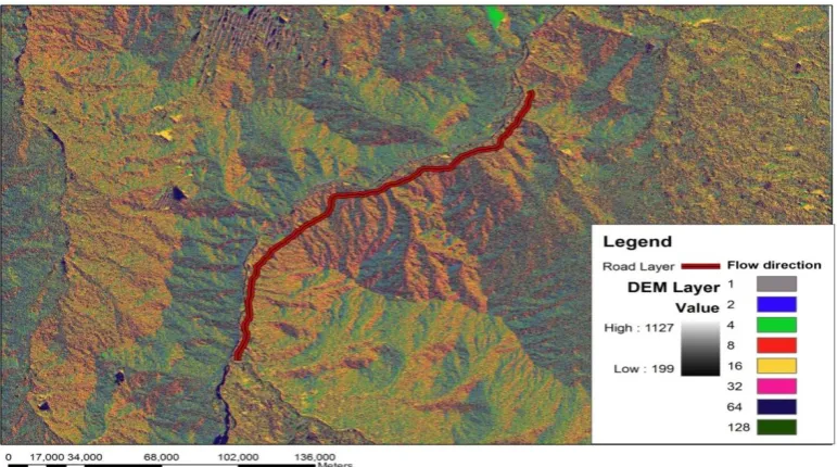
Most topographic surfaces have spurious sinks (low spots) that must be filled before perform any type of analysis. Sinks and peaks are often errors due to the resolution of the data or rounding of elevations to the nearest integer value. Sinks should be filled to ensure proper delineation of basins and streams. Water flowing into a sink is rapped, and the drainage path stops at that cell. Most sinks in a 7.5-minute DEM are between 2.6 and 4.8 meters deep6. Flow direction and flow accumulation were calculated directly from an elevation raster as presented in (Fig. 1 & Fig. 2). Conditional tool was used to extract the high-accumulation cells and turn all others into No Data, and then a raster representation of the drainage network for the surface was created.
Fig. 1: DEM after Flow Direction.
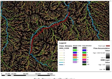
II.3.1 Ordering and Classification Streams
The raster representing a linear network was converted to vector representing the linear network, by using Stream to Feature tool in ArcGIS. The streams were classified according to "Grid Code" in attribute data of stream order as in Fig. 3.
Fig3: Streams after Classification
The important streams of the highest value of grid code was exported in a new layer, by using Select Analysis tool as in Fig. 4
The intersect analysis tool was used to determine the points of intersection between streams and the road ( Altahadi Road ).
III.
RESULT
AND
DISCUSSION
The result of the analysis is a new layer of point feature classes. These points represent the locations where water passes cross the road which needs bridges or level crossings design.
Fig. 5: The intersection locations
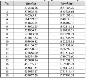
III.1 Test of the intersection points positional accuracy
To test the positional accuracy of the intersection points a set of 19 points were observed in the field over the existing bridges and level crossings (Table 1). A point feature class layer was prepared using the observed coordinates. The points layer representing the reality was overlaid on satellite imagery yielded from analysis for testing the overlapping of intersections from the two sources (Fig. 6).
Table 1: Coordinates of existing bridges and level crossings
No. Easting Northing
1 579578.76 1881086.29
2 574695.48 1865725.61
3 566385.11 1851092.40
4 564229.82 1848638.10
5 554695.75 1846402.70
6 548092.25 1842116.31
7 524966.71 1830457.29
8 528813.00 1833291.21
9 517077.82 1827325.94
10 503960.82 1822233.81
11 499166.62 1821751.60
12 483298.62 1806392.19
13 477658.00 1801511.23
14 464374.39 1789079.60
15 456030.36 1771531.13
16 455765.77 1769206.21
17 455611.54 1766112.52
18 455038.17 1751719.44
Fig. 6 Overlay result of the observed points on the satellite imagery
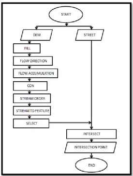
III.2 Model Builder
Hydrocross model was created to automate all the previous procedures through model builder in ArcGIS. The flow chart design of the model was presented in Fig. 7
IV.
CONCLUSION
In this paper digital elevation model was analyzed using the spatial analysis capabilities of the geographic information systems. Surface water drainage network was determined on the map including the locations where the streams intersect the road. A model builder was designed to automate the process for any other similar areas. This study can be used as a support tool for road network designation and for monitoring surface drainage network.
REFERENCES
[1] ASCE. GIS Modules and Distributed Models of the Watershed, Task Committee Report, Paul A. DeBarry and Rafael G. Quimpo Committee Co-chairs, 1999, ASCE.
[2] Biron, P. M., Choné, G., Buffin-Bélanger, T., Demers, S. and Olsen, T. Improvement of streams hydro-geomorphological assessment using LiDAR DEMs. Earth Surf. Process. Landforms, 2013, 38: 1808– 1821. doi: 10.1002/esp.3425
[3] Kevin. J, McMaster. Effects of digital elevation model resolution on derived stream network positions, Water Resour. Res., 2002, 38(4), doi:10.1029/2000WR000150.
[4] Jenson, S. K. Applications of hydrologic information automatically extracted from digital elevation models. Hydrol. Process, 1991, 5: 31–44. doi: 10.1002/hyp.3360050104
[5] Maidment, D.R.. Arc Hydro: GIS for Water Resources. EnvironmentalSystems Research Institute, Inc., 2002, Redlands, California.
[6] Mao, Y., Ye, A., Xu, J., Ma, F., Deng, X., Miao, C., Gong, W., and Di, Z.: An advanced distributed automated extraction of drainage network model on high-resolution DEM, Hydrol. Earth Syst. Sci. Discuss., 2014, 11, 7441-7467, doi:10.5194/hessd-11-7441-2014.