Abstract— Residual water level (non astronomic tide) obtained by removing astronomic tides from the observed tidal data and its relation to storm events have been studied in Jakarta, Semarang, and Surabaya waters, which are located along northern coasts of Java – Indonesia. The residual time series was analyzed with the occurrence of storms in the Western Pacific Ocean, namely Cyclones Peipah, Hagibis, and Mitag in November 2007.
It was found that the highest surge occurred after the Cyclone Peipah event on November 9, 2007. It was of about 38 cm in the Jakarta waters, 20 cm in the Semarang waters, and 21 cm in the Surabaya waters. In general, although the storm surge heights on November 9, 2007 were maximum, the total sea level still fell below the mean sea level (MSL) in the Jakarta and Surabaya waters, while it only rose to 5 cm above MSL in the Semarang waters because the surges were associated with the ebb condition of the astronomic tide. Therefore, the impact of storm surge height induced by the Cyclone Peipah was not significant.
On the other hand, although the storm surge height ( 10 cm) of the Cyclones Hagibis and Mitag on November 25, 2007 was not as high as that of the Cyclone Peipah ( 38 cm), in the Jakarta waters the total sea level rose up to 75 cm above the MSL coincided with the spring flood condition of the astronomic tide as well as perigee position of the moon. The total impact of the Cyclones Hagibis and Mitag was significant causing flooding along the northern land of Jakarta. Meanwhile, in the Surabaya Waters, the storm surge height induced by the Cyclones Hagibis and Mitag was of about 17 cm and had a significant contribution to the increasing of total sea level of about 35 cm above the MSL.
Index Term— astronomic tide, residual water level, storms, storm surges, storm tide.
I. INTRODUCTION
JAKARTA, Semarang, and Surabaya coastal areas located at the northern part of Java, Indonesia (as shown in Fig. 1) have often been hit and inundated by severe storm tide, which is a
Nining Sari Ningsih is with the Research Group of Oceanography, Faculty of Earth Sciences and Technology, ITB, Indonesia (e-mail:
Wisaksono Suryo was with the Study Program of Oceanography, Faculty of Earth Sciences and Technology, ITB, Indonesia (e-mail:
Suci Dewi Anugrah is with the Meteorological, Climatological, and Geophysical Agency of Indonesia (e-mail: [email protected]).
combination of the astronomical tides (the daily changes in water level due to gravitational interactions between the earth, moon, and sun), the storm surges (the transient changes due to the effects of a storm), and long-term changes (sea level rise, seasonal and decadal changes). The storm tide can cause severe flooding in coastal regions, especially in low-lying areas, frequently causing losses of lives and substantial economic damages. The degree of flooding depends on storm intensity, fluctuations in astronomically generated tides, and the slope of the continental shelf. Flooding is worst when surges coincide with high tides. Since coastal zones are at risk of storm tides, it is necessary to study crucial coastal zones affected by storm tide flooding, especially along northern coasts of Java.
Storm surge results from the interaction between atmospheric pressure depression and wind shear stress on the water surface. The advancing surge combines with the astronomical tide to create a storm tide. In general, Indonesian region is not a passage of tropical cyclone (storms), however, Indonesia will still experience indirect impact of the cyclone, such as strong wind, high waves (storm surge), and heavy rain along regions that near to the generation area of storms.
The northern coasts of Java closed to the South China Sea and the tropical region of the northwest Pacific Ocean, which are the path of the tropical cyclone during summer. Generally, there are 3 to 4 cyclones generated in the South China Sea and the tropical region of the northwest Pacific Ocean in averaged through the years. The trend of TropicalCyclone number has been increasing in recent years due to global warming [8].
The storm tide has caused serious disasters along the northern coasts of Java (e.g., the Jakarta and Semarang coastal areas), such as: houses and infrastructures around the coastal areas being totally flooded, hundreds of families being displaced, tourism activities being unavailable, and damage of fishing ships. Moreover, it is often disturbing access to the Soekarno-Hatta International Air Port of Jakarta. Therefore, study on storm tide characteristics along the northern coasts of Java is necessary, primarily from the view of flood defense. In this study, based on available observed tidal data, we have investigated the storm tide characteristics at some locations of
Study on Characteristics of Residual Water
Level in Jakarta, Semarang, and Surabaya
Waters – Indonesia and Its Relation to Storm
Events in November 2007
the coasts of Java, namely Jakarta, Semarang, and Surabaya in November – December 2007. We are interested to study the tidal observation data in the period of November – December 2007 because there was severe flooding caused by sea water along the northern land of Jakarta, especially in November 2007, and it was reported extensively in both electronic and print media.
As far as we know, storm tide investigation along the northern coasts of Java is still limited, especially study on storm surge characteristics studied by observed tidal data. In our previous study [6], we have investigated wave height, run-up, and inundation of storm tide along the northern coasts of Java, generated by tides and the Cyclones Hagibis and Mitag in November 2007 by using a two dimensional (2D) hydrodynamic model. The simulated results showed that although the Cyclones Hagibis and Mitag did not generate high storm surges along the coasts of Java (surge heights < 20 cm), the coasts were still severely flooded.
It is suggested that a storm in the South China Sea will be able to generate swell traveling south into the Jakarta Bay, which is located at the northern coast of Java. When that swell arrives at the Jakarta coast, it may meet a young sea state being generated by a local breeze from northerly directions. Based on a hydrodynamic simulation, Pandoe (2008) at http://www.ristek.go.id/index.php?mod=News&conf=v&id=24 29, from Agency for The Assessment and Application of Technology of Indonesia, reported that local wind speed of about 10.28 m/s will contribute to raise the water level of about 20 – 30 cm in the Jakarta Bay.
In this paper, we studied storm surge characteristics (e.g., surge-heights and periods) along the northern coasts of Java, especially in the Jakarta, Semarang, and Surabaya locations based on harmonic analysis and wavelet transform methods. By using the harmonic analysis method, the surge-heights were investigated based on residual water level obtained by removing the tidal part from the observed tidal data. Meanwhile, based on wavelet theory, it is able to understand the distribution of spectral density and frequency in the time domain. The application of the wavelet theory to analyze tidal data is gradually widely used in recent years, e.g., [2][5]. The researchers applied the wavelet transform method, which makes the judgment of the tidal data analysis easier.
II. DATA AND METHODOLOGY
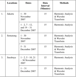
In this study, we used observed tidal data at 15-minutely intervals, which was obtained from The National Coordination Agency for Surveys and Mapping of Indonesia. The observed tidal data are available at the Jakarta, Semarang, and Surabaya locations in the period of November – December 2007. However, there were some missing observations. Detailed information of the available data during that period is shown in Table I.
To know meteorologically induced sea level changes, wind
and atmospheric pressure data as well as tropical cyclone data (Table II) have been collected. Depression tracks of the cyclones are not shown in this paper and they can be found at http://weather.unisys.com/hurricane/w_pacific/2007H/index.ht ml. Due to lack of local wind and atmospheric data, we used 6-hourly wind and atmospheric pressure data from NCEP (National Centers for Environmental Prediction) to calculate sea level changes caused by local wind set up and inverted barometer effect by using (1) and (2), respectively. Local wind set-up is approximately calculated by (Bowden, 1983):
sx
C x
g h
(1)
where represents changes in sea level over a finite horizontal distance x; sx is wind stress; 1 < C < 1.5; g is the
gravitational acceleration; is the density of water; and h is the mean depth of water. Meanwhile, changes in sea level due to a change in atmospheric pressure pa are given by
(Bowden, 1983):
1 a p g
. (2)
This is known as ”the inverted barometer effect” in which an increase in atmospheric pressure is accompanied by a decrease in sea level or vice versa.
TABLEI
THE AVAILABILITY OF OBSERVED TIDAL DATA AT LOCATIONS OF JAKARTA,
SEMARANG, AND SURABAYA IN THE PERIOD OF NOVEMBER –DECEMBER
2007
Locations Dates Data
Interval (Minutes)
Methods
1. Jakarta 1 - 30 November 2007
15 Harmonic Analysis & Wavelet Transform
1 - 2, 7 - 12, and 19 – 31 December 2007
15 Harmonic Analysis
2. Semarang 1 - 30 November 2007
15 Harmonic Analysis & Wavelet Transform
5 - 31 December 2007
15 Harmonic Analysis & Wavelet Transform
3. Surabaya 1 - 2, 5 - 10, 21 – 30 November 2007
15 Harmonic Analysis
1 – 31 December 2007
III. RESULTS AND DATA ANALYSIS
Meteorologically induced sea level changes can be seen most clearly after the tidal effects have been removed. Astronomic tide, obtained from harmonic analysis using T_TIDE Program [7], was subtracted from the observed sea level to product a residual curve. The residual sea level heights or non astronomic tide, usually known as meteorologically induced sea level changes, such as storm surge heights, local wind set-up, and inverted barometer effect.
Observed water level, astronomic tide, and residual sea level heights in the Jakarta Waters (marked by 1 in Fig. 1) are shown in Fig. 2 and it can be seen from the figure that highest residual sea level exist on November 9, 2007 of about 39 cm. To know how large surge heights generated by the Cyclones Peipah, Hagibis, and Mitag might exist in the Jakarta Waters, sea level changes induced by local wind set up as well as inverted barometer effect are calculated, as shown in Fig. 3. It is found that the sea level changes induced by local wind set up and inverted barometer effect are of about < 1 cm. Therefore, it suggested that the storm surge height induced by Typhoon - 1 Peipah is of about 38 cm. Further analysis shows that although the storm surge height on November 9, 2007 was maximum, the total sea level still fell below the mean sea level in associated with the ebb condition of the astronomic tide (Fig. 4). Therefore, the impact of storm surge height induced by Typhoon - 1 Peipah was not significant.
Meanwhile, during the Cyclones Hagibis (19 – 27 Nov 2007) and Mitag (20 – 27 Nov 2007), it was obtained that residual sea level height of about 12 cm on 25 November 2007 in which in that time sea level changes induced by local wind set up and inverted barometer effect being about < 1 cm and < 2 cm, respectively. Hence, it is suggested that the storm surge height induced by Cyclones Hagibis and Mitag was of about 10 cm. Although the storm surge height ( 10 cm) of the Cyclones Hagibis and Mitag was not as high as that of Cyclone Peipah ( 38 cm), total sea level rose up to 75 cm above the mean sea level in associated with the spring flood condition of the astronomic tide as well as perigee position of the moon (as shown in Fig. 5). Impact of the total sea level was significant causing flooding along the northern land of Jakarta. The flooding occurrence was reported extensively in both
electronic and print media.
TABLEII
TROPICAL CYCLONE DATA IN WESTERN PACIFIC OCEAN (SOURCE:UNISYS
WEATHER)
Name Date Max Wind
Speeds (knot) Air Pressure (mb) Category Based on Saffir-Simpson Scale
1 Typhoon-1 PEIPAH
03-09 NOV 2007
75 > 980 1
2 Typhoon-2 MITAG
20-27 NOV 2007
95 965-980 2
3 Typhoon-2 HAGIBIS
18-27 NOV 2007
85 965-980 2
TABLEIII
SEA LEVEL HEIGHTS AND IMPACT OF STORM SURGE HEIGHT INDUCED BY
TYPHOON -1PEIPAH IN THE JAKARTA,SEMARANG, AND SURABAYA
WATERS Jakarta Waters Semarang Waters Surabaya Waters
1.Spring Tidal Range (cm)
130 90 265
2.Neap Tidal Range (cm)
45 50 90
3.The Storm surge height induced by Typhoon-1 Peipah (cm)
38 20 21
4.The Total Sea Level during the Typhoon-1 Peipah
The total sea level still fell below the MSL in associated with the ebb condition of the astronomic tide
The total sea level just rose to 5 cm above the MSL in associated with the ebb condition of the astronomic tide Although the storm surge height on November 9, 2007 was maximum, the total sea level still fell below the MSL in associated with the ebb condition of the astronomic tide
5.The impact of storm surge height induced by Typhoon - 1 Peipah
Not significant
Not significant
Not significant
TABLEIV
IMPACT OF STORM SURGE HEIGHT INDUCED BY THE CYCLONES HAGIBIS
AND MITAG, AND PERIODS OF THE NON ASTRONOMICAL TIDES IN THE
JAKARTA,SEMARANG, AND SURABAYA WATERS
Jakarta Waters Semarang Waters Surabaya Waters
1.The storm surge height induced by the Cyclones Hagibis and Mitag (cm)
10 8 17
2.The Total Sea Level during the Cyclones Hagibis and Mitag
The total sea level rose up to 75 cm above the MSL in associated with the spring flood condition of the astronomic tide as well as perigee position of the moon
The total sea level rose up to 17 cm above the MSL in associated with the neap flood condition of the astronomic tide
The total sea level rose up to 35 cm above the MSL
3.The impact of storm surge height induced by the Cyclones Hagibis and Mitag Significantly causing flooding along the northern land of Jakarta
Not significant Significantly increasing the total sea level of about 35 cm above the MSL 4.Periods of the
Non Astronomical Tides
In addition, based on wavelet transform approach, we found the energy distribution of residual water level in the Jakarta
Waters during the Cyclones Peipah, Hagibis, and Mitag over frequency and time domains. It was found that periods of the non astronomical tides in the Jakarta Waters are about 1 - 4 days (Fig. 6).
We have also analyzed residual sea level heights in the Semarang and Surabaya Waters and their relation to the occurrence of storms in the Western Pacific Ocean (the Cyclones Peipah, Hagibis, and Mitag) as well as in the Jakarta Waters. Summary of the data processing results are shown in Tables III and IV.
IV. CONCLUSION
Residual water level characteristics in the Jakarta, Semarang, and Surabaya Waters – Indonesia and their relation to storm events (the Cyclones Peipah, Hagibis, and Mitag in November 2007) have been investigated. It was found that the maximum surges at the three locations are of about 21 – 38 cm after the Cyclone Peipah event, and they are of about 8 – 17 cm after the Cyclones Hagibis and Mitag. Based on this study, it was known that although the surge heights in the three locations are generally less than 40 cm, they may significantly contribute to generate flooding along the northern coast of Java, especially at the Jakarta coast, if the surge event coincided with the spring flood condition of the astronomic tide as well as perigee position of the moon as the case of flooding generated by the Cyclones Hagibis and Mitag along the northern land of Jakarta on November 25, 2007 in which total sea level rose up to 75 cm above the MSL.
In this study, we used 6-hourly wind and atmospheric pressure data from the NCEP to calculate sea level changes caused by local wind set up and inverted barometer effect. To obtain more accurate calculation of the sea level changes, it is necessary to use local wind and atmospheric data with high resolution both in space and time. Results of this present research can be used to verify and improve our previous modelling of storm tide flooding in the area of study [6]. This kind of study is currently in progress as an extension of this research work.
It is hoped that a better understanding of the characteristics of surge heights and astronomic tides at the three locations, which is obtained from this study, could be significantly valuable for designing both proper management plans and investment policies in the coastal water areas, primarily to reduce the risk of flooding caused by storm tide.
ACKNOWLEDGMENT
The in-situ data used in this study are provided by the National Coordination Agency for Surveys and Mapping of Indonesia. We gratefully acknowledge the supports.
REFERENCES
[1] K.F. Bowden, Physical Oceanography of Coastal Waters. Ellis Horwood Ltd., 1983.
[2] D. P. Chambers, C. A. Mehlhaff, T. J. Urban, and R. S. Nerem, “Analysis of Interannual and Low-Frequency Variability in Global Mean Sea Level from Altimetry and Tide Gauges,” Physics and Chemistry of the Earth, vol. 27, Issue 32-34, 2002, pp. 1407-1411. [3] C. C. Huang, “On the Supplement of Tidal Data and the Characteristic
of the Astronomical Tide Component,” Master Thesis, Department of Hydraulics & Ocean Engineering, National Cheng Kung University, Taiwan, 2005.
[4] C. B. Lee, C. C. Huang, C. C. Kao, and C. L. Z. Chuang, “Study on the Characteristics of Storm Surge over Taiwan Eastern Waters by Wavelet Transform,” in Proceedings of the Eighteenth International Offshore and Polar Engineering Conference, Vancouver, BC, Canada, 2008. [5] Y.H. Lim and L.M. Lye, “Wavelet Analysis of Tide-affected Low
Stream Flows Series,” Journal of Data Science, vol. 2, Number 2, 2004, pp. 149-163.
[6] N.S. Ningsih, S. Hadi, D. F. Saputri, F. Hanifah, and A. P. Rudiawan, “Simulation of Susceptible Areas to the Impact of Storm Tide Flooding along Northern Coasts of Java,” in Proceedings of Conference on Industrial and Applied Mathematics (CIAM 2010), Bandung, 6 – 7 July, 2010.
[7] R. Pawlowicz, B. Beardsley, and S. Lentz, “Classical Tidal Harmonic Analysis Including Error Estimates in MATLAB Using T_TIDE,” Computers & Geosciences, 28, 2002, pp. 929–937.
26 Okt 5 Nov 15 Nov 25 Nov 5 Des 15 Des 25 Des 4 Jan -50
0 50 100 150 200 250
Date/Month
Wa
te
r
L
e
v
e
l
(c
m
)
Original Time series Tidal prediction from Analysis Original time series minus Prediction
Jakarta, 1 Nov - 31 Des 2007
data prediction residue
Residual time series after removal of astronomic tides
Observation Astronomic Tides Residual Elevation Jakarta, 1 Nov – 31 Dec 2007
Spring Tidal Range : 130 cm Neap Tidal Range : 45 cm
11/04 11/14 11/24 12/04 12/14 12/24 1/03
ve
ktor
ke
ce
pata
n (m/s
)
U
3 m/s
W
ind
Spe
ed
(m
/s)
3 m/s
N
Hagibis Mitag Peipah
Residual Elevation
Dates
El
ev
at
io
n
(c
m
)
El
ev
at
io
n
(c
m
)
Local Wind Set Up
Inverted Barometer Effect
Fig. 3. Residual sea level heights, wind speed, local wind set up, and inverted barometer effect in the Jakarta Waters (marked by 1 in Fig. 1). The colour squares indicate the time periods of the Cyclones Peipah, Hagibis, and Mitag.
Dates