CSEIT1722312 | Received : 16 April 2017 | Accepted : 24 April 2017 | March-April-2017 [(2)2: 1000-1004]
International Journal of Scientific Research in Computer Science, Engineering and Information Technology © 2017 IJSRCSEIT | Volume 2 | Issue 2 | ISSN : 2456-3307
1000
Comparative Study of Algorithms for Hyper Spectral Image
Classification
Pallavi Juyal, Manish Jain, Varsha Nemade
Department Computer Engineering, Mukesh Patel School of Technology Management and Engineering, Shirpur, Maharashtra, India
ABSTRACT
Now days the use of remote sensing imagery has increased drastically, ranging from the applications in farms to that in the field of defense. These images range from hyper spectral, multispectral to ultra spectral. One of the major applications of the remote sensing image is that of classification of the image. Several algorithms have been found for classification of images based on various factors [4]. The algorithms used for classification are either supervised or unsupervised. In this paper we study different algorithms used for classification of the hyper spectral images. An analysis of the output obtained by the implementation of various algorithms has also been done. The analysis has been done based on the number of pixels classified.
Keywords : Remote Sensing, Hyperspectral Image, Classification, Classifier, Spectrum, Electromagnetic Spectrum, Euclidian Distance.
I.
INTRODUCTION
Remote sensing refers to the collection and analysis of data that is acquired by a satellite type instrument .With an example, remote sensing can be explained as follows, if we take the picture of a school building and in the picture we see that it is composed of doors, windows and roof all of which appear to be of different color, this is remote sensing. Classification of image is important part of remote sensing [6].
Remote sensing deals with these three components, a platform is needed to hold the instrument,a target object to be acquired and then observed and an instrument or a detector to sense and observe the target. The image shown below is an explanation of how remote sensing is actually performed.
Figure 1. Acquisition of Satellite Image
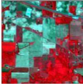
A hyper spectral imaging like any other multispec image deals essentially with the collection and processing of information by making use of the electromagnetic spectrum which is the range of all types of EM radiation. The naked human eye colour sees only colour in 3 bands, the RGB whereas a spectrum image separate the image into multiple bands. This technique of dividing the image into various different spectrums is far beyond the visible. Below is shown a hyper spectral image which will be used as a input in the implementation of the classification algorithm.
II.
LITERATURE SURVEY
Hyper-spectral remote sensing has been used in a wide array of applications. Although originally developed for mining and geology (the ability of hyper-spectral imaging to identify various minerals makes it an idealtechnique for the mining and oil industries, where it can be used extensively to look for ore and oil), it has now spread into fields as widespread as ecology and surveillance, as well as historical manuscript research, such as the imaging of the Archimedes Palimpsest. This technology is continuously becoming more and more available to the public. Organizations such as NASA and the USGS have catalogues of various minerals and their spectral signatures, and have posted them online to make them readily available for researchers [15].
III.
IMAGE CLASSIFICATION
Classification of the hyper spectral image basically refers to forming of clusters based on parameters such as similarity measure, distance measure among a few. For the task of classification, the acquisition of several hundred bands of an image needs to be done. Once an image has been classified it needs to be analyzed so as to check for its performance factor and optimality of the classification technique.
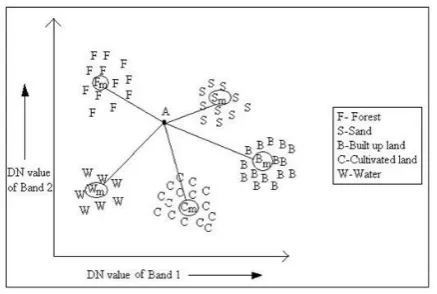
3.1 Minimum Distance classification-
This is a remote sensing classification system, based on taking distance as a parameter then leading to the formation of clusters[9]. The distance is stated as an index of likeliness so that the minimum distance is alike to the maximum similarity. The measure of homogeneity is a distance measure in the space of distribution functions. Minimum distance classification problems are categorized on the basis of the assumption made regarding the class distribution [2,7][13].
The figure given below gives an insight of the minimum distance classifier algorithm.
Figure 3. Minimum Distance Classifier
The commonly used distance calculation method is done by Euclidean distance formulae stated below.
√
3.2 Maximum likelihood classification
Figure 4. Maximum Likelihood
3.3 FUZZY C MEANS : One of the data clustering technique, in this technique a dataset is grouped into more than one cluster, with every data point in the dataset belonging to a cluster. In FCM method of clustering, a data point can be classified into one or more clusters. This algorithm is actually implemented by assigning membership to each data set or data point corresponding to the centre based on the distance between the centre of cluster and the data point. The more the data lies close to the cluster centre the more is its membership towards the corresponding cluster centre. The summation of membership of each data set should come nearly equal to the numeric value one [3].
∑ ∑
∑
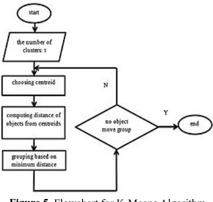
3.4 K Means Clustering-It is one of the simplest learning algorithm by forming clusters based on distance measure [10]. This technique is used when the data is without defined categories or group. The algorithm aims at working in an iterative manner which basically aims at assigning each data point to one of the k cluster based on distance as a feature [3][4]. Data points are clustered based on distance measure. The results of the K-means clustering algorithm are:
1. The centroids of the K clusters, which is used as a new data
2. Labels for the training data
The flowchart below describes the K-means algorithm.
Figure 5. Flowchart for K-Means Algorithm
IV.
IMPLEMENTATION AND OUTPUT
The image obtained after applying the various algorithms are shown below.
The figure is an outcome of applying the minimum distance algorithm.
Figure 6. Output of Minimum Distance
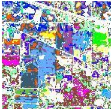
The figure is a result after the implementation of the k-means algorithm.
The figure shown below is an outcome of implementing the machine learning, fuzzy c means algorithm.
Figure 8. Output of Fuzzy C Means Algorithm
V.
PERFORMANCE AND ANALYSIS
The analysis done after comparing the various algorithm has been shown in the table below.
The comparison is done based on the number of pixels classified by each of the implemented algorithm [12].
Name of Based on the number of pixels classified
As per the table, we observed that the performance of the K-Means algorithm and the Fuzzy C means algorithm was much better than that of the minimum distance algorithm. The fuzzy C Means is very slow as compared to the k Means algorithm.
VI.
CONCLUSION
In this paper we have done acomparative study of algorithms for classification based on their performance
as per the number of pixels classified. Further studies need to be done so as improve the use of classifiers to increase the application of such methods. There is a need to develop new and improved algorithms for better classification of satellite imagery. This would save more human resources and time. From the comparison, we deduced that the performance based on the number of pixels classified is better for the K-Means algorithm and the Fuzzy C-K-Means algorithm is better than that of the minimum distance algorithm.
VII.
REFERENCES
[1]
Pushpendra Singh Sisodia, Vivekanand Tiwari, Anil Kumar, 2014. “A Comparative Analysis of Remote Sensing Image Classification Techniques”, 2014 InternationalConference on Advances in Computing,Communicationsand Informatics (ICACCI)[2]
K Perumal and R Bhaskaran, 2010. “supervised classification performance of multispectral images”. Journal of Computing, Volume 2, Issue 2, February 2010, ISSN 2151-9617.[3]
Vinoth Kumar, B., G. R. Karpagam, and N. Vijaya Rekha. "Performance Analysis of Deterministic Centroid Initialization Method for Partitional Algorithms in Image Block Clustering", Indian Journal of Science and Technology, 2015.[4]
Kanika, K., Anil, K, G. and Rhythm, G. 2013. "A Comparative Study of Supervised Image Classification Algorithms for Satellite Images", International Journal of Electrical, Electronics and Data Communication, Vol. 1, Issue 10, pp. 10-16.[5]
Offer, R. and Arnon, K. 2011. "Comparison of Methods for Land-Use Classification Incorporating Remote Sensing and GIS Inputs", EARSeLeProceedings, Vol.10, No. 1, pp. 27-45.[6]
Aykut, A., Eronat, A, H. and Necdet, T. 2004. "Comparing Different Satellite Image Classification Methods: An Application in Ayvalik District, Western Turkey",In Proc. XXth ISPRS Congress Technical Commission, ISPRS, Vol. XXXV Part B4, July 12-23, Istanbul, Turkey.[8]
Shila, H, N. and Ali, R, S. 2010. "Comparison of Land Covers Classification Methods in Etm+ Satellite Images (Case Study: Ghamishloo Wildlife Refuge)", Journal of Environmental Research and Development, Vol. 5, No.2, pp. 279-293.[9]
Maryam, N., Vahid, M, Z. and Mehdi, H. 2014. "Comparing different classifications of satellite imagery in forest mapping (Case study: Zagros forests in Iran)”, International Research Journal of Applied and Basic Sciences, Vol. 8, No. 7, pp. 1407-1415.[10]
Manoj, P., Astha, B., Potdar, M, B., Kalubarme, M, H. and Bijendra, A. 2013. "Comparison of Various Classification Techniques for Satellite Data", International Journal Of Scientific & Engineering Research, Vol. 4, Issue 2, pp. 1-6.[11]
Subhash, T., Akhilesh, S. and Seema, S. 2012. "Comparison of Different Image Classification Techniques for Land Use Land Cover Classification: An Application in Jabalpur District of Central India", International Journal of Remote Sensing and GIS, Vol. 1, Issue 1, pp. 26-31.[12]
Malgorzata, V, W., Anikó, K. and rzsébet, V. 2012. "Comparison of Different Image Classification Methods in Urban Environment", In Proc. International Scientific Conference on Sustainable Development & Ecological Footprint, March 26-27 2012, Sopron, Hungary.[13]
Wacker, A. G. and D. A. Landgrebe, "Minimum Distance Classification in Remote Sensing," LARS Information Note 030772, Laboratory for Applications of Remote Sensing, Purdue University, W. Lafayette, Indiana 47907, February, 1972.[14]
“Computer Vision” In Wikipedia. Retrieved 15OCT 2016, from
https://en.wikipedia.org/wiki/Computer_vision.
[15]
“Hyperspectral Imaging” in Wikipedia, Retrieved1st April 2017 from
http://en.wikipedia.org/wiki/Hyperspectral