Page 208
STUDY TO REGENERATE THE DEGRADED NEIGHBORHOOD OF SAN CARLO ON THE NORTHERN OUTSKIRT OF PADUA, ITALY
Enrico Pietrogrande, Alessandro Dalla Caneva
Department of Civil, Environmental and Architectural Engineering, University of Padua, Italy
Abstract
The San Carlo neighborhood with the church of San Carlo at its center is a degraded area in the northern outskirts of Padua, a city located near Venice in the Veneto region of north-eastern Italy. Once marked by a distinctive identity, this part of the outskirts of Padua has gradually lost its social and functional character.
The idea of restoring this decaying district has long been the subject of discussion by the local authorities. The neighborhood of San Carlo is one of the subjects recently investigated by students studying the ‘Architectural and Urban Composition 2' course on the Master’s Degree in Architectural Engineering at the University of Padua. Their ideas include a green piazza park, a community center and hall, a library, study rooms for students, additional parking, open space for the weekly market.
Key words: regeneration, public space, urban planning, memory
1. INTRODUCTION
The San Carlo neighborhood extends to the north beyond both the city wall of Padua and the Arcella district. Development began in the middle of the last century with the first public housing construction sites (Figure 1). The progressive increase in the population saw the area widen its limits and so acquire the characteristics of a working-class suburb composed of scattered spontaneous building developments.
As often happens in suburban neighborhoods, the San Carlo area has also become marginalized through time and is now devoid of its own identity. It developed according to building distribution criteria that favored sprawl which has affected the quality of the built environment outside the historical city center. The perception that these areas have degenerated and are dangerous places to live in has developed with the passage of time because the unstable crumbling dilapidated buildings sometimes still put the safety of the inhabitants at risk. A sense of abandonment by the institutions is now widespread among the community as the primary needs of the citizens are not met which are safety, hygiene, and a visually appealing built environment.
Page 209 2. CONTEXT
Initial expansion of the city of Padua beyond the city wall to the north started in 1842 with the inauguration of the Ferdinandea railway which stimulated the siting of industry and new housing for the workers.
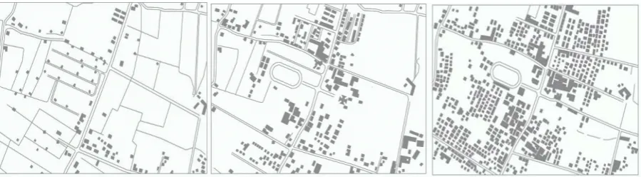
Figure 1. The development of the San Carlo neighborhood. From left to right: 1935, 1953, 1966.
Initially a working-class suburb of spontaneous and scattered buildings the area was to grow economically and demographically (Cenghiaro 2007) until it reached the size of the Arcella district today (Figure 2). At the start of the Twentieth Century the construction of the Borgomagno railway overpass created a new connection with the city center (Figure 3).
Page 210
Figures 2, 3 and 4. The Arcella and San Carlo neighborhoods seen from above, the Borgomagno railway overpass, and the church of San Carlo.
Page 211
Figures 7, 8. Planivolumetric representation of the San Carlo neighborhood (current state) and view of the church of San Carlo.
Nevertheless, in 1980 the district was still a long way from achieving the objectives established, the available areas were saturated, and the tissue was consequently heterogeneous and discontinuous, the reasons including the increase in population which quadrupled between the 1950s and the 1980s. This is the context in which the Vittorio Gregotti project was developed at the end of the 1980s. This project aimed to create a new centrality for Arcella at San Carlo by constructing four towers of which only one was actually built, and linear connection trunks that would delimit the open spaces.
The population of San Carlo has been strongly opposed to any building intervention in the area since 2006. The planning document of the Municipality 2016-2018 confirms that a fundamental aim is to redevelop the neighborhood. In particular, this will be achieved by antidegradation actions, the formation of meeting places, and the construction of a park in the vicinity of the church of San Carlo.
2.1. The San Carlo neighborhood and its main buildings
Today the San Carlo neighborhood is a much degraded area marked by the presence of several significant buildings (Figure 7). The building characterizing the empty central area is without doubt the parish church of San Carlo (Figure 8) which is set against the Colbachini stadium on the opposite side. These are the two presences around which the other main buildings and the residential buildings are arranged. The construction of the Colbachini stadium on the site of the Littorio sports field started in 1928 in order to create a sports pole.
As a monumental piece of architecture designed by Lorenzo Faccioli, the church reinterprets the formal natures of the Roman and Renaissance styles. Its nave was damaged by bombing in the Second World War but was restored after the war. Three buildings complete the parish complex is the kindergarten near the church which was started in 1946, the former youth center started in 1964 which is now a state school, and the parish center inaugurated in 1990 which includes an auditorium that hosts artistic and cultural events.
Page 212 2.2. Current problems
One of the main problems in the San Carlo neighborhood is that its formation and rapid growth have resulted in an uncontrolled increase in the population. In contrast, more recent years have seen a progressive depopulation and consequent degradation of the area and lack of community services. Further aggravating the situation and strongly perceived by the inhabitants is the considerable growth of foreign immigrant populations who have not integrated socially due to the lack of appropriate and welcoming reception structures. All of this equates to a decline in safety in the district.
Figures 9, 10, 11 and 12. Project planivolumetric plan and views. From the work of the students Stefania Capomolla and Elisa D’Agnolo.
From the point of view of urbanism, it must be emphasized that the road network had become overloaded with traffic congestion. The causes of all of this were the large amount of building without planning permission produced by the unplanned population increase, and the means of transport in the absence of an appropriate road network.
Another problem is the lack of public green spaces and above all the poor maintenance of the existing green areas, often abandoned and meeting places for micro-criminality. In summary, the San Carlo district lacks any cohesive public environment.
Page 213 3. THE DIDACTIC EXPERIENCE
The present study is centered on the original central nucleus of the San Carlo neighborhood, that is, the wide and unresolved open space between the church and Colbachini stadium. In the laboratory of the Architectural and Urban Composition 2 Course, the possibility of regenerating empty space marked by the church of San Carlo, the founding place of the neighborhood, by using realistic plans was verified by the students. The plans presented here are motivated by the shared aim of revitalizing the neighborhood by constructing public spaces as symbolic places of community life (De Biasio Calimani 2005).
The report of students Stefania Capomolla and Elisa D’Agnolo confirms how the neighborhood might be developed without meeting the needs of people. Spaces serving the community are almost non-existent. The neighborhood is disordered and lacks points of reference. The project idea the students refer to is the piazza park (Figure 9). The choice of the piazza park responds to the problems in the area and the wishes of the city administration and townspeople by offering to create a green heart (Figure 12) inside this neighborhood which is characterized by wild uncontrolled development symbolized by the Gregotti towers project.
The piazza is articulated in four modular platforms divided by a thin water feature which is staggered to propose a sense of variety. The project provides for the redevelopment of the Italian Olympic Committee offices as a Civic Center, a symbol of the rebirth of the San Carlo neighborhood.
Figures 13 and 14. From the work of Carlo Fornasieri and Marco Pittarella. Planivolumetric plan and views of the project.
Page 214
Activities for all of the categories composing the community in the neighborhood are planned inside the former Italian Olympic Committee offices, these categories being the elderly, children, students, and families. The ground floor is set aside for infants and children, particularly space organized for after-school and recreational activities. A portico structure has been added to the Italian Olympic Committee office building to make it more recognizable (Figures 10, 11) and act as a covered piazza and entrance to the building. A multi-use room or a projection room is designed as a flexible and adaptable space to host hundreds of people and to be used by the community for neighborhood meetings.
The water is inserted in the project several times but each one is designed in a very different shape and style from the others. Part of the green area has been equipped with facilities in modular buildings, designed for various functions according to age and purpose of the residents. The three ideas are to repopulate the neighborhood with young students, to provide a service for families with infant children, and to pay special attention to the most elderly generations.
The idea of students Carlo Fornasieri and Marco Pittarella originates from the observation that a meeting place does not exist in the neighborhood. In observing the physical and social degradation, here too it seemed almost natural to plan the area between the church and the sports field as a piazza park, (Figures 13, 16), a space for integrating the citizens, a place for cultural events, exhibitions and the market strongly requested by the citizens.
The ambitious idea is to define one single piazza that connects the church and the sports field by eliminating the problem of the main road that cuts the area into two parts now deprived of relationships due to the dearth of suitable pedestrian passages. To remedy the problem the students decided to opt for the elevated walkway solution over the main road (Figure 15). Choosing the walkway also provides a good view of the surrounding area and the buildings that surround the place. The Italian Olympic Committee office building is transformed into the new multipurpose neighborhood center. As the neighborhood is inhabited by a lot of students from outside Padua, the former Italian Olympic Committee offices has been functionally equipped with a public library and study room. The large glass surfaces of the building guarantee good illumination of the study room on the first floor.
Particular to this project is a new volume that accompanies the rise of the walkway on the eastern side. The building houses commercial activities on the ground floor away from the traffic and is covered by the terraced seating of an open air theatre facing towards the green space (Figure 14). The walkway and the new building constitute a single entity, planned as the scenery for the piazza.
Page 215
Figures 17, 18, 19 and 20. Planivolumetric plan of the project and perspectives. From the work of Micaela Birofio and Valentina Vötter.
Page 216
The area behind the Colbachini stadium is reorganized by two new L-shaped low-rise building (Figures 18, 19) that respectively close the volume of the former Arcobaleno cinema and the existing modest commercial volume on the opposite side, providing it with its own space. The local offices of the Italian Olympic Committee, an empty building without a function for some years, is recovered by keeping the external envelope, which is of great architectural quality, and modifying the inside (Figure 20). This building is historically significant as it is connected to the collective memory of the eldest in the community. Thanks to this and its esthetic quality, its reuse is considered to be indispensable (Ferlenga 2015). The building is planned as a civic center for the community and is provided with a library, minor spaces for meetings, and a conference hall.
The former Arcobaleno cinema, now a Bingo hall, was reassessed by keeping the external envelope and redesigning the inside as a cinema-theatre. The Colbachini stadium and the piazza in front of it on which the new civic center is sited are separated by a portal that identifies the entrance to the stadium. The presence of green areas and water opposite the church of San Carlo constitute a symbolic reference to the water that was once present throughout the area.
The project of Martina Langeli and Erika Raspagliesi is based on the idea of a large continuous green surface area (Figures 21, 23, 24), conforming to the expectations of the municipal government that planned San Carlo as a green heart in its 2016-2018 Programming Document. The entire surface area in front of the church is treated as a green space planned in parallel strips and planted with trees. A pedestrian walkway that becomes elevated along the road axis connects the new church square to the piazza in front of Colbachini stadium. The small piazza in front of the Italian Olympic Committee offices is paved in order to leave open space for the weekly market, a traditional event to which the community has been linked for many years (Figure 22).
In addition to the Gregotti building and the church, the green space is delimited by a new building that contains a library, a study room for the resident students, and which is connected to the parish center by a rotunda for collective uses. Here too the external shape and form of the Italian Olympic Committee offices is restored and its use changed to a civic center for the community. Inside the students propose a neighborhood cinema-theatre room, a meeting room, a bar and offices. The Italian Olympic Committee office building is empty on the ground floor in order to define collective public spaces in strict relationship with the external space of the small piazza. The problem of parking has been solved by providing an underground space beneath the library building.
Alessia Basile and Giacomo May proposed a continuous open space that unites the church of San Carlo with the Colbachini stadium (Figure 25). The unifying element is an underground pedestrian axis that crosses beneath the road, planned as a covered piazza and place with services for the townspeople.
Page 217
Figures 27 and 28. From the work of Rosario Contreras Vicente and Almudena Gallego Martinez. Project planivolumetric plan, project section through the square.
The empty space in front of the church is delimited by the church itself, by the Gregotti building, and by a new volume opposite the Gregotti building. This space becomes the new church square and public piazza, subdivided into green geometric areas crossed by routes that connect different areas of the neighborhood with each other. The new construction is planned as a multifunctional building for community services with various spaces for a library, study classrooms for students, and a civic classroom for the townspeople to participate in community life.
Corresponding to the Italian Olympic Committee offices is a small square planned for the market. The former offices are confirmed in their external shape and form (Figure 26) but restored inside in terms of function to become the police station for safety in the neighborhood.
As in previous cases, the idea of the plan by the Spanish Erasmus students Rosario Contreras Vicente e Almudena Gallego Martinez contain the construction of a public space, that is, a piazza park developed opposite the church of San Carlo. (Figure 27). The water, the greenery, and the urban street furniture are fundamental elements in the project (Figure 28). Routes arranged on various geometries cross the park and link the piazza to areas in the surrounding neighborhood. A pedestrian axis that connects the church of San Carlo with the Colbachini stadium, which is paved with local stone, is kept. A new building opposite the Italian Olympic Committee offices is planned as a covered market and to host collective spaces for community services: a library and an exhibition hall.
4. CONCLUSION
The San Carlo neighborhood has suffered phenomena of physical, social, and economic degradation. The slow but continuous decline of the area and its buildings has activated a progressive process of obsolescence that has inexorably involved the immediate urban context bringing with it social, economic, environmental, and urban planning and zoning implications.
Page 218 ACKNOWLEDGEMENTS
The authors would like to thank architect Luisa Calimani De Biasio who proposed the theme of the study, coordinating her development and participating in the meetings with the students. In addition, this article was translated from the original Italian into English by Clive Prestt.
REFERENCES
Baroni, A 1999, Quartiere 4: S. Carlo-Pontevigodarzere, Paltron, Bologna. Cenghiaro, E 2007, Padova al di là delle mura, Tracciati, Padova.
De Biasio Calimani, L 2005, Una piazza italiana, Cleup, Padova.
De Checchi, F 2010, 1900-1950: sobborghi d’epoca, Comune di Padova, Padova.
Ferlenga, A 2015, Città e memoria come strumenti del progetto, Christian Marinotti edizioni, Milano. Musco, F 2009, Rigenerazione urbana e sostenibilità, Franco Angeli, Milano.